Grove Copse

Wood, Forest in Somerset Somerset West and Taunton

England

Grove Copse

Bishop’s Lydeard: St Mary’s Church The impressive four-stage Somerset tower with set-back buttresses dates from the 15th century. The churchyard contains the stumps of two medieval crosses; the church is noted for its rood screen and carved 16th century bench ends
Bishop’s Lydeard: St Mary’s Church Credit: Martin Bodman

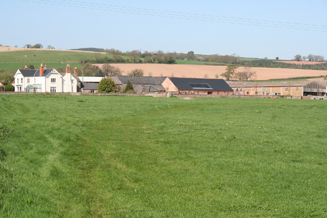
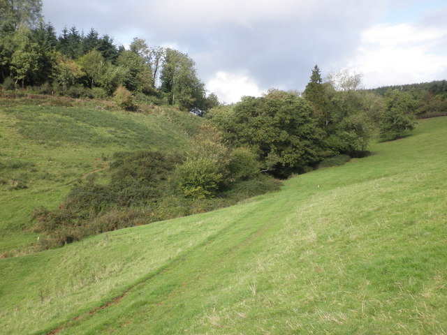
Grove Copse, located in the county of Somerset, England, is a picturesque wood that covers an area of approximately 50 acres. This enchanting forest is nestled in the heart of the Somerset countryside, offering visitors a peaceful and serene environment to explore and enjoy.

The copse is composed of a variety of tree species, including oak, beech, and ash, creating a lush and diverse ecosystem. The dense canopy of these tall, majestic trees provides ample shade and shelter for a wide array of wildlife, making it a haven for nature enthusiasts and birdwatchers alike. The forest floor is carpeted with a rich tapestry of ferns, wildflowers, and moss, adding to the beauty and tranquility of the surroundings.

Visitors to Grove Copse can embark on leisurely walks along well-maintained trails that wind their way through the wood. These pathways offer stunning views of the woodland and lead to a charming clearing where a small pond can be found, attracting an array of water-loving creatures such as frogs and dragonflies.

The copse is also home to a diverse range of bird species, making it an ideal spot for birdwatching. Songbirds, woodpeckers, and owls can often be heard and spotted among the trees, adding a delightful soundtrack to the woodland experience.

Grove Copse is a popular destination for families, couples, and nature lovers seeking respite from the hustle and bustle of everyday life. Its idyllic setting, lush vegetation, and diverse wildlife make it a hidden gem in the Somerset countryside, offering visitors a truly enchanting experience in the heart of nature.

If you have any feedback on the listing, please let us know in the comments section below.

Grove Copse Images

Images are sourced within 2km of 51.07289/-3.1706355 or Grid Reference ST1831. Thanks to Geograph Open Source API. All images are credited.

Bishop’s Lydeard: St Mary’s Church The impressive four-stage Somerset tower with set-back buttresses dates from the 15th century. The churchyard contains the stumps of two medieval crosses; the church is noted for its rood screen and carved 16th century bench ends
Bishop’s Lydeard: St Mary’s Church
The impressive four-stage Somerset tower with set-back buttresses dates from the 15th century. The churchyard contains the stumps of two medieval crosses; the church is noted for its rood screen and carved 16th century bench ends
Bishop’s Lydeard: Pound Farm At East Lydeard, the farm offers bed and breakfast. In the late 19th century one of the barns here had machinery powered by a waterwheel: a millstone survives near the house
Bishop’s Lydeard: Pound Farm
At East Lydeard, the farm offers bed and breakfast. In the late 19th century one of the barns here had machinery powered by a waterwheel: a millstone survives near the house
Kingston St Mary: Fennington Farm Looking north-north-east towards quite a sizeable farm complex
Kingston St Mary: Fennington Farm
Looking north-north-east towards quite a sizeable farm complex
Bishops Lydeard, St. Mary's Churchyard. C14 Cross.
Bishops Lydeard, St. Mary's Churchyard.
C14 Cross.
Methodist Chapel, Bishops Lydeard.
Telephone kiosk in Mount Street, Bishops Lydeard This is No 32 of 42 images of BT telephone boxes in Taunton Deane which BT is trying to cull due to their claimed 'lack of use'.
Telephone kiosk in Mount Street, Bishops Lydeard
This is No 32 of 42 images of BT telephone boxes in Taunton Deane which BT is trying to cull due to their claimed 'lack of use'.
Field near East Lydeard A glimpse through a fringe of trees that serves as a field boundary from T 4/11. The field rises gently towards East Lydeard Farm.
Field near East Lydeard
A glimpse through a fringe of trees that serves as a field boundary from T 4/11. The field rises gently towards East Lydeard Farm.
Field boundary near East Lydeard The row of trees, mostly willows, referred to in <a href="https://www.geograph.org.uk/photo/1407962">ST1729 : Field near East Lydeard</a>.
Field boundary near East Lydeard
The row of trees, mostly willows, referred to in ST1729 : Field near East Lydeard.
Churchyard cross, St Mary's Church Remains of a 14th century churchyard cross.
Churchyard cross, St Mary's Church
Remains of a 14th century churchyard cross.
St Mary's Church, Bishops Lydeard The church is known for its fine tower which is in the process of  being restored.
St Mary's Church, Bishops Lydeard
The church is known for its fine tower which is in the process of being restored.
Bench Mark, St Mary's Church The bench mark has been partially covered by a drain surround that has recently been put in place.  For a view of the church <a href="https://www.geograph.org.uk/photo/1908611">ST1629 : St Mary's Church, Bishops Lydeard</a> and for information about the cut mark <span class="nowrap"><a title="http://www.bench-marks.org.uk/bm34638" rel="nofollow ugc noopener" href="http://www.bench-marks.org.uk/bm34638">Link</a><img style="margin-left:2px;" alt="External link" title="External link - shift click to open in new window" src="https://s1.geograph.org.uk/img/external.png" width="10" height="10"/></span>
A bench mark is an Ordnance Survey arrowhead sign found on walls, bridges, churches and specially erected triangulation pillars where the altitude above sea-level has been accurately measured by surveyors.  The arrowhead points to a horizontal line above it which marks the exact altitude.  
With rivets and pivots there is no datum (horizontal line) cut, the pointed-to horizontal surface defining the datum height.
Bench Mark, St Mary's Church
The bench mark has been partially covered by a drain surround that has recently been put in place. For a view of the church ST1629 : St Mary's Church, Bishops Lydeard and for information about the cut mark LinkExternal link A bench mark is an Ordnance Survey arrowhead sign found on walls, bridges, churches and specially erected triangulation pillars where the altitude above sea-level has been accurately measured by surveyors. The arrowhead points to a horizontal line above it which marks the exact altitude. With rivets and pivots there is no datum (horizontal line) cut, the pointed-to horizontal surface defining the datum height.
Sign for the Bird in Hand
Street scene, Bishops Lydeard The K6 type telephone box is partially hidden by the bushes.
In 1935, the Post Office commissioned a new kiosk from Sir Giles Gilbert Scott to celebrate the Jubilee of King George V.  The K6 Jubilee Kiosk, as it is known, was similar to the K2 box, being made of cast iron and painted red but was 25% lighter in weight.  By the end of the 1930s there were 20,000 K6 telephone boxes in use all over the UK.
Street scene, Bishops Lydeard
The K6 type telephone box is partially hidden by the bushes. In 1935, the Post Office commissioned a new kiosk from Sir Giles Gilbert Scott to celebrate the Jubilee of King George V. The K6 Jubilee Kiosk, as it is known, was similar to the K2 box, being made of cast iron and painted red but was 25% lighter in weight. By the end of the 1930s there were 20,000 K6 telephone boxes in use all over the UK.
The Bird in Hand, Bishops Lydeard For a closer view of the sign <a href="https://www.geograph.org.uk/photo/1908709">ST1629 : Sign for the Bird in Hand</a>
The Bird in Hand, Bishops Lydeard
For a closer view of the sign ST1629 : Sign for the Bird in Hand
Secluded valley, near Ivyton Farm
The Bird in Hand, Bishops Lydeard
The Co-op, Bishops Lydeard
St Mary's Church, Bishops Lydeard
Show me another place!

Grove Copse is located at Grid Ref: ST1831 (Lat: 51.07289, Lng: -3.1706355)

Administrative County: Somerset

District: Somerset West and Taunton

Police Authority: Avon and Somerset

What 3 Words

///purified.adventure.seducing. Near Bishops Lydeard, Somerset

Related Wikis

Cothelstone

Cothelstone is a village and civil parish in Somerset, England, situated in the Quantock Hills six miles north of Taunton. The parish, which includes the...
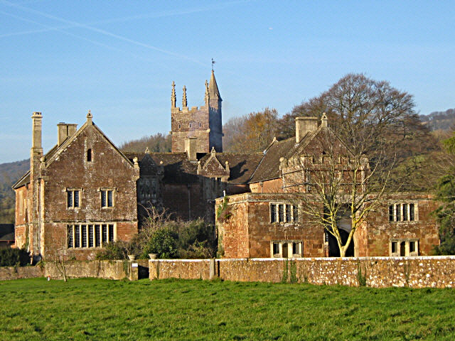
Cothelstone Manor

Cothelstone Manor in Cothelstone, Somerset, England was built in the mid-16th century, largely demolished by the parliamentary troops in 1646 and rebuilt...

Bishops Lydeard A.F.C.

Bishops Lydeard Association Football Club is a football club based in Bishops Lydeard, near Taunton, in Somerset, England. They are currently members of...
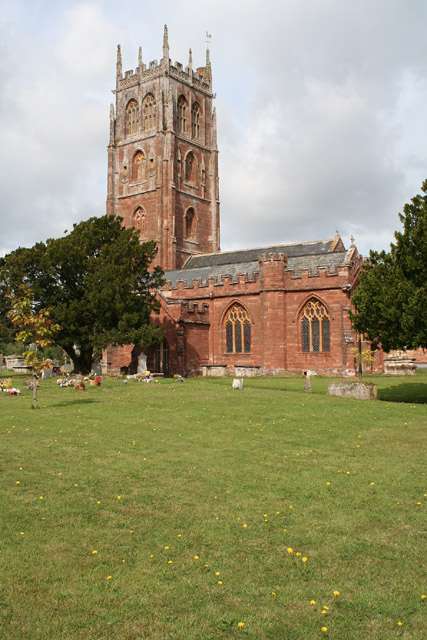
Bishops Lydeard

Bishops Lydeard () is a village and civil parish located in Somerset, England, 5 miles (8 km) north-west of Taunton. The civil parish encompasses the hamlets...

Lydeard House

Lydeard House in Bishops Lydeard, Somerset, England was built in the mid 18th century. It is a Grade II* listed building. == History == Lydeard House was...

Seven Sisters (Quantock Hills)

The Seven Sisters is a clump of beech trees on Cothelstone Hill in the Quantock Hills, England. Originally planted in the 18th century, they form a well...

West Bagborough Hoard

The West Bagborough Hoard is a hoard of 670 Roman coins and 72 pieces of hacksilver found in October 2001 by metal detectorist James Hawkesworth near...

Bishops Lydeard Mill and Rural Life Museum

The Bishops Lydeard Mill and Rural Life Museum is a historic building and museum in Bishops Lydeard, Somerset, England. The building dates from the 18th...

Nearby Amenities

Located within 500m of 51.07289,-3.1706355
Power: pole
Lat/Long: 51.0761535/-3.1754278
Brand: National Grid
Brand Wikidata: Q1465461
Material: wood
Operator: National Grid Electricity Distribution Plc
Operator Old: Western Power Distribution
Operator Wikidata: Q7988183
Owner: National Grid Electricity Distribution (South West) Plc
Owner Wikidata: Q114397866
Power: pole
Lat/Long: 51.0728707/-3.1724568
Brand: National Grid
Brand Wikidata: Q1465461
Material: wood
Operator: National Grid Electricity Distribution Plc
Operator Old: Western Power Distribution
Operator Wikidata: Q7988183
Owner: National Grid Electricity Distribution (South West) Plc
Owner Wikidata: Q114397866
Power: pole
Lat/Long: 51.075693/-3.1750221
Brand: National Grid
Brand Wikidata: Q1465461
Material: wood
Operator: National Grid Electricity Distribution Plc
Operator Old: Western Power Distribution
Operator Wikidata: Q7988183
Owner: National Grid Electricity Distribution (South West) Plc
Owner Wikidata: Q114397866
Power: pole
Lat/Long: 51.0747426/-3.1741639
Brand: National Grid
Brand Wikidata: Q1465461
Material: wood
Operator: National Grid Electricity Distribution Plc
Operator Old: Western Power Distribution
Operator Wikidata: Q7988183
Owner: National Grid Electricity Distribution (South West) Plc
Owner Wikidata: Q114397866
Power: pole
Lat/Long: 51.069687/-3.169253
Brand: National Grid
Brand Wikidata: Q1465461
Material: wood
Operator: National Grid Electricity Distribution Plc
Operator Old: Western Power Distribution
Operator Wikidata: Q7988183
Owner: National Grid Electricity Distribution (South West) Plc
Owner Wikidata: Q114397866
Power: pole
Lat/Long: 51.0719173/-3.1715951
Brand: National Grid
Brand Wikidata: Q1465461
Material: wood
Operator: National Grid Electricity Distribution Plc
Operator Old: Western Power Distribution
Operator Wikidata: Q7988183
Owner: National Grid Electricity Distribution (South West) Plc
Owner Wikidata: Q114397866
Power: pole
Lat/Long: 51.0708171/-3.1704475
Brand: National Grid
Brand Wikidata: Q1465461
Material: wood
Operator: National Grid Electricity Distribution Plc
Operator Old: Western Power Distribution
Operator Wikidata: Q7988183
Owner: National Grid Electricity Distribution (South West) Plc
Owner Wikidata: Q114397866
Power: pole
Lat/Long: 51.0737964/-3.1733108
The data included in this document is from www.openstreetmap.org. The data is made available under ODbL.

Have you been to Grove Copse?

Leave your review of Grove Copse below (or comments, questions and feedback).