Bangor

Community in Caernarfonshire

Wales

Bangor

A tiled shop doorway on the High Street, Bangor
A tiled shop doorway on the High Street, Bangor Credit: Meirion

Bangor is a community located in the historical county of Caernarfonshire, Wales. Situated on the northern coast of Wales, it lies on the southern shore of the Menai Strait, opposite the city of Anglesey. Bangor is the oldest city in Wales and has a rich history dating back over 1,500 years.

The community of Bangor has a population of approximately 18,800 people, making it one of the larger settlements in the area. It is known for its vibrant cultural scene, with the presence of Bangor University contributing to a youthful and energetic atmosphere. The university is renowned for its academic excellence, particularly in subjects like science, technology, and the arts.

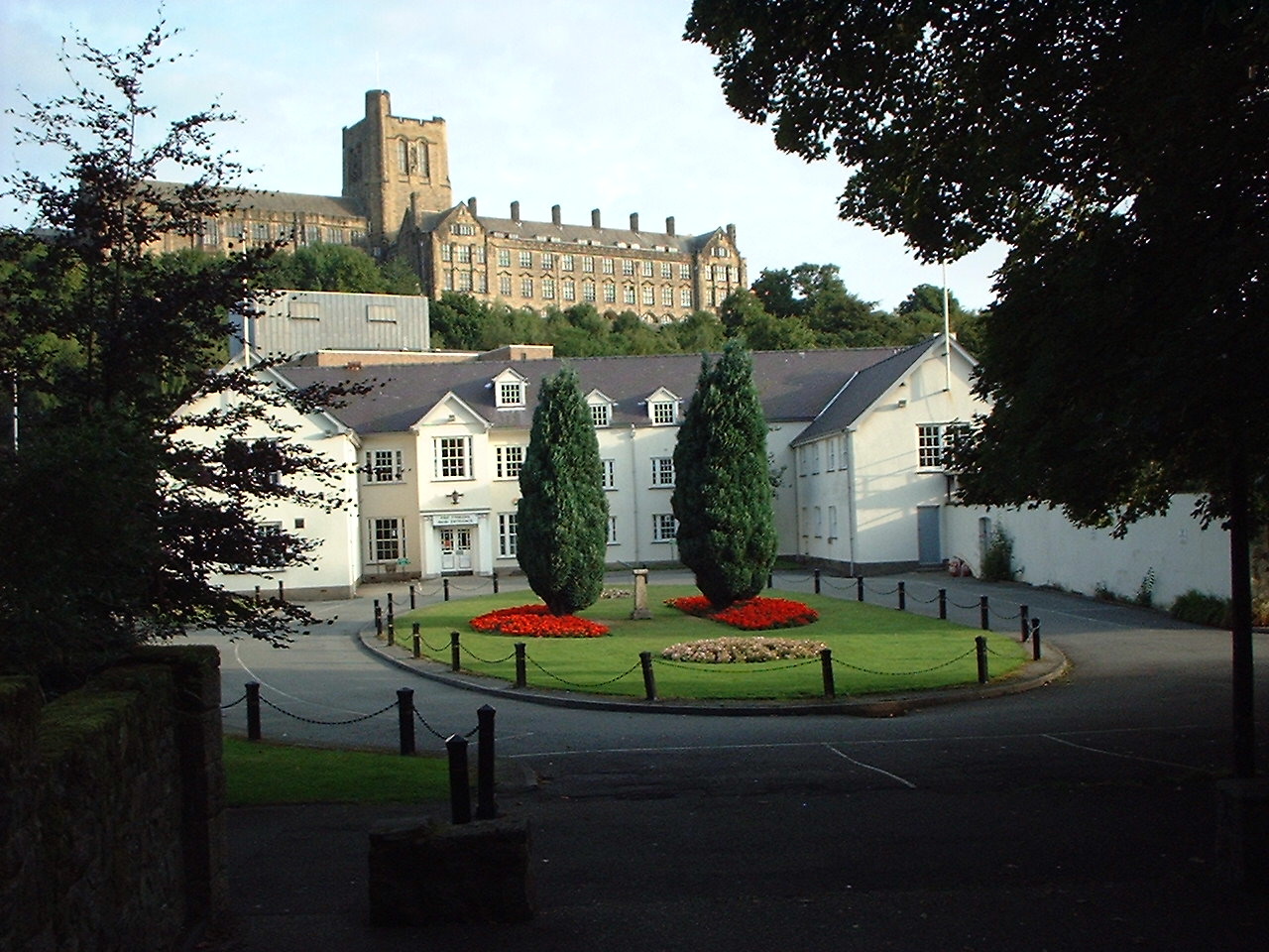
The city's central focal point is the iconic Bangor Cathedral, which dominates the skyline with its stunning Gothic architecture. The cathedral dates back to the 6th century and is a popular tourist attraction, drawing visitors from all over the world.

In addition to its historical and cultural significance, Bangor offers residents and visitors a variety of recreational activities. The city is surrounded by beautiful natural landscapes, including the nearby Snowdonia National Park, which is a haven for outdoor enthusiasts and nature lovers. The coastline provides opportunities for water sports and leisurely walks along the shore.

Bangor is well-served by transportation links, with a railway station connecting it to major cities like Manchester and London. Additionally, the A55 expressway provides easy access to other parts of Wales and England.

Overall, Bangor is a thriving community that combines its rich heritage, academic excellence, and beautiful surroundings to create a unique and attractive destination in Caernarfonshire.

If you have any feedback on the listing, please let us know in the comments section below.

Bangor Images

Images are sourced within 2km of 53.223233/-4.134466 or Grid Reference SH5771. Thanks to Geograph Open Source API. All images are credited.

A tiled shop doorway on the High Street, Bangor
"G" access cover on the High Street, Bangor "G" for gas?
"G" access cover on the High Street, Bangor
"G" for gas?
Sluice valve marker on Garth Road, Bangor
Worn hydrant sign with sticker on Garth Road, Bangor
Sluice valve marker on Garth Road, Bangor
Fire switch on the High Street, Bangor
Coat of arms on the Dean Street university building, Bangor
Hydrant marker on Beach Road, Bangor
Telemetry bollard on Maes Isalaw, Bangor
A graffiti cat with 5 legs on Snowdon View, Bangor
Hydrant sign on Siliwen Road, Bangor
Washout valve marker on Siliwen Road, Bangor
Damaged GPO Cross Connection Pillar on College Road, Bangor <span class="nowrap"><a title="http://www.ringbell.co.uk/nostalgia/AAS.htm" rel="nofollow ugc noopener" href="http://www.ringbell.co.uk/nostalgia/AAS.htm">Link</a><img style="margin-left:2px;" alt="External link" title="External link - shift click to open in new window" src="https://s1.geograph.org.uk/img/external.png" width="10" height="10"/></span>
Damaged GPO Cross Connection Pillar on College Road, Bangor
Hydrant sticker on Siliwen Road, Bangor
Fire switch on Waterloo Street, Bangor
Old electrical cabinet on Holyhead Road, Bangor
Sluice valve marker on Siliwen Road, Bangor
Show me another place!

Bangor is located at Grid Ref: SH5771 (Lat: 53.223233, Lng: -4.134466)

Unitary Authority: Gwynedd

Police Authority: North Wales

What 3 Words

///without.stated.loosed. Near Bangor, Gwynedd

Related Wikis

Bangor railway station (Wales)

Bangor railway station serves the city of Bangor, Gwynedd; it is operated by Transport for Wales. The station, which is 24+3⁄4 miles (40 km) east of Holyhead...

Farrar Road Stadium

Farrar Road Stadium was a multi-purpose stadium in Bangor, Wales. The site of the ground is now covered by an Asda supermarket. From 1920, the year it...

Grŵp Llandrillo Menai

Grŵp Llandrillo Menai (GLlM) is an umbrella organisation overseeing the operation of three member colleges in North Wales: Coleg Llandrillo, Coleg Menai...

Bala-Bangor Theological Seminary

Bala-Bangor was a theological seminary belonging to the Welsh Independents (Undeb yr Annibynwyr Cymraeg), an association of Welsh congregationalists....

Deiniol (electoral ward)

Deiniol is one of eight electoral wards in the city of Bangor, Gwynedd, Wales, electing councillors to the city and county councils. == Description... ==

Hendre (Bangor electoral ward)

Hendre is one of eight electoral wards in the city of Bangor, Gwynedd, Wales. The ward covers part of the city south of the city centre, including West...

Bangor Cathedral

Bangor Cathedral (Welsh: Eglwys Gadeiriol Bangor) is the cathedral church of Bangor, Gwynedd, Wales. It is dedicated to its founder, Saint Deiniol. The...

Bangor Town Hall

Bangor Town Hall (Welsh: Neuadd y Dref Bangor), formerly The Bishop's Palace (Welsh: Plas yr Esgob), is a municipal building on Ffordd Deiniol, in Bangor...

Nearby Amenities

Located within 500m of 53.223233,-4.134466
Mini Roundabout
Direction: clockwise
Lat/Long: 53.2210001/-4.1363535
Mini Roundabout
Direction: clockwise
Lat/Long: 53.2265058/-4.1346928
Traffic Signals
Traffic Signals: signal
Traffic Signals Direction: forward
Lat/Long: 53.2230051/-4.1352411
Post Box
Lat/Long: 53.226052/-4.1339247
Atm
Check Date: 2024-03-02
Lat/Long: 53.2260263/-4.1340303
Telephone
Booth: KX100
Covered: booth
Lat/Long: 53.2231701/-4.1353248
Garden Hotel
Addr City: Bangor
Addr Housenumber: 1-3
Addr Postcode: LL57 1DQ
Addr Street: Stryd Fawr
Addr Street En: High Street
Stars: 3
Tourism: hotel
Website: http://gardenhotel.co.uk/
Lat/Long: 53.2226486/-4.133309
Post Box
Brand: Royal Mail
Brand Wikidata: Q638098
Collection Times: Mo-Fr 17:30; Sa 11:15
Mapillary: 5235173066571781
Operator: Royal Mail
Operator Wikidata: Q638098
Post Box Type: pillar
Ref: LL57 2
Royal Cypher: EIIR
Royal Cypher Wikidata: Q33102113
Survey Date: 2022-06-15
Lat/Long: 53.2231587/-4.13139
Bus Stop
Bangor Railway Station
Bench: yes
Bin: yes
Bus: yes
Local Ref: H
Naptan AtcoCode: 5400AWF80913
Naptan NaptanCode: gwnamgp
Public Transport: platform
Shelter: yes
Lat/Long: 53.2234619/-4.13543
Bus Stop
Bangor Morrisons
Bench: yes
Bin: yes
Bus: yes
Naptan AtcoCode: 5400AWF80915
Naptan NaptanCode: gwnamaw
Public Transport: platform
Shelter: yes
Lat/Long: 53.2258516/-4.134857
Bus Stop
Bangor Morrisons
Bench: no
Bin: yes
Bus: yes
Naptan AtcoCode: 5400AWP26219
Naptan NaptanCode: gwnamda
Public Transport: platform
Shelter: yes
Lat/Long: 53.225761/-4.1350769
Post Box
Post Box Design: type_k
Post Box Type: pillar
Royal Cypher: EIIR
Royal Cypher Wikidata: Q33102113
Lat/Long: 53.2212954/-4.1385151
Telephone
Booth: KX100
Check Date: 2022-06-15
Covered: booth
Lat/Long: 53.2258854/-4.1358058
Post Box
Lat/Long: 53.2264075/-4.1348827
Recycling
Location: overground
Recycling Glass Bottles: yes
Recycling Type: container
Lat/Long: 53.2275473/-4.1343891
Bus Stop
Upper Bangor Leisure Centre
Bus: yes
Public Transport: platform
Shelter: no
Lat/Long: 53.224313/-4.1402933
Bus Stop
Llys Tryfan
Bus: yes
Public Transport: platform
Lat/Long: 53.2252835/-4.138395
Bar
Bar Uno
Addr City: Bangor
Addr Housename: Bar Uno
Addr Postcode: LL57 2JW
Addr Street: Ffordd Ffriddoedd
Name Cy: Bar Uno (Llawr isaf)
Opening Hours: Mo-Su 12:00-23:00
Operator: Bangor University
Phone: +44 1248 388888
Website: http://baruno.bangor.ac.uk
Lat/Long: 53.2261739/-4.1386447
Bus Stop
Ffordd Deiniol
Bus: yes
Public Transport: platform
Shelter: yes
Lat/Long: 53.2265762/-4.1300812
Barrier: bollard
Lat/Long: 53.2245992/-4.1286998
Bus Stop
Bangor Railway Station
Bench: yes
Bin: yes
Bus: yes
Local Ref: J
Public Transport: platform
Shelter: yes
Lat/Long: 53.2233916/-4.1348626
Bus Stop
Ffordd Deiniol
Bus: yes
Public Transport: platform
Lat/Long: 53.2247881/-4.1326113
Barrier: entrance
Lat/Long: 53.2249351/-4.1301462
Bus Stop
Bus: yes
Public Transport: platform
Lat/Long: 53.2214424/-4.1357172
Turning Circle
Lat/Long: 53.2203115/-4.1380926
Pub
Rascals
Addr City: Bangor
Addr Postcode: LL57 2PT
Addr Street: Allt Glanrafon
Check Date: 2024-03-02
Fhrs Id: 41824
Fhrs Local Authority Id: 10349
Wikidata: Q80583247
Lat/Long: 53.2269156/-4.1341571
Doctors
Healthcare: doctor
Lat/Long: 53.2254854/-4.1348926
Late Shop
Addr Housenumber: 13
Addr Postcode: LL57 2EG
Addr Street: Ffordd Caergybi
Check Date: 2024-03-02
Fhrs Id: 105932
Fixme: FHRS has Late Stop (not Shop)
Shop: kiosk
Lat/Long: 53.2271968/-4.1343699
The Wash House
Laundry Service: yes
Self Service: yes
Shop: laundry
Lat/Long: 53.2271206/-4.1344141
Dimensions
Addr City: Bangor
Addr Housenumber: 15
Addr Postcode: LL57 2EG
Addr Street: Ffordd Caergybi
Check Date: 2024-03-02
Fhrs Id: 125177
Fhrs Local Authority Id: 5369
Organic: only
Shop: convenience
Lat/Long: 53.2272594/-4.134333
Fast Food
Bella Take Away
Addr City: Bangor
Addr Housenumber: 8
Addr Postcode: LL57 2EG
Addr Street: Ffordd Caergybi
Alt Name: Bella House Takeaway
Check Date: 2024-03-02
Cuisine: pizza
Fhrs Id: 918373
Fhrs Local Authority Id: 25151
Lat/Long: 53.2270453/-4.1342164
Restaurant
Dragon
Addr City: Bangor
Addr Housenumber: 10
Addr Postcode: LL57 2EG
Addr Street: Ffordd Caergybi
Alt Name: Dragon Noodle Bar
Check Date: 2024-03-02
Cuisine: chinese;noodle
Fhrs Id: 71053
Fhrs Local Authority Id: 16084
Lat/Long: 53.2270973/-4.1341675
Cafe
Univape & Cbd Store
Addr City: Bangor
Addr Housenumber: 12
Addr Postcode: LL57 2EG
Addr Street: Ffordd Caergybi
Addr Street En: Holyhead Road
Fhrs Id: 1221433
Fhrs Local Authority Id: 27316
Old Name: Greek
Shop: e-cigarette
Lat/Long: 53.2271869/-4.134158
Charity Shop
Addr Housenumber: 16
Addr Postcode: LL57 2EG
Addr Street: Ffordd Caergybi
Shop: clothes
Source Addr: interpolation
Lat/Long: 53.2272364/-4.1341566
Cafe
Mike's Bites
Addr City: Bangor
Addr Housenumber: 18
Addr Postcode: LL57 2EG
Addr Street: Ffordd Caergybi
Alt Name: Mike's Bites Cafe
Check Date: 2024-03-02
Fhrs Id: 45257
Fhrs Local Authority Id: 10981
Lat/Long: 53.2272719/-4.1340907
Fast Food
Tai Sing
Addr Housenumber: 17
Addr Postcode: LL57 2EG
Addr Street: Ffordd Caergybi
Cuisine: chinese
Lat/Long: 53.2273169/-4.1343075
Fast Food
The University Plaice
Addr Housenumber: 21
Addr Postcode: LL57 2EU
Addr Street: Ffordd Caergybi
Cuisine: fish_and_chips
Fhrs Id: 133202
Lat/Long: 53.2274192/-4.1342403
Barrier: lift_gate
Lat/Long: 53.2262949/-4.1312918
Barrier: lift_gate
Lat/Long: 53.2269714/-4.1308851
Recycling
Lat/Long: 53.2256142/-4.1344669
Pharmacy
Rowlands Pharmacy
Addr City: Bangor
Addr Housenumber: 29
Addr Postcode: LL57 2EU
Addr Street: Ffordd Caergybi
Brand: Rowlands Pharmacy
Brand Wikidata: Q62663235
Dispensing: yes
Fhrs Id: 801091
Fhrs Local Authority Id: 6849
Healthcare: pharmacy
Name Cy: Fferyllfa Rowlands
Lat/Long: 53.2275898/-4.1341707
Varsity
Addr City: Bangor
Addr Housenumber: 146-148
Addr Postcode: LL57 1NT
Addr Street: Stryd Fawr
Addr Street En: High Street
Disused Amenity: pub
Fhrs Id: 1206380
Fhrs Local Authority Id: 27225
Old Name: Joop
Real Ale: yes
Wikidata: Q80583262
Lat/Long: 53.225113/-4.1277684
Pub
The Harp
Addr City: Bangor
Addr Housename: Y Harp Inn
Addr Housenumber: 78-82
Addr Postcode: LL57 1NS
Addr Street: Stryd Fawr
Addr Street En: High Street
Fhrs Id: 1052202
Fhrs Local Authority Id: 26217
Operator: The Harp Inn Ltd
Wikidata: Q29483790
Lat/Long: 53.2238509/-4.1295815
Fast Food
Domino's
Addr City: Bangor
Addr Country: GB
Addr Postcode: LL57 1NP
Addr Street: Stryd Fawr
Addr Street En: High Street
Brand: Domino's
Brand Wikidata: Q839466
Brand Wikipedia: en:Domino's Pizza
Contact Website: https://www.dominos.co.uk/pizza-near-me/bangor/2-high-street
Cuisine: pizza
Delivery: yes
Diet Vegan: yes
Diet Vegetarian: yes
Fhrs Id: 83397
Fhrs Local Authority Id: 20403
Takeaway: yes
Lat/Long: 53.2225203/-4.1327047
Pub
The Black Bull Inn
Addr City: Bangor
Addr Country: GB
Addr Housenumber: 107
Addr Postcode: LL57 1NS
Addr Street: Stryd Fawr
Addr Street En: High Street
Alt Name: Y Tarw Du
Brand: Wetherspoon
Brand Wikidata: Q6109362
Brand Wikipedia: en:Wetherspoons
Breakfast: yes
Contact Website: https://www.jdwetherspoon.com/pubs/all-pubs/wales/gwynedd/the-black-bull-inn-bangor
Diet Gluten Free: yes
Diet Vegan: yes
Diet Vegetarian: yes
Fhrs Id: 44802
Fhrs Local Authority Id: 10857
Food: yes
Internet Access: wlan
Internet Access Fee: no
Name Cy: Y Tarw Du
Outdoor Seating: yes
Real Ale: yes
Smoking: outside
Toilets: yes
Toilets Access: customers
Lat/Long: 53.2244595/-4.1289646
Conference and Catering
Name Cy: Cynadleddau ac Arlwyo
Operator: Bangor University
Phone: +44 1248 388399
Website: https://www.bangor.ac.uk/conference_office
Lat/Long: 53.2254922/-4.1386056
Library
Deiniol Library
Name Cy: Llyfrgell Deiniol
Operator: Bangor University
Phone: +44 1248 382984
Website: https://www.bangor.ac.uk/library
Lat/Long: 53.2256791/-4.130917
Elidir
Name Cy: Elidir
Operator: Bangor University
Website: https://www.bangor.ac.uk/accommodation/halls/elidir
Lat/Long: 53.2252031/-4.1407355
Idwal
Name Cy: Idwal
Operator: Bangor University
Website: https://www.bangor.ac.uk/accommodation/halls/idwal/
Lat/Long: 53.2255381/-4.1387299
Y Glyder / Security Lodge
Name Cy: Y Glyder / Porthdy Diogelwch
Operator: Bangor University
Website: https://www.bangor.ac.uk/accommodation/halls/glyder
Lat/Long: 53.2254633/-4.1402795
Halls Office
Name Cy: Swyddfa Neuaddau
Operator: Bangor University
Phone: +44 1248 382667
Website: https://www.bangor.ac.uk/accommodation/about
Lat/Long: 53.2256272/-4.1387979
Turning Circle
Lat/Long: 53.2254946/-4.134222
Bicycle Parking
Bicycle Parking: lockers
Capacity: 12
Lat/Long: 53.2230023/-4.1363691
Barrier: lift_gate
Bicycle: no
Foot: yes
Lat/Long: 53.2245384/-4.1340153
Crossing
Lat/Long: 53.2225674/-4.1332618
Crossing
Check Date Crossing: 2022-07-15
Crossing: uncontrolled
Crossing Ref: zebra
Tactile Paving: no
Lat/Long: 53.2228958/-4.1355314
Traffic Signals
Traffic Signals: signal
Traffic Signals Direction: forward
Lat/Long: 53.2230468/-4.1349618
Christian Bookshop
Addr Housenumber: 31
Addr Postcode: LL57 2EU
Addr Street: Ffordd Caergybi
Fhrs Id: 144421
Shop: books
Lat/Long: 53.227642/-4.1341634
Qautum Tatoo
Shop: tattoo
Lat/Long: 53.2267723/-4.1343379
T2
Addr Housenumber: 7A
Addr Postcode: LL57 2EG
Addr Street: Ffordd Caergybi
Fhrs Id: 200778
Origin: chinese
Shop: convenience
Lat/Long: 53.2269734/-4.134502
In Stitches Boutique
Shop: pet
Lat/Long: 53.2276567/-4.1338807
Johnson
Shop: newsagent
Lat/Long: 53.2212991/-4.1360237
Crossing
Crossing: traffic_signals
Crossing Ref: puffin
Lat/Long: 53.2212758/-4.135868
Telephone
Booth: KX100
Covered: booth
Lat/Long: 53.2223384/-4.1334388
Traffic Signals
Traffic Signals: signal
Traffic Signals Direction: forward
Lat/Long: 53.2231779/-4.1315217
Elevator
Lat/Long: 53.2226426/-4.135969
Cafe
Snowdon Buffet & Bar
Addr City: Bangor
Addr Housename: Gorsaf Drenau Bangor
Addr Postcode: LL57 1LZ
Addr Street: Ffordd Yr Orsaf
Check Date: 2024-03-02
Diet Vegan: no
Diet Vegetarian: yes
Fhrs Id: 61877
Fhrs Local Authority Id: 1363
Shop: kiosk
Lat/Long: 53.2226008/-4.1348194
Room: waiting
Lat/Long: 53.2226328/-4.13494
Toilets
Changing Table: no
Fee: no
Wheelchair: yes
Lat/Long: 53.222657/-4.1350402
Elevator
Lat/Long: 53.2228406/-4.135827
Entrance: yes
Lat/Long: 53.2230586/-4.135682
Railway: buffer_stop
Lat/Long: 53.2217937/-4.1371534
Railway: buffer_stop
Lat/Long: 53.2226044/-4.1362564
Railway: switch
Lat/Long: 53.2232209/-4.1381197
Railway: switch
Lat/Long: 53.2232903/-4.1383879
Shop: funeral_directors
Lat/Long: 53.2223686/-4.133146
Vending Machine
Check Date: 2022-07-15
Indoor: yes
Vending: public_transport_tickets
Lat/Long: 53.2225324/-4.1357341
Bicycle Parking
Bicycle Parking: stands
Capacity: 6
Check Date: 2022-11-19
Covered: no
Supervised: no
Lat/Long: 53.2225952/-4.1325996
Vending Machine
Vending: public_transport_tickets
Lat/Long: 53.2229865/-4.1356591
Ticket Office
Lat/Long: 53.2230003/-4.1355701
Railway: buffer_stop
Lat/Long: 53.2225419/-4.1360104
Railway: buffer_stop
Lat/Long: 53.2226192/-4.1371025
Railway: buffer_stop
Lat/Long: 53.2225674/-4.1359884
Railway: switch
Lat/Long: 53.2232079/-4.1381536
Railway: switch
Lat/Long: 53.2219535/-4.1329065
Railway: switch
Lat/Long: 53.2219285/-4.1326761
Railway: switch
Lat/Long: 53.2234831/-4.1389482
Railway: switch
Lat/Long: 53.223368/-4.1384208
Railway: switch
Lat/Long: 53.2232863/-4.1379634
Addr Housenumber: 15
Addr Postcode: LL57 2EG
Addr Street: Ffordd Caergybi
Fhrs Id: 125177
Lat/Long: 53.2270926/-4.1338987
Hafanedd
Building: house
Lat/Long: 53.2240857/-4.133287
Railway: switch
Lat/Long: 53.22336/-4.1382931
Railway: switch
Lat/Long: 53.2234438/-4.1387681
Bangor
Internet Access: no
Naptan AtcoCode: 9100BANGOR
Network: National Rail
Network Website: https://www.nationalrail.co.uk/stations/bng/
Network Wikidata: Q26334
Operator: Transport for Wales Rail
Operator En: Transport for Wales
Operator Website: https://tfw.wales/places/stations/bangor-gwynedd
Operator Wikidata: Q104878180
Platforms: 2
Public Transport: station
Railway: station
Ref Crs: BNG
Source: local knowledge;Wikipedia
Start Date: 1848-05-01
Train: yes
Wheelchair: yes
Wikidata: Q1902478
Wikipedia: en:Bangor railway station (Wales)
Lat/Long: 53.2226448/-4.135518
Post Box
Addr Housename: Bangor Station.
Collection Times: Mo-Fr 17:30; Sa 11:00
Description: Post box on Bangor station, platform 1.
Operator: Royal Mail
Operator Wikidata: Q638098
Post Box Type: pillar
Ref: LL57 1
Royal Cypher: EIIR
Royal Cypher Wikidata: Q33102113
Lat/Long: 53.2228253/-4.1356411
Cafe
Creperie Café
Addr City: Bangor
Addr Housenumber: 19
Addr Postcode: LL57 2EU
Addr Street: Ffordd Caergybi
Addr Street En: Holyhead Road
Check Date: 2024-03-02
Contact Facebook: https://www.facebook.com/CreperieCafeBangor
Contact Phone: +44 7514 219534
Cuisine: crepe
Diet Vegetarian: yes
Fhrs Id: 83718
Fhrs Local Authority Id: 20585
Opening Hours: Mo-Fr 11:00-18:00
Lat/Long: 53.2273848/-4.1342603
Cafe
Bliss café
Addr City: Bangor
Addr Street: Stryd Fawr
Addr Street En: High Street
Name En: Bliss café
Lat/Long: 53.2232203/-4.1311023
Power: substation
Lat/Long: 53.222426/-4.140251
Power: substation
Lat/Long: 53.221285/-4.138453
Power: substation
Lat/Long: 53.226416/-4.139692
Power: substation
Lat/Long: 53.22661/-4.138173
Power: substation
Lat/Long: 53.225833/-4.13015
Power: substation
Lat/Long: 53.222647/-4.128215
Ffordd Deiniol
Bus: yes
Public Transport: stop_position
Lat/Long: 53.2266062/-4.1301632
Bus: yes
Public Transport: stop_position
Lat/Long: 53.223677/-4.1327088
Bus Stop
Bus: yes
Public Transport: platform
Lat/Long: 53.2237131/-4.1326513
Bangor Railway Station
Bus: yes
Local Ref: H
Public Transport: stop_position
Lat/Long: 53.2234878/-4.1353226
Bangor Railway Station
Bus: yes
Local Ref: J
Public Transport: stop_position
Lat/Long: 53.2233625/-4.1348148
Bangor Morrisons
Bus: yes
Public Transport: stop_position
Lat/Long: 53.2258292/-4.134971
Llys Tryfan
Bus: yes
Public Transport: stop_position
Lat/Long: 53.2253324/-4.1384678
Bus Stop
Upper Bangor Leisure Centre
Bus: yes
Naptan AtcoCode: 5400GYX17374
Naptan NaptanCode: gwnpmam
Public Transport: platform
Shelter: no
Lat/Long: 53.2244684/-4.1403083
Upper Bangor Leisure Centre
Bus: yes
Public Transport: stop_position
Lat/Long: 53.2243566/-4.1403604
Bus: yes
Public Transport: stop_position
Lat/Long: 53.2213916/-4.1356328
Ffordd Deiniol
Bus: yes
Public Transport: stop_position
Lat/Long: 53.2247473/-4.1325821
Crossing
Button Operated: yes
Crossing: traffic_signals
Kerb: lowered
Tactile Paving: yes
Traffic Signals Vibration: yes
Lat/Long: 53.223126/-4.1349956
Crossing
Button Operated: yes
Crossing: traffic_signals
Kerb: lowered
Tactile Paving: yes
Traffic Signals Vibration: yes
Lat/Long: 53.2233131/-4.1349283
Crossing
Button Operated: yes
Crossing: traffic_signals
Kerb: lowered
Tactile Paving: yes
Traffic Signals Vibration: yes
Lat/Long: 53.2233244/-4.135218
Restaurant
Garden Restaurant
Addr City: Bangor
Addr Housenumber: 1-3
Addr Postcode: LL57 1DQ
Addr Street: Stryd Fawr
Addr Street En: High Street
Cuisine: chinese
Diet Vegetarian: yes
Fhrs Id: 125286
Fhrs Local Authority Id: 5379
Lat/Long: 53.2226548/-4.1333914
Bangor mass vaccination centre
Addr City: Bangor
Addr Housename: Canolfan Brailsford
Addr Postcode: LL57 2EH
Addr Street: Ffordd Ffriddoedd
Email: bcu.info@wales.nhs.uk
Healthcare: vaccination_centre
Healthcare Speciality: vaccination
Name Cy: Canolfan Brechu Torfol Bangor
Opening Hours: Mo-Su 08:00-18:00
Operator: Betsi Cadwaladr University Health Board
Phone: +44 3000 840 004
Vaccination: covid19
Website: https://bcuhb.nhs.wales/covid-19/covid-19-vaccination-information/vaccination-information/local-information-and-faqs/
Lat/Long: 53.224897/-4.1414287
Crossing
Lat/Long: 53.2238664/-4.1319971
Crossing
Lat/Long: 53.2241113/-4.1315656
Direction: 215
Generator Method: photovoltaic
Generator Output Electricity: yes
Generator Solar Modules: 2
Generator Source: solar
Generator Type: solar_photovoltaic_panel
Location: roof
Power: generator
Lat/Long: 53.2247181/-4.1287619
Direction: SSW
Generator Method: photovoltaic
Generator Output Electricity: yes
Generator Solar Modules: 9
Generator Source: solar
Generator Type: solar_photovoltaic_panel
Location: roof
Power: generator
Lat/Long: 53.2246251/-4.1386807
Direction: SSW
Generator Method: photovoltaic
Generator Output Electricity: yes
Generator Solar Modules: 8
Generator Source: solar
Generator Type: solar_photovoltaic_panel
Location: roof
Power: generator
Lat/Long: 53.2245721/-4.1387172
Direction: SSW
Generator Method: photovoltaic
Generator Output Electricity: yes
Generator Solar Modules: 14
Generator Source: solar
Generator Type: solar_photovoltaic_panel
Location: roof
Power: generator
Lat/Long: 53.2244886/-4.1388148
Direction: 215
Generator Method: photovoltaic
Generator Output Electricity: yes
Generator Solar Modules: 10
Generator Source: solar
Generator Type: solar_photovoltaic_panel
Location: roof
Power: generator
Lat/Long: 53.2247416/-4.1288058
Direction: 125
Generator Method: photovoltaic
Generator Output Electricity: yes
Generator Solar Modules: 84
Generator Source: solar
Generator Type: solar_photovoltaic_panel
Location: roof
Note: transmissable solar pv (30% light) over atrium
Power: generator
Lat/Long: 53.2255581/-4.1328496
Direction: 125
Generator Method: photovoltaic
Generator Output Electricity: yes
Generator Solar Modules: 30
Generator Source: solar
Generator Type: solar_photovoltaic_panel
Location: roof
Power: generator
Lat/Long: 53.2256002/-4.1329797
Direction: 125
Generator Method: photovoltaic
Generator Output Electricity: yes
Generator Solar Modules: 30
Generator Source: solar
Generator Type: solar_photovoltaic_panel
Location: roof
Power: generator
Lat/Long: 53.2254943/-4.1331178
Direction: 125
Generator Method: photovoltaic
Generator Output Electricity: yes
Generator Solar Modules: 16
Generator Source: solar
Generator Type: solar_photovoltaic_panel
Location: roof
Power: generator
Lat/Long: 53.2254617/-4.1330802
Direction: 125
Generator Method: photovoltaic
Generator Output Electricity: yes
Generator Solar Modules: 30
Generator Source: solar
Generator Type: solar_photovoltaic_panel
Location: roof
Power: generator
Lat/Long: 53.225422/-4.1330232
Direction: 195
Generator Method: photovoltaic
Generator Output Electricity: yes
Generator Solar Modules: 8
Generator Source: solar
Generator Type: solar_photovoltaic_panel
Location: roof
Power: generator
Lat/Long: 53.225421/-4.1346554
Direction: SSE
Generator Method: photovoltaic
Generator Output Electricity: yes
Generator Solar Modules: 9
Generator Source: solar
Generator Type: solar_photovoltaic_panel
Location: roof
Power: generator
Lat/Long: 53.2211145/-4.1364427
Telephone
Booth: KX100
Covered: booth
Lat/Long: 53.2231676/-4.1353468
Entrance: yes
Lat/Long: 53.2228357/-4.1355068
Entrance: yes
Lat/Long: 53.2229879/-4.1356421
Telephone
Booth: K6
Check Date: 2024-03-02
Covered: booth
Indoor: no
Listed Status: Grade II
Lat/Long: 53.2225891/-4.1349026
Bench
Backrest: yes
Material: wood
Lat/Long: 53.2227137/-4.1352512
Bench
Backrest: yes
Material: wood
Lat/Long: 53.2226997/-4.1351932
Bench
Backrest: yes
Material: wood
Lat/Long: 53.2227275/-4.1353082
Bench
Backrest: yes
Material: wood
Lat/Long: 53.2227415/-4.1353665
Bench
Backrest: yes
Material: wood
Lat/Long: 53.2227558/-4.1354258
Bench
Backrest: yes
Material: wood
Lat/Long: 53.2227702/-4.1354853
Benchmark: yes
Direction: 95
Historic: milestone
Inscription: Holyhead 24 Mona 11 Bangor 1
Man Made: survey_point
Survey Point Structure: cut
Lat/Long: 53.224658/-4.1355526
Tourism: information
Lat/Long: 53.2231931/-4.1353142
Defibrillator
Emergency: defibrillator
Indoor: no
Lat/Long: 53.2227666/-4.135698
Benchmark: yes
Direction: 100
Man Made: survey_point
Mapillary: 989377338407799
Survey Date: 2022-06-13
Survey Point Purpose: both
Survey Point Structure: cut
Lat/Long: 53.223025/-4.1352887
Post Box
Collection Times: Mo-Fr 09:00; Sa 07:00
Post Box Type: wall
Ref: LL57 164D
Royal Cypher: EIIR
Royal Cypher Wikidata: Q33102113
Lat/Long: 53.2261963/-4.1370863
Restaurant
China Hot Chilli
Lat/Long: 53.2262793/-4.1290809
Benchmark: yes
Direction: 45
Man Made: survey_point
Mapillary: 688439388923402
Survey Date: 2022-06-13
Survey Point Structure: cut
Lat/Long: 53.2267225/-4.1297995
Benchmark: yes
Direction: 350
Man Made: survey_point
Note: possibly a benchmark with elevation of 217 feet
Lat/Long: 53.2254807/-4.1375589
Information: route_marker
Note: Cycle Route 5
Tourism: information
Lat/Long: 53.2261386/-4.1371355
Natural History Museum
Addr City: Bangor
Addr Housename: Bangor University
Addr Postcode: LL57 2DG
Museum: natural_history
Operator: Bangor University
Tourism: museum
Website: https://www.bangor.ac.uk/community/museum
Lat/Long: 53.2250035/-4.1327572
Y Gist Aur
Level: 0
Shop: jewelry
Lat/Long: 53.2245099/-4.1286357
Restaurant
Royal Tandoori
Cuisine: indian
Lat/Long: 53.2245868/-4.1288347
Information: board
Tourism: information
Lat/Long: 53.2246714/-4.1296048
Just
Level: 1
Shop: beauty
Lat/Long: 53.2244892/-4.1286295
Lewington & Templer Ltd
Craft: plumber
Lat/Long: 53.2244339/-4.1286833
Danny's Barber Shop
Shop: hairdresser
Lat/Long: 53.2245218/-4.1288529
The Cutting Room
Addr Housenumber: 75a
Addr Street: High Street
Shop: hairdresser
Lat/Long: 53.2237835/-4.1297358
Crossing
Button Operated: yes
Crossing: traffic_signals
Kerb: lowered
Tactile Paving: yes
Traffic Signals Vibration: yes
Lat/Long: 53.2231209/-4.1353293
Taxi
Lat/Long: 53.2229234/-4.1356914
Taxi
Lat/Long: 53.2229575/-4.1358563
Taxi
Lat/Long: 53.2229695/-4.1359348
Cafe
Clena
Lat/Long: 53.2270962/-4.1339237
Bench
Backrest: yes
Lat/Long: 53.2226067/-4.1349715
Toilets
Access: yes
Drinking Water: yes
Fee: no
Toilets Hands Drying: electric_hand_dryer
Toilets Handwashing: yes
Toilets Paper Supplied: yes
Toilets Position: seated;urinal
Wheelchair: yes
Lat/Long: 53.2226446/-4.1349891
Waste Basket
Lat/Long: 53.2225893/-4.1349879
Street Lamp
Lat/Long: 53.2263947/-4.1366382
Traffic Calming: bump
Lat/Long: 53.2263897/-4.1366592
Benchmark: yes
Direction: 300
Historic: yes
Level: 0
Man Made: survey_point
Survey Point Purpose: both
Survey Point Structure: cut
Lat/Long: 53.2221989/-4.1337437
Traffic Calming: table
Lat/Long: 53.2260609/-4.1371565
Man Made: surveillance
Lat/Long: 53.2266515/-4.1346929
Addr City: Bangor
Addr Housenumber: 102
Addr Street: High Street
Lat/Long: 53.2241904/-4.1289979
Bus Station
Station
Bus: yes
Public Transport: station
Lat/Long: 53.2231263/-4.1357426
Man Made: surveillance
Lat/Long: 53.2272507/-4.1311238
Defibrillator
Emergency: defibrillator
Lat/Long: 53.223723/-4.1329882
Bench
Backrest: yes
Material: wood
Lat/Long: 53.2266557/-4.134756
Waste Basket
Waste: cigarettes;trash
Lat/Long: 53.2266374/-4.1347954
Fast Food
Morrisons Café
Check Date: 2024-03-02
Indoor Seating: yes
Outdoor Seating: no
Lat/Long: 53.2261426/-4.1343399
Post Box
Lat/Long: 53.2228939/-4.129039
Waste Basket
Waste: trash
Lat/Long: 53.2234661/-4.1286768
Waste Basket
Waste: trash
Lat/Long: 53.2242143/-4.1272544
Crossing
Lat/Long: 53.2239727/-4.1310623
Crossing
Crossing: marked
Kerb: flush
Tactile Paving: incorrect
Lat/Long: 53.2259322/-4.1343154
Charging Station
Lat/Long: 53.2259009/-4.1346145
Parcel Locker
Check Date: 2024-03-02
Lat/Long: 53.2260896/-4.1342999
Parcel Locker
Amazon Hub Locker
Brand: Amazon Hub
Brand Wikidata: Q100274430
Operator: Amazon
Lat/Long: 53.2261161/-4.1339381
Entrance: yes
Lat/Long: 53.2252835/-4.1358823
Traffic Signals
Traffic Signals: pedestrian_crossing
Traffic Signals Direction: forward
Lat/Long: 53.2213014/-4.1358192
Traffic Signals
Traffic Signals: pedestrian_crossing
Traffic Signals Direction: backward
Lat/Long: 53.221246/-4.1359172
Crossing
Button Operated: yes
Crossing: traffic_signals
Kerb: lowered
Tactile Paving: yes
Traffic Signals Vibration: yes
Lat/Long: 53.2230435/-4.1352441
Cycleway: asl
Direction: forward
Lat/Long: 53.2233536/-4.1352436
Traffic Signals
Traffic Signals: signal
Traffic Signals Direction: forward
Lat/Long: 53.2233989/-4.1352784
Crossing
Button Operated: yes
Crossing: traffic_signals
Kerb: lowered
Tactile Paving: yes
Traffic Signals Vibration: yes
Lat/Long: 53.2231125/-4.135058
Cycleway: asl
Direction: forward
Lat/Long: 53.2230796/-4.1350146
Cycleway: asl
Direction: forward
Lat/Long: 53.2230934/-4.1349816
Give Way
Direction: forward
Lat/Long: 53.2241585/-4.133657
Crossing
Crossing: unmarked
Kerb: lowered
Tactile Paving: yes
Lat/Long: 53.2241087/-4.1337863
Crossing
Lat/Long: 53.2240204/-4.1336496
Give Way
Direction: forward
Lat/Long: 53.2240131/-4.1335312
Crossing
Lat/Long: 53.2241025/-4.1334968
Crossing
Crossing: unmarked
Kerb: lowered
Tactile Paving: yes
Lat/Long: 53.2241615/-4.1337255
Crossing
Crossing: unmarked
Kerb: lowered
Tactile Paving: yes
Lat/Long: 53.2241011/-4.1336895
Cycleway: asl
Direction: forward
Lat/Long: 53.2231481/-4.1314696
Crossing
Lat/Long: 53.2231204/-4.1314417
Crossing
Lat/Long: 53.2231096/-4.1312979
Cycleway: asl
Direction: forward
Lat/Long: 53.2231285/-4.1312529
Traffic Signals
Traffic Signals: signal
Traffic Signals Direction: forward
Lat/Long: 53.2231537/-4.1311932
Cycleway: asl
Direction: forward
Lat/Long: 53.2225718/-4.1331858
Traffic Signals
Traffic Signals: signal
Traffic Signals Direction: forward
Lat/Long: 53.2225195/-4.1331538
Crossing
Lat/Long: 53.2225037/-4.133358
Traffic Signals
Traffic Signals: signal
Traffic Signals Direction: forward
Lat/Long: 53.2225749/-4.1331096
Traffic Signals
Traffic Signals: signal
Traffic Signals Direction: backward
Lat/Long: 53.2223922/-4.1334572
Crossing
Lat/Long: 53.2244399/-4.1318423
Crossing
Lat/Long: 53.2247245/-4.1313389
Railway: buffer_stop
Lat/Long: 53.2227545/-4.1370423
The data included in this document is from www.openstreetmap.org. The data is made available under ODbL.

Have you been to Bangor?

Leave your review of Bangor below (or comments, questions and feedback).