Bay Hill
Hill, Mountain in Kent Dover
England
Bay Hill
Bay Hill is a picturesque hill located in the county of Kent, England. Situated in the southeastern part of the country, it forms part of the North Downs, a range of chalk hills that stretches across the region. With its magnificent views and natural beauty, Bay Hill attracts visitors from near and far.
Rising to an elevation of approximately 275 meters (902 feet), Bay Hill offers breathtaking panoramic vistas of the surrounding countryside. The hill is covered in lush green vegetation, with an abundance of wildflowers, shrubs, and trees that add to its scenic charm. Its slopes are gentle, making it a popular destination for hikers and nature enthusiasts of all ages.
Despite its relatively modest height, Bay Hill is a prominent landmark in the area and has historical significance. It is believed to have been formed during the last Ice Age, and archaeological remains from the Mesolithic and Neolithic periods have been discovered in the vicinity. These findings provide insight into the early human settlements that once populated the area.
Bay Hill is also home to a diverse range of wildlife, including various species of birds, mammals, and insects. It is a designated Area of Outstanding Natural Beauty, with conservation efforts in place to protect its ecosystem and preserve its natural heritage.
Accessible by footpaths and trails, Bay Hill offers a serene and tranquil escape from the bustling city life. Whether it is for a leisurely stroll, a challenging hike, or simply to enjoy the stunning views, Bay Hill is a must-visit destination for anyone seeking to immerse themselves in the beauty of Kent's countryside.
If you have any feedback on the listing, please let us know in the comments section below.
Bay Hill Images
Images are sourced within 2km of 51.14894/1.3736871 or Grid Reference TR3644. Thanks to Geograph Open Source API. All images are credited.
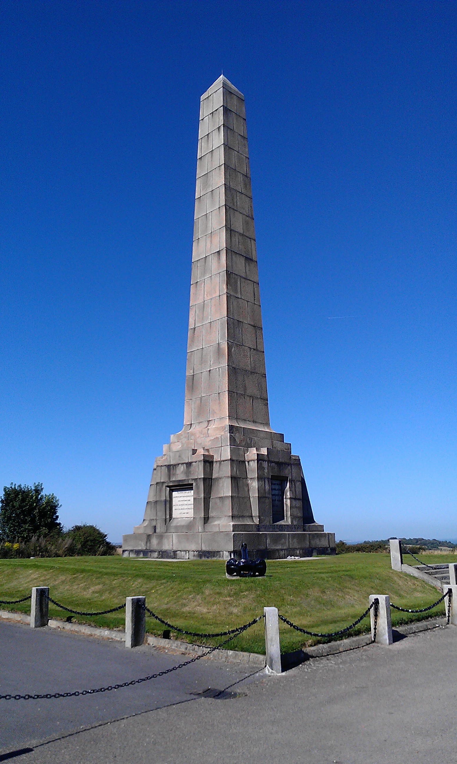
![A walk from St Margaretâs at Cliffe to Kingsdown and return [1] This monument at Leathercoat Point was erected in 1921 as a memorial to the Dover Patrol in WWI. There are identical monuments in France and in New York. Constructed of ashlar blocks, about 80 feet high. Listed, grade II*, with details at: historicengland.org.uk/listing/the-list/list-entry/1070067
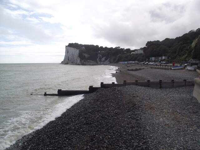
Starting from the Dover Patrol Monument, the walk follows the long distance Saxon Shore Way along the top of the cliffs before descending to the bay at Kingsdown. Heading inland there is an ascent of Wood Hill before various rights of way run across fields to the wonderfully named Otty Bottom, then on to Free Down and a return to the starting point. A little more than 5 miles.](https://s0.geograph.org.uk/geophotos/07/08/49/7084960_5fb94790.jpg)
![A walk from St Margaretâs at Cliffe to Kingsdown and return [2] The path heads north along the cliff tops. From here to Kingsdown the path is part of three long distance paths. The England Coast Path, the Saxon Shore Way and the White Cliffs Country Trail.
Starting from the Dover Patrol Monument, the walk follows the long distance Saxon Shore Way along the top of the cliffs before descending to the bay at Kingsdown. Heading inland there is an ascent of Wood Hill before various rights of way run across fields to the wonderfully named Otty Bottom, then on to Free Down and a return to the starting point. A little more than 5 miles.](https://s1.geograph.org.uk/geophotos/07/08/49/7084961_ffab8a6a.jpg)
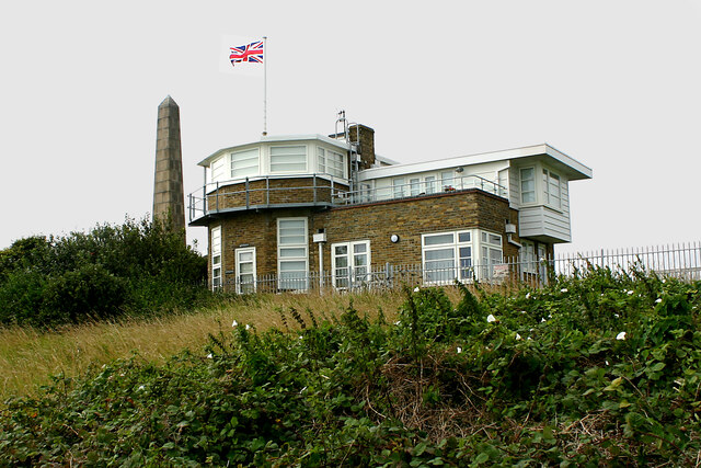
![A walk from St Margaretâs at Cliffe to Kingsdown and return [3] This building appears to be a coastal lookout. On the OS map it is marked as a tearoom.
Starting from the Dover Patrol Monument, the walk follows the long distance Saxon Shore Way along the top of the cliffs before descending to the bay at Kingsdown. Heading inland there is an ascent of Wood Hill before various rights of way run across fields to the wonderfully named Otty Bottom, then on to Free Down and a return to the starting point. A little more than 5 miles.](https://s3.geograph.org.uk/geophotos/07/08/49/7084963_3f47163f.jpg)
![A walk from St Margaretâs at Cliffe to Kingsdown and return [4] North along the cliff top.
Starting from the Dover Patrol Monument, the walk follows the long distance Saxon Shore Way along the top of the cliffs before descending to the bay at Kingsdown. Heading inland there is an ascent of Wood Hill before various rights of way run across fields to the wonderfully named Otty Bottom, then on to Free Down and a return to the starting point. A little more than 5 miles.](https://s0.geograph.org.uk/geophotos/07/08/49/7084964_33d23893.jpg)
![A walk from St Margaretâs at Cliffe to Kingsdown and return [49] The view looking southwest from the track. The twin towers of the transmitting station at Dover are seen in the far distance.
Starting from the Dover Patrol Monument, the walk follows the long distance Saxon Shore Way along the top of the cliffs before descending to the bay at Kingsdown. Heading inland there is an ascent of Wood Hill before various rights of way run across fields to the wonderfully named Otty Bottom, then on to Free Down and a return to the starting point. A little more than 5 miles.](https://s2.geograph.org.uk/geophotos/07/08/62/7086234_feaa026b.jpg)
![A walk from St Margaretâs at Cliffe to Kingsdown and return [50] From the track, this footpath leads to St Margaret's Free Down.
Starting from the Dover Patrol Monument, the walk follows the long distance Saxon Shore Way along the top of the cliffs before descending to the bay at Kingsdown. Heading inland there is an ascent of Wood Hill before various rights of way run across fields to the wonderfully named Otty Bottom, then on to Free Down and a return to the starting point. A little more than 5 miles.](https://s3.geograph.org.uk/geophotos/07/08/62/7086235_67b7386f.jpg)
![A walk from St Margaretâs at Cliffe to Kingsdown and return [51] From the bridleway, this footpath runs to Old Bottom Free Down then on to Ringwould.
Starting from the Dover Patrol Monument, the walk follows the long distance Saxon Shore Way along the top of the cliffs before descending to the bay at Kingsdown. Heading inland there is an ascent of Wood Hill before various rights of way run across fields to the wonderfully named Otty Bottom, then on to Free Down and a return to the starting point. A little more than 5 miles.](https://s0.geograph.org.uk/geophotos/07/08/68/7086844_588697a9.jpg)
![A walk from St Margaretâs at Cliffe to Kingsdown and return [52] From the track, a public bridleway, this track leads to Little Banks.
Starting from the Dover Patrol Monument, the walk follows the long distance Saxon Shore Way along the top of the cliffs before descending to the bay at Kingsdown. Heading inland there is an ascent of Wood Hill before various rights of way run across fields to the wonderfully named Otty Bottom, then on to Free Down and a return to the starting point. A little more than 5 miles.](https://s1.geograph.org.uk/geophotos/07/08/68/7086845_349942ee.jpg)
![A walk from St Margaretâs at Cliffe to Kingsdown and return [53] The well surfaced track, now an 'other route with public access', continues to head towards Free Down.
Starting from the Dover Patrol Monument, the walk follows the long distance Saxon Shore Way along the top of the cliffs before descending to the bay at Kingsdown. Heading inland there is an ascent of Wood Hill before various rights of way run across fields to the wonderfully named Otty Bottom, then on to Free Down and a return to the starting point. A little more than 5 miles.](https://s2.geograph.org.uk/geophotos/07/08/68/7086846_cb6d6b13.jpg)
![A walk from St Margaretâs at Cliffe to Kingsdown and return [54] This footpath leaves the track and heads towards Bockell Hill.
Starting from the Dover Patrol Monument, the walk follows the long distance Saxon Shore Way along the top of the cliffs before descending to the bay at Kingsdown. Heading inland there is an ascent of Wood Hill before various rights of way run across fields to the wonderfully named Otty Bottom, then on to Free Down and a return to the starting point. A little more than 5 miles.](https://s3.geograph.org.uk/geophotos/07/08/68/7086847_66b904e3.jpg)
![A walk from St Margaretâs at Cliffe to Kingsdown and return [55] A view back along the track, seen from where the footpath to Bockell Hill branches off.
Starting from the Dover Patrol Monument, the walk follows the long distance Saxon Shore Way along the top of the cliffs before descending to the bay at Kingsdown. Heading inland there is an ascent of Wood Hill before various rights of way run across fields to the wonderfully named Otty Bottom, then on to Free Down and a return to the starting point. A little more than 5 miles.](https://s0.geograph.org.uk/geophotos/07/08/68/7086848_95fa9eda.jpg)
![A walk from St Margaretâs at Cliffe to Kingsdown and return [56] A view along the track, seen from where the footpath to Bockell Hill branches off.
Starting from the Dover Patrol Monument, the walk follows the long distance Saxon Shore Way along the top of the cliffs before descending to the bay at Kingsdown. Heading inland there is an ascent of Wood Hill before various rights of way run across fields to the wonderfully named Otty Bottom, then on to Free Down and a return to the starting point. A little more than 5 miles.](https://s1.geograph.org.uk/geophotos/07/08/68/7086849_4eb9e9ff.jpg)
![A walk from St Margaretâs at Cliffe to Kingsdown and return [57] The foot descends towards Bockell Hill through this area of woodland.
Starting from the Dover Patrol Monument, the walk follows the long distance Saxon Shore Way along the top of the cliffs before descending to the bay at Kingsdown. Heading inland there is an ascent of Wood Hill before various rights of way run across fields to the wonderfully named Otty Bottom, then on to Free Down and a return to the starting point. A little more than 5 miles.](https://s2.geograph.org.uk/geophotos/07/08/68/7086850_62f7cc05.jpg)
![A walk from St Margaretâs at Cliffe to Kingsdown and return [58] After passing through woodland, the path to Bockell Hill emerges into open fields.
Starting from the Dover Patrol Monument, the walk follows the long distance Saxon Shore Way along the top of the cliffs before descending to the bay at Kingsdown. Heading inland there is an ascent of Wood Hill before various rights of way run across fields to the wonderfully named Otty Bottom, then on to Free Down and a return to the starting point. A little more than 5 miles.](https://s3.geograph.org.uk/geophotos/07/08/68/7086851_b6420cae.jpg)
Bay Hill is located at Grid Ref: TR3644 (Lat: 51.14894, Lng: 1.3736871)
Administrative County: Kent
District: Dover
Police Authority: Kent
What 3 Words
///hometown.forget.duties. Near Dover, Kent
Nearby Locations
Related Wikis

Dover to Kingsdown Cliffs
Dover to Kingsdown Cliffs is a 207.7-hectare (513-acre) biological and geological Site of Special Scientific Interest which runs along the Kent coast between...

St Margaret's at Cliffe
St. Margaret's at Cliffe is a three-part village situated just off the coast road between Deal and Dover in Kent, England. The centre of the village is...

South Foreland
South Foreland is a chalk headland on the Kent coast of southeast England. It presents a bold cliff to the sea, and commands views over the Strait of Dover...

St Margaret's Bay Windmill
St Margaret's Bay Windmill is a Grade II listed Smock mill on South Foreland, the southeasternmost point of England. It was built in 1929 to generate electricity...

White Cliffs of Dover
The White Cliffs of Dover are the region of English coastline facing the Strait of Dover and France. The cliff face, which reaches a height of 350 feet...

West Cliffe
West Cliffe or Westcliffe is a village and former civil parish, now in the parish of St. Margaret's At Cliffe, in the Dover district, in east Kent, England...
Dover Patrol
The Dover Patrol and later known as the Dover Patrol Force was a Royal Navy command of the First World War, notable for its involvement in the Zeebrugge...
Leathercoat Point
Leathercoat Point is a landform in St Margaret's at Cliffe, Kent. The Dover Patrol Monument is located here. == References ==
Nearby Amenities
Located within 500m of 51.14894,1.3736871Have you been to Bay Hill?
Leave your review of Bay Hill below (or comments, questions and feedback).