Ness Point
Coastal Feature, Headland, Point in Kent Dover
England
Ness Point
Ness Point is a prominent coastal feature located in Kent, England. Situated on the easternmost tip of the county, it is known as the most easterly point in the entire United Kingdom. This headland juts out into the North Sea, marking the end of the landmass before the vast expanse of water.
The point itself is characterized by its rugged beauty and natural splendor. It boasts towering cliffs, which have been eroded over time by the relentless force of the sea. The cliffs are composed of various geological formations, including chalk, limestone, and sandstone, providing a diverse and visually stunning landscape.
Ness Point offers breathtaking panoramic views of the surrounding coastline, with unobstructed vistas of the North Sea stretching out as far as the eye can see. On a clear day, it is possible to catch a glimpse of the distant shores of Belgium and the Netherlands, enhancing its allure as a visitor destination.
In addition to its natural beauty, Ness Point holds historical significance. It is the starting point of the England Coast Path, a long-distance footpath that traces the entire coastline of England. This makes it a popular spot for hikers and nature enthusiasts, who can embark on scenic walks along the coast, exploring the diverse flora and fauna that inhabit the area.
Overall, Ness Point in Kent is a captivating coastal feature that combines stunning natural surroundings with historical importance. Whether it's for leisurely walks, photography, or simply enjoying the breathtaking views, this headland offers an unforgettable experience for visitors.
If you have any feedback on the listing, please let us know in the comments section below.
Ness Point Images
Images are sourced within 2km of 51.148619/1.3847619 or Grid Reference TR3644. Thanks to Geograph Open Source API. All images are credited.
![A walk from St Margaretâs at Cliffe to Kingsdown and return [1] This monument at Leathercoat Point was erected in 1921 as a memorial to the Dover Patrol in WWI. There are identical monuments in France and in New York. Constructed of ashlar blocks, about 80 feet high. Listed, grade II*, with details at: historicengland.org.uk/listing/the-list/list-entry/1070067
Starting from the Dover Patrol Monument, the walk follows the long distance Saxon Shore Way along the top of the cliffs before descending to the bay at Kingsdown. Heading inland there is an ascent of Wood Hill before various rights of way run across fields to the wonderfully named Otty Bottom, then on to Free Down and a return to the starting point. A little more than 5 miles.](https://s0.geograph.org.uk/geophotos/07/08/49/7084960_5fb94790.jpg)
![A walk from St Margaretâs at Cliffe to Kingsdown and return [2] The path heads north along the cliff tops. From here to Kingsdown the path is part of three long distance paths. The England Coast Path, the Saxon Shore Way and the White Cliffs Country Trail.
Starting from the Dover Patrol Monument, the walk follows the long distance Saxon Shore Way along the top of the cliffs before descending to the bay at Kingsdown. Heading inland there is an ascent of Wood Hill before various rights of way run across fields to the wonderfully named Otty Bottom, then on to Free Down and a return to the starting point. A little more than 5 miles.](https://s1.geograph.org.uk/geophotos/07/08/49/7084961_ffab8a6a.jpg)
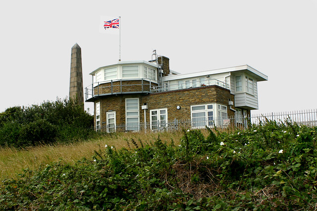
![A walk from St Margaretâs at Cliffe to Kingsdown and return [3] This building appears to be a coastal lookout. On the OS map it is marked as a tearoom.
Starting from the Dover Patrol Monument, the walk follows the long distance Saxon Shore Way along the top of the cliffs before descending to the bay at Kingsdown. Heading inland there is an ascent of Wood Hill before various rights of way run across fields to the wonderfully named Otty Bottom, then on to Free Down and a return to the starting point. A little more than 5 miles.](https://s3.geograph.org.uk/geophotos/07/08/49/7084963_3f47163f.jpg)
![A walk from St Margaretâs at Cliffe to Kingsdown and return [4] North along the cliff top.
Starting from the Dover Patrol Monument, the walk follows the long distance Saxon Shore Way along the top of the cliffs before descending to the bay at Kingsdown. Heading inland there is an ascent of Wood Hill before various rights of way run across fields to the wonderfully named Otty Bottom, then on to Free Down and a return to the starting point. A little more than 5 miles.](https://s0.geograph.org.uk/geophotos/07/08/49/7084964_33d23893.jpg)
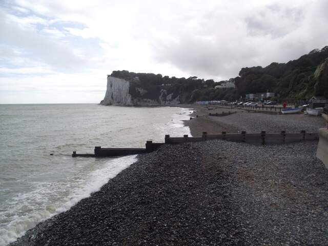
![A walk from St Margaretâs at Cliffe to Kingsdown and return [5] Looking north from the path and the first glimpse of white chalk.
Starting from the Dover Patrol Monument, the walk follows the long distance Saxon Shore Way along the top of the cliffs before descending to the bay at Kingsdown. Heading inland there is an ascent of Wood Hill before various rights of way run across fields to the wonderfully named Otty Bottom, then on to Free Down and a return to the starting point. A little more than 5 miles.](https://s1.geograph.org.uk/geophotos/07/08/49/7084965_f29314bb.jpg)
![A walk from St Margaretâs at Cliffe to Kingsdown and return [6] The path continues to head north along the cliff tops. From here to Kingsdown the path is part of three long distance paths. The England Coast Path, the Saxon Shore Way and the White Cliffs Country Trail.
Starting from the Dover Patrol Monument, the walk follows the long distance Saxon Shore Way along the top of the cliffs before descending to the bay at Kingsdown. Heading inland there is an ascent of Wood Hill before various rights of way run across fields to the wonderfully named Otty Bottom, then on to Free Down and a return to the starting point. A little more than 5 miles.](https://s2.geograph.org.uk/geophotos/07/08/49/7084966_a91838df.jpg)
![A walk from St Margaretâs at Cliffe to Kingsdown and return [7] A view back along the path with the Dover Patrol Monument prominent.
Starting from the Dover Patrol Monument, the walk follows the long distance Saxon Shore Way along the top of the cliffs before descending to the bay at Kingsdown. Heading inland there is an ascent of Wood Hill before various rights of way run across fields to the wonderfully named Otty Bottom, then on to Free Down and a return to the starting point. A little more than 5 miles.](https://s3.geograph.org.uk/geophotos/07/08/49/7084967_1b69f27a.jpg)
![A walk from St Margaretâs at Cliffe to Kingsdown and return [8] From the cliff top path, this path branches off and leads to St Margaret's Free Down.
Starting from the Dover Patrol Monument, the walk follows the long distance Saxon Shore Way along the top of the cliffs before descending to the bay at Kingsdown. Heading inland there is an ascent of Wood Hill before various rights of way run across fields to the wonderfully named Otty Bottom, then on to Free Down and a return to the starting point. A little more than 5 miles.](https://s2.geograph.org.uk/geophotos/07/08/49/7084970_96d30c90.jpg)
![A walk from St Margaretâs at Cliffe to Kingsdown and return [48] The track, a public bridleway, continues to ascend gently towards Freedown.
Starting from the Dover Patrol Monument, the walk follows the long distance Saxon Shore Way along the top of the cliffs before descending to the bay at Kingsdown. Heading inland there is an ascent of Wood Hill before various rights of way run across fields to the wonderfully named Otty Bottom, then on to Free Down and a return to the starting point. A little more than 5 miles.](https://s1.geograph.org.uk/geophotos/07/08/62/7086233_1073c389.jpg)
![A walk from St Margaretâs at Cliffe to Kingsdown and return [49] The view looking southwest from the track. The twin towers of the transmitting station at Dover are seen in the far distance.
Starting from the Dover Patrol Monument, the walk follows the long distance Saxon Shore Way along the top of the cliffs before descending to the bay at Kingsdown. Heading inland there is an ascent of Wood Hill before various rights of way run across fields to the wonderfully named Otty Bottom, then on to Free Down and a return to the starting point. A little more than 5 miles.](https://s2.geograph.org.uk/geophotos/07/08/62/7086234_feaa026b.jpg)
![A walk from St Margaretâs at Cliffe to Kingsdown and return [50] From the track, this footpath leads to St Margaret's Free Down.
Starting from the Dover Patrol Monument, the walk follows the long distance Saxon Shore Way along the top of the cliffs before descending to the bay at Kingsdown. Heading inland there is an ascent of Wood Hill before various rights of way run across fields to the wonderfully named Otty Bottom, then on to Free Down and a return to the starting point. A little more than 5 miles.](https://s3.geograph.org.uk/geophotos/07/08/62/7086235_67b7386f.jpg)
![A walk from St Margaretâs at Cliffe to Kingsdown and return [51] From the bridleway, this footpath runs to Old Bottom Free Down then on to Ringwould.
Starting from the Dover Patrol Monument, the walk follows the long distance Saxon Shore Way along the top of the cliffs before descending to the bay at Kingsdown. Heading inland there is an ascent of Wood Hill before various rights of way run across fields to the wonderfully named Otty Bottom, then on to Free Down and a return to the starting point. A little more than 5 miles.](https://s0.geograph.org.uk/geophotos/07/08/68/7086844_588697a9.jpg)
![A walk from St Margaretâs at Cliffe to Kingsdown and return [52] From the track, a public bridleway, this track leads to Little Banks.
Starting from the Dover Patrol Monument, the walk follows the long distance Saxon Shore Way along the top of the cliffs before descending to the bay at Kingsdown. Heading inland there is an ascent of Wood Hill before various rights of way run across fields to the wonderfully named Otty Bottom, then on to Free Down and a return to the starting point. A little more than 5 miles.](https://s1.geograph.org.uk/geophotos/07/08/68/7086845_349942ee.jpg)
![A walk from St Margaretâs at Cliffe to Kingsdown and return [53] The well surfaced track, now an 'other route with public access', continues to head towards Free Down.
Starting from the Dover Patrol Monument, the walk follows the long distance Saxon Shore Way along the top of the cliffs before descending to the bay at Kingsdown. Heading inland there is an ascent of Wood Hill before various rights of way run across fields to the wonderfully named Otty Bottom, then on to Free Down and a return to the starting point. A little more than 5 miles.](https://s2.geograph.org.uk/geophotos/07/08/68/7086846_cb6d6b13.jpg)
Ness Point is located at Grid Ref: TR3644 (Lat: 51.148619, Lng: 1.3847619)
Administrative County: Kent
District: Dover
Police Authority: Kent
What 3 Words
///materials.clicker.upsetting. Near Dover, Kent
Nearby Locations
Related Wikis

St Margaret's Bay Windmill
St Margaret's Bay Windmill is a Grade II listed Smock mill on South Foreland, the southeasternmost point of England. It was built in 1929 to generate electricity...

South Foreland
South Foreland is a chalk headland on the Kent coast of southeast England. It presents a bold cliff to the sea, and commands views over the Strait of Dover...

Dover to Kingsdown Cliffs
Dover to Kingsdown Cliffs is a 207.7-hectare (513-acre) biological and geological Site of Special Scientific Interest which runs along the Kent coast between...

St Margaret's at Cliffe
St. Margaret's at Cliffe is a three-part village situated just off the coast road between Deal and Dover in Kent, England. The centre of the village is...
Nearby Amenities
Located within 500m of 51.148619,1.3847619Have you been to Ness Point?
Leave your review of Ness Point below (or comments, questions and feedback).