Madges Wood
Wood, Forest in Kent Dover
England
Madges Wood
Madges Wood is a beautiful woodland located in the county of Kent, England. Situated near the village of Bilsington, it covers an area of approximately 50 acres and is known for its diverse range of flora and fauna.
The wood is predominantly made up of deciduous trees, including oak, beech, and ash, creating a lush and green environment throughout the year. The forest floor is covered in a carpet of wildflowers, such as bluebells and primroses, which bloom in spring, adding a burst of color to the woodland.
Madges Wood is home to a variety of wildlife, making it a popular spot for nature enthusiasts and birdwatchers. Bird species that can be spotted here include great spotted woodpeckers, tawny owls, and nuthatches. The wood is also inhabited by small mammals like badgers, foxes, and hedgehogs.
The woodland is well-maintained, with a network of well-marked footpaths and trails, allowing visitors to explore the area easily. There is also a picnic area where visitors can relax and enjoy the tranquil surroundings.
Madges Wood is a designated Site of Special Scientific Interest (SSSI) due to its importance for conservation and biodiversity. It is managed by a local conservation trust, which ensures the preservation of the woodland's unique ecosystem.
Overall, Madges Wood offers a peaceful and picturesque setting for nature lovers to immerse themselves in the beauty of Kent's countryside.
If you have any feedback on the listing, please let us know in the comments section below.
Madges Wood Images
Images are sourced within 2km of 51.153318/1.37907 or Grid Reference TR3644. Thanks to Geograph Open Source API. All images are credited.
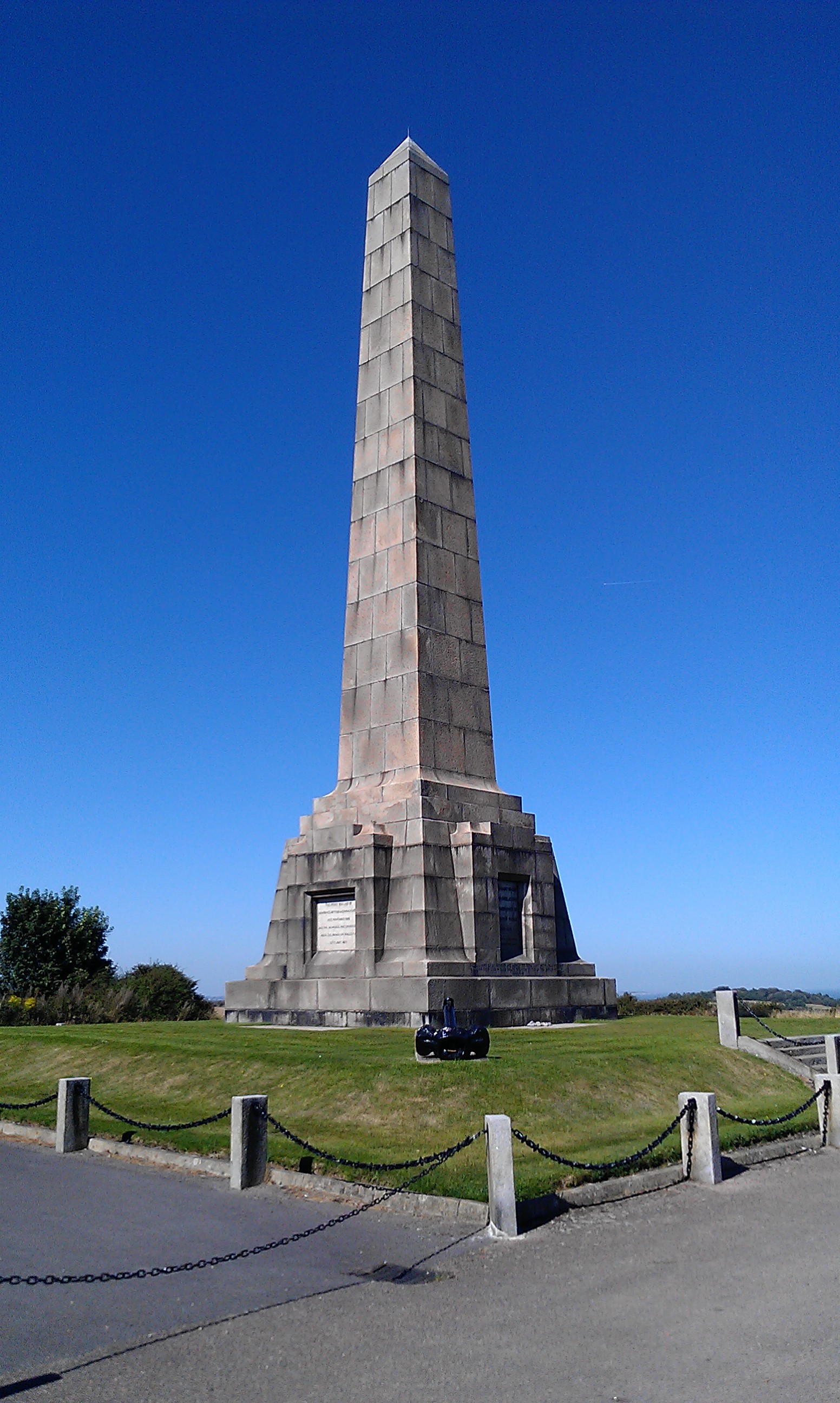
![A walk from St Margaretâs at Cliffe to Kingsdown and return [1] This monument at Leathercoat Point was erected in 1921 as a memorial to the Dover Patrol in WWI. There are identical monuments in France and in New York. Constructed of ashlar blocks, about 80 feet high. Listed, grade II*, with details at: historicengland.org.uk/listing/the-list/list-entry/1070067
Starting from the Dover Patrol Monument, the walk follows the long distance Saxon Shore Way along the top of the cliffs before descending to the bay at Kingsdown. Heading inland there is an ascent of Wood Hill before various rights of way run across fields to the wonderfully named Otty Bottom, then on to Free Down and a return to the starting point. A little more than 5 miles.](https://s0.geograph.org.uk/geophotos/07/08/49/7084960_5fb94790.jpg)
![A walk from St Margaretâs at Cliffe to Kingsdown and return [2] The path heads north along the cliff tops. From here to Kingsdown the path is part of three long distance paths. The England Coast Path, the Saxon Shore Way and the White Cliffs Country Trail.
Starting from the Dover Patrol Monument, the walk follows the long distance Saxon Shore Way along the top of the cliffs before descending to the bay at Kingsdown. Heading inland there is an ascent of Wood Hill before various rights of way run across fields to the wonderfully named Otty Bottom, then on to Free Down and a return to the starting point. A little more than 5 miles.](https://s1.geograph.org.uk/geophotos/07/08/49/7084961_ffab8a6a.jpg)
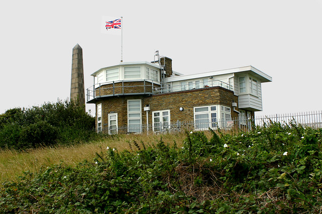
![A walk from St Margaretâs at Cliffe to Kingsdown and return [3] This building appears to be a coastal lookout. On the OS map it is marked as a tearoom.
Starting from the Dover Patrol Monument, the walk follows the long distance Saxon Shore Way along the top of the cliffs before descending to the bay at Kingsdown. Heading inland there is an ascent of Wood Hill before various rights of way run across fields to the wonderfully named Otty Bottom, then on to Free Down and a return to the starting point. A little more than 5 miles.](https://s3.geograph.org.uk/geophotos/07/08/49/7084963_3f47163f.jpg)
![A walk from St Margaretâs at Cliffe to Kingsdown and return [4] North along the cliff top.
Starting from the Dover Patrol Monument, the walk follows the long distance Saxon Shore Way along the top of the cliffs before descending to the bay at Kingsdown. Heading inland there is an ascent of Wood Hill before various rights of way run across fields to the wonderfully named Otty Bottom, then on to Free Down and a return to the starting point. A little more than 5 miles.](https://s0.geograph.org.uk/geophotos/07/08/49/7084964_33d23893.jpg)
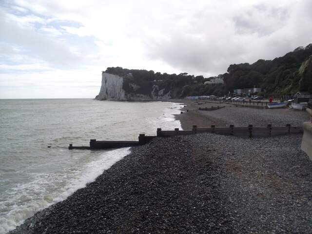
![A walk from St Margaretâs at Cliffe to Kingsdown and return [5] Looking north from the path and the first glimpse of white chalk.
Starting from the Dover Patrol Monument, the walk follows the long distance Saxon Shore Way along the top of the cliffs before descending to the bay at Kingsdown. Heading inland there is an ascent of Wood Hill before various rights of way run across fields to the wonderfully named Otty Bottom, then on to Free Down and a return to the starting point. A little more than 5 miles.](https://s1.geograph.org.uk/geophotos/07/08/49/7084965_f29314bb.jpg)
![A walk from St Margaretâs at Cliffe to Kingsdown and return [6] The path continues to head north along the cliff tops. From here to Kingsdown the path is part of three long distance paths. The England Coast Path, the Saxon Shore Way and the White Cliffs Country Trail.
Starting from the Dover Patrol Monument, the walk follows the long distance Saxon Shore Way along the top of the cliffs before descending to the bay at Kingsdown. Heading inland there is an ascent of Wood Hill before various rights of way run across fields to the wonderfully named Otty Bottom, then on to Free Down and a return to the starting point. A little more than 5 miles.](https://s2.geograph.org.uk/geophotos/07/08/49/7084966_a91838df.jpg)
![A walk from St Margaretâs at Cliffe to Kingsdown and return [7] A view back along the path with the Dover Patrol Monument prominent.
Starting from the Dover Patrol Monument, the walk follows the long distance Saxon Shore Way along the top of the cliffs before descending to the bay at Kingsdown. Heading inland there is an ascent of Wood Hill before various rights of way run across fields to the wonderfully named Otty Bottom, then on to Free Down and a return to the starting point. A little more than 5 miles.](https://s3.geograph.org.uk/geophotos/07/08/49/7084967_1b69f27a.jpg)
![A walk from St Margaretâs at Cliffe to Kingsdown and return [8] From the cliff top path, this path branches off and leads to St Margaret's Free Down.
Starting from the Dover Patrol Monument, the walk follows the long distance Saxon Shore Way along the top of the cliffs before descending to the bay at Kingsdown. Heading inland there is an ascent of Wood Hill before various rights of way run across fields to the wonderfully named Otty Bottom, then on to Free Down and a return to the starting point. A little more than 5 miles.](https://s2.geograph.org.uk/geophotos/07/08/49/7084970_96d30c90.jpg)
![A walk from St Margaretâs at Cliffe to Kingsdown and return [41] From here the line of the bridleway runs straight across to the corner of this field. The line of the right of way has not been re-established after ploughing and an alternative route along the field edge is offered - see <a href="https://www.geograph.org.uk/photo/7086227">TR3646 : A walk from St Margaret&rsquo;s at Cliffe to Kingsdown and return [42]</a>. For the reverse view of this image see <a href="https://www.geograph.org.uk/photo/7086230">TR3646 : A walk from St Margaret&rsquo;s at Cliffe to Kingsdown and return [45]</a>.
Starting from the Dover Patrol Monument, the walk follows the long distance Saxon Shore Way along the top of the cliffs before descending to the bay at Kingsdown. Heading inland there is an ascent of Wood Hill before various rights of way run across fields to the wonderfully named Otty Bottom, then on to Free Down and a return to the starting point. A little more than 5 miles.](https://s2.geograph.org.uk/geophotos/07/08/62/7086226_fc2cdda3.jpg)
![A walk from St Margaretâs at Cliffe to Kingsdown and return [42] From the same viewpoint as <a href="https://www.geograph.org.uk/photo/7086226">TR3646 : A walk from St Margaret&rsquo;s at Cliffe to Kingsdown and return [41]</a> this is the alternative route along the field edge to the track between the hedges. The golf course on East Hill is in the distance.
Starting from the Dover Patrol Monument, the walk follows the long distance Saxon Shore Way along the top of the cliffs before descending to the bay at Kingsdown. Heading inland there is an ascent of Wood Hill before various rights of way run across fields to the wonderfully named Otty Bottom, then on to Free Down and a return to the starting point. A little more than 5 miles.](https://s3.geograph.org.uk/geophotos/07/08/62/7086227_cd12a75c.jpg)
![A walk from St Margaretâs at Cliffe to Kingsdown and return [43] The bridleway now follows the well surfaced track towards Upper Freedown.
Starting from the Dover Patrol Monument, the walk follows the long distance Saxon Shore Way along the top of the cliffs before descending to the bay at Kingsdown. Heading inland there is an ascent of Wood Hill before various rights of way run across fields to the wonderfully named Otty Bottom, then on to Free Down and a return to the starting point. A little more than 5 miles.](https://s0.geograph.org.uk/geophotos/07/08/62/7086228_6335abe3.jpg)
![A walk from St Margaretâs at Cliffe to Kingsdown and return [44] A view back along the track, a public bridleway, looking towards Kingsdown.
Starting from the Dover Patrol Monument, the walk follows the long distance Saxon Shore Way along the top of the cliffs before descending to the bay at Kingsdown. Heading inland there is an ascent of Wood Hill before various rights of way run across fields to the wonderfully named Otty Bottom, then on to Free Down and a return to the starting point. A little more than 5 miles.](https://s1.geograph.org.uk/geophotos/07/08/62/7086229_aca74dd5.jpg)
![A walk from St Margaretâs at Cliffe to Kingsdown and return [45] This is the reverse view of <a href="https://www.geograph.org.uk/photo/7086226">TR3646 : A walk from St Margaret&rsquo;s at Cliffe to Kingsdown and return [41]</a> and is where the right of way would meet the track. However, the bridleway has not been re-established after ploughing, and an alternative route has been used.
Starting from the Dover Patrol Monument, the walk follows the long distance Saxon Shore Way along the top of the cliffs before descending to the bay at Kingsdown. Heading inland there is an ascent of Wood Hill before various rights of way run across fields to the wonderfully named Otty Bottom, then on to Free Down and a return to the starting point. A little more than 5 miles.](https://s2.geograph.org.uk/geophotos/07/08/62/7086230_17cbc437.jpg)
![A walk from St Margaretâs at Cliffe to Kingsdown and return [46] Posts have been erected across the track, a public bridleway, to prevent vehicles passing beyond this point.
Starting from the Dover Patrol Monument, the walk follows the long distance Saxon Shore Way along the top of the cliffs before descending to the bay at Kingsdown. Heading inland there is an ascent of Wood Hill before various rights of way run across fields to the wonderfully named Otty Bottom, then on to Free Down and a return to the starting point. A little more than 5 miles.](https://s3.geograph.org.uk/geophotos/07/08/62/7086231_4041273d.jpg)
Madges Wood is located at Grid Ref: TR3644 (Lat: 51.153318, Lng: 1.37907)
Administrative County: Kent
District: Dover
Police Authority: Kent
What 3 Words
///paddocks.trample.crib. Near Dover, Kent
Nearby Locations
Related Wikis

St Margaret's at Cliffe
St. Margaret's at Cliffe is a three-part village situated just off the coast road between Deal and Dover in Kent, England. The centre of the village is...

Dover to Kingsdown Cliffs
Dover to Kingsdown Cliffs is a 207.7-hectare (513-acre) biological and geological Site of Special Scientific Interest which runs along the Kent coast between...
Dover Patrol
The Dover Patrol and later known as the Dover Patrol Force was a Royal Navy command of the First World War, notable for its involvement in the Zeebrugge...

Leathercoat Point
Leathercoat Point is a landform in St Margaret's at Cliffe, Kent. The Dover Patrol Monument is located here. == References ==

South Foreland
South Foreland is a chalk headland on the Kent coast of southeast England. It presents a bold cliff to the sea, and commands views over the Strait of Dover...
St Margaret's Bay Windmill
St Margaret's Bay Windmill is a Grade II listed Smock mill on South Foreland, the southeasternmost point of England. It was built in 1929 to generate electricity...

West Cliffe
West Cliffe or Westcliffe is a village and former civil parish, now in the parish of St. Margaret's At Cliffe, in the Dover district, in east Kent, England...

White Cliffs of Dover
The White Cliffs of Dover are the region of English coastline facing the Strait of Dover and France. The cliff face, which reaches a height of 350 feet...
Nearby Amenities
Located within 500m of 51.153318,1.37907Have you been to Madges Wood?
Leave your review of Madges Wood below (or comments, questions and feedback).