Bockell Hill
Hill, Mountain in Kent Dover
England
Bockell Hill
Bockell Hill is a prominent hill located in the county of Kent, England. Situated near the village of Charing, it forms part of the North Downs, a range of chalk hills that stretch across southeast England. Rising to a height of approximately 235 meters (771 feet), it stands as one of the highest points in the region, offering stunning panoramic views of the surrounding countryside.
Covered in lush greenery and dotted with trees, Bockell Hill boasts a diverse range of flora and fauna, making it a popular spot for nature enthusiasts and hikers. The hill is home to a variety of wildlife, including birds, butterflies, and small mammals, adding to its natural charm.
The summit of Bockell Hill is crowned by an ancient burial mound, believed to be of Roman origin. This archaeological feature adds historical significance to the area, attracting those interested in the region's past. The hill itself has a long history, with evidence of human activity dating back thousands of years.
Access to Bockell Hill is provided by footpaths and bridleways, allowing visitors to explore its scenic beauty and soak in the tranquil countryside atmosphere. The hill is a favorite destination for walkers, who can enjoy the breathtaking views and the peaceful surroundings.
Overall, Bockell Hill in Kent is a captivating natural landmark that combines stunning views, diverse wildlife, and historical significance, making it a must-visit location for both locals and tourists alike.
If you have any feedback on the listing, please let us know in the comments section below.
Bockell Hill Images
Images are sourced within 2km of 51.15489/1.3862939 or Grid Reference TR3644. Thanks to Geograph Open Source API. All images are credited.
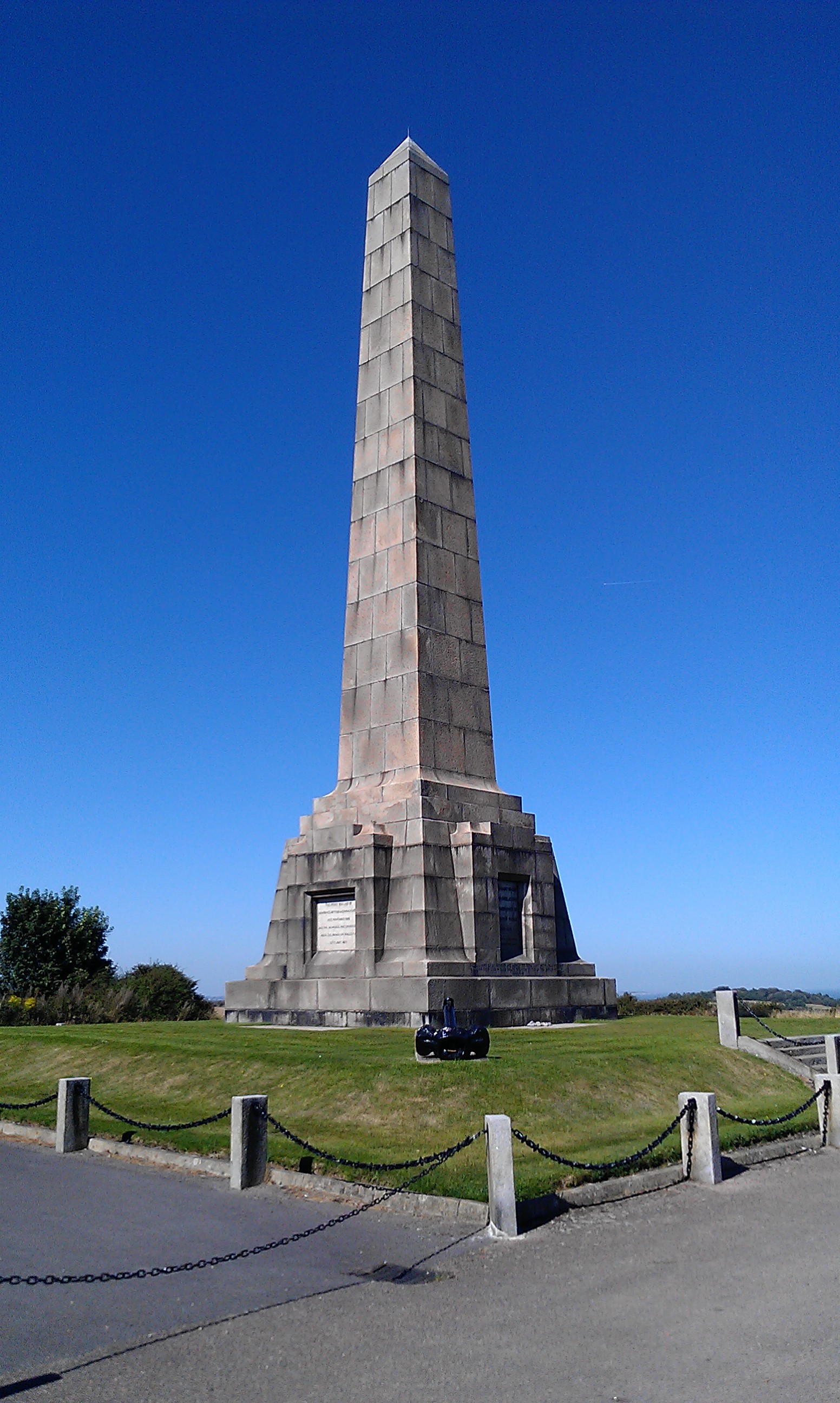
![A walk from St Margaretâs at Cliffe to Kingsdown and return [1] This monument at Leathercoat Point was erected in 1921 as a memorial to the Dover Patrol in WWI. There are identical monuments in France and in New York. Constructed of ashlar blocks, about 80 feet high. Listed, grade II*, with details at: historicengland.org.uk/listing/the-list/list-entry/1070067
Starting from the Dover Patrol Monument, the walk follows the long distance Saxon Shore Way along the top of the cliffs before descending to the bay at Kingsdown. Heading inland there is an ascent of Wood Hill before various rights of way run across fields to the wonderfully named Otty Bottom, then on to Free Down and a return to the starting point. A little more than 5 miles.](https://s0.geograph.org.uk/geophotos/07/08/49/7084960_5fb94790.jpg)
![A walk from St Margaretâs at Cliffe to Kingsdown and return [2] The path heads north along the cliff tops. From here to Kingsdown the path is part of three long distance paths. The England Coast Path, the Saxon Shore Way and the White Cliffs Country Trail.
Starting from the Dover Patrol Monument, the walk follows the long distance Saxon Shore Way along the top of the cliffs before descending to the bay at Kingsdown. Heading inland there is an ascent of Wood Hill before various rights of way run across fields to the wonderfully named Otty Bottom, then on to Free Down and a return to the starting point. A little more than 5 miles.](https://s1.geograph.org.uk/geophotos/07/08/49/7084961_ffab8a6a.jpg)
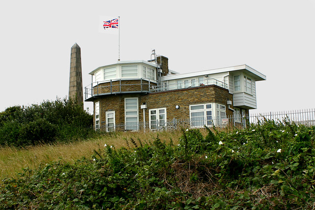
![A walk from St Margaretâs at Cliffe to Kingsdown and return [3] This building appears to be a coastal lookout. On the OS map it is marked as a tearoom.
Starting from the Dover Patrol Monument, the walk follows the long distance Saxon Shore Way along the top of the cliffs before descending to the bay at Kingsdown. Heading inland there is an ascent of Wood Hill before various rights of way run across fields to the wonderfully named Otty Bottom, then on to Free Down and a return to the starting point. A little more than 5 miles.](https://s3.geograph.org.uk/geophotos/07/08/49/7084963_3f47163f.jpg)
![A walk from St Margaretâs at Cliffe to Kingsdown and return [4] North along the cliff top.
Starting from the Dover Patrol Monument, the walk follows the long distance Saxon Shore Way along the top of the cliffs before descending to the bay at Kingsdown. Heading inland there is an ascent of Wood Hill before various rights of way run across fields to the wonderfully named Otty Bottom, then on to Free Down and a return to the starting point. A little more than 5 miles.](https://s0.geograph.org.uk/geophotos/07/08/49/7084964_33d23893.jpg)
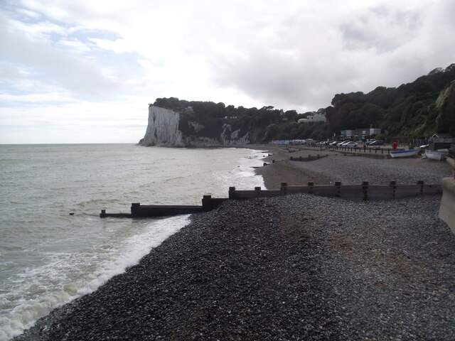
![A walk from St Margaretâs at Cliffe to Kingsdown and return [5] Looking north from the path and the first glimpse of white chalk.
Starting from the Dover Patrol Monument, the walk follows the long distance Saxon Shore Way along the top of the cliffs before descending to the bay at Kingsdown. Heading inland there is an ascent of Wood Hill before various rights of way run across fields to the wonderfully named Otty Bottom, then on to Free Down and a return to the starting point. A little more than 5 miles.](https://s1.geograph.org.uk/geophotos/07/08/49/7084965_f29314bb.jpg)
![A walk from St Margaretâs at Cliffe to Kingsdown and return [6] The path continues to head north along the cliff tops. From here to Kingsdown the path is part of three long distance paths. The England Coast Path, the Saxon Shore Way and the White Cliffs Country Trail.
Starting from the Dover Patrol Monument, the walk follows the long distance Saxon Shore Way along the top of the cliffs before descending to the bay at Kingsdown. Heading inland there is an ascent of Wood Hill before various rights of way run across fields to the wonderfully named Otty Bottom, then on to Free Down and a return to the starting point. A little more than 5 miles.](https://s2.geograph.org.uk/geophotos/07/08/49/7084966_a91838df.jpg)
![A walk from St Margaretâs at Cliffe to Kingsdown and return [7] A view back along the path with the Dover Patrol Monument prominent.
Starting from the Dover Patrol Monument, the walk follows the long distance Saxon Shore Way along the top of the cliffs before descending to the bay at Kingsdown. Heading inland there is an ascent of Wood Hill before various rights of way run across fields to the wonderfully named Otty Bottom, then on to Free Down and a return to the starting point. A little more than 5 miles.](https://s3.geograph.org.uk/geophotos/07/08/49/7084967_1b69f27a.jpg)
![A walk from St Margaretâs at Cliffe to Kingsdown and return [8] From the cliff top path, this path branches off and leads to St Margaret's Free Down.
Starting from the Dover Patrol Monument, the walk follows the long distance Saxon Shore Way along the top of the cliffs before descending to the bay at Kingsdown. Heading inland there is an ascent of Wood Hill before various rights of way run across fields to the wonderfully named Otty Bottom, then on to Free Down and a return to the starting point. A little more than 5 miles.](https://s2.geograph.org.uk/geophotos/07/08/49/7084970_96d30c90.jpg)
![A walk from St Margaretâs at Cliffe to Kingsdown and return [9] The path passes through the gate and offers glimpses of the white cliffs in the distance.
Starting from the Dover Patrol Monument, the walk follows the long distance Saxon Shore Way along the top of the cliffs before descending to the bay at Kingsdown. Heading inland there is an ascent of Wood Hill before various rights of way run across fields to the wonderfully named Otty Bottom, then on to Free Down and a return to the starting point. A little more than 5 miles.](https://s0.geograph.org.uk/geophotos/07/08/49/7084972_abb1dccf.jpg)
![A walk from St Margaretâs at Cliffe to Kingsdown and return [10] Seen from the path is this schooner.
Starting from the Dover Patrol Monument, the walk follows the long distance Saxon Shore Way along the top of the cliffs before descending to the bay at Kingsdown. Heading inland there is an ascent of Wood Hill before various rights of way run across fields to the wonderfully named Otty Bottom, then on to Free Down and a return to the starting point. A little more than 5 miles.](https://s1.geograph.org.uk/geophotos/07/08/49/7084973_923d3e8d.jpg)
![A walk from St Margaretâs at Cliffe to Kingsdown and return [11] The path continues north along the cliff top with the odd glimpse of the white chalk.
Starting from the Dover Patrol Monument, the walk follows the long distance Saxon Shore Way along the top of the cliffs before descending to the bay at Kingsdown. Heading inland there is an ascent of Wood Hill before various rights of way run across fields to the wonderfully named Otty Bottom, then on to Free Down and a return to the starting point. A little more than 5 miles.](https://s2.geograph.org.uk/geophotos/07/08/49/7084974_f6d65af9.jpg)
![A walk from St Margaretâs at Cliffe to Kingsdown and return [38] The bridleway follows the boundary between two fields.
Starting from the Dover Patrol Monument, the walk follows the long distance Saxon Shore Way along the top of the cliffs before descending to the bay at Kingsdown. Heading inland there is an ascent of Wood Hill before various rights of way run across fields to the wonderfully named Otty Bottom, then on to Free Down and a return to the starting point. A little more than 5 miles.](https://s3.geograph.org.uk/geophotos/07/08/62/7086223_93fe857e.jpg)
![A walk from St Margaretâs at Cliffe to Kingsdown and return [39] Looking towards the coast from the bridleway, the land rises to East Hill, home of the Walmer and Kingsdown Golf Club.
Starting from the Dover Patrol Monument, the walk follows the long distance Saxon Shore Way along the top of the cliffs before descending to the bay at Kingsdown. Heading inland there is an ascent of Wood Hill before various rights of way run across fields to the wonderfully named Otty Bottom, then on to Free Down and a return to the starting point. A little more than 5 miles.](https://s0.geograph.org.uk/geophotos/07/08/62/7086224_ebfa034e.jpg)
![A walk from St Margaretâs at Cliffe to Kingsdown and return [40] The bridleway now passes through a small area of woodland.
Starting from the Dover Patrol Monument, the walk follows the long distance Saxon Shore Way along the top of the cliffs before descending to the bay at Kingsdown. Heading inland there is an ascent of Wood Hill before various rights of way run across fields to the wonderfully named Otty Bottom, then on to Free Down and a return to the starting point. A little more than 5 miles.](https://s1.geograph.org.uk/geophotos/07/08/62/7086225_ce60758e.jpg)
Bockell Hill is located at Grid Ref: TR3644 (Lat: 51.15489, Lng: 1.3862939)
Administrative County: Kent
District: Dover
Police Authority: Kent
What 3 Words
///gazes.cheetahs.canines. Near Dover, Kent
Nearby Locations
Related Wikis
Dover Patrol
The Dover Patrol and later known as the Dover Patrol Force was a Royal Navy command of the First World War, notable for its involvement in the Zeebrugge...

Leathercoat Point
Leathercoat Point is a landform in St Margaret's at Cliffe, Kent. The Dover Patrol Monument is located here. == References ==

St Margaret's at Cliffe
St. Margaret's at Cliffe is a three-part village situated just off the coast road between Deal and Dover in Kent, England. The centre of the village is...

Dover to Kingsdown Cliffs
Dover to Kingsdown Cliffs is a 207.7-hectare (513-acre) biological and geological Site of Special Scientific Interest which runs along the Kent coast between...
Nearby Amenities
Located within 500m of 51.15489,1.3862939Have you been to Bockell Hill?
Leave your review of Bockell Hill below (or comments, questions and feedback).