Square Coppice

Wood, Forest in Worcestershire Bromsgrove

England

Square Coppice

Traffic emerging from Edgewood Road Cars coming out onto the Lickey Road from Edgewood Road in Rednal.
Traffic emerging from Edgewood Road Credit: Richard Law

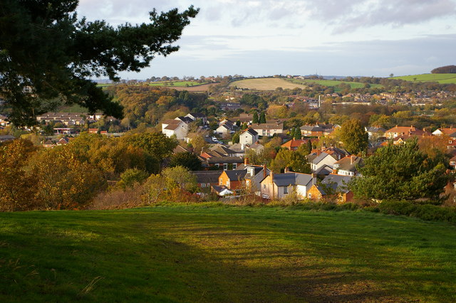
Square Coppice is a wood located in Worcestershire, England. It covers an area of approximately 20 acres and is situated in the heart of the county, near the village of Ombersley. The wood is part of a larger forested area known as the Worcestershire Forest.

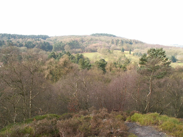
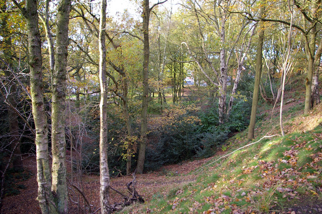
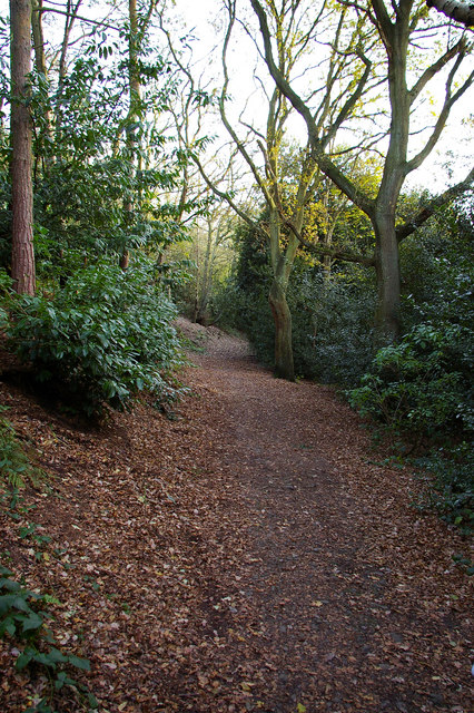
Square Coppice is predominantly composed of broadleaf trees, including oak, birch, and ash. These trees provide a dense canopy that creates a tranquil and shaded environment within the wood. Beneath the trees, the forest floor is carpeted with a variety of woodland plants, such as bluebells, primroses, and ferns, adding to the natural beauty of the area.

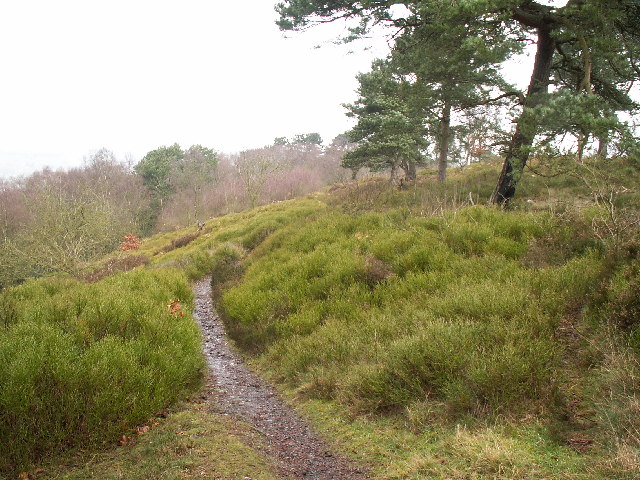
The wood is crisscrossed by a network of well-maintained footpaths, allowing visitors to explore its different areas and enjoy the peacefulness of the surroundings. These paths lead to various viewpoints, providing stunning vistas of the Worcestershire countryside.

Square Coppice is not only a haven for nature lovers but also a habitat for a diverse range of wildlife. The wood is home to numerous bird species, including woodpeckers, thrushes, and owls, which can often be spotted and heard while walking through the wood. Squirrels and rabbits are also commonly seen, and if lucky, visitors may even catch a glimpse of a deer or fox.

Overall, Square Coppice is a picturesque woodland that offers a welcome escape from the hustle and bustle of everyday life. Its natural beauty, diverse plant and animal life, and well-maintained footpaths make it a popular destination for both locals and tourists seeking to immerse themselves in the tranquility of nature.

If you have any feedback on the listing, please let us know in the comments section below.

Square Coppice Images

Images are sourced within 2km of 52.386715/-2.0263444 or Grid Reference SO9876. Thanks to Geograph Open Source API. All images are credited.

Traffic emerging from Edgewood Road Cars coming out onto the Lickey Road from Edgewood Road in Rednal.
Traffic emerging from Edgewood Road
Cars coming out onto the Lickey Road from Edgewood Road in Rednal.
The M5 skirts a hillock Seen from the lane that leads to Chadwich Grange.
The M5 skirts a hillock
Seen from the lane that leads to Chadwich Grange.
View from Bilberry Hill towards Beacon Hill Bilberry Hill is in the Lickey Hills Country Park. Together with its neighbours the hill is composed of Lickey Quartzite, one of the oldest rocks in the region. The Lickey Hills include some of the largest areas of bilberry and heather in the county. The hill in the distance is Beacon Hill. The open area in between is a golf course.
View from Bilberry Hill towards Beacon Hill
Bilberry Hill is in the Lickey Hills Country Park. Together with its neighbours the hill is composed of Lickey Quartzite, one of the oldest rocks in the region. The Lickey Hills include some of the largest areas of bilberry and heather in the county. The hill in the distance is Beacon Hill. The open area in between is a golf course.
Rednal Hill Rednal Hill was presented to the City of Birmingham in 1888 by the Birmingham Association for the Preservation of Open Spaces. Together with land donated by the Cadbury family it forms the Lickey Hills Country Park.
Rednal Hill
Rednal Hill was presented to the City of Birmingham in 1888 by the Birmingham Association for the Preservation of Open Spaces. Together with land donated by the Cadbury family it forms the Lickey Hills Country Park.
Toposcope, Beacon Hill The toposcope on Beacon Hill (298m) was constructed in 1923 after Beacon Hill was donated to the City of Birmingham by the Cadbury family. The toposcope was restored in 1988. From this viewpoint on a good day 13 old counties can be seen. Going east from the summit there is no higher land at the same latitude until you reach the Ural Mountains in Russia (I've checked this using Google Earth).
Toposcope, Beacon Hill
The toposcope on Beacon Hill (298m) was constructed in 1923 after Beacon Hill was donated to the City of Birmingham by the Cadbury family. The toposcope was restored in 1988. From this viewpoint on a good day 13 old counties can be seen. Going east from the summit there is no higher land at the same latitude until you reach the Ural Mountains in Russia (I've checked this using Google Earth).
Beacon Hill Looking south-west towards the car park from near the toposcope.
Beacon Hill
Looking south-west towards the car park from near the toposcope.
Road junction , Rubery The junction of School Road, Gannow Road and Gunner Lane in the south west corner of the square, looking north east. Waseley Hills High School and Holywell Junior School are just to the left of the picture.
Road junction , Rubery
The junction of School Road, Gannow Road and Gunner Lane in the south west corner of the square, looking north east. Waseley Hills High School and Holywell Junior School are just to the left of the picture.
Redhill Lane Looking south west towards Redhill Farm. The M5 motorway can be seen climbing up towards junction 4.
Redhill Lane
Looking south west towards Redhill Farm. The M5 motorway can be seen climbing up towards junction 4.
Birmingham Road, Lydiate Ash This road was formerly the A38 - however this section has been bypassed as the A38 now runs via junction 4 of the M5, several hundred metres west. Birmingham, Road is now little more than a quiet country lane, albeit a very wide, straight and well surfaced one.
Birmingham Road, Lydiate Ash
This road was formerly the A38 - however this section has been bypassed as the A38 now runs via junction 4 of the M5, several hundred metres west. Birmingham, Road is now little more than a quiet country lane, albeit a very wide, straight and well surfaced one.
Marlbrook Tip Photo taken from Marlbrook Lane. The owners of this former landfill site have plans to restore the area, and develop and nine hole golf course.
Marlbrook Tip
Photo taken from Marlbrook Lane. The owners of this former landfill site have plans to restore the area, and develop and nine hole golf course.
View south west from Windmill Hill, Waseley Hills Country Park Looking down a small valley from the footpath below the summit of the hill, late on a winter afternoon
View south west from Windmill Hill, Waseley Hills Country Park
Looking down a small valley from the footpath below the summit of the hill, late on a winter afternoon
Life in the slow lane Monday morning rush hour on the M5 just past junction 4 heading north
Life in the slow lane
Monday morning rush hour on the M5 just past junction 4 heading north
Rednal Hill, looking towards Rubery Looking out across leafy suburbia
Rednal Hill, looking towards Rubery
Looking out across leafy suburbia
Woodland on north west end of Rednal Hill
Bridleway below south western slope of Rednal Hill
Gateway to Parklands
Empire Cinema, Rubery
Premier Travel Inn, Park Way, Rubery
Show me another place!

Square Coppice is located at Grid Ref: SO9876 (Lat: 52.386715, Lng: -2.0263444)

Administrative County: Worcestershire

District: Bromsgrove

Police Authority: West Mercia

What 3 Words

///prefer.cost.mason. Near Barnt Green, Worcestershire

Related Wikis

Rubery

Rubery is the name of two adjacent settlements; one a village in the Bromsgrove District of Worcestershire, the other a suburb of Birmingham in the West...

Waseley Hills High School and Sixth Form Centre

Waseley Hills High School and Sixth Form Centre is a mixed secondary school and sixth form with academy status in the town of Rubery, on the border of...

St Chad's Church, Rubery

St Chad’s Church, Rubery is a Church of England parish church in Rubery, Worcestershire. == History == The church evolved in 1895 as a mission church from...

Rubery Hill Hospital

Rubery Hill Hospital was a mental health facility in Birmingham, England. The chapel, which still survives, is a Grade II listed building. == History... ==

Nearby Amenities

Located within 500m of 52.386715,-2.0263444
Source Maxspeed: survey
Lat/Long: 52.3897447/-2.0312251
Post Box
Operator: Royal Mail
Operator Wikidata: Q638098
Ref: B45 199
Source: survey
Lat/Long: 52.3901801/-2.0253679
Motorway Junction
Lat/Long: 52.3904248/-2.0283631
Post Box
Operator: Royal Mail
Operator Wikidata: Q638098
Ref: B45 368
Lat/Long: 52.3904833/-2.028945
Bus Stop
Whetty Lane / Birch Rd
Bus: yes
Naptan AtcoCode: 43000392002
Naptan Bearing: SW
Naptan BusStopType: MKD
Naptan CommonName: Birch Rd
Naptan Indicator: after
Naptan Landmark: Whetty Coppice
Naptan NaptanCode: nwmtpdgm
Naptan Status: ACT
Naptan StopType: BCT
Naptan Street: WHETTY LANE
Naptan Towards: Bromsgrove
Naptan Verified: no
Public Transport: platform
Route Ref: 144;202
Source: WMCA
Lat/Long: 52.390739/-2.0264206
Bus Stop
Old Plough Inn
Bus: yes
Naptan AtcoCode: 2000G323035
Naptan Bearing: NW
Naptan CommonName: Old Plough Inn
Naptan Indicator: Opp
Naptan Landmark: Old Plough Inn
Naptan NaptanCode: wocdwpdm
Naptan Street: Gannow Road
Naptan Verified: no
Public Transport: platform
Source: naptan_import
Lat/Long: 52.390911/-2.0286627
Grit Bin
Source: survey
Lat/Long: 52.3895232/-2.0318622
St Oswald's Camp
Source: survey
Lat/Long: 52.3889133/-2.0318769
Stock Hill
Natural: peak
Lat/Long: 52.3828556/-2.0236378
Fire Hydrant
Emergency: fire_hydrant
Fire Hydrant Type: underground
Source: survey
Lat/Long: 52.3898983/-2.0305771
Generator Method: photovoltaic
Generator Output Electricity: yes
Generator Source: solar
Generator Type: solar_photovoltaic_panel
Location: roof
Power: generator
Lat/Long: 52.3903091/-2.0292681
Generator Method: photovoltaic
Generator Output Electricity: yes
Generator Source: solar
Generator Type: solar_photovoltaic_panel
Location: roof
Power: generator
Lat/Long: 52.3908248/-2.0282221
Generator Method: photovoltaic
Generator Output Electricity: yes
Generator Source: solar
Generator Type: solar_photovoltaic_panel
Location: roof
Power: generator
Lat/Long: 52.3892607/-2.0223092
Motorway Junction
Lat/Long: 52.3908937/-2.0270818
Give Way
Direction: backward
Lat/Long: 52.390511/-2.0269899
Crossing
Crossing: unmarked
Crossing Island: no
Crossing Markings: no
Tactile Paving: yes
Lat/Long: 52.3907009/-2.0283279
Traffic Calming: table
Lat/Long: 52.3901834/-2.0307521
The data included in this document is from www.openstreetmap.org. The data is made available under ODbL.

Have you been to Square Coppice?

Leave your review of Square Coppice below (or comments, questions and feedback).