Comhampton

Settlement in Worcestershire Wychavon

England

Comhampton

Farmland north of Ombersley Flat meadows as far as the eye can see
Farmland north of Ombersley Credit: Eirian Evans

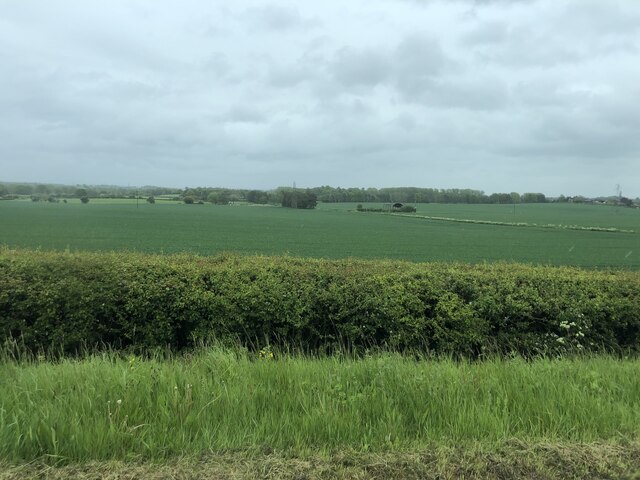
Comhampton is a picturesque village located in the county of Worcestershire, England. Situated in the heart of the countryside, it is surrounded by rolling hills and lush green fields, offering residents and visitors a serene and tranquil environment.

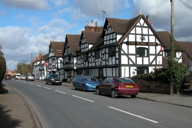
The village has a rich history, dating back centuries, and is known for its charming architecture. Many of the buildings in Comhampton are constructed from local stone, giving the village a distinctive and traditional feel. The village center features a beautiful church that serves as a focal point for the community.

Comhampton is a small village, with a population of approximately 500 residents. Despite its size, it boasts a strong sense of community and a range of amenities to cater to the needs of its inhabitants. These include a local pub, a village hall, and a small convenience store, which provides essential goods to the locals.

The village is well-connected to the surrounding areas, with good transport links. The nearby town of Worcester is just a short drive away, offering a wider range of amenities and services. Comhampton is also within easy reach of the M5 motorway, providing easy access to other parts of the country.

For those who enjoy outdoor activities, Comhampton is an ideal location. The countryside surrounding the village offers numerous walking and cycling routes, allowing residents to explore the natural beauty of the area.

In summary, Comhampton is a charming and idyllic village in Worcestershire, offering a peaceful retreat for its residents and visitors alike. With its rich history, beautiful architecture, and stunning countryside, it is a place that captures the essence of rural England.

If you have any feedback on the listing, please let us know in the comments section below.

Comhampton Images

Images are sourced within 2km of 52.283769/-2.237448 or Grid Reference SO8365. Thanks to Geograph Open Source API. All images are credited.

Farmland north of Ombersley Flat meadows as far as the eye can see
Farmland north of Ombersley
Flat meadows as far as the eye can see
Fields next to a footpath, near to Uphampton
Field boundary near Uphampton, Worcestershire
Walkers heading for Boreley House With the Abberley Hills in the distance.
Walkers heading for Boreley House
With the Abberley Hills in the distance.
Farm buildings at Boreley House with Woodbury Hill behind
Black Barn, Boreley Lane from the field side
A very distant view of Abberley Clocktower
Brook Cottages, Boreley Lane, Ombersley
Houses at Holt Fleet from the riverside path (1)
Houses at Holt Fleet from the riverside path (2)
Looking across Ombersley Park With Ombersley Court and St Andrew Church.
Looking across Ombersley Park
With Ombersley Court and St Andrew Church.
Ombersley Court from the footpath by the fishponds
St Andrews Church, Ombersley from the South West
Tolley Memorial in the churchyard, Ombersley Early 19th century chest tomb commemorating Henry Godfrey Tolley, died 1822. Listed Grade II.
Tolley Memorial in the churchyard, Ombersley
Early 19th century chest tomb commemorating Henry Godfrey Tolley, died 1822. Listed Grade II.
Churchyard wall and gates, Ombersley These are c1830 and Listed Grade II.
Churchyard wall and gates, Ombersley
These are c1830 and Listed Grade II.
Pardoe Memorial, St Andrew's churchyard, Ombersley A disintegrating early 19th century chest tomb for Richard Pardoe, died 1807. Listed Grade II.
Pardoe Memorial, St Andrew's churchyard, Ombersley
A disintegrating early 19th century chest tomb for Richard Pardoe, died 1807. Listed Grade II.
Pedestal tomb in St Andrew's churchyard, Ombersley Early 19th century in sandstone ashlar and Listed Grade II. The inscriptions are illegible.
Pedestal tomb in St Andrew's churchyard, Ombersley
Early 19th century in sandstone ashlar and Listed Grade II. The inscriptions are illegible.
Watkins Memorial, St Andrew's Churchyard, Ombersley Early 19th century in sandstone ashlar with panels commemorating Mary Watkins, died 1816, and John Watkins, died 1833. Listed Grade II. The Sandys Mausoleum is in the left background.
Watkins Memorial, St Andrew's Churchyard, Ombersley
Early 19th century in sandstone ashlar with panels commemorating Mary Watkins, died 1816, and John Watkins, died 1833. Listed Grade II. The Sandys Mausoleum is in the left background.
Show me another place!

Comhampton is located at Grid Ref: SO8365 (Lat: 52.283769, Lng: -2.237448)

Administrative County: Worcestershire

District: Wychavon

Police Authority: West Mercia

What 3 Words

///multiples.overtones.respect. Near Hartlebury, Worcestershire

Related Wikis

Ombersley and Doverdale

Ombersley and Doverdale is an area in Wychavon district, Worcestershire, England served by a single parish council but comprising the two separate civil...

Ombersley

Ombersley is a village and civil parish in Wychavon district, in the county of Worcestershire, England. The parish includes the hamlet of Holt Fleet,...

Dunhampton

Dunhampton is a village in Worcestershire, England.

Holt Fleet Bridge

Holt Fleet Bridge, also known as Holt Bridge, is a cast-iron arch bridge over the River Severn, at Holt in Worcestershire, England. It has a span of 150...

Doverdale

Doverdale is a small village and civil parish in Worcestershire, England, to the west of Droitwich. It has a parish church. Doverdale Manor is one of largest...

Holt, Worcestershire

Holt is a village and civil parish in the Malvern Hills District of the county of Worcestershire, England. The church is dedicated to St. Martin, and dates...

Dick Brook

Dick Brook is small tributary stream of the River Severn that flows through Worcestershire, England.The brook is formed from two small unnamed streams...

Holt Heath, Worcestershire

Holt Heath, in the parish of Holt, is a village near the west bank of the River Severn in Worcestershire. The nearest towns are all about 6 miles away...

Nearby Amenities

Located within 500m of 52.283769,-2.237448
Bus Stop
Reindeer Inn
Bus: yes
Naptan AtcoCode: 2000G502415
Naptan Bearing: N
Naptan CommonName: Reindeer Inn
Naptan Indicator: adj
Naptan NaptanCode: wocdpwaj
Naptan Street: A449 North Bound
Naptan Verified: no
Public Transport: platform
Source: naptan_import
Lat/Long: 52.2831275/-2.2302001
Bus Stop
Northampton Turn
Bus: yes
Naptan AtcoCode: 2000G502442
Naptan Bearing: S
Naptan CommonName: Northampton Turn
Naptan Indicator: opp
Naptan NaptanCode: wocgmgwm
Naptan Street: A449
Naptan Verified: no
Public Transport: platform
Source: naptan_import
Lat/Long: 52.2852684/-2.2305414
Power: pole
Lat/Long: 52.2872578/-2.2415502
Power: pole
Lat/Long: 52.2867377/-2.2410192
Woodfield
Power: pole
Transformer: distribution
Voltage Primary: 11000
Lat/Long: 52.286156/-2.240417
Power: pole
Lat/Long: 52.2861815/-2.2399409
Power: pole
Lat/Long: 52.2864571/-2.2388345
Power: pole
Lat/Long: 52.2864079/-2.2377053
Power: pole
Lat/Long: 52.2866417/-2.2369033
Power: pole
Lat/Long: 52.286864/-2.2360986
Power: pole
Lat/Long: 52.2868878/-2.2353396
Power: pole
Lat/Long: 52.2866261/-2.2344773
Power: pole
Lat/Long: 52.2870888/-2.2332837
Power: pole
Lat/Long: 52.2863734/-2.2336042
Power: pole
Lat/Long: 52.2860715/-2.2325581
Oldfield North
Power: pole
Transformer: distribution
Voltage Primary: 11000
Lat/Long: 52.2855334/-2.2319573
Power: pole
Lat/Long: 52.2862725/-2.2320203
Oldfield West
Power: pole
Transformer: distribution
Voltage Primary: 11000
Lat/Long: 52.2824937/-2.2322604
Power: pole
Lat/Long: 52.2826041/-2.2312599
Fruiterers Arms
Power: pole
Transformer: distribution
Voltage Primary: 11000
Lat/Long: 52.2810005/-2.236336
Power: pole
Lat/Long: 52.2797451/-2.2361523
Power: pole
Lat/Long: 52.2800577/-2.2359726
Uphampton North
Power: pole
Transformer: distribution
Voltage Primary: 11000
Lat/Long: 52.2799166/-2.2409709
Power: pole
Lat/Long: 52.2797066/-2.2401837
Power: pole
Lat/Long: 52.2795695/-2.2396807
Power: pole
Lat/Long: 52.2797533/-2.2376101
Power: pole
Lat/Long: 52.2794465/-2.236324
The data included in this document is from www.openstreetmap.org. The data is made available under ODbL.

Have you been to Comhampton?

Leave your review of Comhampton below (or comments, questions and feedback).