Combe Common

Settlement in Surrey Waverley

England

Combe Common

Toll House, Chiddingfold What looks to be an ex-toll house. The brick fabric looks late for a toll house so may well have served the Petworth Turnpike Trust in its dying years. It would have replaced a Toll House SSE on the North side of the ford/bridge at Northbridge.

Milestone Society National ID: SY.CHI
Toll House, Chiddingfold Credit: Lionel Joseph

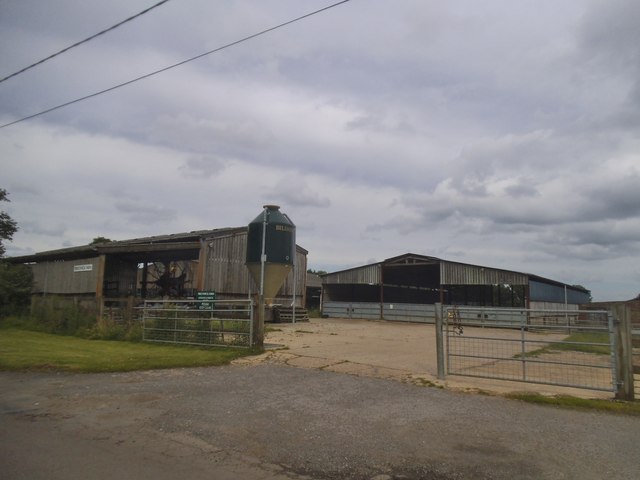
Combe Common is a picturesque area located in Surrey, England. This charming countryside spot is nestled within the Surrey Hills Area of Outstanding Natural Beauty, offering visitors and residents alike a tranquil escape from the hustle and bustle of everyday life.

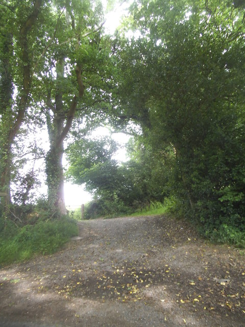
Covering a vast area of open grassland, Combe Common is known for its rolling hills, lush meadows, and diverse wildlife. The landscape is dotted with ancient woodlands, creating a striking contrast against the open spaces. This variety of habitats makes it a haven for a wide range of plant and animal species, including rare butterflies, birds, and wildflowers.

Combe Common is also home to a network of walking trails and footpaths, providing ample opportunities for outdoor exploration. Hikers and nature enthusiasts can enjoy breathtaking views of the surrounding countryside as they meander through the area. The common is particularly popular among dog walkers, who appreciate the vast space and peaceful atmosphere.

In addition to its natural beauty, Combe Common holds historical significance. The area has been inhabited for centuries, with evidence of prehistoric settlements and Roman activity. Archaeological finds, such as coins and pottery, have been unearthed in the vicinity, adding to the area's allure.

Overall, Combe Common offers a tranquil and idyllic setting for those seeking a connection with nature. Its stunning landscapes, diverse wildlife, and historical significance make it a must-visit destination for both locals and tourists alike.

If you have any feedback on the listing, please let us know in the comments section below.

Combe Common Images

Images are sourced within 2km of 51.114185/-0.643186 or Grid Reference SU9535. Thanks to Geograph Open Source API. All images are credited.

Toll House, Chiddingfold What looks to be an ex-toll house. The brick fabric looks late for a toll house so may well have served the Petworth Turnpike Trust in its dying years. It would have replaced a Toll House SSE on the North side of the ford/bridge at Northbridge.

Milestone Society National ID: SY.CHI
Toll House, Chiddingfold
What looks to be an ex-toll house. The brick fabric looks late for a toll house so may well have served the Petworth Turnpike Trust in its dying years. It would have replaced a Toll House SSE on the North side of the ford/bridge at Northbridge. Milestone Society National ID: SY.CHI
Prestwick Lane at the junction of Combe Lane
Combe Lane, Combe Common
Ridgley Road at the junction of Coxcomb Lane
Prestwick Lane, Combe Common
Cottage on Combe Lane, Chiddingfold
Shops on The Green, Chiddingfold
Shops on The Green, Chiddingfold A very small Boots, one of the few large chains who kept their village shops as well.
Shops on The Green, Chiddingfold
A very small Boots, one of the few large chains who kept their village shops as well.
House on The Green, Chiddingfold
Phillips of Wormley
Phillips of Wormley
The Winterton Arms, Chiddingfold
Houses on Petworth Road, Chiddingfold
Petworth Road, Chiddingfold
Old house on Petworth Road, Chiddingfold
Prestwick Farm, Grayswood
Path to Langhurst Manor
Show me another place!

Combe Common is located at Grid Ref: SU9535 (Lat: 51.114185, Lng: -0.643186)

Administrative County: Surrey

District: Waverley

Police Authority: Surrey

What 3 Words

///example.taxed.lengthen. Near Chiddingfold, Surrey

Related Wikis

St Teresa of Avila Church, Chiddingfold

St Teresa of Avila Church is a Roman Catholic Parish church in Chiddingfold, Surrey. It is situated on the corner of Petworth Road and Woodside Road in...

Chiddingfold

Chiddingfold is a village and civil parish in the Weald in the Waverley district of Surrey, England. It lies on the A283 road between Milford and Petworth...

Netherside Stream Outcrops

Netherside Stream Outcrops is a 2.9-hectare (7.2-acre) geological Site of Special Scientific Interest north-east of Haslemere in Surrey. It is a Geological...

Witley railway station

Witley railway station is a station on the Portsmouth Direct Line in Surrey, England. It is 38 miles 36 chains (61.9 km) down the line from London Waterloo...

Tigbourne Court

Tigbourne Court is an Arts and Crafts style country house in Wormley, Surrey, England, 1 mile (1.6 km) south of Witley. It was designed by architect Edwin...

Pickhurst

Pickhurst is a grade II* listed house set in 130 acres (53 ha) of land near Chiddingfold, Surrey, England. == History == It was designed by the Scottish...

Ramsnest Common

Ramsnest Common is a hamlet in the far south of the Borough of Waverley, the largest district of Surrey, England centred on the A283 1.5 miles (2.4 km...

Wormley, Surrey

Wormley is a village in Surrey, England in the parish of Witley, around Witley station, off the A283 Petworth Road about 5 km (3.1 mi) SSW of Godalming...

Nearby Amenities

Located within 500m of 51.114185,-0.643186
Bus Stop
Woodside Road
Naptan AtcoCode: 40004411438A
Naptan Bearing: N
Naptan CommonName: Woodside Road
Naptan Indicator: N-bound
Naptan Landmark: Woodside Road
Naptan NaptanCode: surgjmpg
Naptan Street: Woodside Road
Naptan Verified: no
Source: naptan_import
Lat/Long: 51.1163561/-0.6487013
Bus Stop
Woodside Road
Naptan AtcoCode: 40004411439A
Naptan Bearing: S
Naptan CommonName: Woodside Road
Naptan Indicator: S-bound
Naptan Landmark: Woodside Road
Naptan NaptanCode: surgjmpj
Naptan Street: Woodside Road
Naptan Verified: no
Source: naptan_import
Lat/Long: 51.1164978/-0.6485115
Bus Stop
Ridgeley Garage
Bus: yes
Naptan AtcoCode: 40004411992A
Naptan Bearing: W
Naptan CommonName: Ridgeley Garage
Naptan Indicator: W-bound
Naptan Landmark: Ridgeley Garage
Naptan NaptanCode: surgmtpd
Naptan Street: Woodside Road
Naptan Verified: no
Public Transport: platform
Source: naptan_import
Lat/Long: 51.1140869/-0.6430098
Bus Stop
Ridgeley Garage
Bus: yes
Naptan AtcoCode: 40004411996A
Naptan Bearing: E
Naptan CommonName: Ridgeley Garage
Naptan Indicator: E-bound
Naptan Landmark: Ridgeley Garage
Naptan NaptanCode: surgmtpt
Naptan Street: Woodside Road
Naptan Verified: no
Public Transport: platform
Source: naptan_import
Lat/Long: 51.1139318/-0.6428144
Great Oaks Farm
Landuse: farm
Note Retag: CS #48756035
Source: os_street_view
Lat/Long: 51.112865/-0.6431708
Natural: spring
Source: os_street_view
Lat/Long: 51.1185538/-0.6425525
Barrier: stile
Lat/Long: 51.1103493/-0.6397653
Barrier: stile
Lat/Long: 51.1104921/-0.6419208
Barrier: stile
Lat/Long: 51.1105954/-0.6419686
Barrier: stile
Lat/Long: 51.1115662/-0.6458223
Barrier: stile
Lat/Long: 51.1126311/-0.6422506
Barrier: stile
Lat/Long: 51.113856/-0.6421536
Post Box
Collection Plate: CP1
Collection Times: Mo-Fr 16:00; Sa 09:30
Last Checked: 2020-09-17
Operator: Royal Mail
Post Box Type: pillar
Ref: GU8 114
Royal Cypher: EIIR
Royal Cypher Wikidata: Q33102113
Source: survey
Lat/Long: 51.1135553/-0.6406488
Post Box
Collection Plate: CP7D
Collection Times: Mo-Fr 09:00; Sa 07:00
Last Checked: 2020-09-17
Old Ref: GU8 32
Operator: Royal Mail
Post Box Type: lamp
Ref: GU8 32D
Royal Cypher: EIIR
Royal Cypher Wikidata: Q33102113
Source: survey
Lat/Long: 51.1166797/-0.6484663
Grit Bin
Description: For highways use only.
Operator: Surrey County Council
Ref: 11930
Source: survey
Lat/Long: 51.1140387/-0.6424159
Grit Bin
Colour: yellow
Description: This grit bin is for highways use only.
Operator: Surrey County Council
Ref: 11815
Source: survey
Lat/Long: 51.1135887/-0.6406225
Waste Basket
Colour: green
Covered: no
Source: survey
Lat/Long: 51.1138918/-0.6420816
Waste Basket
Colour: green
Covered: no
Source: survey
Lat/Long: 51.1136185/-0.6406025
The data included in this document is from www.openstreetmap.org. The data is made available under ODbL.

Have you been to Combe Common?

Leave your review of Combe Common below (or comments, questions and feedback).