Steart Wood

Wood, Forest in Somerset Somerset West and Taunton

England

Steart Wood

Exebridge at Exebridge Seen from the beer garden of The Anchor Inn. The three arch stone bridge is thought to be 18th century (but with a bridge in this location since the 14th century) with major repairs in 1853 and 1929. The river is the boundary between Devon (right) and Somerset (left).
Exebridge at Exebridge Credit: Chris Allen

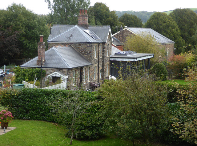
Steart Wood is a charming forest located in the county of Somerset, England. Spanning over an area of approximately 550 acres, this woodland is a haven for nature lovers and outdoor enthusiasts alike. The forest is situated at the mouth of the River Parrett, near the village of Steart, and is managed by the Forestry Commission.

Steart Wood boasts a diverse range of tree species, including oak, beech, and birch, creating a rich and varied landscape. The forest is also home to an array of wildlife, making it an ideal location for nature spotting and birdwatching. Visitors may be lucky enough to catch a glimpse of deer, foxes, badgers, and various species of birds that call this woodland their home.

The wood offers a network of well-maintained trails, providing ample opportunities for leisurely walks, trail running, and cycling. The paths wind through the forest, offering stunning views of the surrounding countryside and the nearby estuary. Additionally, the forest is intersected by a number of small streams, further enhancing its natural beauty.

Steart Wood is a popular destination for families and nature enthusiasts throughout the year. In the spring, the forest comes alive with vibrant wildflowers and blossoming trees, creating a picturesque setting. During autumn, the woodland is transformed into a kaleidoscope of colors as the leaves change, offering a breathtaking sight.

Overall, Steart Wood is a captivating woodland that offers a peaceful escape from the hustle and bustle of everyday life. With its stunning natural beauty and diverse wildlife, it is a must-visit destination for those seeking to reconnect with nature.

If you have any feedback on the listing, please let us know in the comments section below.

Steart Wood Images

Images are sourced within 2km of 51.025102/-3.5308756 or Grid Reference SS9226. Thanks to Geograph Open Source API. All images are credited.

Exebridge at Exebridge Seen from the beer garden of The Anchor Inn. The three arch stone bridge is thought to be 18th century (but with a bridge in this location since the 14th century) with major repairs in 1853 and 1929. The river is the boundary between Devon (right) and Somerset (left).
Exebridge at Exebridge
Seen from the beer garden of The Anchor Inn. The three arch stone bridge is thought to be 18th century (but with a bridge in this location since the 14th century) with major repairs in 1853 and 1929. The river is the boundary between Devon (right) and Somerset (left).
The Anchor Inn, Exebridge By the River Exe and the eponymous bridge. The three arch masonry bridge is on the right. This was a quick stop on the way to Dulverton. I believe the pub is just in Devon as the river is the boundary with Somerset.
The Anchor Inn, Exebridge
By the River Exe and the eponymous bridge. The three arch masonry bridge is on the right. This was a quick stop on the way to Dulverton. I believe the pub is just in Devon as the river is the boundary with Somerset.
Former Dulverton Station Seen from a bridge over the dismantled railway line. The stationmaster's house and goods shed were built by the Devon and somerset Railway and opened in 1873. The Exe Valley Railway also had its terminus here. The station is actually about 2 miles south of Dulverton and in Brushford.
Former Dulverton Station
Seen from a bridge over the dismantled railway line. The stationmaster's house and goods shed were built by the Devon and somerset Railway and opened in 1873. The Exe Valley Railway also had its terminus here. The station is actually about 2 miles south of Dulverton and in Brushford.
Brushford : Exebridge - River Exe Looking across the River Exe which has flooded.
Brushford : Exebridge - River Exe
Looking across the River Exe which has flooded.
Brushford : Exebridge - River Exe Looking down the River Exe from Exe Bridge.
Brushford : Exebridge - River Exe
Looking down the River Exe from Exe Bridge.
Morebath - Exebridge - The Anchor Inn The Anchor Inn has flooded.
Morebath - Exebridge - The Anchor Inn
The Anchor Inn has flooded.
Morebath - Exebridge - River Exe Looking across the flooded River Exe.
Morebath - Exebridge - River Exe
Looking across the flooded River Exe.
Morebath : Exebridge - B3222 The road heads through Exebridge, passing the Anchor Inn.
Morebath : Exebridge - B3222
The road heads through Exebridge, passing the Anchor Inn.
Morebath : Exebridge - B3222 Looking along the flooded B3222 road.
Morebath : Exebridge - B3222
Looking along the flooded B3222 road.
Morebath - Exebridge - The Anchor Inn The Anchor Inn in Exebridge.
Morebath - Exebridge - The Anchor Inn
The Anchor Inn in Exebridge.
Morebath : Exebridge - B3222 It is impossible to pass through this stretch of road.
Morebath : Exebridge - B3222
It is impossible to pass through this stretch of road.
Morebath : Exebridge - B3222 Two cars are submerged in the water as the River Exe bursts its banks.
Morebath : Exebridge - B3222
Two cars are submerged in the water as the River Exe bursts its banks.
Morebath - Exebridge - The Anchor Inn The Anchor Inn with the River Exe floods taking its toll.
Morebath - Exebridge - The Anchor Inn
The Anchor Inn with the River Exe floods taking its toll.
Brushford : Exebridge - River Exe Looking across Exe Bridge and towards the car park which is situated by the bridge, and is today underwater.
Brushford : Exebridge - River Exe
Looking across Exe Bridge and towards the car park which is situated by the bridge, and is today underwater.
Morebath : Exebridge - B3222 Looking along the road which is under the water.
Morebath : Exebridge - B3222
Looking along the road which is under the water.
Morebath : Exebridge - B3222 Two people walk through the floodwaters of the River Exe.
Morebath : Exebridge - B3222
Two people walk through the floodwaters of the River Exe.
Morebath : Exebridge - B3222 The road is flooded.
Morebath : Exebridge - B3222
The road is flooded.
Morebath : Exebridge - B3222 The road has been closed due to the flooding.
Morebath : Exebridge - B3222
The road has been closed due to the flooding.
Show me another place!

Steart Wood is located at Grid Ref: SS9226 (Lat: 51.025102, Lng: -3.5308756)

Administrative County: Somerset

District: Somerset West and Taunton

Police Authority: Avon and Somerset

What 3 Words

///ship.seasonal.concerned. Near Dulverton, Somerset

Related Wikis

Brushford, Somerset

Brushford is a village and civil parish 2 miles (3.2 km) south of Dulverton and 12 miles (19 km) north of Tiverton in Devon, in the Somerset West and Taunton...

River Haddeo

The River Haddeo on Exmoor in Somerset, England flows from the Wimbleball Lake to the River Exe. The valley of the river consists of three tributary valleys...

Bury Castle, Brompton Regis

Bury Castle near Brompton Regis in the English county of Somerset was an Iron Age univallate hillfort which was reused with the creation of a motte after...

Combe, Dulverton

Combe is a historic estate in Somerset, England, situated between the town of Dulverton and the village of Brushford. == Descent == === Taunton Priory... ===

River Barle

The River Barle runs from the Chains on northern Exmoor, in Somerset, England to join the River Exe at Exebridge, Devon. The river and the Barle Valley...

Exebridge

Exebridge is a village that lies on the border between Devon and Somerset, England. It lies at the confluence of the Barle and Exe rivers. Exebridge is...

Bury Bridge

Bury Bridge at Bury in the parish of Brompton Regis within the English county of Somerset is a medieval packhorse bridge. It has been scheduled as an ancient...

Dulverton Town Hall

Dulverton Town Hall is a municipal building in Fore Street in Dulverton, Somerset, England. The building, which is the meeting place of Dulverton Town...

Nearby Amenities

Located within 500m of 51.025102,-3.5308756
Direction: forward
Maxspeed: 30 mph
Maxspeed Type: GB:nsl_restricted
Source Maxspeed: sign
Traffic Sign: maxspeed
Lat/Long: 51.0236771/-3.5341787
Give Way
Direction: backward
Lat/Long: 51.0213445/-3.5331441
Give Way
Direction: backward
Lat/Long: 51.0209933/-3.5332149
Generator Method: photovoltaic
Generator Output Electricity: yes
Generator Source: solar
Generator Type: solar_photovoltaic_panel
Location: roof
Power: generator
Lat/Long: 51.0228685/-3.5346968
Generator Method: photovoltaic
Generator Output Electricity: yes
Generator Source: solar
Generator Type: solar_photovoltaic_panel
Location: roof
Power: generator
Lat/Long: 51.0228517/-3.5348014
Power: pole
Source: bing
Lat/Long: 51.0277324/-3.5356101
Power: pole
Source: bing
Lat/Long: 51.0271403/-3.5350415
Power: pole
Source: bing
Lat/Long: 51.0265439/-3.5344635
Power: pole
Source: bing
Lat/Long: 51.0259585/-3.5338976
Power: pole
Source: bing
Lat/Long: 51.0253605/-3.5333182
Power: pole
Source: bing
Lat/Long: 51.0247793/-3.5327563
Power: pole
Source: bing
Lat/Long: 51.0221744/-3.5314044
Poles: bipole
Power: pole
Source: bing
Transformer: distribution
Lat/Long: 51.0217576/-3.5328233
Power: pole
Source: bing
Lat/Long: 51.0224004/-3.5304683
Power: pole
Source: bing
Lat/Long: 51.0217197/-3.5298514
Power: pole
Source: bing
Lat/Long: 51.0210077/-3.5292184
Pixton Hill
Access: private
Ele: 239
Natural: peak
Lat/Long: 51.027388/-3.5271479
The data included in this document is from www.openstreetmap.org. The data is made available under ODbL.

Have you been to Steart Wood?

Leave your review of Steart Wood below (or comments, questions and feedback).