Bigton

Settlement in Shetland

Scotland

Bigton

The slopes of Ward of Scousburgh From the minor road which serves various transmission masts and a former NATO station. Below is St Ninian's Isle and the tombolo which connects it to Shetland Mainland.
The slopes of Ward of Scousburgh Credit: Michael Earnshaw

Bigton is a small village located on the southern coast of the Shetland Islands, Scotland. Situated approximately 20 miles southwest of Lerwick, the main town in Shetland, Bigton is known for its picturesque landscapes and unique heritage.

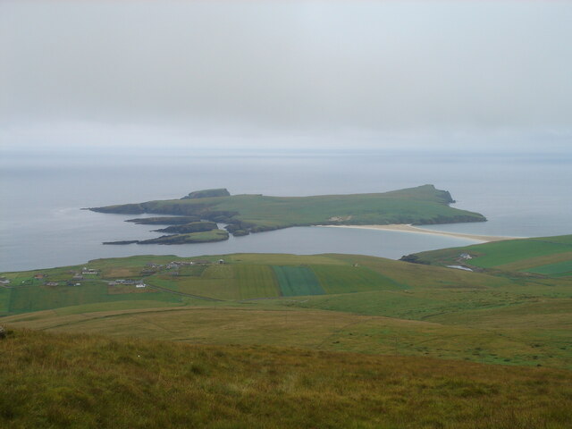
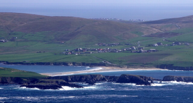
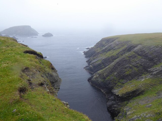
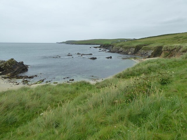
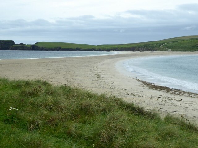
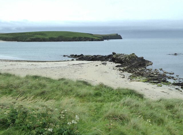
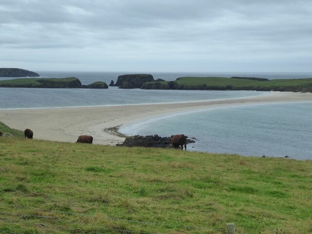
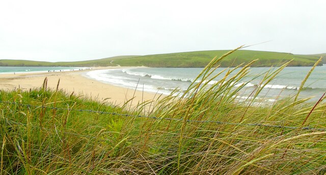
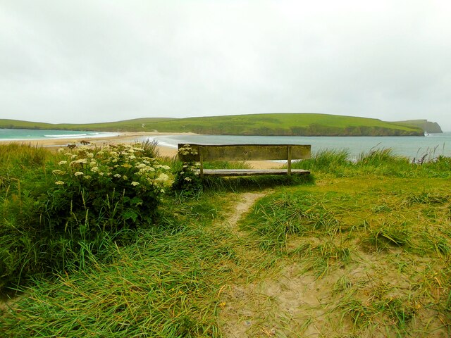
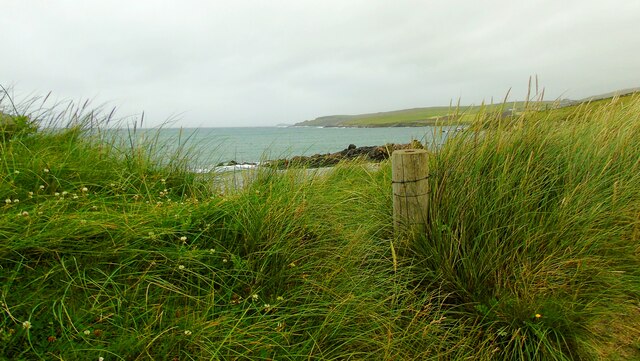
Nestled between the rugged cliffs and the North Atlantic Ocean, Bigton offers breathtaking views of the surrounding countryside. The village is surrounded by rolling hills, lush green fields, and beautiful sandy beaches, making it a popular destination for nature lovers and outdoor enthusiasts.

With a population of around 200 people, Bigton maintains a close-knit community feel. The village is home to a range of amenities, including a primary school, a church, and a local community hall. The primary industry in the area is fishing, with many residents working in the nearby fishing industry.

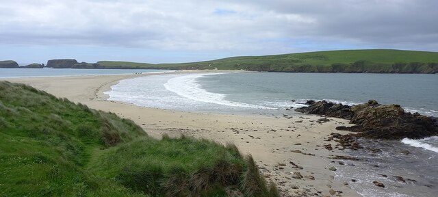
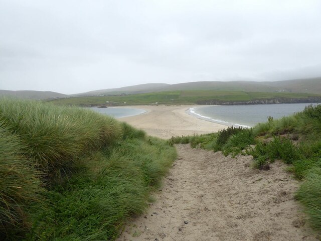
The area surrounding Bigton is rich in historical and archaeological sites. One notable attraction is St. Ninian's Isle, a small tidal island that can be reached by a sandy tombolo. Here, visitors can explore the ruins of a 12th-century chapel and witness the discovery of the famous St. Ninian's Isle treasure, a collection of Pictish silver artifacts.

For those seeking outdoor activities, Bigton offers various opportunities for hiking, birdwatching, and beachcombing. The nearby beaches, such as Spiggie Beach and West Voe, are ideal for leisurely walks and picnics.

Overall, Bigton is a tranquil and picturesque village that offers a glimpse into the natural beauty and rich history of the Shetland Islands.

If you have any feedback on the listing, please let us know in the comments section below.

Bigton Images

Images are sourced within 2km of 59.975024/-1.322205 or Grid Reference HU3721. Thanks to Geograph Open Source API. All images are credited.

The slopes of Ward of Scousburgh From the minor road which serves various transmission masts and a former NATO station. Below is St Ninian's Isle and the tombolo which connects it to Shetland Mainland.
The slopes of Ward of Scousburgh
From the minor road which serves various transmission masts and a former NATO station. Below is St Ninian's Isle and the tombolo which connects it to Shetland Mainland.
Loose Head, St Ninian's Isle, from the air
St Ninian's Ayre from the air
St Ninian's Ayre
St Ninian's Ayre
St Ninian's Ayre
St Ninian's Ayre
Track on St Ninian's Isle Leading down to the tombolo which ties the island to the mainland.
Track on St Ninian's Isle
Leading down to the tombolo which ties the island to the mainland.
Ruins of St Ninian's Chapel In the middle distance, the tombolo which ties St Ninian's Isle to the mainland.
Ruins of St Ninian's Chapel
In the middle distance, the tombolo which ties St Ninian's Isle to the mainland.
Inlet on the west coast of St Ninian's Isle Out to sea is the island of Hich Holm <a href="https://www.geograph.org.uk/gridref/HU3521">HU3521</a> and to the right, Fora Stack.
Inlet on the west coast of St Ninian's Isle
Out to sea is the island of Hich Holm HU3521 and to the right, Fora Stack.
Rocky shore at Bigton
Tombolo linking Mainland to St Ninian's Isle A textbook example of a tombolo. Bigton Wick to the right, St Ninian's Bay to the left.
Tombolo linking Mainland to St Ninian's Isle
A textbook example of a tombolo. Bigton Wick to the right, St Ninian's Bay to the left.
Bigton Wick Looking across the bay to St Ninian's Isle.
Bigton Wick
Looking across the bay to St Ninian's Isle.
View from Bigton Looking over the tombolo towards St Ninian's Bay and the southern end of St Ninian's Isle.
View from Bigton
Looking over the tombolo towards St Ninian's Bay and the southern end of St Ninian's Isle.
View north from Bigton Ireland Wick and the hamlet of Ireland on the far hillside.
View north from Bigton
Ireland Wick and the hamlet of Ireland on the far hillside.
Tombolo at St Ninian's Isle Taken on St Ninian's beach at Bigton, Shetland, I am looking along the tombolo linking the mainland to St Ninian's Isle, site of the remains of St Ninian's Chapel.
Tombolo at St Ninian's Isle
Taken on St Ninian's beach at Bigton, Shetland, I am looking along the tombolo linking the mainland to St Ninian's Isle, site of the remains of St Ninian's Chapel.
St Ninian's Bay I am standing at the mainland end of the tombolo leading to St Ninian's Isle and looking south down St Ninian's Bay towards Inns Holm with Colsay off to the right. Northern Ness, Fora Ness and Noss Hill can be gilmpsed in the clouded distance.
St Ninian's Bay
I am standing at the mainland end of the tombolo leading to St Ninian's Isle and looking south down St Ninian's Bay towards Inns Holm with Colsay off to the right. Northern Ness, Fora Ness and Noss Hill can be gilmpsed in the clouded distance.
St Ninian's Isle I am just above the beach at Bigton Wick and looking across to the north end of St Ninian's Isle where the ruins of St Ninian's Chapel are to be found. The cliffs of Scarfi Taing are discernible to the right.
St Ninian's Isle
I am just above the beach at Bigton Wick and looking across to the north end of St Ninian's Isle where the ruins of St Ninian's Chapel are to be found. The cliffs of Scarfi Taing are discernible to the right.
Ireland Wick to Griskerry I am on St Ninian's beach, Bigton, Shetland, and looking north west along the coast past the Wick of Ireland (and the settlement of Ireland behind it) towards Griskerry, the summit of which can be glimpsed on the horizon (centre of shot).
Ireland Wick to Griskerry
I am on St Ninian's beach, Bigton, Shetland, and looking north west along the coast past the Wick of Ireland (and the settlement of Ireland behind it) towards Griskerry, the summit of which can be glimpsed on the horizon (centre of shot).
The south of St Ninian's Isle Seen from high on the slopes of Ward of Scousburgh, St Ninian's Isle seems to be preparing to repel boarders from the south (left).

The small village in the foreground is Rerwick.
The south of St Ninian's Isle
Seen from high on the slopes of Ward of Scousburgh, St Ninian's Isle seems to be preparing to repel boarders from the south (left). The small village in the foreground is Rerwick.
Show me another place!

Bigton is located at Grid Ref: HU3721 (Lat: 59.975024, Lng: -1.322205)

Unitary Authority: Shetland Islands

Police Authority: Highlands and Islands

What 3 Words

///newspaper.dizzy.hence. Near Sandwick, Shetland Islands

Related Wikis

Bigton

Bigton is a small settlement on South Mainland, Shetland, UK. Bigton is within the civil parish of Dunrossness.Bigton lies on the Atlantic coast of the...

St Ninian's Isle

St Ninian's Isle is a small tied island connected by the largest tombolo in the UK to the south-western coast of the Mainland, Shetland, in Scotland. It...

Levenwick

Levenwick is a small village about 17 miles (27 km) south of Lerwick, on the east side of the South Mainland of Shetland, Scotland. It is part of the parish...

Colsay

Colsay is an uninhabited island off the South West coast of Mainland, Shetland. Fora Ness lies to the south, across the Muckle Sound. The highest elevation...

Scousburgh

Scousburgh is a small community in the parish of Dunrossness, in the South Mainland of Shetland, Scotland, overlooking the picturesque Scousburgh Sand...

Clumlie Broch

Clumlie Broch is an Iron Age broch located on Mainland, Shetland, in Scotland (grid reference HU40451811). == Location == Clumlie Broch is located in Dunrossness...

Dunrossness

Dunrossness, (Old Norse: Dynrastarnes meaning "headland of the loud tide-race", referring to the noise of Sumburgh Roost) is the southernmost parish of...

Hoswick

Hoswick is a settlement in Sandwick in the south mainland of Shetland, Scotland, on the eastern part of the Dunrossness civil parish. It is separated from...

Nearby Amenities

Located within 500m of 59.975024,-1.322205
Bigton
Place: village
Lat/Long: 59.9732356/-1.3231855
Post Box
Brand: Royal Mail
Brand Wikidata: Q638098
Operator: Royal Mail
Operator Wikidata: Q638098
Post Box Type: lamp
Ref: ZE2 22
Royal Cypher: scottish_crown
Lat/Long: 59.9730517/-1.3239215
Barrier: cattle_grid
Lat/Long: 59.9730488/-1.3279024
Barrier: cattle_grid
Lat/Long: 59.972928/-1.327999
Recycling
Lat/Long: 59.9730477/-1.3235856
Bigton Community Shop
Addr City: Shetland
Addr Postcode: ZE2 9JA
Addr Village: Bigton
Fhrs Id: 395945
Shop: convenience
Lat/Long: 59.9731242/-1.3238109
Tourism: guest_house
Lat/Long: 59.9728262/-1.3201899
Toilets
Lat/Long: 59.9729417/-1.3237492
Tourism: guest_house
Lat/Long: 59.97472/-1.324055
Bus Stop
Bigton
Bus: yes
Public Transport: platform
Lat/Long: 59.9757035/-1.3206548
Power: pole
Lat/Long: 59.9717309/-1.3168332
Power: pole
Lat/Long: 59.972398/-1.3167045
Power: pole
Lat/Long: 59.9730905/-1.3165677
Power: pole
Lat/Long: 59.9736234/-1.3164765
Power: pole
Lat/Long: 59.9741777/-1.3163665
Power: pole
Lat/Long: 59.9748837/-1.3162324
Power: pole
Lat/Long: 59.9756178/-1.3160875
Power: pole
Lat/Long: 59.9763063/-1.3159588
Power: pole
Lat/Long: 59.9766619/-1.3158944
Power: pole
Lat/Long: 59.9772981/-1.3157737
Power: pole
Lat/Long: 59.9746466/-1.3198214
Power: pole
Lat/Long: 59.974716/-1.3186688
Power: pole
Lat/Long: 59.9748073/-1.3174168
Power: pole
Lat/Long: 59.9747345/-1.315056
Power: pole
Lat/Long: 59.97459/-1.3139079
Telephone
Booth: K6
Covered: booth
Lat/Long: 59.9734856/-1.3236843
Defibrillator
Defibrillator Location: outside Bigton Community Shop - down right hand side
Emergency: defibrillator
Indoor: no
Lat/Long: 59.9731071/-1.3236877
The data included in this document is from www.openstreetmap.org. The data is made available under ODbL.

Have you been to Bigton?

Leave your review of Bigton below (or comments, questions and feedback).