Ballast Hill

Coastal Marsh, Saltings in Essex Tendring

England

Ballast Hill

View of St. Mary & St. Michael's Church in Mistley from The Walls Looking south-southeast.
View of St. Mary & St. Michael's Church in Mistley from The Walls Credit: Robert Lamb

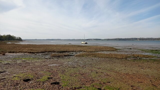
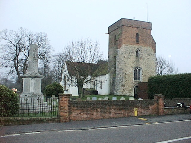
Ballast Hill, located in Essex, is a coastal marshland and salting situated along the coastline. It is a prominent geographical feature that holds significant historical and ecological value. The hill is characterized by its unique landscape, formed by the deposition of ballast rocks brought by ships during the 19th century.

The coastal marsh encompasses an area of approximately 100 acres and is bounded by the sea on one side and a network of creeks on the other. The topography of the hill is relatively flat, with a gradual slope towards the sea. It is covered by a diverse range of vegetation, including salt-tolerant grasses, reeds, and shrubs, which thrive in the brackish conditions.

Ballast Hill serves as an important habitat for various species of flora and fauna. The marshland is home to a variety of bird species, including wading birds like curlews, redshanks, and avocets, which migrate to the area during different seasons. The saltings also support a diverse range of marine life, such as fish, crabs, and various invertebrates.

The site holds historical significance as it served as a ballast site during the peak of maritime trade in the 19th century. Ships arriving from distant shores would discharge their ballast rocks to make space for cargo. Over time, these rocks accumulated, creating the distinct landscape that we see today.

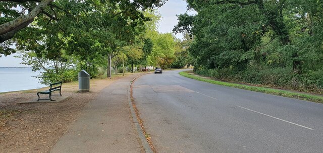
Ballast Hill, with its unique geography and ecological importance, attracts visitors who appreciate its natural beauty and historical context. The area offers opportunities for birdwatching, nature walks, and photography, allowing people to immerse themselves in the serene and picturesque surroundings.

If you have any feedback on the listing, please let us know in the comments section below.

Ballast Hill Images

Images are sourced within 2km of 51.948544/1.1000613 or Grid Reference TM1332. Thanks to Geograph Open Source API. All images are credited.

View of St. Mary & St. Michael's Church in Mistley from The Walls Looking south-southeast.
View of St. Mary & St. Michael's Church in Mistley from The Walls
Looking south-southeast.
View of Mistley Towers from the village square Looking north-northeast.
View of Mistley Towers from the village square
Looking north-northeast.
View of the EDME Malt Extract chimney towering above a house in Mistley from the village square Looking south-southeast.
View of the EDME Malt Extract chimney towering above a house in Mistley from the village square
Looking south-southeast.
View of the fingerpost sign on a bench in the village square Looks like a vehicle has crashed into the traditional fingerpost sign (as well as a nearby lamp post) on Mistley's village square and, rather ingeniously, the sign has been maintained by someone placing it on the nearby bench. Looking south-southwest.
View of the fingerpost sign on a bench in the village square
Looks like a vehicle has crashed into the traditional fingerpost sign (as well as a nearby lamp post) on Mistley's village square and, rather ingeniously, the sign has been maintained by someone placing it on the nearby bench. Looking south-southwest.
Mistley, St Mary & St Michael
Old Milestone, B1352, High Street, Mistley The milestone was originally located on the High Street, Mistley at TM 1181 3178. It was later moved against the wall of a building on Mistley Quay, see <a title="https://www.geograph.org.uk/photo/6045295" href="https://www.geograph.org.uk/photo/6045295">Link</a> , then temporarily put in to store during property development, and has now been re-installed in the Swan Basin, High Street. Parish of Mistley (Tendring District), Carved stone post, originally erected in the 19th century. A replacement for the cast iron post that would later have been fitted to the milestone is located close by, see <a title="https://www.geograph.org.uk/photo/7148738" href="https://www.geograph.org.uk/photo/7148738">Link</a>

Inscription reads:-
LXI / Colchester / 10 / Mistley  : : (Harwich / 11)

Milestone Society National ID: EX_COHH61
Old Milestone, B1352, High Street, Mistley
The milestone was originally located on the High Street, Mistley at TM 1181 3178. It was later moved against the wall of a building on Mistley Quay, see Link , then temporarily put in to store during property development, and has now been re-installed in the Swan Basin, High Street. Parish of Mistley (Tendring District), Carved stone post, originally erected in the 19th century. A replacement for the cast iron post that would later have been fitted to the milestone is located close by, see Link Inscription reads:- LXI / Colchester / 10 / Mistley : : (Harwich / 11) Milestone Society National ID: EX_COHH61
Replacement Milestone, B1352, High St, Mistley, Swan Basin This milestone is located in the Swan Basin, against the far wall to the right of the original stone milestone EX_COHH61, <a title="https://www.geograph.org.uk/photo/7148662" href="https://www.geograph.org.uk/photo/7148662">Link</a>. Parish of Mistley (Tendring District). It is a replacement for the original cast iron post, Bendall iron casting design, erected by the Essex Second District turnpike trust in the 19th century. Cast iron posts on this Colchester to Harwich route were made to be bolted on to the original stone milestones.

Inscription reads:-
HARWICH / 11  : : COLCHESTER / 10  : :  MISTLEY / TO / LONDON / 61  :  : BENDALL / IRON AND BRASS / FOUNDERS / PLOUGH AND MACHINE / MAKER / LAWFORD / ESSEX /1834

Milestone Society National ID: EX_COHH61AR
Replacement Milestone, B1352, High St, Mistley, Swan Basin
This milestone is located in the Swan Basin, against the far wall to the right of the original stone milestone EX_COHH61, Link. Parish of Mistley (Tendring District). It is a replacement for the original cast iron post, Bendall iron casting design, erected by the Essex Second District turnpike trust in the 19th century. Cast iron posts on this Colchester to Harwich route were made to be bolted on to the original stone milestones. Inscription reads:- HARWICH / 11 : : COLCHESTER / 10 : : MISTLEY / TO / LONDON / 61 : : BENDALL / IRON AND BRASS / FOUNDERS / PLOUGH AND MACHINE / MAKER / LAWFORD / ESSEX /1834 Milestone Society National ID: EX_COHH61AR
The Walls, Manningtree
Mistley war memorial and Mistley Tower
Boat on the River Stour A sailboat on the River Stour at low tide.
Boat on the River Stour
A sailboat on the River Stour at low tide.
Farmland by the Stour Estuary
Church of St Mary; Mistley; as seen from Stour Estuary
Stream in New Mistley The stream ends up in the Landooze Rill in the Stour. I suspect the land behind the fence will soon be re-developed.
Stream in New Mistley
The stream ends up in the Landooze Rill in the Stour. I suspect the land behind the fence will soon be re-developed.
A Glimpse of the Stour The CCTV cameras of  the Wharf in New Mistley can just be seen at the bottom of the frame. The weather coming from Suffolk looked ominous (and it was).
A Glimpse of the Stour
The CCTV cameras of the Wharf in New Mistley can just be seen at the bottom of the frame. The weather coming from Suffolk looked ominous (and it was).
Allotments in New Mistley A scrap of land between the B1352 and the railway.
Allotments in New Mistley
A scrap of land between the B1352 and the railway.
The Wharf at New Mistley Taken through the locked gates to the wharf
The Wharf at New Mistley
Taken through the locked gates to the wharf
Mistley Station
Mistley Station
Show me another place!

Ballast Hill is located at Grid Ref: TM1332 (Lat: 51.948544, Lng: 1.1000613)

Administrative County: Essex

District: Tendring

Police Authority: Essex

What 3 Words

///woodstove.newsprint.trades. Near Mistley, Essex

Related Wikis

Bradfield railway station

Bradfield railway station served the village of Bradfield in Essex. It was on the Manningtree to Harwich branch line, which is today known as The Mayflower...

Mistley

Mistley is a village and civil parish in the Tendring district of northeast Essex, England. It is around 11 miles northeast of Colchester and is east of...

Mistley railway station

Mistley railway station is on the Mayflower Line, a branch of the Great Eastern Main Line in the East of England, serving the village of Mistley, Essex...

Mistley Towers

Mistley Towers are the twin towers of the now demolished Church of St. Mary the Virgin at Mistley in Essex (sometimes known as Mistley Thorn(e) Church...

Bradfield, Essex

Bradfield is a village and civil parish in Essex, England. It is located about 3 miles (5 km) east of Manningtree and is 31 miles (50 km) northeast from...

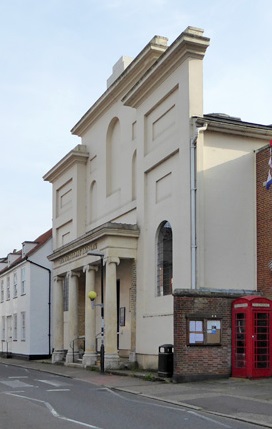
Corn Exchange, Manningtree

The Corn Exchange is a commercial building in the High Street in Manningtree, Essex, England. The structure, which is now used as a public library, is...

Manningtree

Manningtree is a town and civil parish in the Tendring district of Essex, England, which lies on the River Stour. It is part of the Suffolk Coast and Heaths...

Brantham Athletic F.C.

Brantham Athletic Football Club is a football club based in Brantham, Suffolk, England. They are currently members of the Eastern Counties League Premier...

Nearby Amenities

Located within 500m of 51.948544,1.1000613
Seamark Beacon Cardinal Category: north
Seamark Beacon Cardinal Colour: black;yellow
Seamark Light Character: Q
Seamark Light Colour: white
Seamark Light Reference: A 2222.6
Seamark Name: No. 12
Seamark Type: beacon_cardinal
Lat/Long: 51.9488613/1.0998735
Seamark Buoy Lateral Category: starboard
Seamark Buoy Lateral Colour: green
Seamark Buoy Lateral Shape: conical
Seamark Buoy Lateral System: iala-a
Seamark Light Character: Q
Seamark Light Colour: green
Seamark Name: No. 11
Seamark Type: buoy_lateral
Lat/Long: 51.9496482/1.1027638
The data included in this document is from www.openstreetmap.org. The data is made available under ODbL.

Have you been to Ballast Hill?

Leave your review of Ballast Hill below (or comments, questions and feedback).