Geo of Garth

Coastal Feature, Headland, Point in Shetland

Scotland

Geo of Garth

Noss ferry approaching the Bressay shore
Noss ferry approaching the Bressay shore Credit: Mike Pennington

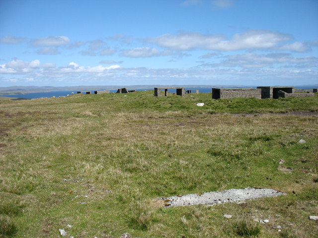
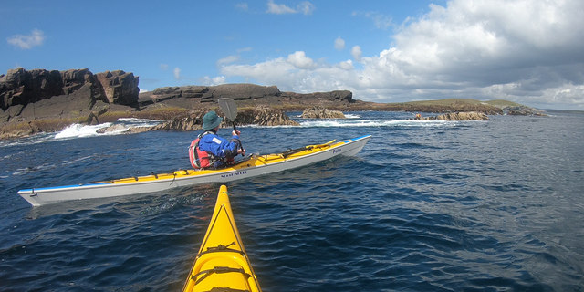
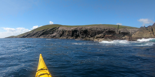
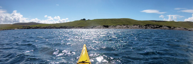
Geo of Garth is a prominent coastal feature located in the Shetland Islands, an archipelago in Scotland. Specifically, it is situated on the east coast of the Shetland Mainland, near the village of Cunningsburgh. Geo of Garth is a headland that juts out into the North Sea, forming a distinct point along the coastline.

The headland is characterized by its rugged and rocky terrain, with steep cliffs that plunge dramatically into the sea. These cliffs are composed of sedimentary rocks, predominantly sandstone and shale, which showcase intricate layers and patterns formed over millions of years. The exposed rocks also provide a glimpse into the geological history of the area, with fossils occasionally found embedded within them.

Geo of Garth offers spectacular views of the surrounding coastline and the vast expanse of the North Sea. From the headland, visitors can witness the powerful waves crashing against the cliffs, creating a mesmerizing display of nature's force. The area is also renowned for its diverse marine life, with seabirds such as puffins, guillemots, and fulmars nesting on the cliffs, and seals often seen basking on nearby rocks.

Access to Geo of Garth is relatively easy, with a footpath leading to the headland from the nearby village. The site is popular among locals and tourists alike, as it provides an ideal location for coastal walks, birdwatching, and photography. Furthermore, the wild and untamed beauty of Geo of Garth serves as a reminder of the raw power and majesty of the natural world.

If you have any feedback on the listing, please let us know in the comments section below.

Geo of Garth Images

Images are sourced within 2km of 60.161928/-1.0602558 or Grid Reference HU5242. Thanks to Geograph Open Source API. All images are credited.

Noss ferry approaching the Bressay shore
Gungstie, Noss, from Noss Sound
Noss-sound, Bressay, from Noss Sound
Noss National Nature Reserve Taken from a tour boat moored in Nesti Voe, Noss, Shetland, I am looking west to Big Ness where the wardens of Noss National Nature Reserve are located. NatureScot operates an inflatable ferry boat across Noss Sound (beyond the buildings pictured) during the summer months to allow walkers to get from Bressay to Noss.
Noss National Nature Reserve
Taken from a tour boat moored in Nesti Voe, Noss, Shetland, I am looking west to Big Ness where the wardens of Noss National Nature Reserve are located. NatureScot operates an inflatable ferry boat across Noss Sound (beyond the buildings pictured) during the summer months to allow walkers to get from Bressay to Noss.
Gungstie, Noss I am looking back as we leave Noss Sound, Shetland, on our way back to Lerwick.  The rocky outcrop of Gungstie is to the right of shot and the distinctive Hill of Setter (to the south of Noss) can be seen in the distance.
Gungstie, Noss
I am looking back as we leave Noss Sound, Shetland, on our way back to Lerwick. The rocky outcrop of Gungstie is to the right of shot and the distinctive Hill of Setter (to the south of Noss) can be seen in the distance.
The lane to Setter, Bressay Running across the slopes of the Hill of Setter.
The lane to Setter, Bressay
Running across the slopes of the Hill of Setter.
The summit of the Hill of Setter, Bressay With the remains of a World War II anti-aircraft battery.
The summit of the Hill of Setter, Bressay
With the remains of a World War II anti-aircraft battery.
Skerry-hopping at Loder Head Last time I'd been to Bressay nine years ago, we didn't even get round the corner to see Noss, as the wind was too much. On this trip, despite a spell of bad weather as we came to Shetland on the ferry, the wind had dropped dramatically by our second day, and the east side of Shetland was relatively protected from the big swells. Coming round the top of Bressay, there was still enough for rock-hopping (paddling over reefs and rocks that would be too shallow without the help of a wave and good timing) but it was unpredictable enough (the result of two separate swell directions interfering producing occasional big waves) that sport was certainly to be had. The first through this gap had been caught by a bigger set as he came over, then three of us had popped through before the next set arrived. The last paddler has dropped back a little to wait for the next calmer spell and is just about to make her way through.
Skerry-hopping at Loder Head
Last time I'd been to Bressay nine years ago, we didn't even get round the corner to see Noss, as the wind was too much. On this trip, despite a spell of bad weather as we came to Shetland on the ferry, the wind had dropped dramatically by our second day, and the east side of Shetland was relatively protected from the big swells. Coming round the top of Bressay, there was still enough for rock-hopping (paddling over reefs and rocks that would be too shallow without the help of a wave and good timing) but it was unpredictable enough (the result of two separate swell directions interfering producing occasional big waves) that sport was certainly to be had. The first through this gap had been caught by a bigger set as he came over, then three of us had popped through before the next set arrived. The last paddler has dropped back a little to wait for the next calmer spell and is just about to make her way through.
Geo of Vatsvie More of an embayment than a deep cleft, the Geo of Vatsvie cuts into Old Red Sandstone on the east coast of Bressay's Loder Head peninsula. There's swell coming in from the east, reflecting off the foot of the rocks and rushing back towards the kayak which always makes getting in close fun. Not far ahead the Island of Noss starts to provide more shelter and the sea becomes pretty much flat - great for nervous tourists on the tiny RIB passenger ferry, but  a bit dull for sea kayaks. The opposite side of Noss was to provide a lot more excitement...
Geo of Vatsvie
More of an embayment than a deep cleft, the Geo of Vatsvie cuts into Old Red Sandstone on the east coast of Bressay's Loder Head peninsula. There's swell coming in from the east, reflecting off the foot of the rocks and rushing back towards the kayak which always makes getting in close fun. Not far ahead the Island of Noss starts to provide more shelter and the sea becomes pretty much flat - great for nervous tourists on the tiny RIB passenger ferry, but a bit dull for sea kayaks. The opposite side of Noss was to provide a lot more excitement...
Getting onto the Noss ferry Whilst the Bressay ferry used to get here takes vehicles and has a "proper" dock, the Noss ferry is only for very small numbers of pedestrians, so needs no more than a set of steps down to sea level. There's no timetable - when the ferryman notices that there are people waiting, he will come across to get them. Whether this works on foggy days is another question entirely, and not one we needed answered, as we were visiting in our own boats, just popping over to look at the ferry terminal out of curiosity.
Getting onto the Noss ferry
Whilst the Bressay ferry used to get here takes vehicles and has a "proper" dock, the Noss ferry is only for very small numbers of pedestrians, so needs no more than a set of steps down to sea level. There's no timetable - when the ferryman notices that there are people waiting, he will come across to get them. Whether this works on foggy days is another question entirely, and not one we needed answered, as we were visiting in our own boats, just popping over to look at the ferry terminal out of curiosity.
Paddling down Noss Sound Somehow, using a map, one always thinks of heading south as "down" though, of course, on average, the sea is level, and as we were going against the very start of the flood tide we might actually be going a tiny bit uphill ! Tidal flows at Noss are generally insignificant except in this shallow channel, and we were going anticlockwise round the island more to have the sun behind us on the scenic side than to take any advantage of the flow. The boat powering away from us had been stationary as we arrived, but seemed to form a sudden desire to leave as (or perhaps before) their clients realised just how much closer to the wildlife sea kayakers can get than anyone in a big boat. The Sound had already given us close encounters with Seals, Eider, Cormorants and Terns diving in just metres away. The outer side promised huge numbers of Gannets and Razorbills...
Paddling down Noss Sound
Somehow, using a map, one always thinks of heading south as "down" though, of course, on average, the sea is level, and as we were going against the very start of the flood tide we might actually be going a tiny bit uphill ! Tidal flows at Noss are generally insignificant except in this shallow channel, and we were going anticlockwise round the island more to have the sun behind us on the scenic side than to take any advantage of the flow. The boat powering away from us had been stationary as we arrived, but seemed to form a sudden desire to leave as (or perhaps before) their clients realised just how much closer to the wildlife sea kayakers can get than anyone in a big boat. The Sound had already given us close encounters with Seals, Eider, Cormorants and Terns diving in just metres away. The outer side promised huge numbers of Gannets and Razorbills...
Landing on Noss Although, coming from Voe of Cullingsborough round Loder Head, we hadn't paddled very far to reach Noss, the island offers few other landing places apart from the west side, facing Bressay across Noss Sound. Thus our group stopped for an early lunch in anticipation that we would be on the water for rather longer to complete our trip all the way round. This beach is just north of the tourist ferry landing, out of their way, and even seemed quite sheltered (we'd had a very windy 24 hours the previous day and the open sea was still quite lumpy, whilst here in the Sound it was essentially flat).
Landing on Noss
Although, coming from Voe of Cullingsborough round Loder Head, we hadn't paddled very far to reach Noss, the island offers few other landing places apart from the west side, facing Bressay across Noss Sound. Thus our group stopped for an early lunch in anticipation that we would be on the water for rather longer to complete our trip all the way round. This beach is just north of the tourist ferry landing, out of their way, and even seemed quite sheltered (we'd had a very windy 24 hours the previous day and the open sea was still quite lumpy, whilst here in the Sound it was essentially flat).
Southwest shore, Voe of Cullingsborough Although the Voe of Cullingsborough looks sheltered, there is a low pass through the island of Bressay just to its south and today's southerly wind was being canalised through the gap, giving us the strongest headwind of our day's paddle round Noss. A somewhat unexpected end to a day where we'd anticipated the most challenging conditions to be out on the open coast. However, it's not far to go now - the landing is on the little shingle beach on the left of the photo, which lies just below the end of the public road, and the parked cars of both our group of sea kayakers and another, bigger group, who'd gone round the other way and were not far behind us.
Southwest shore, Voe of Cullingsborough
Although the Voe of Cullingsborough looks sheltered, there is a low pass through the island of Bressay just to its south and today's southerly wind was being canalised through the gap, giving us the strongest headwind of our day's paddle round Noss. A somewhat unexpected end to a day where we'd anticipated the most challenging conditions to be out on the open coast. However, it's not far to go now - the landing is on the little shingle beach on the left of the photo, which lies just below the end of the public road, and the parked cars of both our group of sea kayakers and another, bigger group, who'd gone round the other way and were not far behind us.
Rounding Big Ness into Nesti Voe Big Ness is really quite a small peninsula, ending in these low shoreline rocks. Beyond to the left is Nesti Voe, with a big beach, but an onshore wind, so not what we wanted for a lunch stop. Across the Voe is Turr Ness, a somewhat rockier and longer peninsula with enough height to conceal our onward route to reach the east coast of Noss. The hill in partial shadow is Hill of Setter, rising to 181m directly above the cliffs and gannetry of Noss Head, though you'd scarcely guess that seeing it from the west. The whole island is a nature reserve, gentle slopes being mainly inhabited by chaps in camouflage jackets carrying large cameras and even bigger tripods. Must be something worthwhile to see then, so let's keep paddling !
Rounding Big Ness into Nesti Voe
Big Ness is really quite a small peninsula, ending in these low shoreline rocks. Beyond to the left is Nesti Voe, with a big beach, but an onshore wind, so not what we wanted for a lunch stop. Across the Voe is Turr Ness, a somewhat rockier and longer peninsula with enough height to conceal our onward route to reach the east coast of Noss. The hill in partial shadow is Hill of Setter, rising to 181m directly above the cliffs and gannetry of Noss Head, though you'd scarcely guess that seeing it from the west. The whole island is a nature reserve, gentle slopes being mainly inhabited by chaps in camouflage jackets carrying large cameras and even bigger tripods. Must be something worthwhile to see then, so let's keep paddling !
Coastguard Lookout, Ander Hill from Setter, Bressay Historic Environment Scotland Scheduled Monument the Admiralty lookout station was built between 1912 and 1917. In addition to the tower, an underground shelter, accessed by a ground-level trapdoor, a cast-iron water-pump and a concrete footing with the remains of a wooden signalling pole survive in close proximity. The now floorless concrete tower commands fantastic views reaching as far as Foula and Sumburgh Head on a fine day. The building was in use as a coastguard lookout until it was abandoned in 1969.
Coastguard Lookout, Ander Hill from Setter, Bressay
Historic Environment Scotland Scheduled Monument the Admiralty lookout station was built between 1912 and 1917. In addition to the tower, an underground shelter, accessed by a ground-level trapdoor, a cast-iron water-pump and a concrete footing with the remains of a wooden signalling pole survive in close proximity. The now floorless concrete tower commands fantastic views reaching as far as Foula and Sumburgh Head on a fine day. The building was in use as a coastguard lookout until it was abandoned in 1969.
Ander Hill, Bressay, from Noss Sound
Mansie's Berg, Noss, from the sea
The Noss ferry on the Bressay side of Noss Sound
Show me another place!

Geo of Garth is located at Grid Ref: HU5242 (Lat: 60.161928, Lng: -1.0602558)

Unitary Authority: Shetland Islands

Police Authority: Highlands and Islands

What 3 Words

///stepping.limelight.media. Near Lerwick, Shetland Islands

Related Wikis

Broch of Cullingsburgh

The Broch of Cullingsburgh is an Iron Age broch located in the Shetland islands. == Location == Located on Bressay, off the east coast of mainland Shetland...

Voe of Cullingsburgh

Voe of Cullingsburgh is a large sea loch off the Shetland island of Bressay, voe meaning "sea inlet" in Shetland dialect. The local spelling of the name...

Bressay

Bressay (Scots: Bressa) is a populated island in the Shetland archipelago of Scotland. == Geography and geology == Bressay lies due south of Whalsay, west...

Isle of Noss

The Isle of Noss or Noss (Scots: Noss) is a small, previously inhabited island in Shetland, Scotland. Noss is separated from the island of Bressay by the...

Gardie House

Gardie House is an 18th-century estate house on Bressay in Shetland, Scotland. Located opposite Lerwick, across the Bressay Sound, Gardie is described...

Bressay transmitting station

Bressay transmitting station is a broadcasting transmission facility for the Shetland Islands, located on the isle of Bressay, owned and operated by Arqiva...

Holm of Noss

The Holm of Noss or Cradle Holm is an uninhabited islet of the Shetland Islands. It is about 48m at its highest point. == Geography and geology == It is...

Lerwick and Bressay Parish Church

Lerwick and Bressay Parish Church is the largest Church of Scotland congregation in Shetland, serving the islands' capital Lerwick and the surrounding...

Nearby Amenities

Located within 500m of 60.161928,-1.0602558
Entrance: yes
Lat/Long: 60.1616405/-1.0629916
Pow of Cullingsburgh
Natural: bay
Lat/Long: 60.1601091/-1.0670257
Bay of Cuppa
Natural: bay
Lat/Long: 60.1624259/-1.0580778
The data included in this document is from www.openstreetmap.org. The data is made available under ODbL.

Have you been to Geo of Garth?

Leave your review of Geo of Garth below (or comments, questions and feedback).