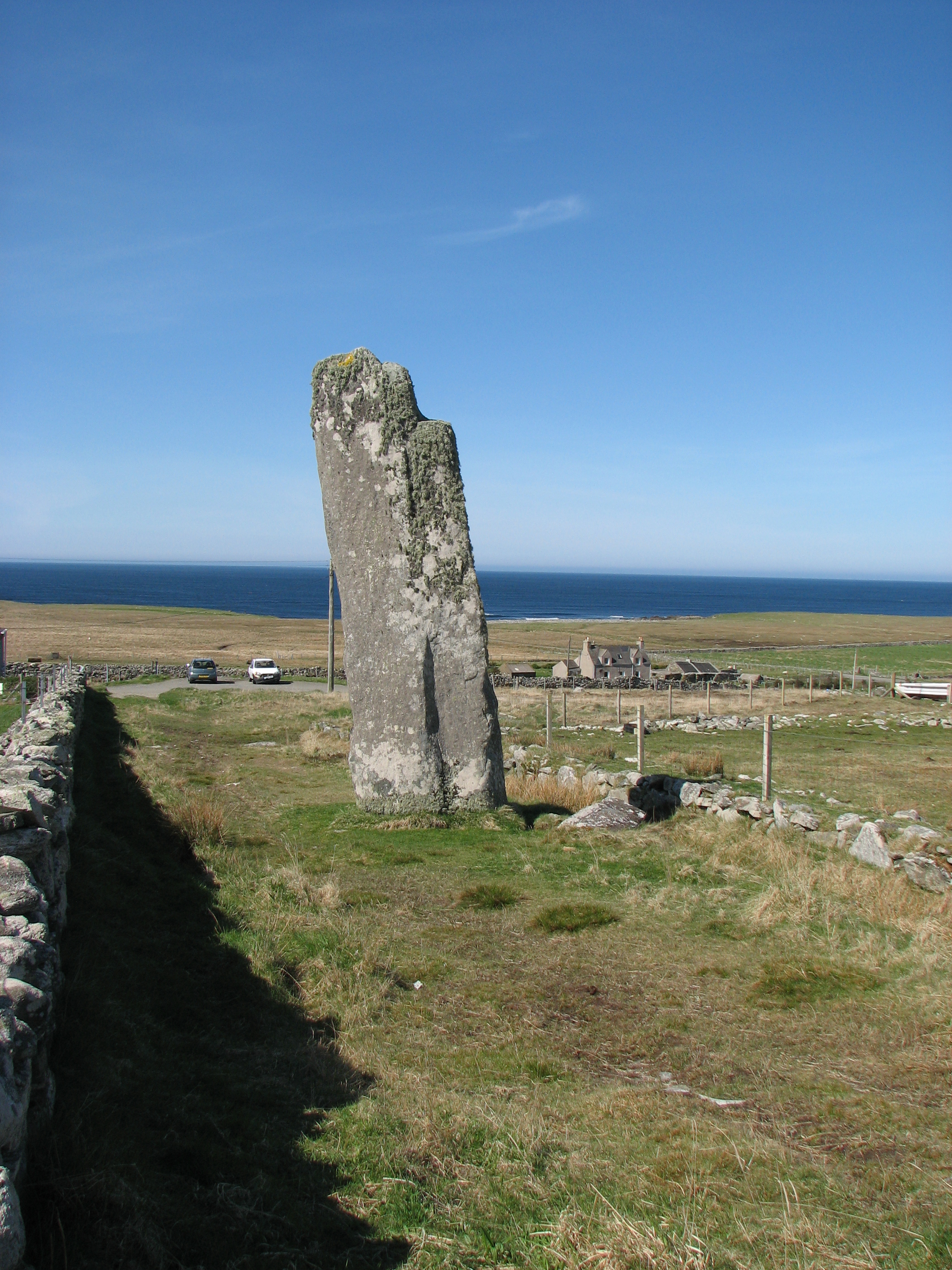
Stac na Caillich

Coastal Feature, Headland, Point in Ross-shire

Scotland

Stac na Caillich

Baile an Truiseil
Baile an Truiseil Credit: Mick Garratt

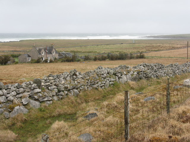
Stac na Caillich is a prominent coastal feature located in Ross-shire, Scotland. It is a headland or point that juts out into the North Sea, offering stunning views of the surrounding area. Standing at an impressive height of approximately 100 meters (328 feet), it serves as a remarkable landmark in the region.

The name "Stac na Caillich" translates to "Stack of the Old Woman" in Gaelic, which alludes to the legend associated with the site. According to local folklore, the stack was formed when an old witch was turned to stone by a powerful wizard. This mythical tale has contributed to the intrigue surrounding Stac na Caillich and adds to its allure.

Geologically, Stac na Caillich is composed of rugged cliffs and rocky outcrops, which provide a habitat for various bird species, including seabirds like gannets and fulmars. The headland is also known for its diverse flora, with heather and grasses covering the exposed slopes.

Visitors to Stac na Caillich can enjoy panoramic views of the North Sea, as well as the surrounding coastal landscape. The headland offers an ideal vantage point for birdwatching and photography enthusiasts, who can capture the beauty of the area's wildlife and natural scenery.

Access to Stac na Caillich is relatively straightforward, with a well-maintained coastal path leading to the headland. However, it is important to exercise caution while exploring the area, as the cliffs can be steep and exposed. Nonetheless, the journey to Stac na Caillich is well worth the effort for those seeking a captivating coastal experience in Ross-shire.

If you have any feedback on the listing, please let us know in the comments section below.

Stac na Caillich Images

Images are sourced within 2km of 58.393601/-6.5218792 or Grid Reference NB3553. Thanks to Geograph Open Source API. All images are credited.

Baile an Truiseil
Baile an Truiseil
Windfarm near Borve
Windfarm near Borve
Wind turbines at Druim nan Carnan
Clach an Truiseil Geograph-er attempts to correct the lean on this giant standing stone - at 5.8 metres, the tallest in Scotland
Clach an Truiseil
Geograph-er attempts to correct the lean on this giant standing stone - at 5.8 metres, the tallest in Scotland
Clach an Truiseil At 5.8 metres, the highest standing stone in Scotland.
Clach an Truiseil
At 5.8 metres, the highest standing stone in Scotland.
Clach An Trushal The tallest standing stone in Scotland once probably formed part of a stone circle. <span class="nowrap"><a title="https://canmore.org.uk/site/4264/lewis-clach-an-trushal" rel="nofollow ugc noopener" href="https://canmore.org.uk/site/4264/lewis-clach-an-trushal">Link</a><img style="margin-left:2px;" alt="External link" title="External link - shift click to open in new window" src="https://s1.geograph.org.uk/img/external.png" width="10" height="10"/></span>
Clach An Trushal
The tallest standing stone in Scotland once probably formed part of a stone circle. LinkExternal link
Roofless Blackhouse at Baile an Truiseil
Trussel Stone / Clach an Truiseil Beside a holiday cottage is this prehistoric standing stone, reputed to be Scotland's tallest. It is some 6 metres in height.
<span class="nowrap"><a title="http://www.megalithic.co.uk/article.php?sid=51" rel="nofollow ugc noopener" href="http://www.megalithic.co.uk/article.php?sid=51">Link</a><img style="margin-left:2px;" alt="External link" title="External link - shift click to open in new window" src="https://s1.geograph.org.uk/img/external.png" width="10" height="10"/></span>
Trussel Stone / Clach an Truiseil
Beside a holiday cottage is this prehistoric standing stone, reputed to be Scotland's tallest. It is some 6 metres in height. LinkExternal link
Clach an Truiseil Standing Stone At 5.8 metres, or nearly 19 feet in old money, this is the tallest menhir in Scotland.
Clach an Truiseil Standing Stone
At 5.8 metres, or nearly 19 feet in old money, this is the tallest menhir in Scotland.
Rocks and cliffs at Barabhas Looking north to Stac na Faoileig from Tòl Mòr.
Rocks and cliffs at Barabhas
Looking north to Stac na Faoileig from Tòl Mòr.
Pasture on Tòl Mòr The wet and windswept western seaboard of the Isle of Lewis
Pasture on Tòl Mòr
The wet and windswept western seaboard of the Isle of Lewis
Fields on the sand dunes at Tòl Mòr
House at Baile an Truiseil Looking north from near the monolith of Clach an Truiseil, with the sea at Siorrabhaig beyond.
House at Baile an Truiseil
Looking north from near the monolith of Clach an Truiseil, with the sea at Siorrabhaig beyond.
Clach an Truiseil The dark side of this huge, 5.8 m tall standing stone, covered in lichens. It has been here for about 5000 years, and is the last stone of what was a stone circle complex - the rest had been used for building walls and houses by about the end of the 19thC. <span class="nowrap"><a title="http://canmore.rcahms.gov.uk/en/site/4264/details/lewis+clach+an+trushal/" rel="nofollow ugc noopener" href="http://canmore.rcahms.gov.uk/en/site/4264/details/lewis+clach+an+trushal/">Link</a><img style="margin-left:2px;" alt="External link" title="External link - shift click to open in new window" src="https://s1.geograph.org.uk/img/external.png" width="10" height="10"/></span>
Clach an Truiseil
The dark side of this huge, 5.8 m tall standing stone, covered in lichens. It has been here for about 5000 years, and is the last stone of what was a stone circle complex - the rest had been used for building walls and houses by about the end of the 19thC. LinkExternal link
Clach an Truiseil The south side of this huge, 5.8 m tall, standing stone, covered in lichens. It has been here for about 5000 years, and is the last stone of what was a stone circle complex - the rest had been used for building walls and houses by about the end of the 19thC. <span class="nowrap"><a title="http://canmore.rcahms.gov.uk/en/site/4264/details/lewis+clach+an+trushal/" rel="nofollow ugc noopener" href="http://canmore.rcahms.gov.uk/en/site/4264/details/lewis+clach+an+trushal/">Link</a><img style="margin-left:2px;" alt="External link" title="External link - shift click to open in new window" src="https://s1.geograph.org.uk/img/external.png" width="10" height="10"/></span>
Clach an Truiseil
The south side of this huge, 5.8 m tall, standing stone, covered in lichens. It has been here for about 5000 years, and is the last stone of what was a stone circle complex - the rest had been used for building walls and houses by about the end of the 19thC. LinkExternal link
Remains of a stone house A few metres from Clach an Truiseil, and probably using some of the stones from the circle complex. One of three views.
Remains of a stone house
A few metres from Clach an Truiseil, and probably using some of the stones from the circle complex. One of three views.
Old stone cottage by Clach an Truseil A few metres from Clach an Truiseil, and probably using some of the stones from the circle complex. One of three views.
Old stone cottage by Clach an Truseil
A few metres from Clach an Truiseil, and probably using some of the stones from the circle complex. One of three views.
Ruined cottage at Baile an Truiseil A few metres from Clach an Truiseil, and probably using some of the stones from the circle complex. One of three views.
Ruined cottage at Baile an Truiseil
A few metres from Clach an Truiseil, and probably using some of the stones from the circle complex. One of three views.
Show me another place!

Stac na Caillich is located at Grid Ref: NB3553 (Lat: 58.393601, Lng: -6.5218792)

Unitary Authority: Na h-Eileanan an Iar

Police Authority: Highlands and Islands

What 3 Words

///seasick.pounces.scenes. Near North Tolsta, Na h-Eileanan Siar

Related Wikis

Clach an Trushal

Clach an Trushal (Scottish Gaelic: Clach an Truiseil, Scottish Gaelic pronunciation: [kʰl̪ˠax ən̪ˠ ˈt̪ʰɾuʃal], translated to English "Stone of Compassion...

Baile an Truiseil

Ballantrushal (Scottish Gaelic: Baile an Truiseil) is a village on the Isle of Lewis in the West Side district, in the Outer Hebrides, Scotland. Ballantrushal...

Steinacleit

Steinacleit is a prehistoric archeological site on the west coast of Lewis in the Outer Hebrides of Scotland. The site consists of an array of boulders...

Barvas

Barvas (Scottish Gaelic: Barabhas or Barbhas, pronounced [baravəs]) is a settlement, community and civil parish on the Isle of Lewis in Scotland. It developed...

Nearby Amenities

Located within 500m of 58.393601,-6.5218792
Created By: dmgroom_coastlines
Lat/Long: 58.3932/-6.52155
Created By: dmgroom_coastlines
Lat/Long: 58.39398/-6.52198
Created By: dmgroom_coastlines
Lat/Long: 58.39525/-6.52141
Rubha Leathann
Natural: cape
Lat/Long: 58.3967816/-6.5181852
Rubha na Caillich
Natural: cape
Lat/Long: 58.3949037/-6.5222407
The data included in this document is from www.openstreetmap.org. The data is made available under ODbL.

Have you been to Stac na Caillich?

Leave your review of Stac na Caillich below (or comments, questions and feedback).