Tide Rock

Coastal Feature, Headland, Point in Cornwall

England

Tide Rock

Lower Town Quay The smaller of the two quays on St Martin’s. The larger quay at Higher Town is the one used for freight deliveries, but is inaccessible at a low tide.

The island behind is the uninhabited Tean (pronounced tea-an).
Lower Town Quay Credit: David Lally

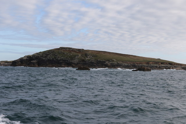
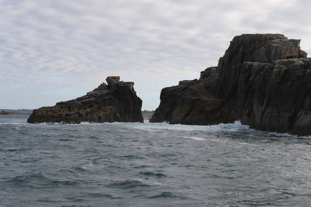
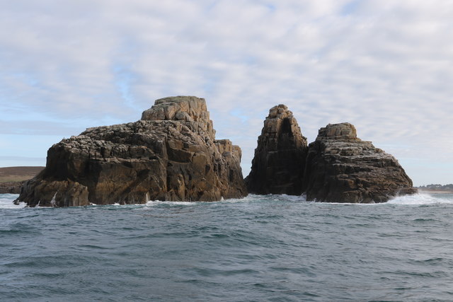
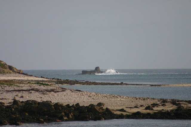
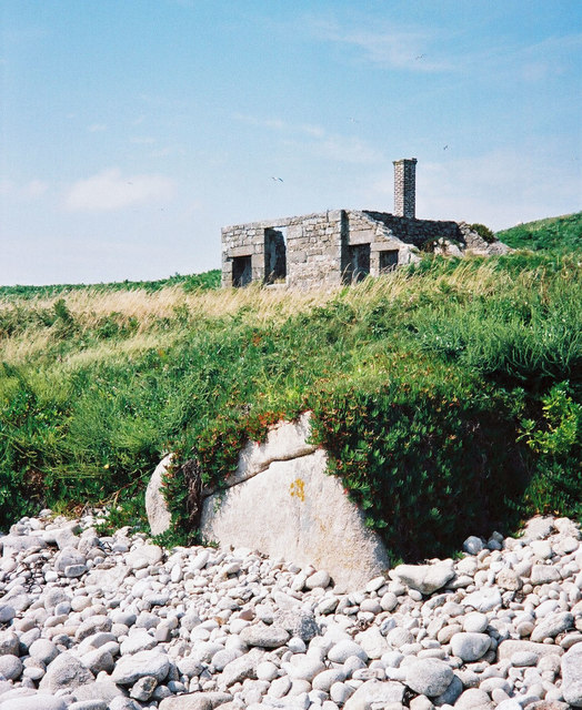
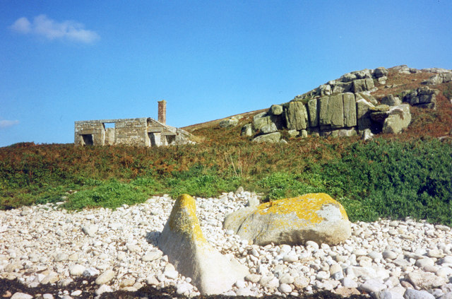
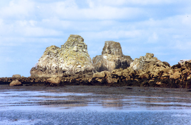
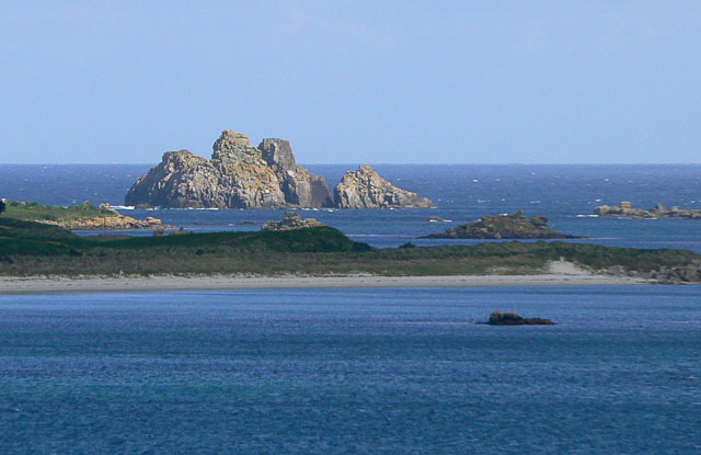
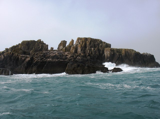
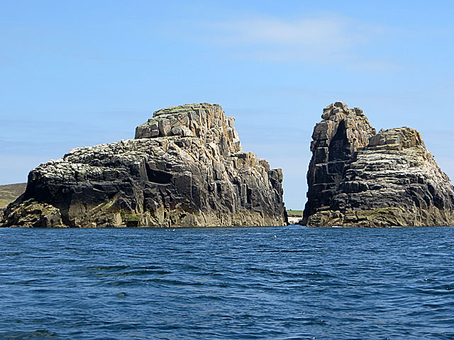
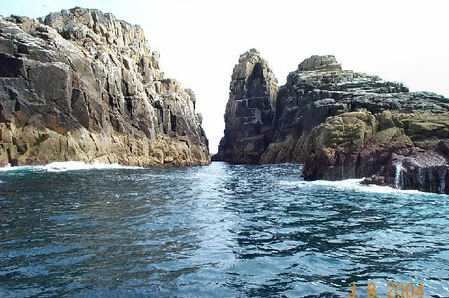
Tide Rock is a prominent coastal feature located in Cornwall, England. It is a headland that juts out into the Atlantic Ocean, forming a distinct point in the rugged coastline of the region. This natural formation is known for its unique geological composition and stunning views.

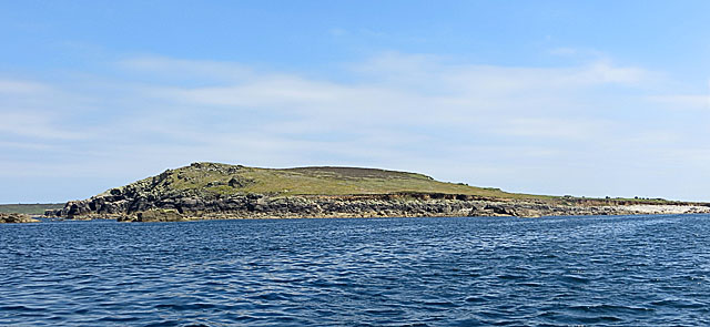
Situated near the small village of St. Ives, Tide Rock offers visitors a chance to witness the power of the ocean firsthand. The headland is made up of rugged cliffs, with the crashing waves of the Atlantic constantly battering against them. The constant erosion caused by the tides has sculpted the rocks into fascinating formations, creating a dramatic and awe-inspiring sight.

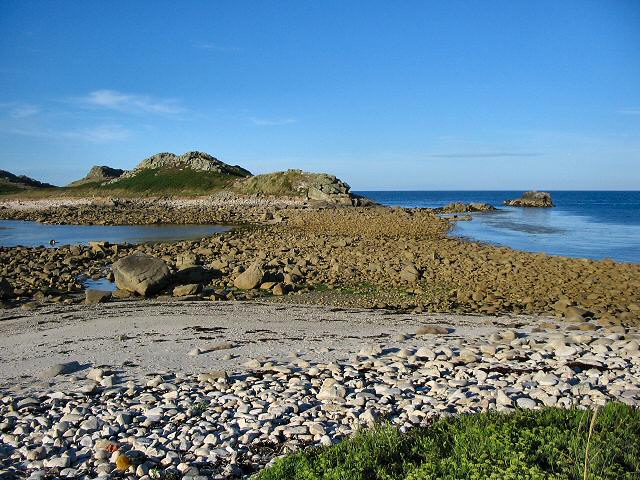
Tide Rock is a popular spot for outdoor enthusiasts and nature lovers. Its location provides a vantage point for observing marine life, including seals and various seabird species that call the area home. The headland is also a popular destination for hikers, offering breathtaking coastal walks and panoramic views of the surrounding landscape.

In addition to its natural beauty, Tide Rock also holds historical significance. It is believed to have been a landmark for sailors and fishermen in ancient times, guiding them safely along the treacherous coastline. Today, it serves as a reminder of Cornwall's rich maritime heritage.

Overall, Tide Rock is a captivating coastal feature that showcases the raw power of the ocean and offers visitors a chance to connect with nature and history. Its rugged cliffs, stunning views, and abundant wildlife make it a must-visit destination for anyone exploring the picturesque coastline of Cornwall.

If you have any feedback on the listing, please let us know in the comments section below.

Tide Rock Images

Images are sourced within 2km of 49.98115/-6.3115006 or Grid Reference SV9117. Thanks to Geograph Open Source API. All images are credited.

Lower Town Quay The smaller of the two quays on St Martin’s. The larger quay at Higher Town is the one used for freight deliveries, but is inaccessible at a low tide.

The island behind is the uninhabited Tean (pronounced tea-an).
Lower Town Quay
The smaller of the two quays on St Martin’s. The larger quay at Higher Town is the one used for freight deliveries, but is inaccessible at a low tide. The island behind is the uninhabited Tean (pronounced tea-an).
The north end of St Helen's From a boat trip around the north of the Isles of Scilly
The north end of St Helen's
From a boat trip around the north of the Isles of Scilly
Eastern gap in Men-a-Vaur From the north
Eastern gap in Men-a-Vaur
From the north
Men-a-Vaur From the north side
Men-a-Vaur
From the north side
Men-a-Vaur rocks From this view point Men-a-Vaur rocks look a little bit like a submarine in heavy weather
Men-a-Vaur rocks
From this view point Men-a-Vaur rocks look a little bit like a submarine in heavy weather
The Pest House, St Helen's An 18th century quarantine station for plague victims from passing ships who were isolated on this small island to await their fate. <span class="nowrap"><a title="https://en.wikipedia.org/wiki/St_Helen%27s,_Isles_of_Scilly" rel="nofollow ugc noopener" href="https://en.wikipedia.org/wiki/St_Helen%27s,_Isles_of_Scilly">Link</a><img style="margin-left:2px;" alt="External link" title="External link - shift click to open in new window" src="https://s1.geograph.org.uk/img/external.png" width="10" height="10"/></span>
The Pest House, St Helen's
An 18th century quarantine station for plague victims from passing ships who were isolated on this small island to await their fate. LinkExternal link
St Helen's Pest House The small quarantine shelter where sailors infected with the plague were marooned. A small graveyard is nearby which kind of tells its own story.
St Helen's Pest House
The small quarantine shelter where sailors infected with the plague were marooned. A small graveyard is nearby which kind of tells its own story.
Men-a-vaur The impressive rock stacks of Men-a-vaur rise almost vertically to over 30 metres. I spent a while with various Cornish language sites without coming up with a translation, apart from men = stone.
Men-a-vaur
The impressive rock stacks of Men-a-vaur rise almost vertically to over 30 metres. I spent a while with various Cornish language sites without coming up with a translation, apart from men = stone.
Men-a-Vaur seen from St Mary's, Scilly This unusual view of Men-a-Vaur was taken from the north coast of St Mary's using a telephoto. The sandy beach in the foreground is the south-east Tresco, including Skirt Island.
Men-a-Vaur seen from St Mary's, Scilly
This unusual view of Men-a-Vaur was taken from the north coast of St Mary's using a telephoto. The sandy beach in the foreground is the south-east Tresco, including Skirt Island.
Men-a-vaur A very impressive group, actually three rocky islets close together, to the north-west of the Isles of Scilly.
Men-a-vaur
A very impressive group, actually three rocky islets close together, to the north-west of the Isles of Scilly.
Men-a-Vaur from the north-west This view of the island looks between the two main stacks to St Helen's beyond.
Men-a-Vaur from the north-west
This view of the island looks between the two main stacks to St Helen's beyond.
The remains of the Pest House on St Helen's St Helens was the site of a quarantine house for plague built in 1764. Today, this is the only building now visible on the island from the sea, although there are also the remains of the priory and hermitage.
The remains of the Pest House on St Helen's
St Helens was the site of a quarantine house for plague built in 1764. Today, this is the only building now visible on the island from the sea, although there are also the remains of the priory and hermitage.
St Helen's from the North St Helen's is a low-lying island unlike some of the rocky islands further west and east. It is the home of several seabirds, but not in the numbers on the rockier islands
St Helen's from the North
St Helen's is a low-lying island unlike some of the rocky islands further west and east. It is the home of several seabirds, but not in the numbers on the rockier islands
Men-a-Vaur
Men-a-Vaur
Lower Town, St. Martin's Looking SW, Tresco in distance
Lower Town, St. Martin's
Looking SW, Tresco in distance
Looking out from gardens of Seven Stones pub View looking south from the pub
Looking out from gardens of Seven Stones pub
View looking south from the pub
The tidal causeway to White Island, Scilly White Island is a part of St Martin's. This is the only land based way onto the island.
The tidal causeway to White Island, Scilly
White Island is a part of St Martin's. This is the only land based way onto the island.
Lower Town quay, St Martin's - Scilly A small quay - but very well used for loading and unloading all the things that are essential for island life.
Lower Town quay, St Martin's - Scilly
A small quay - but very well used for loading and unloading all the things that are essential for island life.
Show me another place!

Tide Rock is located at Grid Ref: SV9117 (Lat: 49.98115, Lng: -6.3115006)

Division: Isles of Scilly

Unitary Authority: Isles of Scilly

Police Authority: Devon and Cornwall

What 3 Words

///iteration.downs.wrist. Near St Martin's, Isles of Scilly

Related Wikis

Round Island Light, Isles of Scilly

Round Island Lighthouse (Cornish: Golowji an Voth "the hump lighthouse"), in the Isles of Scilly was designed by William Tregarthen Douglass for Trinity...

St Helen's, Isles of Scilly

St Helen's (Cornish: Enys Elyd or Enys Elidius) is one of the fifty or so uninhabited islands in the archipelago of the Isles of Scilly and has an approximate...

White Island, Isles of Scilly

White Island (Cornish: Ar Nor, "facing the mainland" or Enys Wynn "white island" ) is one of the larger unpopulated islands of the Isles of Scilly, part...

Teän

Teän ( TEE-ən, sometimes written Tean without the diaeresis; Cornish: Enys Tian) is an uninhabited island to the north of the Isles of Scilly archipelago...

Lower Town, Isles of Scilly

Lower Town (Cornish: Trewoles) is the westernmost settlement on the island of St Martin's in the Isles of Scilly, England. One of the island's two quays...

Middle Town, St Martin's

Middle Town (Cornish: Tregres) is a small settlement on the island of St Martin's in the Isles of Scilly, England. It is situated slightly inland, approximately...

St Martin's, Isles of Scilly

St Martin's (Cornish: Brechiek, lit. 'dappled island') is the northernmost populated island of the Isles of Scilly, England, United Kingdom. It has an...

Piper's Hole

Piper's Hole is a sea cave located on Tresco, an island of the Isles of Scilly. The name Piper's Hole can also refer to another, more minor, sea cave in...

Have you been to Tide Rock?

Leave your review of Tide Rock below (or comments, questions and feedback).