High Force

Waterfall in Cumberland Eden

England

High Force

Dead tree near Groove Gill Dead tree near Groove Gill.
Dead tree near Groove Gill Credit: Colin Kinnear

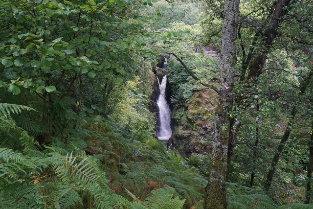
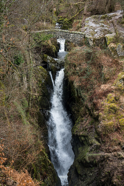
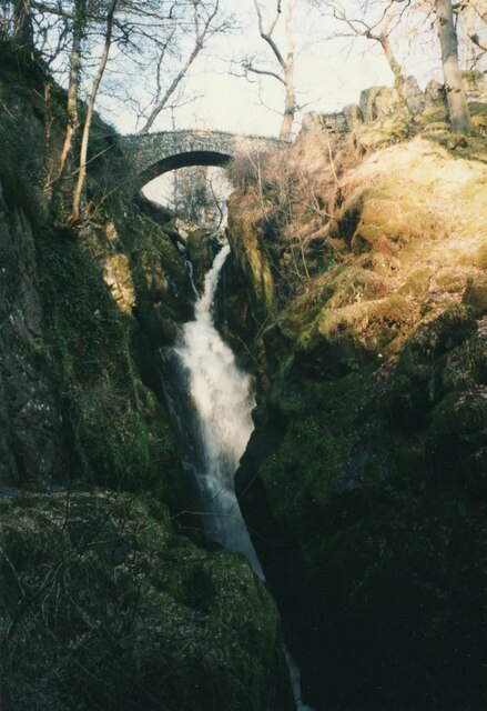
High Force is a spectacular waterfall located in the remote region of Upper Teesdale in Cumberland, England. It is situated within the North Pennines Area of Outstanding Natural Beauty, approximately 8 miles southwest of the town of Middleton-in-Teesdale. This natural wonder is considered one of the most impressive waterfalls in England, attracting thousands of visitors each year.

The waterfall is formed by the River Tees as it plunges over a limestone cliff, cascading down a drop of approximately 70 feet (21 meters) into a pool below. The sheer force and volume of water create a breathtaking sight that leaves visitors in awe of nature's power.

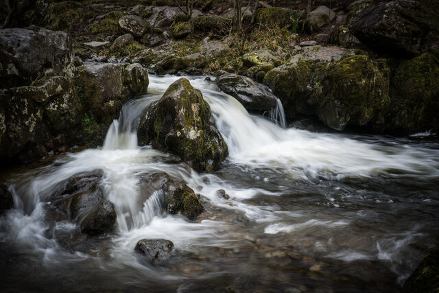
Surrounded by lush greenery and rugged landscapes, High Force offers a picturesque setting for nature enthusiasts and photographers alike. The area is also home to a diverse range of flora and fauna, including rare species of plants and birds.

Visitors can explore the waterfall and its surroundings via well-maintained footpaths and viewing platforms that provide excellent vantage points to admire the beauty of the falls. There is also a visitor center on-site, offering information about the local area, the geology, and the wildlife.

High Force is not only a popular tourist attraction but also a site of geological importance. The waterfall is part of the Whin Sill, a geological formation that stretches across the region and is known for its hard, igneous rock. This rock is responsible for the dramatic drop and distinct appearance of High Force.

Overall, High Force is a natural marvel that showcases the raw power and beauty of nature. It offers a serene escape from the hustle and bustle of everyday life, allowing visitors to immerse themselves in the tranquility and grandeur of this magnificent waterfall.

If you have any feedback on the listing, please let us know in the comments section below.

High Force Images

Images are sourced within 2km of 54.579441/-2.9297 or Grid Reference NY4020. Thanks to Geograph Open Source API. All images are credited.

Dead tree near Groove Gill Dead tree near Groove Gill.
Dead tree near Groove Gill
Dead tree near Groove Gill.
Aira Force Aira Force is a waterfall where Aira Beck plunges an impressive 65 feet down a rocky ravine approximately one kilometre before it reaches Ullswater. 

Aira Force lies on land owned by the National Trust. The Trust purchased the 750 acre Gowbarrow Park (on which the force lies) in 1906 and has provided facilities, such as car parking, disabled access, graded paths, and viewing platforms which have contributed towards making Aira Force one of the most famous and most visited waterfalls in the Lake District.

A small arched bridge spans the stream just as the beck goes over the falls giving a spectacular view from the top as the water makes its leap. There is also a second bridge at the foot of the falls.

<span class="nowrap"><a title="http://www.nationaltrust.org.uk/aira-force-and-ullswater/" rel="nofollow ugc noopener" href="http://www.nationaltrust.org.uk/aira-force-and-ullswater/">Link</a><img style="margin-left:2px;" alt="External link" title="External link - shift click to open in new window" src="https://s1.geograph.org.uk/img/external.png" width="10" height="10"/></span>   Aira Force and Ullswater Visitor Information (National Trust)
Aira Force
Aira Force is a waterfall where Aira Beck plunges an impressive 65 feet down a rocky ravine approximately one kilometre before it reaches Ullswater. Aira Force lies on land owned by the National Trust. The Trust purchased the 750 acre Gowbarrow Park (on which the force lies) in 1906 and has provided facilities, such as car parking, disabled access, graded paths, and viewing platforms which have contributed towards making Aira Force one of the most famous and most visited waterfalls in the Lake District. A small arched bridge spans the stream just as the beck goes over the falls giving a spectacular view from the top as the water makes its leap. There is also a second bridge at the foot of the falls. LinkExternal link Aira Force and Ullswater Visitor Information (National Trust)
Footbridge above Aira Force This footbridge, spanning the top of Aira Force, provides a dramatic view of the waterfall.
Footbridge above Aira Force
This footbridge, spanning the top of Aira Force, provides a dramatic view of the waterfall.
A5091 towards Ullswater
Hill slope at Spying How with view towards Ullswater
Artist Studio at Dockray
Dockray - Royal Hotel
Grazing land above Aira Beck There is a view down to Ullswater. Place Fell is to the left but the foothills of Helvellyn are hidden by low cloud.
Grazing land above Aira Beck
There is a view down to Ullswater. Place Fell is to the left but the foothills of Helvellyn are hidden by low cloud.
Aira Force The path which goes below the waterfall has been closed due to subsidence, so this is the best view you can currently get of Aira Force.
Aira Force
The path which goes below the waterfall has been closed due to subsidence, so this is the best view you can currently get of Aira Force.
Path to Park Brow The path gives access from the A5091 to the waterfalls on Aira Beck. Round How is in the background.
Path to Park Brow
The path gives access from the A5091 to the waterfalls on Aira Beck. Round How is in the background.
Aira Beck Looking downstream above High Force. The beck descends several waterfalls on its way to Ullswater.
Aira Beck
Looking downstream above High Force. The beck descends several waterfalls on its way to Ullswater.
Open land by Ullswater This open land provides a link between Aira Force and the ferry pier on Ullswater.  A boardwalk can be seen at the bottom, leading to the pier.
Open land by Ullswater
This open land provides a link between Aira Force and the ferry pier on Ullswater. A boardwalk can be seen at the bottom, leading to the pier.
The shore of Ullswater The Aira Force ferry pier is seen on the right.
The shore of Ullswater
The Aira Force ferry pier is seen on the right.
Aira Force ferry pier Serviced by Ullswater steamers. Viewed on a wet day.
Aira Force ferry pier
Serviced by Ullswater steamers. Viewed on a wet day.
Aira Force Waterfall, Dockray, Cumbria
Aira Beck Cascades
Aira Beck Cascades
Royal Hotel, Dockray
Aira Force One of the better known waterfalls in northern England, and not a long walk from the lakeside.
Aira Force
One of the better known waterfalls in northern England, and not a long walk from the lakeside.
Show me another place!

High Force is located at Grid Ref: NY4020 (Lat: 54.579441, Lng: -2.9297)

Administrative County: Cumbria

District: Eden

Police Authority: Cumbria

What 3 Words

///vaccines.stealthier.laying. Near Keswick, Cumbria

Related Wikis

Aira Force

Aira Force is a waterfall in the English Lake District, in the civil parish of Matterdale and the county of Cumbria. The site of the waterfall is owned...

Dockray, Eden

Dockray (traditionally Dockwray) is a village in the civil parish of Matterdale, in the Eden district, in the county of Cumbria, England. In the 2011 census...

Gowbarrow Fell

Gowbarrow Fell (Windy hill) is a low fell in the English Lake District. It is an outlier of the Eastern Fells, standing to the north of Ullswater, bounded...

Ulcat Row

Ulcat Row (also Ulcatrow) is a village in the civil parish of Matterdale, in the Eden district, in the county of Cumbria, England. In the 2011 census,...

Ullswater

Ullswater is a glacial lake in Cumbria, England and part of the Lake District National Park. It is the second largest lake in the region by both area and...

Hallin Fell

Hallin Fell is a hill in the English Lake District surrounded on three sides by Ullswater. == Topography == The fell is a continuation of the ridge leading...

Boredale

Boredale sometimes known as Boardale, is a valley within Lake District National Park, in Cumbria, England. The valley is close to the eastern shore of...

Matterdale

Matterdale is a civil parish in the Lake District of Cumbria, England. It lies on the northern shore of Ullswater. The parish includes the settlements...

Nearby Amenities

Located within 500m of 54.579441,-2.9297
High Force
Image: https://www.geograph.org.uk/photo/280224
Waterway: waterfall
Lat/Long: 54.5793031/-2.9292511
Aira Force
Image: https://www.geograph.org.uk/photo/4329959
Waterway: waterfall
Wikidata: Q4698403
Wikipedia: en:Aira Force
Lat/Long: 54.576634/-2.9306562
Brunt Crag
Place: locality
Lat/Long: 54.5805108/-2.9356105
Bench
Backrest: yes
Lat/Long: 54.5816639/-2.9347319
Barrier: stile
Lat/Long: 54.5760334/-2.9340313
High Cascades
Image: https://www.geograph.org.uk/photo/2651118
Waterway: waterfall
Lat/Long: 54.5816905/-2.9299855
Glencoyne Park
Place: locality
Lat/Long: 54.5796968/-2.9364688
Barrier: stile
Material: wood
Stile: stepover
Lat/Long: 54.581464/-2.9354315
Ford: yes
Lat/Long: 54.5798963/-2.9290485
Bench
Backrest: yes
Lat/Long: 54.5760681/-2.9289809
Bench
Backrest: yes
Lat/Long: 54.5759619/-2.9285235
The data included in this document is from www.openstreetmap.org. The data is made available under ODbL.

Have you been to High Force?

Leave your review of High Force below (or comments, questions and feedback).