Ailsa Craig

Island in Ayrshire

Scotland

Ailsa Craig

Swine cave and disused foghorn on Ailsa Craig
Swine cave and disused foghorn on Ailsa Craig Credit: John Ferguson

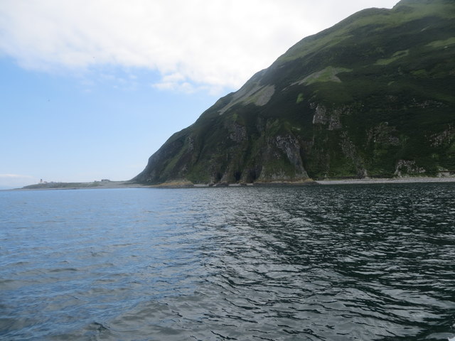
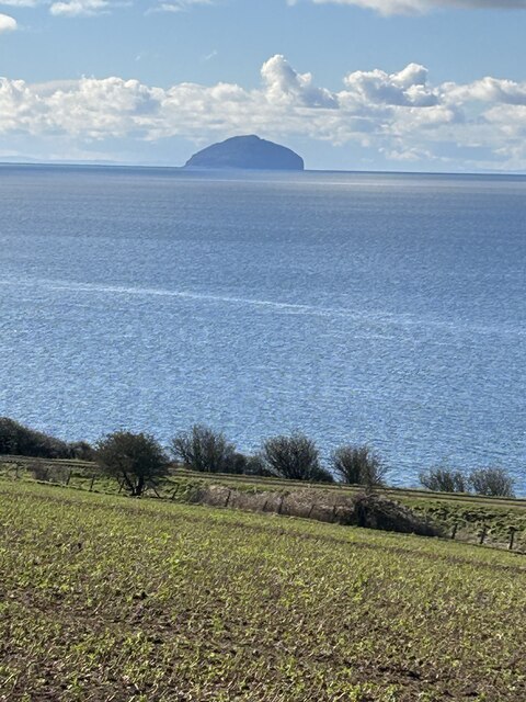
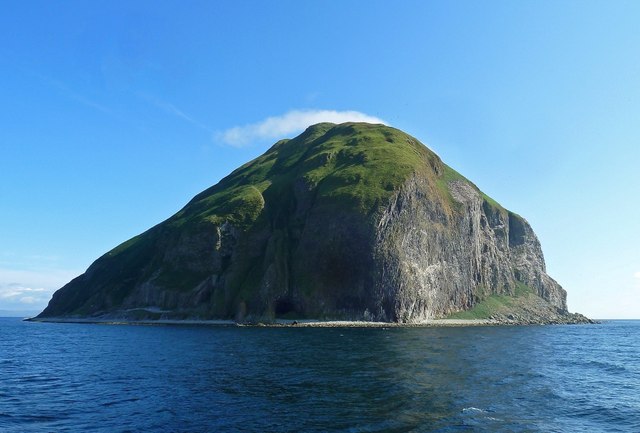
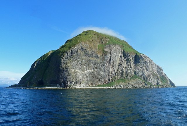
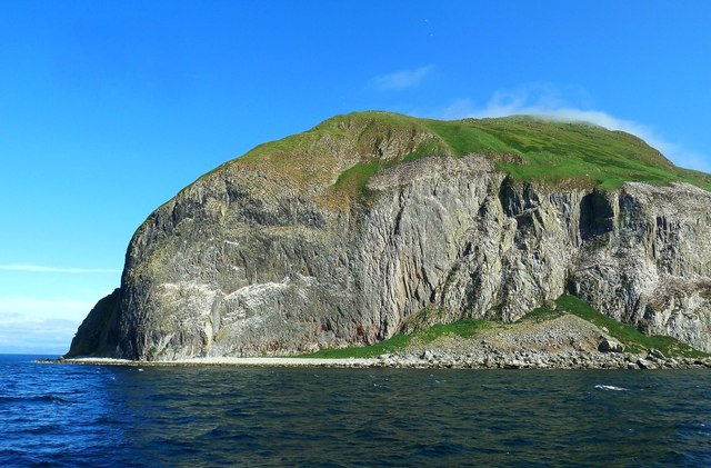
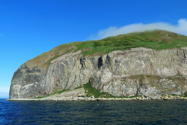
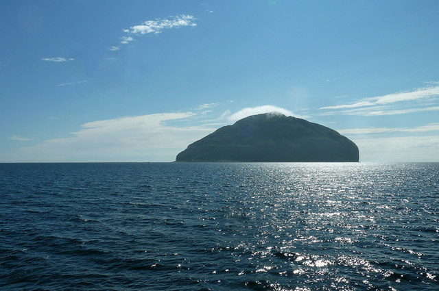
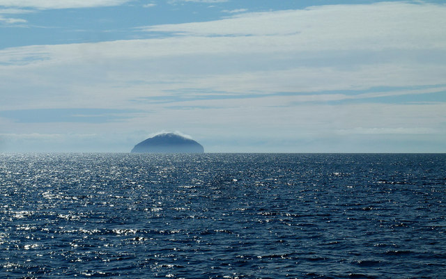
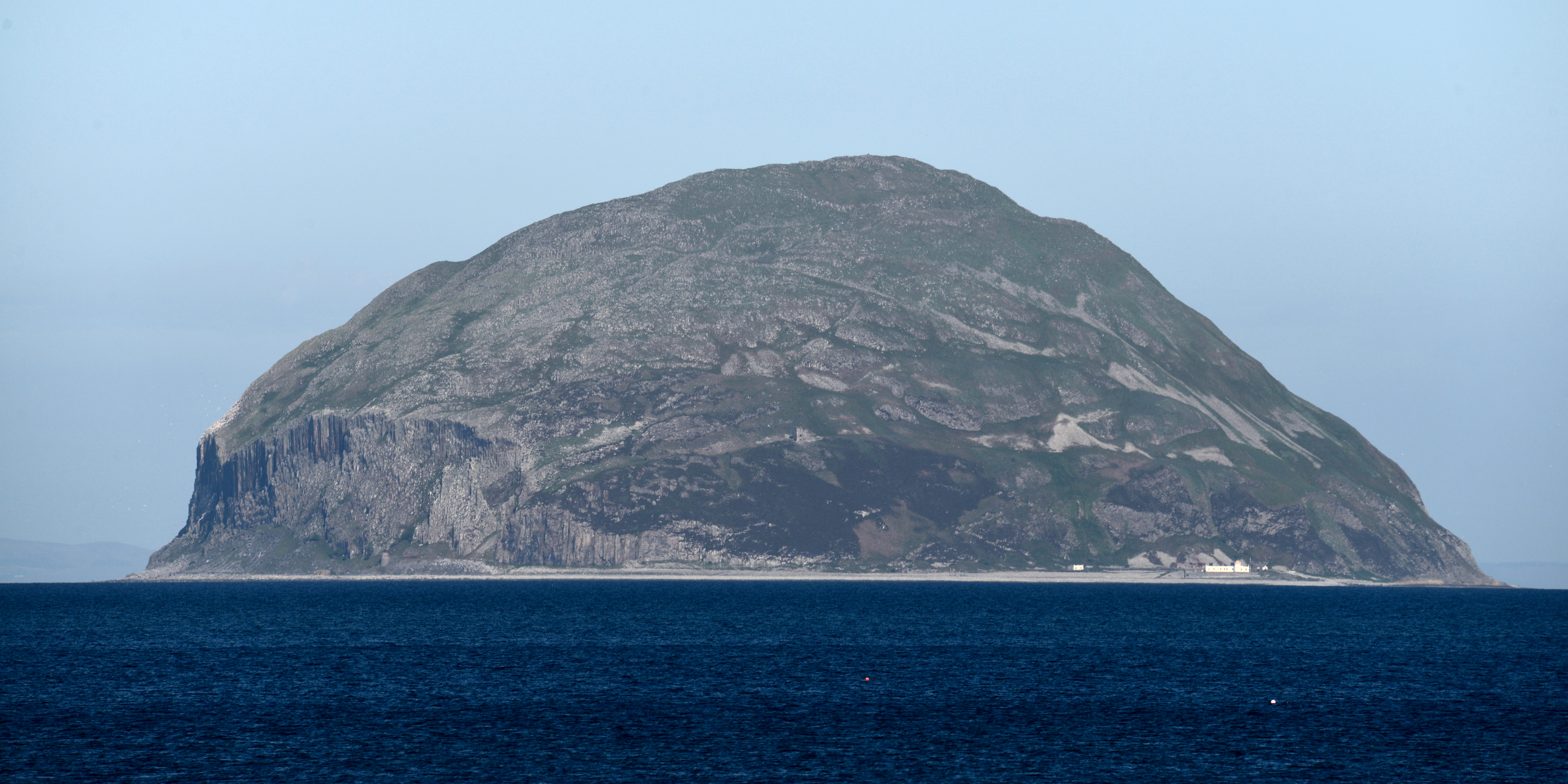
Ailsa Craig is a small, uninhabited island located off the coast of Ayrshire, Scotland. It is situated in the Firth of Clyde, approximately 16 kilometers west of Girvan. The island spans an area of around 100 hectares and rises to a height of 338 meters above sea level, making it a prominent landmark in the region.

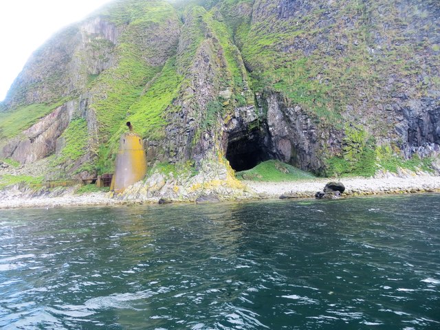
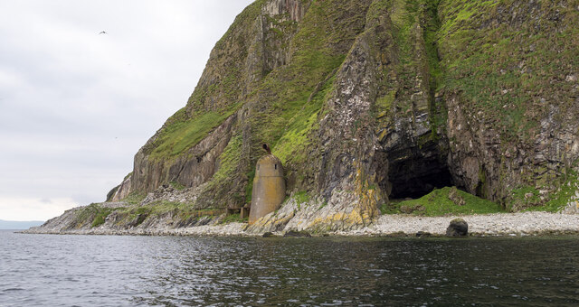
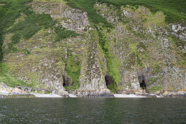
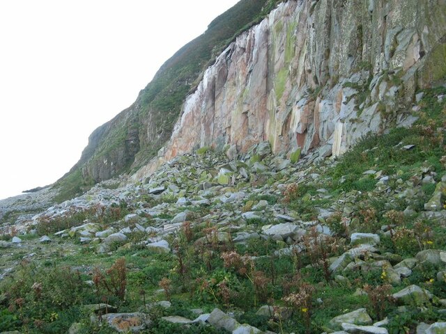
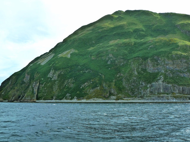
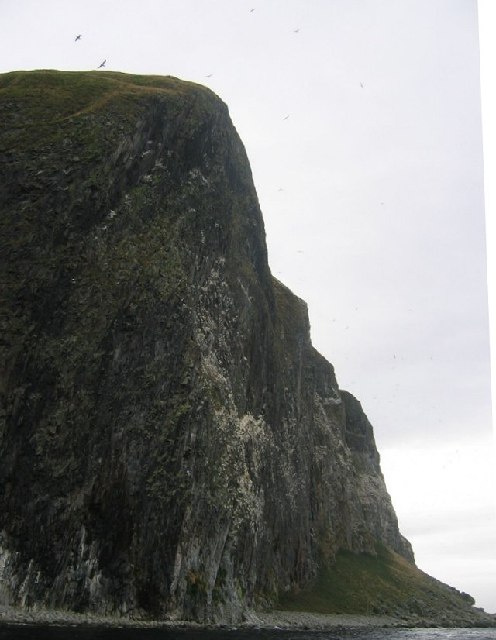
Ailsa Craig is renowned for its distinctive conical shape, which is the result of volcanic activity millions of years ago. The island is composed mainly of microgranite, a type of igneous rock that is highly sought after for its use in the production of curling stones. In fact, Ailsa Craig has been the primary source of this unique rock used in the sport of curling since the 19th century.

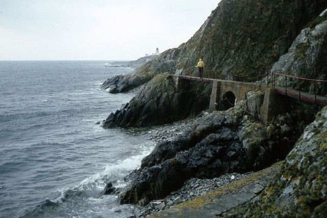
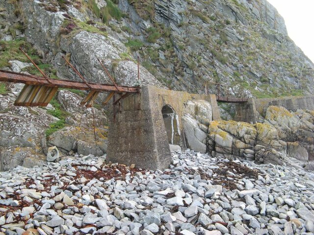
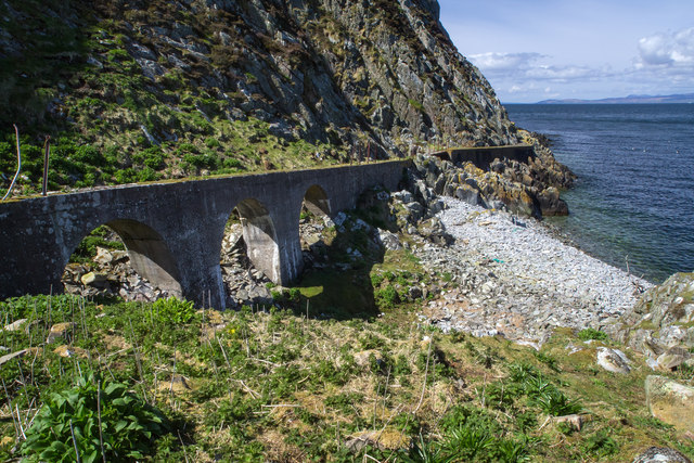
Despite being uninhabited, the island has a rich history. It was once used as a refuge for early Christian hermits and later became a sanctuary for persecuted Covenanters during the 17th century. In the 19th century, a lighthouse was constructed on the island to guide ships passing through the Firth of Clyde.

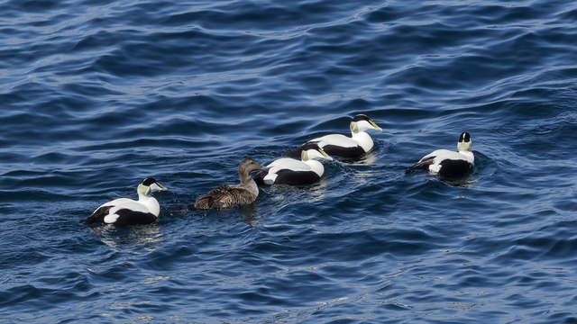
Today, Ailsa Craig is a designated bird sanctuary and is home to a wide variety of seabirds, including puffins, gannets, and guillemots. It is also a popular destination for birdwatchers and nature enthusiasts, who can visit the island by boat during the summer months. The unique geological features, historical significance, and abundant wildlife make Ailsa Craig an intriguing and picturesque destination for visitors.

If you have any feedback on the listing, please let us know in the comments section below.

Ailsa Craig Images

Images are sourced within 2km of 55.252101/-5.1156416 or Grid Reference NX0299. Thanks to Geograph Open Source API. All images are credited.

Swine cave and disused foghorn on Ailsa Craig
Swine holes below the cliffs on Ailsa Craig
Ailsa Craig - on the walkway which leads to the northern Fog Horn
Ailsa Craig The disused northern foghorn and Swine cave on the north-western side of Ailsa Craig.
Ailsa Craig
The disused northern foghorn and Swine cave on the north-western side of Ailsa Craig.
Ailsa Craig The 'Swine Holes' on the north-eastern side of the island. The raised track carried a compressed air pipeline for the nearby foghorn.
Ailsa Craig
The 'Swine Holes' on the north-eastern side of the island. The raised track carried a compressed air pipeline for the nearby foghorn.
Ailsa Craig Ailsa Craig
Ailsa Craig in the Firth of Clyde southwest of Turnberry, Ayrshire. The photo was taken from the lay-by on the A719 road between the Electric Brae and Dunure.
The island is quarried for its rare microgranite which is used to manufacture curling stones and according to Wikipedia, 'As of 2004, 60–70% of all curling stones in use were made from granite from the island.'
A disused section of the Maidens and Dunure Light Railway on the Ayrshire coast can be seen above the waterline.
Ailsa Craig
Ailsa Craig Ailsa Craig in the Firth of Clyde southwest of Turnberry, Ayrshire. The photo was taken from the lay-by on the A719 road between the Electric Brae and Dunure. The island is quarried for its rare microgranite which is used to manufacture curling stones and according to Wikipedia, 'As of 2004, 60–70% of all curling stones in use were made from granite from the island.' A disused section of the Maidens and Dunure Light Railway on the Ayrshire coast can be seen above the waterline.
Collapsed bridge The engineering of the walkway, which also carried the compressed-air pipes to the northern foghorn, is impressive. Here an iron girder span is in a dire state of corrosion and collapse, but the concrete arches are in good shape. Notable on the shore is an abandoned stone block from which a curling-stone blank has been removed by coring. A great deal of the rock on the shore is angular, and probably waste tipped from the curling-stone working.
Collapsed bridge
The engineering of the walkway, which also carried the compressed-air pipes to the northern foghorn, is impressive. Here an iron girder span is in a dire state of corrosion and collapse, but the concrete arches are in good shape. Notable on the shore is an abandoned stone block from which a curling-stone blank has been removed by coring. A great deal of the rock on the shore is angular, and probably waste tipped from the curling-stone working.
Modern extraction In 2020, Kays Curling Stones applied for permission to take new stone from the island and extended their lease on quarries until 2050 and permitted to take 25,000 tons of stone. Here is the site of extraction from 2021 which was famous for providing stones for the 2022 Beijing Olympic games. Extraction takes place during the winter so that seabirds are not disturbed, and that brings its own logistical problems on this island.
Modern extraction
In 2020, Kays Curling Stones applied for permission to take new stone from the island and extended their lease on quarries until 2050 and permitted to take 25,000 tons of stone. Here is the site of extraction from 2021 which was famous for providing stones for the 2022 Beijing Olympic games. Extraction takes place during the winter so that seabirds are not disturbed, and that brings its own logistical problems on this island.
Walkway to north foghorn Beyond this point the path to the north foghorn is unsafe according to a prominent sign, the handrail and footbridges being in disrepair.
Walkway to north foghorn
Beyond this point the path to the north foghorn is unsafe according to a prominent sign, the handrail and footbridges being in disrepair.
Eider Ducks There were several dozen of these strikingly handsome ducks swimming in groups within fifty yards of the shore. As yet, this early in the year, there were no signs of nesting.
Eider Ducks
There were several dozen of these strikingly handsome ducks swimming in groups within fifty yards of the shore. As yet, this early in the year, there were no signs of nesting.
Ailsa Craig View This view of Ailsa Craig shows the remains of the old tramway that used to transport the fine-grained micro-granite which was quarried here to make curling stones, kerbstones and cobbles. In the 15th century, the island belonged to the monastic order at Crossraguel Abbey. Apparently it was used as a place of solitary confinement for clerics who had failed in their duties.
Ailsa Craig View
This view of Ailsa Craig shows the remains of the old tramway that used to transport the fine-grained micro-granite which was quarried here to make curling stones, kerbstones and cobbles. In the 15th century, the island belonged to the monastic order at Crossraguel Abbey. Apparently it was used as a place of solitary confinement for clerics who had failed in their duties.
Goodbye Ailsa Ailsa Craig, viewed as the paddle steamer “Waverley” left for the return journey to Ayr on a particularly good late-July afternoon. Formed by intense volcanic activity about 60 million years ago, the spectacular rocky island looks different on each side, with huge columnar cliffs rising straight up from the sea. Whatever the weather, a sail around the Craig is always a memorable experience.
Goodbye Ailsa
Ailsa Craig, viewed as the paddle steamer “Waverley” left for the return journey to Ayr on a particularly good late-July afternoon. Formed by intense volcanic activity about 60 million years ago, the spectacular rocky island looks different on each side, with huge columnar cliffs rising straight up from the sea. Whatever the weather, a sail around the Craig is always a memorable experience.
Leaving Ailsa Craig Ailsa Craig with a tiny cloud cap, viewed as the paddle steamer “Waverley” left for the return journey to Ayr on a particularly good late-July afternoon. Formed by intense volcanic activity about 60 million years ago, the spectacular rocky island looks different on each side, with huge columnar cliffs rising straight up from the sea. Whatever the weather, a sail around the Craig is always a memorable experience.
Leaving Ailsa Craig
Ailsa Craig with a tiny cloud cap, viewed as the paddle steamer “Waverley” left for the return journey to Ayr on a particularly good late-July afternoon. Formed by intense volcanic activity about 60 million years ago, the spectacular rocky island looks different on each side, with huge columnar cliffs rising straight up from the sea. Whatever the weather, a sail around the Craig is always a memorable experience.
Eagle's Seat Ailsa Craig, viewed at Eagle's Seat as the paddle steamer “Waverley” left for the return journey to Ayr on a particularly good late-July afternoon. Formed by intense volcanic activity about 60 million years ago, the spectacular rocky island looks different on each side, with huge columnar cliffs rising straight up from the sea. Whatever the weather, a sail around the Craig is always a memorable experience.
Eagle's Seat
Ailsa Craig, viewed at Eagle's Seat as the paddle steamer “Waverley” left for the return journey to Ayr on a particularly good late-July afternoon. Formed by intense volcanic activity about 60 million years ago, the spectacular rocky island looks different on each side, with huge columnar cliffs rising straight up from the sea. Whatever the weather, a sail around the Craig is always a memorable experience.
Eagle's Seat View Ailsa Craig with a tiny cloud cap, viewed at Eagle's Seat as the paddle steamer “Waverley” left for the return journey to Ayr on a particularly good late-July afternoon. Formed by intense volcanic activity about 60 million years ago, the spectacular rocky island looks different on each side, with huge columnar cliffs rising straight up from the sea. Whatever the weather, a sail around the Craig is always a memorable experience.
Eagle's Seat View
Ailsa Craig with a tiny cloud cap, viewed at Eagle's Seat as the paddle steamer “Waverley” left for the return journey to Ayr on a particularly good late-July afternoon. Formed by intense volcanic activity about 60 million years ago, the spectacular rocky island looks different on each side, with huge columnar cliffs rising straight up from the sea. Whatever the weather, a sail around the Craig is always a memorable experience.
Ailsa View A distant view of Ailsa Craig taken from the passenger steamer "Waverley" on a beautiful late-July afternoon when the Craig was developing a small cloud cap. The island lies half-way between Glasgow and Belfast, giving rise to the nick-name of “Paddy’s Milestone”, a landmark for Irish immigrants heading for Scotland in the 19th century.
Ailsa View
A distant view of Ailsa Craig taken from the passenger steamer "Waverley" on a beautiful late-July afternoon when the Craig was developing a small cloud cap. The island lies half-way between Glasgow and Belfast, giving rise to the nick-name of “Paddy’s Milestone”, a landmark for Irish immigrants heading for Scotland in the 19th century.
Towards Ailsa Craig A distant Ailsa Craig, viewed from the paddle steamer “Waverley” on a particularly good late-July afternoon. Formed by intense volcanic activity about 60 million years ago, the spectacular rocky island looks different on each side, with huge columnar cliffs rising straight up from the sea. The island lies half-way between Glasgow and Belfast, giving rise to the nick-name of “Paddy’s Milestone”, a landmark for Irish immigrants heading for Scotland in the 19th century. A local weather saying claims that, if you can see Ailsa, it’s going to rain and, if you can’t see Ailsa, it’s raining already.
Towards Ailsa Craig
A distant Ailsa Craig, viewed from the paddle steamer “Waverley” on a particularly good late-July afternoon. Formed by intense volcanic activity about 60 million years ago, the spectacular rocky island looks different on each side, with huge columnar cliffs rising straight up from the sea. The island lies half-way between Glasgow and Belfast, giving rise to the nick-name of “Paddy’s Milestone”, a landmark for Irish immigrants heading for Scotland in the 19th century. A local weather saying claims that, if you can see Ailsa, it’s going to rain and, if you can’t see Ailsa, it’s raining already.
Eagle's Seat The north end of Ailsa Craig. Very steep ground, often overhanging. Anything not overhanging has a gannet on it.
Eagle's Seat
The north end of Ailsa Craig. Very steep ground, often overhanging. Anything not overhanging has a gannet on it.
Show me another place!

Ailsa Craig is located at Grid Ref: NX0299 (Lat: 55.252101, Lng: -5.1156416)

Unitary Authority: South Ayrshire

Police Authority: Ayrshire

What 3 Words

///moods.jugs.tulip. Near Girvan, South Ayrshire

Related Wikis

Ailsa Craig

Ailsa Craig (; Scots: Ailsae Craig; Scottish Gaelic: Creag Ealasaid) is an island of 99 ha (240 acres) in the outer Firth of Clyde, 16 km (8+1⁄2 nmi) west...

Ailsa Craig Lighthouse

The Ailsa Craig Lighthouse, is an active 19th century lighthouse located on Ailsa Craig, an island in the Firth of Clyde, just offshore from Girvan, South...

Nearby Amenities

Located within 500m of 55.252101,-5.1156416
Ailsa Craig
Corbett: no
Ele: 340
Graham: no
Marilyn: yes
Munro: no
Name Sco: Ailsae Craig
Natural: peak
Prominence: 340
Wikidata: Q405346
Wikipedia: en:Ailsa Craig
Lat/Long: 55.2527392/-5.118173
Man Made: pier
Source: os7
Lat/Long: 55.2534409/-5.1101529
Abandoned: yes
Man Made: lighthouse
Seamark Light 1 Character: Fl
Seamark Light 1 Colour: white
Seamark Light 1 Height: 18
Seamark Light 1 Period: 4
Seamark Light 1 Range: 17
Seamark Light 1 Sector End: 28
Seamark Light 1 Sector Start: 145
Seamark Light 1 Sequence: 0.3+(3.7)
Seamark Light Reference: A 4582
Seamark Name: Ailsa Craig
Seamark Type: light_major
Wikidata: Q4697091
Wikipedia: en:Ailsa Craig Lighthouse
Lat/Long: 55.2519047/-5.1084378
Man Made: survey_point
Lat/Long: 55.2527182/-5.1182771
The data included in this document is from www.openstreetmap.org. The data is made available under ODbL.

Have you been to Ailsa Craig?

Leave your review of Ailsa Craig below (or comments, questions and feedback).