Biggal

Island in Cornwall

England

Biggal

Pillbox entrance On Tolman Point.
Pillbox entrance Credit: David Lally

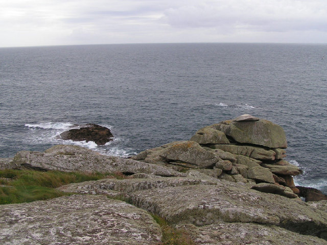
Biggal is a picturesque island located off the coast of Cornwall, England. With a land area of approximately 1.5 square miles, it is one of the smaller islands in the region. Biggal is surrounded by the Atlantic Ocean, providing stunning views and a tranquil atmosphere for visitors.

The island is known for its rugged coastline, with towering cliffs and hidden coves that attract nature lovers and adventure enthusiasts. Its diverse landscape offers a range of outdoor activities, including hiking, rock climbing, and bird watching. The island is also home to several rare bird species, making it a popular destination for ornithologists.

Despite its small size, Biggal boasts a close-knit community of around 200 residents. The island has a charming village with traditional cottages and a quaint harbor, where local fishermen bring in their daily catch. The village also features a few shops, restaurants, and accommodation options for tourists.

Transportation to Biggal is primarily by boat, with ferry services operating from nearby coastal towns. The island's isolation adds to its appeal, as it provides a peaceful retreat away from the hustle and bustle of mainland life.

Visitors to Biggal can immerse themselves in the island's rich history by exploring the ancient ruins and archaeological sites scattered throughout. The island has a unique cultural heritage, with influences from both Celtic and Roman civilizations.

Overall, Biggal offers an idyllic escape for nature lovers and those seeking tranquility in a stunning coastal setting. Its natural beauty, friendly community, and rich history make it a hidden gem in the Cornish Isles.

If you have any feedback on the listing, please let us know in the comments section below.

Biggal Images

Images are sourced within 2km of 49.906114/-6.3153566 or Grid Reference SV9009. Thanks to Geograph Open Source API. All images are credited.

Pillbox entrance On Tolman Point.
Pillbox entrance
On Tolman Point.
A fork in the path Compare with <a href="https://www.geograph.org.uk/photo/821812">SV8908 : A Fork in the Path</a> taken by me one day short of fifteen years ago.
A fork in the path
Compare with SV8908 : A Fork in the Path taken by me one day short of fifteen years ago.
Sunrise over Gugh
Sunrise over Gugh
Sunrise over Penninis Glad I decided to walk this way this morning.
Sunrise over Penninis
Glad I decided to walk this way this morning.
Dropnose just before sunrise
Tresco will be busy today Three cruise ships in The Road today.  No doubt the most popular shore trip will be to Tesco's famous sub-tropical gardens.  As long as they keep away from St Agnes, that will be fine.

The boat heading into Perconger is the St Agnes boating's sea taxi craft "Enterprise".
Tresco will be busy today
Three cruise ships in The Road today. No doubt the most popular shore trip will be to Tesco's famous sub-tropical gardens. As long as they keep away from St Agnes, that will be fine. The boat heading into Perconger is the St Agnes boating's sea taxi craft "Enterprise".
Rock formations at Peninnis Head
Morning Point, the Garrison Looking SE to the offshore rocks Wras and (behind and smaller) Biggal; Inner Head <a href="https://www.geograph.org.uk/gridref/SV908093">SV908093</a> (part of Peninnis Head) is just visible to the far left, on the other side of Porth Cressa bay. Note the passing storm on the horizon...
Morning Point, the Garrison
Looking SE to the offshore rocks Wras and (behind and smaller) Biggal; Inner Head SV908093 (part of Peninnis Head) is just visible to the far left, on the other side of Porth Cressa bay. Note the passing storm on the horizon...
Peninnis Head Looking SSE to the lighthouse from approx. SV910097.
Peninnis Head
Looking SSE to the lighthouse from approx. SV910097.
Old Town Bay from Peninnis There is a former Battery on the island to the right of the pine tree.
Old Town Bay from Peninnis
There is a former Battery on the island to the right of the pine tree.
Tolman Point Viewed from the north on the very edge of the square; note the WW2 pillbox.
Tolman Point
Viewed from the north on the very edge of the square; note the WW2 pillbox.
Church Point The end of Church Point (just below the end of the main runway of St Mary's Airport) looking out to sea; this (and a rock off the end of Giant's Castle) is the only land in the square.
Church Point
The end of Church Point (just below the end of the main runway of St Mary's Airport) looking out to sea; this (and a rock off the end of Giant's Castle) is the only land in the square.
Lighthouse at Peninnis Head, St. Mary's The lighthouse guides shipping passing through St. Mary's Sound, between the islands of Agnes and St. Mary's.  The lattice-work construction reduces its wind resistance.
Lighthouse at Peninnis Head, St. Mary's
The lighthouse guides shipping passing through St. Mary's Sound, between the islands of Agnes and St. Mary's. The lattice-work construction reduces its wind resistance.
St. Mary’s: Peninnis Point Viewed from the ferry from Penzance shortly before arrival on the island.
St. Mary’s: Peninnis Point
Viewed from the ferry from Penzance shortly before arrival on the island.
Photographing the Rock Labyrinth The area between the lighthouse and the Outer Head is appropriately known as the Rock Labyrinth. In younger (and slimmer) days we would explore this fantastic maze of huge granite rocks.
Photographing the Rock Labyrinth
The area between the lighthouse and the Outer Head is appropriately known as the Rock Labyrinth. In younger (and slimmer) days we would explore this fantastic maze of huge granite rocks.
Carn Leh, St. Mary's, Scilly Isles
Footpath on Peninnis Head, St. Mary's, Scilly Isles
Granite Stone Walls Granite is pretty much the only rock there is on the Scillies and there's plenty of it, so it makes sense to build your field walls out of it.
Granite Stone Walls
Granite is pretty much the only rock there is on the Scillies and there's plenty of it, so it makes sense to build your field walls out of it.
Show me another place!

Biggal is located at Grid Ref: SV9009 (Lat: 49.906114, Lng: -6.3153566)

Division: Isles of Scilly

Unitary Authority: Isles of Scilly

Police Authority: Devon and Cornwall

What 3 Words

///irrigated.action.stalemate. Near St Mary's, Isles of Scilly

Related Wikis

Minnehaha (cargo ship)

The Minnehaha was a barque built in 1857 and wrecked on 18 January 1874 in the Isles of Scilly. == Wreck == On 18 January 1874, while travelling from...

Peninnis Lighthouse

Peninnis Lighthouse is situated on Peninnis Head, St Mary's, Isles of Scilly. == History == The light was built to replace the lighthouse in the centre...

Garrison Tower

Garrison Tower is a Grade II listed structure on St Mary's, Isles of Scilly The tower was built in the 17th century as a windmill. By 1750 it was abandoned...

Buzza Tower

Buzza Tower is a Grade II listed structure on St Mary's, Isles of Scilly now used as a camera obscura. The tower was built in 1821 as a windmill. It was...

Nearby Amenities

Located within 500m of 49.906114,-6.3153566
Barrier: stile
Lat/Long: 49.9091148/-6.3189834
Morning Point Battery
Historic: fort
Lat/Long: 49.9089138/-6.3183708
The data included in this document is from www.openstreetmap.org. The data is made available under ODbL.

Have you been to Biggal?

Leave your review of Biggal below (or comments, questions and feedback).