The Chair

Island in Cornwall

England

The Chair

Church Point
Church Point Credit: David Lally

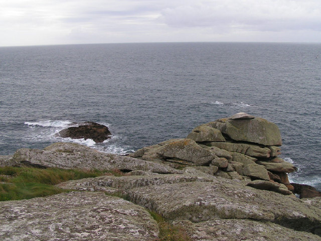
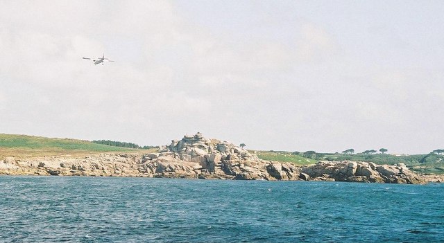
The Chair is a small island located off the coast of Cornwall, England. Situated in the Celtic Sea, it is part of the Isles of Scilly archipelago. The island gets its name from a rock formation that resembles a chair when viewed from a certain angle.

Covering an area of approximately 2 hectares (5 acres), The Chair is a designated Site of Special Scientific Interest due to its unique flora and fauna. The island is predominantly rocky, with rugged cliffs rising up to 30 meters (98 feet) in some places. It is home to a diverse range of seabirds, including puffins, razorbills, and guillemots, which nest on the cliffs during breeding season.

Access to The Chair is restricted due to its protected status, and visitors are not allowed to land on the island. However, it can be observed from nearby boats or from the coastal path on the mainland. The island is particularly popular with birdwatchers and nature enthusiasts who flock to the area to witness the impressive bird colonies and enjoy the scenic views.

The Chair is part of the larger Isles of Scilly Area of Outstanding Natural Beauty, known for its unspoiled landscapes and crystal-clear waters. The island's isolation and rugged beauty make it a must-visit destination for those seeking tranquility and a close connection with nature.

If you have any feedback on the listing, please let us know in the comments section below.

The Chair Images

Images are sourced within 2km of 49.90507/-6.3071547 or Grid Reference SV9009. Thanks to Geograph Open Source API. All images are credited.

Church Point
Church Point
Pillbox entrance On Tolman Point.
Pillbox entrance
On Tolman Point.
Sunrise over Penninis Glad I decided to walk this way this morning.
Sunrise over Penninis
Glad I decided to walk this way this morning.
Dropnose just before sunrise
Rock formations at Peninnis Head
Near Spanish Ledges - Scillies There's lots of yachts like this to be found in Scilly waters.
Near Spanish Ledges - Scillies
There's lots of yachts like this to be found in Scilly waters.
Morning Point, the Garrison Looking SE to the offshore rocks Wras and (behind and smaller) Biggal; Inner Head <a href="https://www.geograph.org.uk/gridref/SV908093">SV908093</a> (part of Peninnis Head) is just visible to the far left, on the other side of Porth Cressa bay. Note the passing storm on the horizon...
Morning Point, the Garrison
Looking SE to the offshore rocks Wras and (behind and smaller) Biggal; Inner Head SV908093 (part of Peninnis Head) is just visible to the far left, on the other side of Porth Cressa bay. Note the passing storm on the horizon...
Peninnis Head Looking SSE to the lighthouse from approx. SV910097.
Peninnis Head
Looking SSE to the lighthouse from approx. SV910097.
Old Town Bay from Peninnis There is a former Battery on the island to the right of the pine tree.
Old Town Bay from Peninnis
There is a former Battery on the island to the right of the pine tree.
Tolman Point Viewed from the north on the very edge of the square; note the WW2 pillbox.
Tolman Point
Viewed from the north on the very edge of the square; note the WW2 pillbox.
Church Point The end of Church Point (just below the end of the main runway of St Mary's Airport) looking out to sea; this (and a rock off the end of Giant's Castle) is the only land in the square.
Church Point
The end of Church Point (just below the end of the main runway of St Mary's Airport) looking out to sea; this (and a rock off the end of Giant's Castle) is the only land in the square.
Lighthouse at Peninnis Head, St. Mary's The lighthouse guides shipping passing through St. Mary's Sound, between the islands of Agnes and St. Mary's.  The lattice-work construction reduces its wind resistance.
Lighthouse at Peninnis Head, St. Mary's
The lighthouse guides shipping passing through St. Mary's Sound, between the islands of Agnes and St. Mary's. The lattice-work construction reduces its wind resistance.
St. Mary’s: Peninnis Point Viewed from the ferry from Penzance shortly before arrival on the island.
St. Mary’s: Peninnis Point
Viewed from the ferry from Penzance shortly before arrival on the island.
St. Mary’s: plane over Church Point A plane approaches Scilly's airport, viewed from the ferry from Penzance.
St. Mary’s: plane over Church Point
A plane approaches Scilly's airport, viewed from the ferry from Penzance.
Photographing the Rock Labyrinth The area between the lighthouse and the Outer Head is appropriately known as the Rock Labyrinth. In younger (and slimmer) days we would explore this fantastic maze of huge granite rocks.
Photographing the Rock Labyrinth
The area between the lighthouse and the Outer Head is appropriately known as the Rock Labyrinth. In younger (and slimmer) days we would explore this fantastic maze of huge granite rocks.
Carn Leh, St. Mary's, Scilly Isles
Footpath on Peninnis Head, St. Mary's, Scilly Isles
Granite Stone Walls Granite is pretty much the only rock there is on the Scillies and there's plenty of it, so it makes sense to build your field walls out of it.
Granite Stone Walls
Granite is pretty much the only rock there is on the Scillies and there's plenty of it, so it makes sense to build your field walls out of it.
Show me another place!

The Chair is located at Grid Ref: SV9009 (Lat: 49.90507, Lng: -6.3071547)

Division: Isles of Scilly

Unitary Authority: Isles of Scilly

Police Authority: Devon and Cornwall

What 3 Words

///chair.paves.unstated. Near St Mary's, Isles of Scilly

Related Wikis

Minnehaha (cargo ship)

The Minnehaha was a barque built in 1857 and wrecked on 18 January 1874 in the Isles of Scilly. == Wreck == On 18 January 1874, while travelling from...

Peninnis Lighthouse

Peninnis Lighthouse is situated on Peninnis Head, St Mary's, Isles of Scilly. == History == The light was built to replace the lighthouse in the centre...

Peninnis Head

Peninnis Head (Cornish: Penn Enys, meaning Island Head) is the southernmost point of St Mary's, Isles of Scilly. The headland is within the Isles of Scilly...

St Mary's Old Church, St Mary's

St Mary's Old Church, St Mary's is a parish church in the Church of England located in Old Town on St Mary's, Isles of Scilly, Cornwall, United Kingdom...

Nearby Amenities

Located within 500m of 49.90507,-6.3071547
Source: PGS
Lat/Long: 49.9082393/-6.3026466
Barrier: stile
Lat/Long: 49.9087421/-6.3080648
Barrier: stile
Lat/Long: 49.9077202/-6.3026952
Pulpit Rock
Tourism: viewpoint
Lat/Long: 49.9060217/-6.3007404
Peninnis Head
Place: locality
Wikidata: Q7162906
Wikipedia: en:Peninnis Head
Lat/Long: 49.9069564/-6.3039993
Historic: ruins
Man Made: windmill
Lat/Long: 49.9080784/-6.3051167
Stony Porth
Natural: bay
Source: OS Open Names
Lat/Long: 49.9083693/-6.3092985
The data included in this document is from www.openstreetmap.org. The data is made available under ODbL.

Have you been to The Chair?

Leave your review of The Chair below (or comments, questions and feedback).