Great End

Hill, Mountain in Cumberland Allerdale

England

Great End

Scafell Pike (behind) and Scafell from Over Beck
Scafell Pike (behind) and Scafell from Over Beck Credit: Johnny Coop

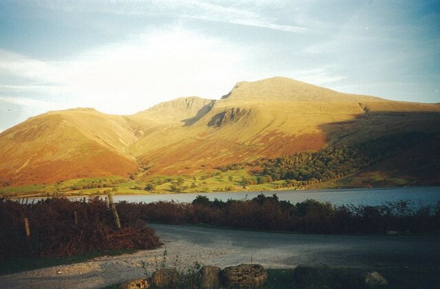
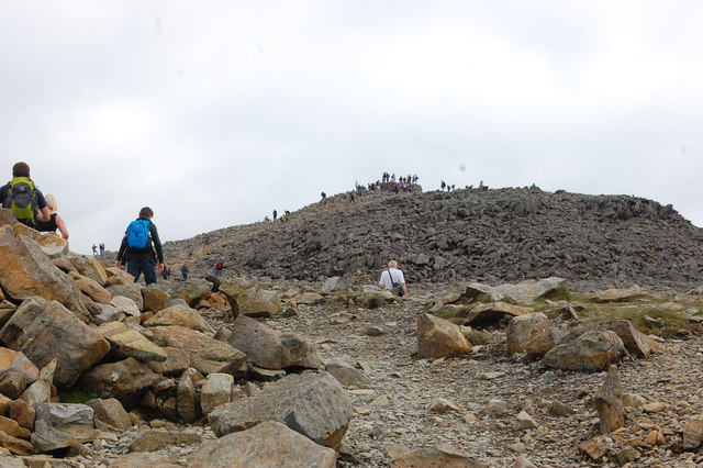
Great End is a prominent hill/mountain located in the Lake District National Park, in the county of Cumbria, England. Standing at an impressive height of 910 meters (2,986 feet), it is one of the highest peaks in the region. Great End is part of the Scafell Pike massif, which includes some of the most iconic and challenging mountains in England.

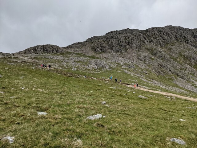
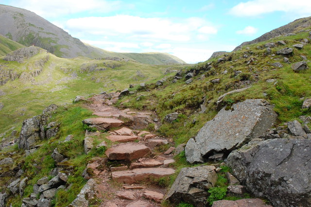
The name "Great End" aptly describes the steep and rugged nature of this peak. Its sheer cliffs and crags make it a popular destination for experienced hikers and climbers seeking a thrilling adventure. The ascent to the summit is demanding, requiring a reasonable level of fitness and experience in mountaineering.

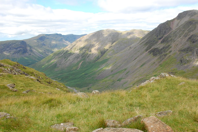
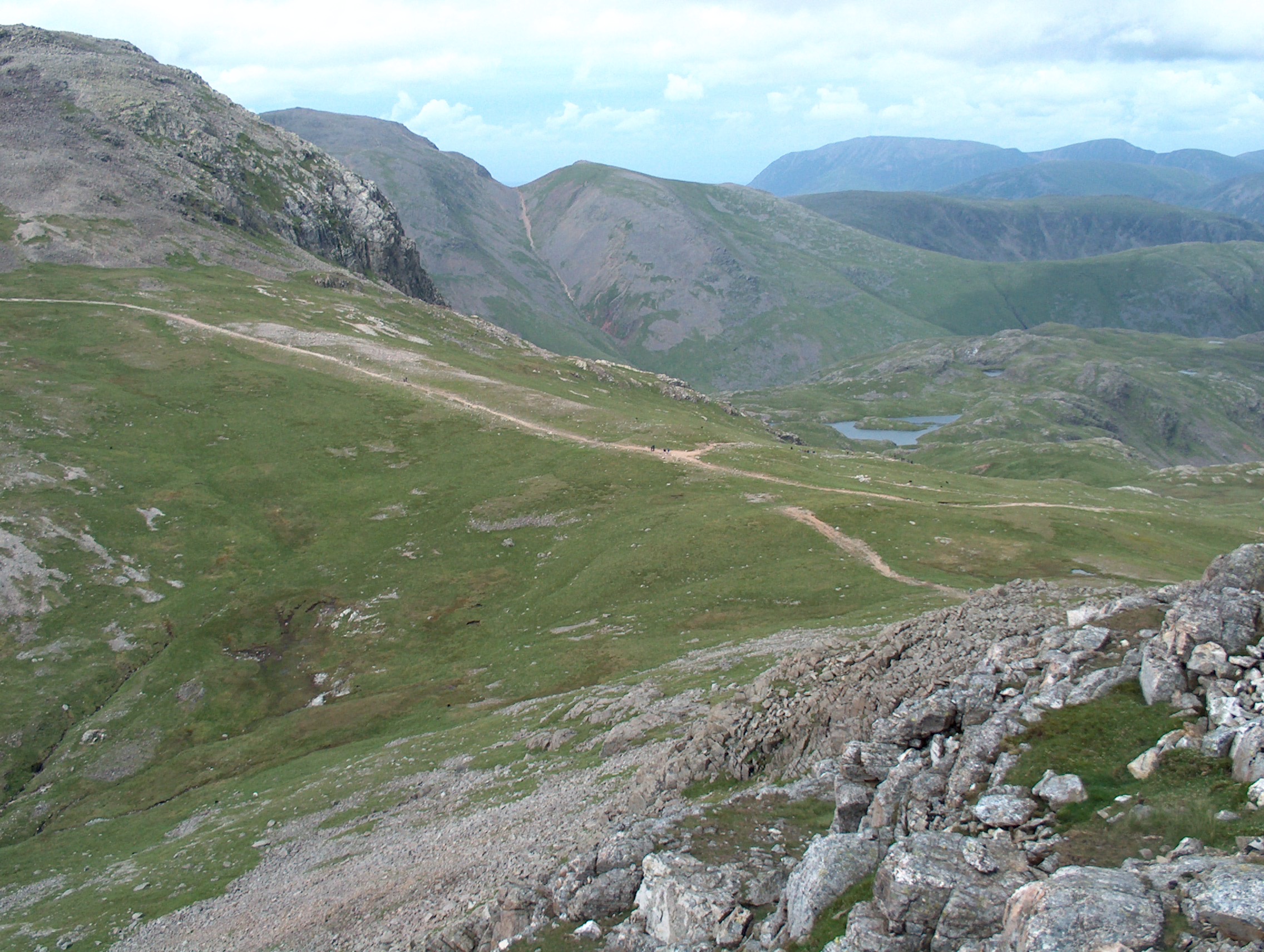
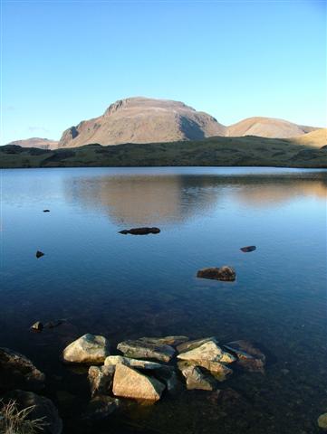
From the top of Great End, visitors are rewarded with breathtaking panoramic views of the surrounding landscape. On clear days, one can see the nearby peaks of Scafell Pike and Ill Crag, as well as the beautiful valleys and lakes that dot the region. The view stretches as far as the eye can see, offering a sense of awe and tranquility.

Great End is also a pivotal point for several hiking routes, including the popular Corridor Route and the challenging Esk Hause route. Many hikers choose to include Great End in their journey to conquer the highest peak in England, Scafell Pike. It is worth noting that due to its exposed nature and unpredictable weather conditions, caution is essential when attempting to summit Great End. Proper equipment, navigation skills, and knowledge of the terrain are crucial for a safe and enjoyable experience.

If you have any feedback on the listing, please let us know in the comments section below.
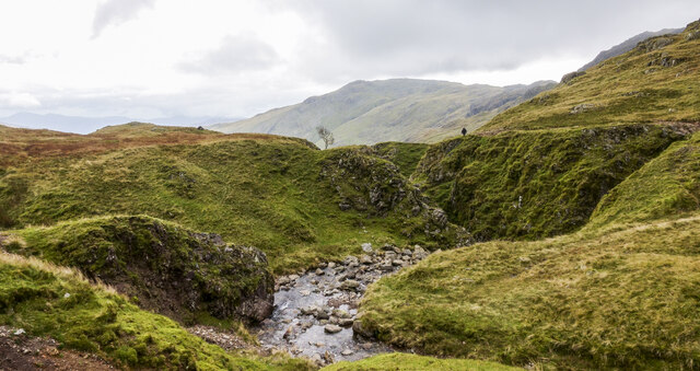
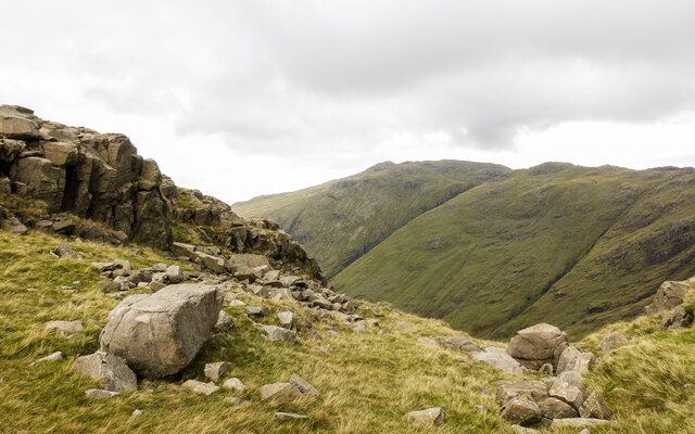
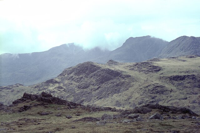
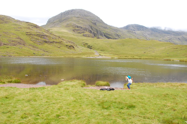
Great End Images

Images are sourced within 2km of 54.464907/-3.1945687 or Grid Reference NY2208. Thanks to Geograph Open Source API. All images are credited.

Scafell Pike (behind) and Scafell from Over Beck
Looking towards Pikes Crag
Borrowdale from Ruddy Gill Looking down the valley from alongside Ruddy Gill. Derwent Water is just visible in the distance.
Borrowdale from Ruddy Gill
Looking down the valley from alongside Ruddy Gill. Derwent Water is just visible in the distance.
Styhead Tarn
Styhead Tarn
Styhead Tarn
Styhead Tarn
Ruddy Gill Ruddy Gill about to enter its gorge which is on the eastern side of Sprinkling Tarn. To the right slopes rise towards Allen Crags, Glaramara is distant at the centre.
Ruddy Gill
Ruddy Gill about to enter its gorge which is on the eastern side of Sprinkling Tarn. To the right slopes rise towards Allen Crags, Glaramara is distant at the centre.
Boulders and rock outcrops on Seathwaite Fell There are many minor outcrops on Seathwaite Fell, topping its knolls and projecting from slopes. The outcrop in the image overlooks the valley of Ruddy Gill / Grains Gill, beyond which is Glaramara.
Boulders and rock outcrops on Seathwaite Fell
There are many minor outcrops on Seathwaite Fell, topping its knolls and projecting from slopes. The outcrop in the image overlooks the valley of Ruddy Gill / Grains Gill, beyond which is Glaramara.
The Scafell range from Bow Fell The grassy hill in the middle distance is Pike de Bield. On the skyline are Sca Fell (in cloud), the gap at Mickledore, and Scafell Pike (clear), with Ill Crag on the right.
The Scafell range from Bow Fell
The grassy hill in the middle distance is Pike de Bield. On the skyline are Sca Fell (in cloud), the gap at Mickledore, and Scafell Pike (clear), with Ill Crag on the right.
Styhead Tarn A stone is about to join the fishes. Great End is seen beyond the tarn but the rest of the Scafell Pike ridge is shrouded in low cloud.
Styhead Tarn
A stone is about to join the fishes. Great End is seen beyond the tarn but the rest of the Scafell Pike ridge is shrouded in low cloud.
On the Corridor Route Looking back towards Sty Head with the slopes of Green Gable beyond.
On the Corridor Route
Looking back towards Sty Head with the slopes of Green Gable beyond.
Sty Head from the Breast Route Looking back down on Sty Head while ascending Great Gable by the Breast Route. The path to Sprinkling Tarn is ahead centre.
Sty Head from the Breast Route
Looking back down on Sty Head while ascending Great Gable by the Breast Route. The path to Sprinkling Tarn is ahead centre.
View into Wasdale From the Corridor Route to Scafell Pike, looking down into upper Wasdale with Great Gable to the right.
View into Wasdale
From the Corridor Route to Scafell Pike, looking down into upper Wasdale with Great Gable to the right.
Scafell Pike Approaching the summit having climbed by the Corridor Route via Lingmell Col. Across the boulder field the summit is ahead.
Scafell Pike
Approaching the summit having climbed by the Corridor Route via Lingmell Col. Across the boulder field the summit is ahead.
Crossing scree on Bursting Knott The Moses' Trod path climbs steadily up the southern flank of Great Gable towards Styhead Pass, here crossing a substantial scree slope.
Crossing scree on Bursting Knott
The Moses' Trod path climbs steadily up the southern flank of Great Gable towards Styhead Pass, here crossing a substantial scree slope.
On Toad How The Moses' Trod path crosses another scree patch above Toad How, on the southern side of Great Gable. Ahead, the crags of Spout Head are split by the deep Skew Gill.
On Toad How
The Moses' Trod path crosses another scree patch above Toad How, on the southern side of Great Gable. Ahead, the crags of Spout Head are split by the deep Skew Gill.
Is that an otter in Styhead Tarn? Nope - it's just Daft Dog out for a bit of wild swimming.
Is that an otter in Styhead Tarn?
Nope - it's just Daft Dog out for a bit of wild swimming.
Styhead Tarn and the bridleway to Borrowdale
A small sheepfold The rather dilapidated remains of a one-time larger sheepfold.
A small sheepfold
The rather dilapidated remains of a one-time larger sheepfold.
Show me another place!

Great End is located at Grid Ref: NY2208 (Lat: 54.464907, Lng: -3.1945687)

Administrative County: Cumbria

District: Allerdale

Police Authority: Cumbria

What 3 Words

///redefined.unable.grudging. Near Ambleside, Cumbria

Related Wikis

Great End

Great End is the most northerly mountain in the Scafell chain, in the English Lake District. From the south it is simply a lump continuing this chain....

Esk Hause

Esk Hause is a mountain pass in the English Lake District, England. It is where the paths from Eskdale, Borrowdale, Langdale and Wasdale all meet. Esk...
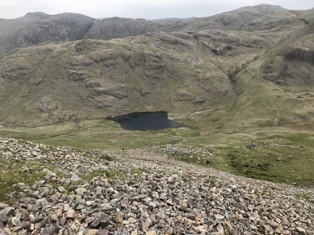
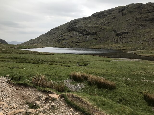
Sprinkling Tarn

Sprinkling Tarn is a body of water at the foot of Great End, in the Southern Fells in Lake District, 3 kilometres (1.9 mi) from Seathwaite, Cumbria, England...

Allen Crags

Allen Crags is a fell in the English Lake District, it lies in a group of very popular hills and is regarded as part of the Scafell group of fells. It...

Sty Head

Sty Head is a mountain pass in the English Lake District, in the county of Cumbria. It is at an altitude of 1,600 feet (488 m) and there is a small tarn...

Ill Crag

Ill Crag is a fell in the English Lake District. At 935 metres (3,068 ft), it is the fourth-highest peak in England, after Scafell Pike, Sca Fell, and...

Broad Crag

Broad Crag is a fell in the English Lake District. It is the fifth-highest peak in England at a height of 3,064 feet (934 metres). The mountain was gifted...

Esk Pike

Esk Pike is a fell in the English Lake District, one of the cirque of hills forming the head of Eskdale. == Topography == The Southern Fells include the...

Related Videos

Hiking the Bob Graham Round - Day 1

The Bob Graham Round is a circular route that starts and finishes in Keswick, Cumbria, UK - with 8160m of ascent over 99km and ...

Dangerous? Scafell Pike from Wasdale via Mickledore Wainwright Guided Walk Lake District 4K

The walk up Scafell Pike via Mickledore is an alternative route up Scafell Pike from Wasdale, sharing the initial climb with the ...

A Simple Guide to Scafell Pike | Hiking, Camping, Itinerary | Filipino UK Travel

A Simple Guide to Scafell Pike | Hiking, Camping, Itinerary | Filipino UK Travel Hello and welcome to Life Adventure Philippines!

Hiking & Wild Camping on Scafell Pike

Hiking & Wild Camping on Scafell Pike. In May 2023 I visited the Lake District to hike to the top of England's highest mountain, ...

Nearby Amenities

Located within 500m of 54.464907,-3.1945687
Ford: yes
Lat/Long: 54.4687006/-3.1913213
Long Pike
Ele: 825
Natural: peak
Lat/Long: 54.4633424/-3.1994276
Calf Cove
Place: locality
Lat/Long: 54.4627645/-3.1935233
Great End
Ele: 910
Natural: peak
Source: npe
Wikidata: Q1544269
Wikipedia: en:Great End
Lat/Long: 54.4649532/-3.194489
Ford: yes
Lat/Long: 54.4676848/-3.1902248
Ford: yes
Lat/Long: 54.4618521/-3.1923994
Central Gully
Place: locality
Lat/Long: 54.4660505/-3.1939012
Custs Gully
Place: locality
Lat/Long: 54.4669649/-3.1959382
The data included in this document is from www.openstreetmap.org. The data is made available under ODbL.

Have you been to Great End?

Leave your review of Great End below (or comments, questions and feedback).