Crowberry Hill

Hill, Mountain in Cumberland Copeland

England

Crowberry Hill

Wormshell How
Wormshell How Credit: Mick Garratt

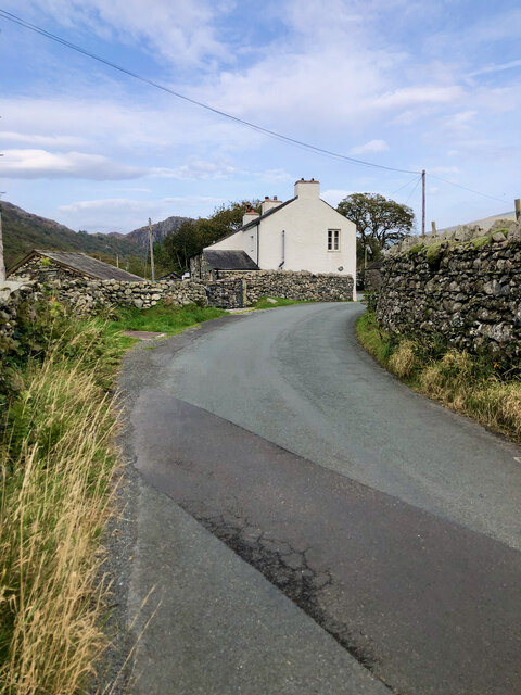
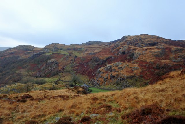
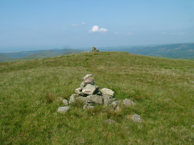
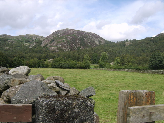
Crowberry Hill is a prominent geographical feature located in Cumberland, a county in northwest England. It is classified as both a hill and a mountain, with an elevation of approximately 2,030 feet (619 meters) above sea level. Situated within the Lake District National Park, Crowberry Hill offers breathtaking views of the surrounding landscape.

The hill is primarily composed of volcanic rocks, including basalt and andesite, which were formed during ancient volcanic activity in the region. This geological composition contributes to the hill's distinctive appearance and rugged terrain.

Crowberry Hill is a popular destination for outdoor enthusiasts, attracting hikers, climbers, and nature lovers. Several well-marked trails traverse the hill, providing opportunities for both leisurely walks and challenging hikes. The ascent to the summit is moderately demanding, but the reward is a panoramic view of the picturesque Lake District, including nearby mountains and valleys.

The hill is named after the crowberry plant (Empetrum nigrum), a hardy shrub that grows abundantly in the area. The plant is known for its dark purple berries, which are a significant food source for wildlife in the region.

Due to its elevation and exposed location, Crowberry Hill experiences changeable weather conditions throughout the year. It is advisable for visitors to come prepared with appropriate clothing and equipment, as the hill can be subject to strong winds and sudden temperature drops.

Overall, Crowberry Hill offers a memorable outdoor experience for those seeking adventure and natural beauty in the heart of Cumberland.

If you have any feedback on the listing, please let us know in the comments section below.

Crowberry Hill Images

Images are sourced within 2km of 54.352555/-3.2194485 or Grid Reference SD2095. Thanks to Geograph Open Source API. All images are credited.

Wormshell How
Wormshell How
Vernacular farm building at Hall Dunnerdale
Vernacular farm building at The Crook
Site of Commonwood Quarries For more information see Heritagegateway.org.uk <<span class="nowrap"><a title="https://www.heritagegateway.org.uk/Gateway/Results_Single.aspx?resourceID=801&uid=2887969" rel="nofollow ugc noopener" href="https://www.heritagegateway.org.uk/Gateway/Results_Single.aspx?resourceID=801&uid=2887969">Link</a><img style="margin-left:2px;" alt="External link" title="External link - shift click to open in new window" src="https://s1.geograph.org.uk/img/external.png" width="10" height="10"/></span> > [accessed 14 October 2023]

‌
Site of Commonwood Quarries
For more information see Heritagegateway.org.uk <LinkExternal link > [accessed 14 October 2023] ‌
Tales of a Tarmac Lane—Barn, Bend, and Blue Pipe A glimpse down a paved path leading to a leftward bend, featuring a stone barn sporting a slate roof, with its barn entrance sealed shut by corrugated steel. A conspicuous coil of blue water pipe leans nonchalently against the barn&amp;#039;s side wall.
Tales of a Tarmac Lane—Barn, Bend, and Blue Pipe
A glimpse down a paved path leading to a leftward bend, featuring a stone barn sporting a slate roof, with its barn entrance sealed shut by corrugated steel. A conspicuous coil of blue water pipe leans nonchalently against the barn's side wall.
Flanked by dry stone walls, a lane bearing the scar of road works
Confluence of Tarn Beck with the River Duddon
Footbridge over the River Duddon There are stepping stones a short distance downstream (to the right), but nobody in their right minds would risk them when this bridge, constructed in 1934, is available. The stones are large and often sloping, and a slip could easily result in a broken ankle, or worse.

For the acknowledgement to the bridge builder, see &lt;a href=&quot;https://www.geograph.org.uk/photo/4699873&quot;&gt;SD2296 : River Duddon footbridge plaque&lt;/a&gt;.
Footbridge over the River Duddon
There are stepping stones a short distance downstream (to the right), but nobody in their right minds would risk them when this bridge, constructed in 1934, is available. The stones are large and often sloping, and a slip could easily result in a broken ankle, or worse. For the acknowledgement to the bridge builder, see SD2296 : River Duddon footbridge plaque.
River Duddon footbridge plaque The plaque on the bridge seen in &lt;a href=&quot;https://www.geograph.org.uk/photo/4699863&quot;&gt;SD2296 : Footbridge over the River Duddon&lt;/a&gt; and &lt;a href=&quot;https://www.geograph.org.uk/photo/3796711&quot;&gt;SD2296 : Stone footbridge over River Duddon&lt;/a&gt;. 

If anyone can tell me who A.F. and R.A.F. are, I would be interested. In context, they are clearly not just &amp;#039;Air Force&amp;#039; and &amp;#039;Royal Air Force&amp;#039;.
River Duddon footbridge plaque
The plaque on the bridge seen in SD2296 : Footbridge over the River Duddon and SD2296 : Stone footbridge over River Duddon. If anyone can tell me who A.F. and R.A.F. are, I would be interested. In context, they are clearly not just 'Air Force' and 'Royal Air Force'.
Postbox on Hall Bridge An unusual spot for a postbox, on a bridge over the River Duddon, but presumably convenient for local residents (and the postman!). The box is seen in more detail in &lt;a href=&quot;https://www.geograph.org.uk/photo/1806956&quot;&gt;SD2195 : Postbox, Hall Dunnerdale&lt;/a&gt;.
Postbox on Hall Bridge
An unusual spot for a postbox, on a bridge over the River Duddon, but presumably convenient for local residents (and the postman!). The box is seen in more detail in SD2195 : Postbox, Hall Dunnerdale.
River Duddon From the footbridge near High Wallowbarrow
River Duddon
From the footbridge near High Wallowbarrow
Rake Beck Lovely stream cascading through the woods
Rake Beck
Lovely stream cascading through the woods
Above Low Stoneythwaite On High Wallowbarrow. A house in a great setting.
Above Low Stoneythwaite
On High Wallowbarrow. A house in a great setting.
Wallowbarrow Crag Lichen on the top rocks
Wallowbarrow Crag
Lichen on the top rocks
Lake District Mountain Trial The start of the 2016 Mountain Trial see &lt;span class=&quot;nowrap&quot;&gt;&lt;a title=&quot;http://www.ldmta.org.uk/homepage.html&quot; rel=&quot;nofollow ugc noopener&quot; href=&quot;http://www.ldmta.org.uk/homepage.html&quot;&gt;Link&lt;/a&gt;&lt;img style=&quot;margin-left:2px;&quot; alt=&quot;External link&quot; title=&quot;External link - shift click to open in new window&quot; src=&quot;https://s1.geograph.org.uk/img/external.png&quot; width=&quot;10&quot; height=&quot;10&quot;/&gt;&lt;/span&gt; , a severe test of fitness navigational skills. Setting off is Joss Naylor MBE see &lt;span class=&quot;nowrap&quot;&gt;&lt;a title=&quot;https://en.wikipedia.org/wiki/Joss_Naylorhttps://en.wikipedia.org/wiki/Joss_Naylor&quot; rel=&quot;nofollow ugc noopener&quot; href=&quot;https://en.wikipedia.org/wiki/Joss_Naylorhttps://en.wikipedia.org/wiki/Joss_Naylor&quot;&gt;Link&lt;/a&gt;&lt;img style=&quot;margin-left:2px;&quot; alt=&quot;External link&quot; title=&quot;External link - shift click to open in new window&quot; src=&quot;https://s1.geograph.org.uk/img/external.png&quot; width=&quot;10&quot; height=&quot;10&quot;/&gt;&lt;/span&gt;  fifty years after first winning the event.
Lake District Mountain Trial
The start of the 2016 Mountain Trial see LinkExternal link , a severe test of fitness navigational skills. Setting off is Joss Naylor MBE see LinkExternal link fifty years after first winning the event.
Old Boundary Marker on Hall Bridge, Ulpha parish Parish Boundary Marker by the UC road, in parish of Ulpha (Copeland District), Hall Bridge, River Duddon, set into the North bridge parapet.

Inscription reads vertically:-
: ULPHA : : SEATHWAITE

To be surveyed

Milestone Society National ID: CU_ULPSEA02pb
Old Boundary Marker on Hall Bridge, Ulpha parish
Parish Boundary Marker by the UC road, in parish of Ulpha (Copeland District), Hall Bridge, River Duddon, set into the North bridge parapet. Inscription reads vertically:- : ULPHA : : SEATHWAITE To be surveyed Milestone Society National ID: CU_ULPSEA02pb
Sheepfold Camp The disused sheepfold provides added shelter for the wild camper.
Sheepfold Camp
The disused sheepfold provides added shelter for the wild camper.
Field System Ulpha Beyond the wall is an extensive area of ancient field systems. From the north west corner of the square south of Freeze beck
Field System Ulpha
Beyond the wall is an extensive area of ancient field systems. From the north west corner of the square south of Freeze beck
Show me another place!

Crowberry Hill is located at Grid Ref: SD2095 (Lat: 54.352555, Lng: -3.2194485)

Administrative County: Cumbria

District: Copeland

Police Authority: Cumbria

What 3 Words

///beanbag.hops.botanists. Near Millom, Cumbria

Related Wikis

Great Worm Crag

Great Worm Crag is a hill in south west of the English Lake District, north of Ulpha, Cumbria. It is the subject of a chapter of Wainwright's book The...

Wallowbarrow Crag

Wallowbarrow Crag is a hill of 292 metres (958 ft) in the Lake District, England. It is on the west of the Duddon Valley, across the valley from the village...

Seathwaite, Westmorland and Furness

Seathwaite is a village in the Dunnerdale-with-Seathwaite civil parish in the Westmorland and Furness district of Cumbria in North West England. It is...

Dunnerdale-with-Seathwaite

Dunnerdale-with-Seathwaite is a civil parish in the Westmorland and Furness district of the ceremonial county of Cumbria, England. It includes the village...

Holy Trinity Church, Seathwaite

Holy Trinity Church is in the village of Seathwaite, Cumbria, England. It is an active Anglican parish church in the deanery of Furness, the archdeaconry...

Green Crag

Green Crag is a fell in the English Lake District. It stands between Eskdale and the Duddon valley in the Southern Fells. == Topography == The headwaters...

Ulpha

Ulpha is a small village and civil parish in the Duddon Valley in the Lake District National Park in Cumbria, England. Historically in Cumberland, it forms...

Caw (hill)

Caw is a hill in Cumbria, England, near the village of Seathwaite above the Duddon Valley, reaching 1,735 feet (529 m) and having a trig point at the summit...

Nearby Amenities

Located within 500m of 54.352555,-3.2194485
Green How
Place: locality
Lat/Long: 54.3519618/-3.2252963
Crowberry Hill
Place: locality
Lat/Long: 54.3528497/-3.2210048
The Knott
Place: locality
Lat/Long: 54.3556577/-3.2163849
The data included in this document is from www.openstreetmap.org. The data is made available under ODbL.

Have you been to Crowberry Hill?

Leave your review of Crowberry Hill below (or comments, questions and feedback).