Hooley Bridge

Settlement in Lancashire

England

Hooley Bridge

Housing on Shaftesbury Drive This housing estate has no direct vehicle access across the nearby railway to reach the centre of Heywood. The residents have quite a drive to the nearest crossing.
Housing on Shaftesbury Drive Credit: Kevin Waterhouse

Hooley Bridge is a small village located in the metropolitan borough of Rochdale, in the county of Lancashire, England. Situated on the banks of the River Roch, it is part of the wider township of Bamford.

The village is known for its picturesque surroundings and tranquil atmosphere. It is surrounded by rolling hills and green fields, offering breathtaking views of the countryside. Hooley Bridge is a popular destination for nature enthusiasts, who enjoy exploring the nearby Hollingworth Lake Country Park and its various walking and cycling trails.

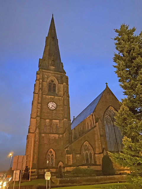
Hooley Bridge has a rich industrial history, closely linked to the textile industry that thrived in Lancashire during the 19th century. The village was once home to several cotton mills, which provided employment opportunities for the local population. Today, many of these mills have been converted into residential properties, adding a unique charm to the village's architecture.

The village has a close-knit community and offers a range of amenities for its residents. These include a primary school, a village hall, and a few local shops and pubs. Hooley Bridge is well-connected to nearby towns and cities, with regular bus services and easy access to the M62 motorway.

Overall, Hooley Bridge is a delightful village that combines natural beauty with a rich industrial heritage. Its idyllic setting, friendly community, and convenient location make it an attractive place to live or visit for those seeking a peaceful retreat in Lancashire.

If you have any feedback on the listing, please let us know in the comments section below.

Hooley Bridge Images

Images are sourced within 2km of 53.602551/-2.222868 or Grid Reference SD8511. Thanks to Geograph Open Source API. All images are credited.

Housing on Shaftesbury Drive This housing estate has no direct vehicle access across the nearby railway to reach the centre of Heywood. The residents have quite a drive to the nearest crossing.
Housing on Shaftesbury Drive
This housing estate has no direct vehicle access across the nearby railway to reach the centre of Heywood. The residents have quite a drive to the nearest crossing.
Entrance to Broadfield Business Park Off Pilsworth Road. There is a public bridleway (by the side of the gatehouse) behind the security fencing - not that you would recognise it.
Entrance to Broadfield Business Park
Off Pilsworth Road. There is a public bridleway (by the side of the gatehouse) behind the security fencing - not that you would recognise it.
WWII Lancashire: Ghost Signs of the Home Front  (12) -
Emergency Rendezvous Point, Peel Street, at junction with  Bury Street, Heywood, Bury 

"ERP ---?"

Emergency Rendezvous Points (ERP) were designated places in the locality for the coordination of ARP and emergency services during civil emergencies, particularly for those services arriving from outside the area. The signs appear in a variety of designs, but most are diamond shapes framing the ERP locality number.

<a href="https://www.geograph.org.uk/photo/6945275">SD8410 : WWII Lancashire: Ghost Signs of the Home Front  (13)</a>
WWII Lancashire: Ghost Signs of the Home Front (12)
- Emergency Rendezvous Point, Peel Street, at junction with Bury Street, Heywood, Bury "ERP ---?" Emergency Rendezvous Points (ERP) were designated places in the locality for the coordination of ARP and emergency services during civil emergencies, particularly for those services arriving from outside the area. The signs appear in a variety of designs, but most are diamond shapes framing the ERP locality number. SD8410 : WWII Lancashire: Ghost Signs of the Home Front (13)
WWII Lancashire: Ghost Signs of the Home Front  (13) -
Emergency Rendezvous Point, Peel Street, at junction with  Bury Street, Heywood, Bury 

"ERP ---?"

Emergency Rendezvous Points (ERP) were designated places in the locality for the coordination of ARP and emergency services during civil emergencies, particularly for those services arriving from outside the area. The signs appear in a variety of designs, but most are diamond shapes framing the ERP locality number.

<a href="https://www.geograph.org.uk/photo/6945286">SD8609 : WWII Lancashire: Ghost Signs of the Home Front (14)</a>
WWII Lancashire: Ghost Signs of the Home Front (13)
- Emergency Rendezvous Point, Peel Street, at junction with Bury Street, Heywood, Bury "ERP ---?" Emergency Rendezvous Points (ERP) were designated places in the locality for the coordination of ARP and emergency services during civil emergencies, particularly for those services arriving from outside the area. The signs appear in a variety of designs, but most are diamond shapes framing the ERP locality number. SD8609 : WWII Lancashire: Ghost Signs of the Home Front (14)
Heywood Church Spire - St Lukes
OS Cut Mark: Heywood - Number 6 Hind Hill Street <span class="nowrap"><a title="https://www.bench-marks.org.uk/bm109138" rel="nofollow ugc noopener" href="https://www.bench-marks.org.uk/bm109138">Link</a><img style="margin-left:2px;" alt="External link" title="External link - shift click to open in new window" src="https://s1.geograph.org.uk/img/external.png" width="10" height="10"/></span>
OS Cut Mark: Heywood - Number 6 Hind Hill Street
Mutual Mills, Heywood – 1 The tower of Mill No.1
Mutual Mills, Heywood – 1
The tower of Mill No.1
Mutual Mills, Heywood – 2 Office block of 1900 at Mill No.1, looking down Buckley Street.
Mutual Mills, Heywood – 2
Office block of 1900 at Mill No.1, looking down Buckley Street.
Mutual Mills, Heywood – 3 Aspinall Street facade of Mill No.1 and tower of Mill No.2
Mutual Mills, Heywood – 3
Aspinall Street facade of Mill No.1 and tower of Mill No.2
Mutual Mills, Heywood – 4 Razor wire tangle along Buckley Street.
Mutual Mills, Heywood – 4
Razor wire tangle along Buckley Street.
Mutual Mills, Heywood – 5 View from the entrance off Aspinall Street; Mill No.2 near left, Mills Nos.3 and 4 in the distance.
Mutual Mills, Heywood – 5
View from the entrance off Aspinall Street; Mill No.2 near left, Mills Nos.3 and 4 in the distance.
Mutual Mills, Heywood – 6 Warehouse and connecting corridor between Mills 2 and 3.
Mutual Mills, Heywood – 6
Warehouse and connecting corridor between Mills 2 and 3.
Mutual Mills, Heywood – 7 View across the lodge to Mill No.3; corner of Mill No.2 on left, and Mill No.4 on the right.
Mutual Mills, Heywood – 7
View across the lodge to Mill No.3; corner of Mill No.2 on left, and Mill No.4 on the right.
Mutual Mills, Heywood – 8 The south side of Mill No.1 with its tower.
Mutual Mills, Heywood – 8
The south side of Mill No.1 with its tower.
Mutual Mills, Heywood – 9 Tower reflection, Mill No.3.
Mutual Mills, Heywood – 9
Tower reflection, Mill No.3.
Mutual Mills, Heywood – 10 Mills 1 (left) and 2 (centre left) and connecting link seen across the lodge.
Mutual Mills, Heywood – 10
Mills 1 (left) and 2 (centre left) and connecting link seen across the lodge.
Mutual Mills, Heywood – 11 Tower of Mill No.3 and connecting link seen across the lodge.
Mutual Mills, Heywood – 11
Tower of Mill No.3 and connecting link seen across the lodge.
Mutual Mills, Heywood – 12 The east face of Mill No.1 showing engine house and later carding shed, the latter in red engineering brick.
Mutual Mills, Heywood – 12
The east face of Mill No.1 showing engine house and later carding shed, the latter in red engineering brick.
Show me another place!

Hooley Bridge is located at Grid Ref: SD8511 (Lat: 53.602551, Lng: -2.222868)

Unitary Authority: Rochdale

Police Authority: Greater Manchester

What 3 Words

///handle.motion.rival. Near Heywood, Manchester

Related Wikis

Queen's Park, Rochdale

Queen's Park is a public park in Heywood, in the Metropolitan Borough of Rochdale, Greater Manchester, England. == History == The park is situated on land...

Naden Brook

Naden Brook is a watercourse in northwest England. It rises in the hills above Norden, near the boundary of Lancashire and Greater Manchester. From here...

Wrigley Brook

Wrigley Brook is a culverted watercourse in Greater Manchester which flows through Heywood and is a tributary of the River Roch. Originating in the Hareshill...

Tack Lee Brook

Tack Lee Brook is a watercourse in Greater Manchester and a tributary of the River Roch. Birtle Brook is one of its tributaries.

Nearby Amenities

Located within 500m of 53.602551,-2.222868
Hooley Bridge
Is In: Heywood, Rochdale, Greater Manchester, England, UK
Place: suburb
Source: npe
Lat/Long: 53.6030715/-2.2228986
Turning Circle
Maxspeed: 20 mph
Lat/Long: 53.5995816/-2.2241673
Bus Stop
Queens Park Road/ Queens Park
Bus: yes
Naptan AtcoCode: 1800NE00141
Naptan Bearing: N
Naptan CommonName: Queens Park Road/ Queens Park
Naptan Indicator: School
Naptan Landmark: CAR Park
Naptan NaptanCode: mandtwmt
Naptan PlusbusZoneRef: MNCRPIC
Naptan ShortCommonName: Queens Park
Naptan Street: Queens Park Road
Naptan Verified: no
Network: TfGM
Public Transport: platform
Source: naptan_import
Lat/Long: 53.6012526/-2.2170477
Bus Stop
Queens Park Rd/Bury & Rochdale Old Rd
Bus: yes
Naptan AtcoCode: 1800NE00151
Naptan Bearing: N
Naptan CommonName: Queens Park Rd/Bury & Rochdale Old Rd
Naptan Indicator: Nr River
Naptan Landmark: NR RIVER
Naptan NaptanCode: mandtwmw
Naptan PlusbusZoneRef: MNCRPIC
Naptan ShortCommonName: Bury & Rochdale O
Naptan Street: Queens Park Road
Naptan Verified: no
Network: TfGM
Public Transport: platform
Source: naptan_import
Lat/Long: 53.6027265/-2.2171912
Bus Stop
Queens Park Rd/Bury & Rochdale Old Rd
Bus: yes
Naptan AtcoCode: 1800NE00311
Naptan Bearing: S
Naptan CommonName: Queens Park Rd/Bury & Rochdale Old Rd
Naptan Indicator: School
Naptan Landmark: SCHOOL
Naptan NaptanCode: mandtwpg
Naptan PlusbusZoneRef: MNCRPIC
Naptan ShortCommonName: Bury & Rochdale O
Naptan Street: Queens Park Road
Naptan Verified: no
Network: TfGM
Public Transport: platform
Source: naptan_import
Lat/Long: 53.6037513/-2.2171209
Bus Stop
Queens Park Road/Queens Park
Bus: yes
Naptan AtcoCode: 1800NE00411
Naptan Bearing: S
Naptan CommonName: Queens Park Road/Queens Park
Naptan Indicator: School
Naptan Landmark: PLAYGROUND
Naptan NaptanCode: mandwadm
Naptan PlusbusZoneRef: MNCRPIC
Naptan ShortCommonName: Queens Park
Naptan Street: Queens Park Road
Naptan Verified: no
Network: TfGM
Public Transport: platform
Source: naptan_import
Lat/Long: 53.6006509/-2.2167877
Bus Stop
Furness Avenue/Whitby Avenue
Bus: yes
Naptan AtcoCode: 1800NE04121
Naptan Bearing: S
Naptan CommonName: Furness Avenue/Whitby Avenue
Naptan Indicator: Nr House 90
Naptan Landmark: HOUSE 90
Naptan NaptanCode: mandwjpd
Naptan PlusbusZoneRef: MNCRPIC
Naptan ShortCommonName: Whitby Avenue
Naptan Street: FURNESS AVENUE
Naptan Verified: no
Network: TfGM
Public Transport: platform
Source: naptan_import
Lat/Long: 53.5995569/-2.2250931
Bus Stop
Cedar Avenue/Lime Grove
Bus: yes
Naptan AtcoCode: 1800NE04891
Naptan Bearing: NE
Naptan CommonName: Cedar Avenue/Lime Grove
Naptan Indicator: House 79
Naptan Landmark: House 81
Naptan NaptanCode: mantgdta
Naptan Notes: INDICATOR AMENDED
Naptan PlusbusZoneRef: MNCRPIC
Naptan ShortCommonName: Lime Grove
Naptan Street: Cedar Avenue
Naptan Verified: no
Network: TfGM
Public Transport: platform
Source: naptan_import
Lat/Long: 53.5991121/-2.2274027
Bus Stop
Furness Avenue/Whitby Avenue
Bus: yes
Naptan AtcoCode: 1800NE05421
Naptan Bearing: N
Naptan CommonName: Furness Avenue/Whitby Avenue
Naptan Indicator: Nr House 90
Naptan Landmark: HOUSE 93
Naptan NaptanCode: mantgtaw
Naptan PlusbusZoneRef: MNCRPIC
Naptan ShortCommonName: Whitby Avenue
Naptan Street: FURNESS AVENUE
Naptan Verified: no
Network: TfGM
Public Transport: platform
Source: naptan_import
Lat/Long: 53.5995297/-2.2252441
Bus Stop
Cedar Avenue/Lime Grove
Bus: yes
Naptan AtcoCode: 1800NE06711
Naptan Bearing: SW
Naptan CommonName: Cedar Avenue/Lime Grove
Naptan Indicator: House 79
Naptan Landmark: House 80
Naptan NaptanCode: mantgtdp
Naptan Notes: INDICATOR AMENDED
Naptan PlusbusZoneRef: MNCRPIC
Naptan ShortCommonName: Lime Grove
Naptan Street: Cedar Avenue
Naptan Verified: no
Network: TfGM
Public Transport: platform
Source: naptan_import
Lat/Long: 53.5990494/-2.2273117
Bus Stop
Bury and Rochdale Old Road/Ashworth Road
Bus: yes
Naptan AtcoCode: 1800NE44241
Naptan Bearing: E
Naptan CommonName: Bury and Rochdale Old Road/Ashworth Road
Naptan Indicator: Nr Open Land
Naptan Landmark: NR OPEN LAND
Naptan NaptanCode: mangdpjm
Naptan PlusbusZoneRef: MNCRPIC
Naptan ShortCommonName: Ashworth Road
Naptan Street: Bury And Rochdale Old Road
Naptan Verified: no
Network: TfGM
Public Transport: platform
Source: naptan_import
Lat/Long: 53.6048866/-2.2253482
Bus Stop
Bury and Rochdale Old Road/Bamford Road
Bus: yes
Naptan AtcoCode: 1800NE44251
Naptan Bearing: W
Naptan CommonName: Bury and Rochdale Old Road/Bamford Road
Naptan Indicator: Nr House 164
Naptan Landmark: PARK
Naptan NaptanCode: mangdpjp
Naptan Notes: INDICATOR AMENDED
Naptan PlusbusZoneRef: MNCRPIC
Naptan ShortCommonName: Bamford Road
Naptan Street: Bury And Rochdale Old Road
Naptan Verified: no
Network: TfGM
Public Transport: platform
Source: naptan_import
Lat/Long: 53.6045122/-2.2236989
Bus Stop
Bury & Rochdale Old Rd/Bamford Rd
Bus: yes
Naptan AtcoCode: 1800NE44261
Naptan Bearing: E
Naptan CommonName: Bury & Rochdale Old Rd/Bamford Rd
Naptan Indicator: Nr Open Land
Naptan Landmark: NR OPEN LAND
Naptan NaptanCode: mangdpjt
Naptan PlusbusZoneRef: MNCRPIC
Naptan ShortCommonName: Bamford Rd
Naptan Street: Bury And Rochdale Old Road
Naptan Verified: no
Network: TfGM
Public Transport: platform
Source: naptan_import
Lat/Long: 53.6045848/-2.2233517
Bus Stop
Bury & Rochdale Old Rd/Queens Park Rd
Bus: yes
Naptan AtcoCode: 1800NE44271
Naptan Bearing: W
Naptan CommonName: Bury & Rochdale Old Rd/Queens Park Rd
Naptan Indicator: School
Naptan Landmark: SCHOOL
Naptan NaptanCode: mangdpjw
Naptan PlusbusZoneRef: MNCRPIC
Naptan ShortCommonName: Queens Park Rd
Naptan Street: Bury And Rochdale Old Road
Naptan Verified: no
Network: TfGM
Public Transport: platform
Source: naptan_import
Lat/Long: 53.6049273/-2.2179431
Bus Stop
Bury & Rochdale Old Rd/Queens Park Rd
Bus: yes
Naptan AtcoCode: 1800NE44281
Naptan Bearing: E
Naptan CommonName: Bury & Rochdale Old Rd/Queens Park Rd
Naptan Indicator: Church
Naptan Landmark: CHURCH
Naptan NaptanCode: mangdpma
Naptan PlusbusZoneRef: MNCRPIC
Naptan ShortCommonName: Queens Park Rd
Naptan Street: Bury And Rochdale Old Road
Naptan Verified: no
Network: TfGM
Public Transport: platform
Source: naptan_import
Lat/Long: 53.6050891/-2.2179288
Bus Stop
Bamford Road/Heywood Hall Road
Bus: yes
Naptan AtcoCode: 1800NE32141
Naptan Bearing: S
Naptan CommonName: Bamford Road/Heywood Hall Road
Naptan Indicator: O/s House 170
Naptan Landmark: HOUSE 178
Naptan NaptanCode: mangdgad
Naptan PlusbusZoneRef: MNCRPIC
Naptan ShortCommonName: Heywood Hall Road
Naptan Street: BAMFORD ROAD
Naptan Verified: no
Network: TfGM
Public Transport: platform
Source: naptan_import
Lat/Long: 53.598532/-2.2204034
Bus Stop
Bamford Road/Heywood Hall Road
Bus: yes
Naptan AtcoCode: 1800NE32151
Naptan Bearing: N
Naptan CommonName: Bamford Road/Heywood Hall Road
Naptan Indicator: Op House 182
Naptan Landmark: HOUSE 7
Naptan NaptanCode: mangdgag
Naptan PlusbusZoneRef: MNCRPIC
Naptan ShortCommonName: Heywood Hall Road
Naptan Street: BAMFORD ROAD
Naptan Verified: no
Network: TfGM
Public Transport: platform
Source: naptan_import
Lat/Long: 53.5989721/-2.2205417
Bus Stop
Clay Bank Street/Furness Avenue
Bus: yes
Naptan AtcoCode: 1800NE32161
Naptan Bearing: W
Naptan CommonName: Clay Bank Street/Furness Avenue
Naptan Indicator: O/s House 67
Naptan Landmark: HOUSE 67
Naptan NaptanCode: mangdgaj
Naptan PlusbusZoneRef: MNCRPIC
Naptan ShortCommonName: Furness Avenue
Naptan Street: Claybank Street
Naptan Verified: no
Network: TfGM
Public Transport: platform
Source: naptan_import
Lat/Long: 53.5983723/-2.2241047
Bus Stop
Clay Bank Street/Furness Avenue
Bus: yes
Naptan AtcoCode: 1800NE32171
Naptan Bearing: E
Naptan CommonName: Clay Bank Street/Furness Avenue
Naptan Indicator: O/s House 66
Naptan Landmark: HOUSE 66
Naptan NaptanCode: mangdgam
Naptan PlusbusZoneRef: MNCRPIC
Naptan ShortCommonName: Furness Avenue
Naptan Street: Claybank Street
Naptan Verified: no
Network: TfGM
Public Transport: platform
Source: naptan_import
Lat/Long: 53.5985529/-2.2236372
Bus Stop
Bamford Road/Hooley Bridge
Bus: yes
Naptan AtcoCode: 1800NE32201
Naptan Bearing: S
Naptan CommonName: Bamford Road/Hooley Bridge
Naptan Indicator: Coll Sew Machne
Naptan Landmark: COLL SEW MACHNE
Naptan NaptanCode: mangdgap
Naptan PlusbusZoneRef: MNCRPIC
Naptan ShortCommonName: Hooley Bridge
Naptan Street: BAMFORD ROAD
Naptan Verified: no
Network: TfGM
Public Transport: platform
Source: naptan_import
Lat/Long: 53.6013159/-2.2217628
Bus Stop
Bamford Road/Hooley Bridge
Bus: yes
Naptan AtcoCode: 1800NE32211
Naptan Bearing: NW
Naptan CommonName: Bamford Road/Hooley Bridge
Naptan Indicator: Derelict Mill
Naptan Landmark: DERELICT MILL
Naptan NaptanCode: mangdgat
Naptan PlusbusZoneRef: MNCRPIC
Naptan ShortCommonName: Hooley Bridge
Naptan Street: BAMFORD ROAD
Naptan Verified: no
Network: TfGM
Public Transport: platform
Source: naptan_import
Lat/Long: 53.601423/-2.2221563
Bus Stop
Bamford Road/Bury and Rochdale Old Road
Bus: yes
Naptan AtcoCode: 1800NE32221
Naptan Bearing: N
Naptan CommonName: Bamford Road/Bury and Rochdale Old Road
Naptan Indicator: Nr Open Land
Naptan Landmark: NR OPEN LAND
Naptan NaptanCode: mangdgaw
Naptan PlusbusZoneRef: MNCRPIC
Naptan ShortCommonName: Bury and Rochdale
Naptan Street: BAMFORD ROAD
Naptan Verified: no
Network: TfGM
Public Transport: platform
Source: naptan_import
Lat/Long: 53.6042706/-2.2231233
Bus Stop
Bamford Road/Victoria Terrace
Bus: yes
Naptan AtcoCode: 1800NE32231
Naptan Bearing: N
Naptan CommonName: Bamford Road/Victoria Terrace
Naptan Indicator: O/s House 209
Naptan Landmark: HOUSE 209
Naptan NaptanCode: mangdgda
Naptan PlusbusZoneRef: MNCRPIC
Naptan ShortCommonName: Victoria Terrace
Naptan Street: BAMFORD ROAD
Naptan Verified: no
Network: TfGM
Public Transport: platform
Source: naptan_import
Lat/Long: 53.6026874/-2.2237497
Bus Stop
Bamford Road/Bury and Rochdale Old Road
Bus: yes
Naptan AtcoCode: 1800NE32241
Naptan Bearing: S
Naptan CommonName: Bamford Road/Bury and Rochdale Old Road
Naptan Indicator: Opp House 203
Naptan Landmark: OPP HOUSE
Naptan NaptanCode: mangdgdg
Naptan Notes: INDICATOR AMENDED
Naptan PlusbusZoneRef: MNCRPIC
Naptan ShortCommonName: Bury and Rochdale
Naptan Street: BAMFORD ROAD
Naptan Verified: no
Network: TfGM
Public Transport: platform
Source: naptan_import
Lat/Long: 53.6042169/-2.2230173
Bus Stop
Bamford Road/Victoria Terrace
Bus: yes
Naptan AtcoCode: 1800NE32251
Naptan Bearing: S
Naptan CommonName: Bamford Road/Victoria Terrace
Naptan Indicator: Opp House 205
Naptan Landmark: HOUSE 205
Naptan NaptanCode: mangdgdj
Naptan PlusbusZoneRef: MNCRPIC
Naptan ShortCommonName: Victoria Terrace
Naptan Street: BAMFORD ROAD
Naptan Verified: no
Network: TfGM
Public Transport: platform
Source: naptan_import
Lat/Long: 53.6026247/-2.2236285
Waterway: weir
Lat/Long: 53.6034836/-2.2284763
Barrier: cycle_barrier
Bicycle: dismount
Foot: yes
Wheelchair: no
Lat/Long: 53.6037387/-2.2269885
Barrier: bollard
Lat/Long: 53.6000148/-2.2238001
Barrier: yes
Lat/Long: 53.6025726/-2.2193282
Generator Method: photovoltaic
Generator Output Electricity: yes
Generator Source: solar
Generator Type: solar_photovoltaic_panel
Location: roof
Power: generator
Lat/Long: 53.6032461/-2.2189334
Generator Method: photovoltaic
Generator Output Electricity: yes
Generator Source: solar
Generator Type: solar_photovoltaic_panel
Location: roof
Power: generator
Lat/Long: 53.6024376/-2.2225557
Generator Method: photovoltaic
Generator Output Electricity: yes
Generator Source: solar
Generator Type: solar_photovoltaic_panel
Location: roof
Power: generator
Lat/Long: 53.5986164/-2.2255711
Generator Method: photovoltaic
Generator Output Electricity: yes
Generator Source: solar
Generator Type: solar_photovoltaic_panel
Location: roof
Power: generator
Lat/Long: 53.5986473/-2.2193552
Barrier: block
Bicycle: yes
Foot: yes
Motor Vehicle: no
Wheelchair: yes
Lat/Long: 53.5982463/-2.2244368
Barrier: cycle_barrier
Foot: yes
Wheelchair: limited
Lat/Long: 53.6007167/-2.2260038
Crossing
Crossing: traffic_signals
Crossing Island: no
Crossing Markings: dots
Tactile Paving: yes
Lat/Long: 53.6007377/-2.2169069
The data included in this document is from www.openstreetmap.org. The data is made available under ODbL.

Have you been to Hooley Bridge?

Leave your review of Hooley Bridge below (or comments, questions and feedback).