Plumpton Wood

Wood, Forest in Lancashire

England

Plumpton Wood

WWII Lancashire: Ghost Signs of the Home Front  (12) -
Emergency Rendezvous Point, Peel Street, at junction with  Bury Street, Heywood, Bury 

"ERP ---?"

Emergency Rendezvous Points (ERP) were designated places in the locality for the coordination of ARP and emergency services during civil emergencies, particularly for those services arriving from outside the area. The signs appear in a variety of designs, but most are diamond shapes framing the ERP locality number.

<a href="https://www.geograph.org.uk/photo/6945275">SD8410 : WWII Lancashire: Ghost Signs of the Home Front  (13)</a>
WWII Lancashire: Ghost Signs of the Home Front (12) Credit: Mike Searle

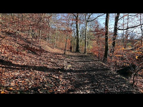
Plumpton Wood is a picturesque forest located in the county of Lancashire, England. Covering an area of approximately 200 acres, it is nestled within the beautiful countryside, providing a serene and tranquil escape for nature lovers and outdoor enthusiasts.

The wood is characterized by a diverse range of tree species, including oak, beech, birch, and ash, which create a rich and vibrant canopy overhead. The forest floor is adorned with a plethora of wildflowers and ferns, adding to the overall enchanting atmosphere of the wood.

Plumpton Wood boasts a network of well-maintained paths and trails, offering visitors the opportunity to explore its natural wonders. These paths lead to hidden clearings and secluded spots, perfect for picnics or simply enjoying the peaceful surroundings.

The wood is also home to a variety of wildlife. Birdwatchers can spot species such as woodpeckers, owls, and thrushes, while lucky visitors may even catch a glimpse of elusive mammals like deer and foxes. The diverse ecosystem of Plumpton Wood provides an important habitat for many species, contributing to the overall biodiversity of the region.

Throughout the year, Plumpton Wood showcases the beauty of each season. In spring, the forest bursts into life with a vibrant display of blossoming flowers, while autumn brings a mesmerizing array of colors as the leaves change. Even in winter, the wood retains its charm, with frost-covered branches creating a magical landscape.

Overall, Plumpton Wood is a true gem in Lancashire, offering visitors a chance to immerse themselves in the wonders of nature and experience the tranquility of a beautiful forest setting.

If you have any feedback on the listing, please let us know in the comments section below.

Plumpton Wood Images

Images are sourced within 2km of 53.603495/-2.2155491 or Grid Reference SD8511. Thanks to Geograph Open Source API. All images are credited.

WWII Lancashire: Ghost Signs of the Home Front  (12) -
Emergency Rendezvous Point, Peel Street, at junction with  Bury Street, Heywood, Bury 

"ERP ---?"

Emergency Rendezvous Points (ERP) were designated places in the locality for the coordination of ARP and emergency services during civil emergencies, particularly for those services arriving from outside the area. The signs appear in a variety of designs, but most are diamond shapes framing the ERP locality number.

<a href="https://www.geograph.org.uk/photo/6945275">SD8410 : WWII Lancashire: Ghost Signs of the Home Front  (13)</a>
WWII Lancashire: Ghost Signs of the Home Front (12)
- Emergency Rendezvous Point, Peel Street, at junction with Bury Street, Heywood, Bury "ERP ---?" Emergency Rendezvous Points (ERP) were designated places in the locality for the coordination of ARP and emergency services during civil emergencies, particularly for those services arriving from outside the area. The signs appear in a variety of designs, but most are diamond shapes framing the ERP locality number. SD8410 : WWII Lancashire: Ghost Signs of the Home Front (13)
WWII Lancashire: Ghost Signs of the Home Front  (13) -
Emergency Rendezvous Point, Peel Street, at junction with  Bury Street, Heywood, Bury 

"ERP ---?"

Emergency Rendezvous Points (ERP) were designated places in the locality for the coordination of ARP and emergency services during civil emergencies, particularly for those services arriving from outside the area. The signs appear in a variety of designs, but most are diamond shapes framing the ERP locality number.

<a href="https://www.geograph.org.uk/photo/6945286">SD8609 : WWII Lancashire: Ghost Signs of the Home Front (14)</a>
WWII Lancashire: Ghost Signs of the Home Front (13)
- Emergency Rendezvous Point, Peel Street, at junction with Bury Street, Heywood, Bury "ERP ---?" Emergency Rendezvous Points (ERP) were designated places in the locality for the coordination of ARP and emergency services during civil emergencies, particularly for those services arriving from outside the area. The signs appear in a variety of designs, but most are diamond shapes framing the ERP locality number. SD8609 : WWII Lancashire: Ghost Signs of the Home Front (14)
Heywood Church Spire - St Lukes
OS Cut Mark: Heywood - Number 6 Hind Hill Street <span class="nowrap"><a title="https://www.bench-marks.org.uk/bm109138" rel="nofollow ugc noopener" href="https://www.bench-marks.org.uk/bm109138">Link</a><img style="margin-left:2px;" alt="External link" title="External link - shift click to open in new window" src="https://s1.geograph.org.uk/img/external.png" width="10" height="10"/></span>
OS Cut Mark: Heywood - Number 6 Hind Hill Street
The Harrows, Bolton Road, Rochdale See <a href="https://www.geograph.org.uk/photo/1743544">SD8711 : The Harrows</a> for another view.
The Harrows, Bolton Road, Rochdale
See SD8711 : The Harrows for another view.
The Anti Ageing Clinic, Crescent Road, Rochdale
Crescent Road, Rochdale Just a short section of a fairly long residential road with a mixture of, probably, ex-Local Authority housing & private terraced housing.
Crescent Road, Rochdale
Just a short section of a fairly long residential road with a mixture of, probably, ex-Local Authority housing & private terraced housing.
Success to the Plough, Bolton Road, Rochdale Situated at the corner of Matthew Moss Lane, with a bowling green at the rear. At present there are 2 other images on here, both taken looking south east, in sun. This is looking south west, in steady rain.
Success to the Plough, Bolton Road, Rochdale
Situated at the corner of Matthew Moss Lane, with a bowling green at the rear. At present there are 2 other images on here, both taken looking south east, in sun. This is looking south west, in steady rain.
George V Postbox, Bolton Road, Marland, Rochdale Postbox No. OL11 45D, situated at the corner of Marland Fold, near the entrance to Springfield Park.
George V Postbox, Bolton Road, Marland, Rochdale
Postbox No. OL11 45D, situated at the corner of Marland Fold, near the entrance to Springfield Park.
Springfield Park, Rochdale Photo taken from just inside the entrance on Bolton Road.
Springfield Park, Rochdale
Photo taken from just inside the entrance on Bolton Road.
Matthew Moss Lane, Rochdale Looking towards Bolton Road from Crescent Road, with Matthew Moss High School on the left.
Matthew Moss Lane, Rochdale
Looking towards Bolton Road from Crescent Road, with Matthew Moss High School on the left.
Matthew Moss Youth Centre, Rochdale Situated on Matthew Moss Lane, next to the High School.
Matthew Moss Youth Centre, Rochdale
Situated on Matthew Moss Lane, next to the High School.
Terraced Houses on Crescent Road, Rochdale
The former Phoenix Brewery, Heywood – 1 I haven't worked out what the function of the buildings in the foreground was.
The former Phoenix Brewery, Heywood – 1
I haven't worked out what the function of the buildings in the foreground was.
The former Phoenix Brewery, Heywood – 2 This range may have been the stable block, now occupied by various small businesses.
The former Phoenix Brewery, Heywood – 2
This range may have been the stable block, now occupied by various small businesses.
The former Phoenix Brewery, Heywood – 3 Terracotta date plaque on the stable block. The whole set of brewery buildings appears to date from 1899, although the 1894 6-inch mapping shows buildings with a similar footprint already in existence.
The former Phoenix Brewery, Heywood – 3
Terracotta date plaque on the stable block. The whole set of brewery buildings appears to date from 1899, although the 1894 6-inch mapping shows buildings with a similar footprint already in existence.
The former Phoenix Brewery, Heywood – 4 The brewing tower, now out of use except as a support for communications transmitters.
The former Phoenix Brewery, Heywood – 4
The brewing tower, now out of use except as a support for communications transmitters.
The former Phoenix Brewery, Heywood – 5 The main brewery yard. The brewery closed in around 1960, but the 'Oak Brewing Company' of Ellesmere Port relocated here in 1991 and became Phoenix Brewing Ltd in 1996. It occupies the former maltings and office buildings and doesn't not 'replicate' the original brewery.
The former Phoenix Brewery, Heywood – 5
The main brewery yard. The brewery closed in around 1960, but the 'Oak Brewing Company' of Ellesmere Port relocated here in 1991 and became Phoenix Brewing Ltd in 1996. It occupies the former maltings and office buildings and doesn't not 'replicate' the original brewery.
Show me another place!

Plumpton Wood is located at Grid Ref: SD8511 (Lat: 53.603495, Lng: -2.2155491)

Unitary Authority: Rochdale

Police Authority: Greater Manchester

What 3 Words

///shuts.zone.gives. Near Heywood, Manchester

Related Wikis

Queen's Park, Rochdale

Queen's Park is a public park in Heywood, in the Metropolitan Borough of Rochdale, Greater Manchester, England. == History == The park is situated on land...

Millers Brook

Millers Brook is a watercourse in Greater Manchester and tributary of the River Roch. It originates in Heywood and flows through Queens Park to join the...

Naden Brook

Naden Brook is a watercourse in northwest England. It rises in the hills above Norden, near the boundary of Lancashire and Greater Manchester. From here...

Wrigley Brook

Wrigley Brook is a culverted watercourse in Greater Manchester which flows through Heywood and is a tributary of the River Roch. Originating in the Hareshill...

Related Videos

Queens Park, Crimble & the River Roch Heywood

A short relaxing walk from Queens Park Heywood. There was some rather delicate fancy footwork went into this walk. Navigating ...

Heywood / Lancashire / England 🏴󠁧󠁢󠁥󠁮󠁧󠁿

The sun setting in the town of Heywood Lancashire…..wow purple Skys! Enjoy guys and girls, please if you like my content hit the ...

Ashworth Waterfall COLD WATER Dipping & WALKING! Lancashire Walks.

Another day, another cold water dip in Lancashire. Ashworth Waterfall in Heywood/Rochdale area.

Ashworth Waterfall

A short walk to swim in the Ashworth Waterfall Starting from the car park in Norden: OL11 5SN.

Nearby Amenities

Located within 500m of 53.603495,-2.2155491
Hooley Bridge
Is In: Heywood, Rochdale, Greater Manchester, England, UK
Place: suburb
Source: npe
Lat/Long: 53.6030715/-2.2228986
Bus Stop
Queens Park Road/ Queens Park
Bus: yes
Naptan AtcoCode: 1800NE00141
Naptan Bearing: N
Naptan CommonName: Queens Park Road/ Queens Park
Naptan Indicator: School
Naptan Landmark: CAR Park
Naptan NaptanCode: mandtwmt
Naptan PlusbusZoneRef: MNCRPIC
Naptan ShortCommonName: Queens Park
Naptan Street: Queens Park Road
Naptan Verified: no
Network: TfGM
Public Transport: platform
Source: naptan_import
Lat/Long: 53.6012526/-2.2170477
Bus Stop
Queens Park Rd/Bury & Rochdale Old Rd
Bus: yes
Naptan AtcoCode: 1800NE00151
Naptan Bearing: N
Naptan CommonName: Queens Park Rd/Bury & Rochdale Old Rd
Naptan Indicator: Nr River
Naptan Landmark: NR RIVER
Naptan NaptanCode: mandtwmw
Naptan PlusbusZoneRef: MNCRPIC
Naptan ShortCommonName: Bury & Rochdale O
Naptan Street: Queens Park Road
Naptan Verified: no
Network: TfGM
Public Transport: platform
Source: naptan_import
Lat/Long: 53.6027265/-2.2171912
Bus Stop
Queens Park Rd/Bury & Rochdale Old Rd
Bus: yes
Naptan AtcoCode: 1800NE00311
Naptan Bearing: S
Naptan CommonName: Queens Park Rd/Bury & Rochdale Old Rd
Naptan Indicator: School
Naptan Landmark: SCHOOL
Naptan NaptanCode: mandtwpg
Naptan PlusbusZoneRef: MNCRPIC
Naptan ShortCommonName: Bury & Rochdale O
Naptan Street: Queens Park Road
Naptan Verified: no
Network: TfGM
Public Transport: platform
Source: naptan_import
Lat/Long: 53.6037513/-2.2171209
Bus Stop
Queens Park Road/Queens Park
Bus: yes
Naptan AtcoCode: 1800NE00411
Naptan Bearing: S
Naptan CommonName: Queens Park Road/Queens Park
Naptan Indicator: School
Naptan Landmark: PLAYGROUND
Naptan NaptanCode: mandwadm
Naptan PlusbusZoneRef: MNCRPIC
Naptan ShortCommonName: Queens Park
Naptan Street: Queens Park Road
Naptan Verified: no
Network: TfGM
Public Transport: platform
Source: naptan_import
Lat/Long: 53.6006509/-2.2167877
Bus Stop
Bury & Rochdale Old Rd/Queens Park Rd
Bus: yes
Naptan AtcoCode: 1800NE44271
Naptan Bearing: W
Naptan CommonName: Bury & Rochdale Old Rd/Queens Park Rd
Naptan Indicator: School
Naptan Landmark: SCHOOL
Naptan NaptanCode: mangdpjw
Naptan PlusbusZoneRef: MNCRPIC
Naptan ShortCommonName: Queens Park Rd
Naptan Street: Bury And Rochdale Old Road
Naptan Verified: no
Network: TfGM
Public Transport: platform
Source: naptan_import
Lat/Long: 53.6049273/-2.2179431
Bus Stop
Bury & Rochdale Old Rd/Queens Park Rd
Bus: yes
Naptan AtcoCode: 1800NE44281
Naptan Bearing: E
Naptan CommonName: Bury & Rochdale Old Rd/Queens Park Rd
Naptan Indicator: Church
Naptan Landmark: CHURCH
Naptan NaptanCode: mangdpma
Naptan PlusbusZoneRef: MNCRPIC
Naptan ShortCommonName: Queens Park Rd
Naptan Street: Bury And Rochdale Old Road
Naptan Verified: no
Network: TfGM
Public Transport: platform
Source: naptan_import
Lat/Long: 53.6050891/-2.2179288
Bus Stop
Bury & Rochdale Old Rd/Heywood Boundary
Bus: yes
Naptan AtcoCode: 1800NE44311
Naptan Bearing: W
Naptan CommonName: Bury & Rochdale Old Rd/Heywood Boundary
Naptan Indicator: Opp House 383
Naptan Landmark: Vicarage
Naptan NaptanCode: mangdpmj
Naptan PlusbusZoneRef: MNCRPIC
Naptan ShortCommonName: Heywood Boundary
Naptan Street: Bury Rocdale Road
Naptan Verified: no
Network: TfGM
Public Transport: platform
Source: naptan_import
Lat/Long: 53.6066552/-2.2117856
Bus Stop
Bury & Rochdale Old Rd/Heywood Boundary
Bus: yes
Naptan AtcoCode: 1800NE44321
Naptan Bearing: E
Naptan CommonName: Bury & Rochdale Old Rd/Heywood Boundary
Naptan Indicator: Nr Vicarage
Naptan Landmark: NR VICARAGE
Naptan NaptanCode: mangdpmp
Naptan PlusbusZoneRef: MNCRPIC
Naptan ShortCommonName: Heywood Boundary
Naptan Street: Bury And Rochdale Old Road
Naptan Verified: no
Network: TfGM
Public Transport: platform
Source: naptan_import
Lat/Long: 53.6068899/-2.2111823
Bus Stop
Bamford Road/Hooley Bridge
Bus: yes
Naptan AtcoCode: 1800NE32201
Naptan Bearing: S
Naptan CommonName: Bamford Road/Hooley Bridge
Naptan Indicator: Coll Sew Machne
Naptan Landmark: COLL SEW MACHNE
Naptan NaptanCode: mangdgap
Naptan PlusbusZoneRef: MNCRPIC
Naptan ShortCommonName: Hooley Bridge
Naptan Street: BAMFORD ROAD
Naptan Verified: no
Network: TfGM
Public Transport: platform
Source: naptan_import
Lat/Long: 53.6013159/-2.2217628
Bus Stop
Bamford Road/Hooley Bridge
Bus: yes
Naptan AtcoCode: 1800NE32211
Naptan Bearing: NW
Naptan CommonName: Bamford Road/Hooley Bridge
Naptan Indicator: Derelict Mill
Naptan Landmark: DERELICT MILL
Naptan NaptanCode: mangdgat
Naptan PlusbusZoneRef: MNCRPIC
Naptan ShortCommonName: Hooley Bridge
Naptan Street: BAMFORD ROAD
Naptan Verified: no
Network: TfGM
Public Transport: platform
Source: naptan_import
Lat/Long: 53.601423/-2.2221563
Bus Stop
Bamford Road/Bury and Rochdale Old Road
Bus: yes
Naptan AtcoCode: 1800NE32241
Naptan Bearing: S
Naptan CommonName: Bamford Road/Bury and Rochdale Old Road
Naptan Indicator: Opp House 203
Naptan Landmark: OPP HOUSE
Naptan NaptanCode: mangdgdg
Naptan Notes: INDICATOR AMENDED
Naptan PlusbusZoneRef: MNCRPIC
Naptan ShortCommonName: Bury and Rochdale
Naptan Street: BAMFORD ROAD
Naptan Verified: no
Network: TfGM
Public Transport: platform
Source: naptan_import
Lat/Long: 53.6042169/-2.2230173
Barrier: yes
Lat/Long: 53.6025726/-2.2193282
Generator Method: photovoltaic
Generator Output Electricity: yes
Generator Source: solar
Generator Type: solar_photovoltaic_panel
Location: roof
Power: generator
Lat/Long: 53.6067921/-2.2124223
Generator Method: photovoltaic
Generator Output Electricity: yes
Generator Source: solar
Generator Type: solar_photovoltaic_panel
Location: roof
Power: generator
Lat/Long: 53.6032461/-2.2189334
Generator Method: photovoltaic
Generator Output Electricity: yes
Generator Source: solar
Generator Type: solar_photovoltaic_panel
Location: roof
Power: generator
Lat/Long: 53.6024376/-2.2225557
Crossing
Lat/Long: 53.6041417/-2.2085073
Crossing
Crossing: marked
Lat/Long: 53.6060124/-2.2152238
Crossing
Crossing: marked
Lat/Long: 53.6060745/-2.2149796
Fountain
Fountain: decorative
Lat/Long: 53.6007458/-2.2153725
Crossing
Crossing: traffic_signals
Crossing Island: no
Crossing Markings: dots
Tactile Paving: yes
Lat/Long: 53.6007377/-2.2169069
The data included in this document is from www.openstreetmap.org. The data is made available under ODbL.

Have you been to Plumpton Wood?

Leave your review of Plumpton Wood below (or comments, questions and feedback).