Cnoc nan Tarbh
Hill, Mountain in Ross-shire
Scotland
Cnoc nan Tarbh

Cnoc nan Tarbh is a prominent hill located in Ross-shire, Scotland. It is part of the Northwest Highlands and is situated near the village of Muir of Ord. The hill stands at an elevation of approximately 555 meters (1,821 feet) above sea level, making it a popular destination for hikers and outdoor enthusiasts.
The name Cnoc nan Tarbh translates from Scottish Gaelic to "Hill of the Bulls," which is thought to refer to the presence of wild cattle in the area historically. The hill offers breathtaking panoramic views of the surrounding countryside, including the nearby Beauly Firth and the mountains of Strathconon.
The ascent to the summit of Cnoc nan Tarbh provides a moderately challenging hike, with a well-defined path leading to the top. The terrain consists of heather-covered slopes, rocky outcrops, and boggy patches. Hikers can expect to encounter various wildlife, including red deer, golden eagles, and mountain hares.
The hill is accessible year-round, but it is advisable to check weather conditions and be prepared for changing weather, as the Scottish Highlands are known for their unpredictable climate. It is also recommended to wear appropriate footwear and carry essential supplies, including maps, compasses, and food and water.
Cnoc nan Tarbh offers visitors an opportunity to experience the natural beauty and tranquility of the Scottish Highlands. Whether it is for a leisurely hike or a more challenging adventure, this hill provides a rewarding outdoor experience for nature enthusiasts and those seeking stunning views of the surrounding landscape.
If you have any feedback on the listing, please let us know in the comments section below.
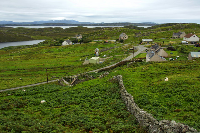
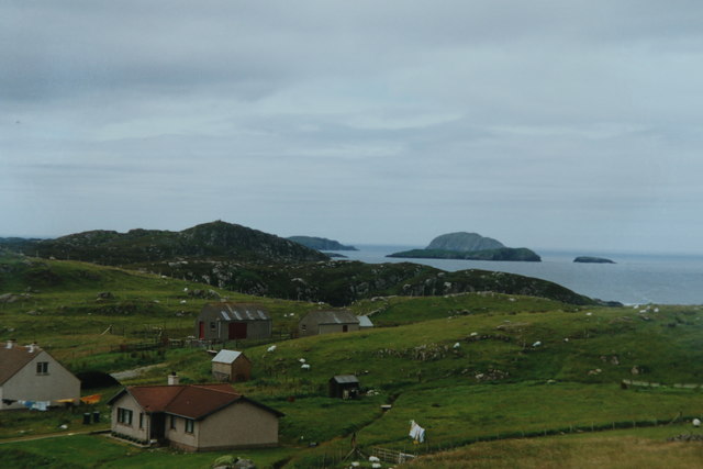
Cnoc nan Tarbh Images
Images are sourced within 2km of 58.286592/-6.8060943 or Grid Reference NB1843. Thanks to Geograph Open Source API. All images are credited.


Cnoc nan Tarbh is located at Grid Ref: NB1843 (Lat: 58.286592, Lng: -6.8060943)
Unitary Authority: Na h-Eileanan an Iar
Police Authority: Highlands and Islands
What 3 Words
///fevered.recorders.props. Near Carloway, Na h-Eileanan Siar
Nearby Locations
Related Wikis

Borrowston, Lewis
Borrowston (Scottish Gaelic: Borghastan), with a population of about 50, is a crofting township situated on the Isle of Lewis, on the Outer Hebrides of...

Garenin
Garenin (Scottish Gaelic: Na Gearrannan) is a crofting township on the west coast of the Isle of Lewis in the Outer Hebrides of Scotland. Garenin is in...

Dun Carloway
Dun Carloway (Scottish Gaelic: Dùn Chàrlabhaigh) is a broch situated in the district of Carloway, on the west coast of the Isle of Lewis, Scotland (grid...

Carloway
Carloway (Scottish Gaelic: Càrlabhagh [ˈkʰaːɾɫ̪ə.ɤː]) is a crofting township and a district on the west coast of the Isle of Lewis, in the Outer Hebrides...

Cealasaigh
Cealasaigh or Kealasay is an islet in outer Loch Ròg, Lewis, Scotland that lies north of Traigh Mhór on Little Bernera and south of Campaigh. To the west...

Campaigh
Campaigh or Campay is a steep and rocky islet in outer Loch Ròg, Lewis, Scotland that lies north of Cealasaigh and Little Bernera. A huge natural arch...

Little Bernera
Little Bernera (Scottish Gaelic: Beàrnaraigh Beag) is a small island situated off the west coast of the Isle of Lewis in the Outer Hebrides.Little Bernera...

Tolsta Chaolais
Tolsta Chaolais (also Tolastadh Chaolais, Tolstadh a' Chaolais) is a village on the Isle of Lewis, Scotland. It consists of about forty houses, clustered...
Have you been to Cnoc nan Tarbh?
Leave your review of Cnoc nan Tarbh below (or comments, questions and feedback).