Sukka Moor

Downs, Moorland in Shetland

Scotland

Sukka Moor

Malcolm's Head At 107m, Malcolm's Head is the fifth highest hill on Fair Isle, after Ward Hill (217m), Burrashield Hill (150m), Sheep Rock (132m) and Vaasetter Hill (110m). Although one can argue about "What is a hill?", I do not think any other spot would really qualify, although there are many sea stacks.
Malcolm's Head Credit: David Purchase

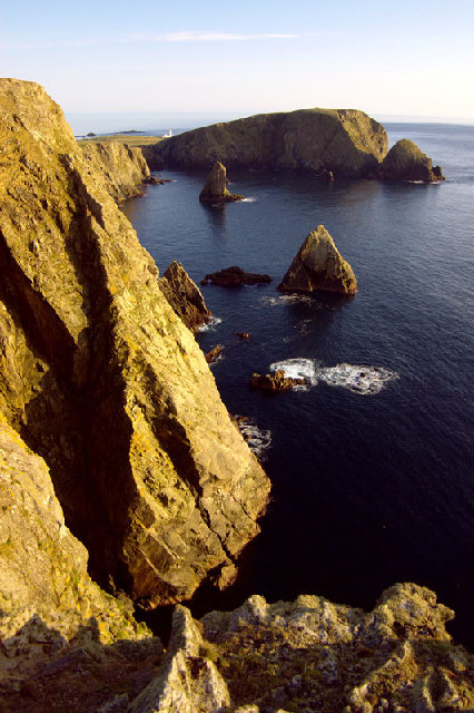
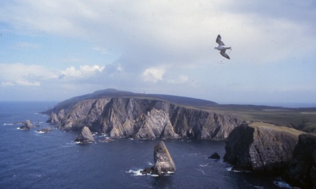
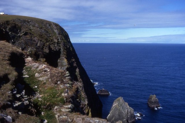
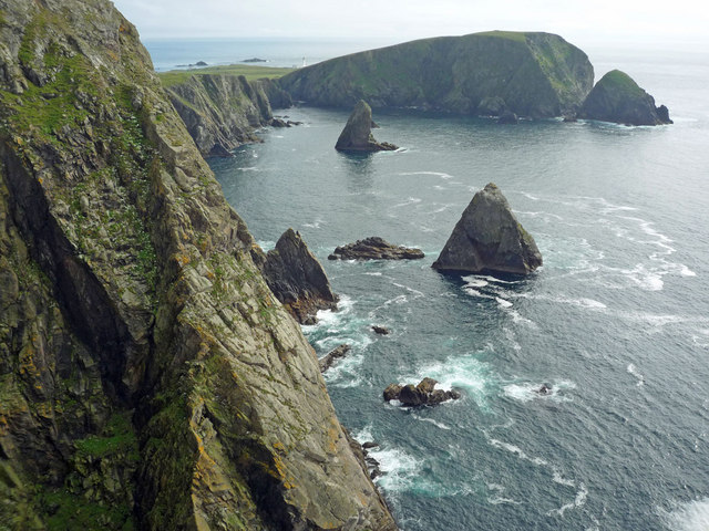
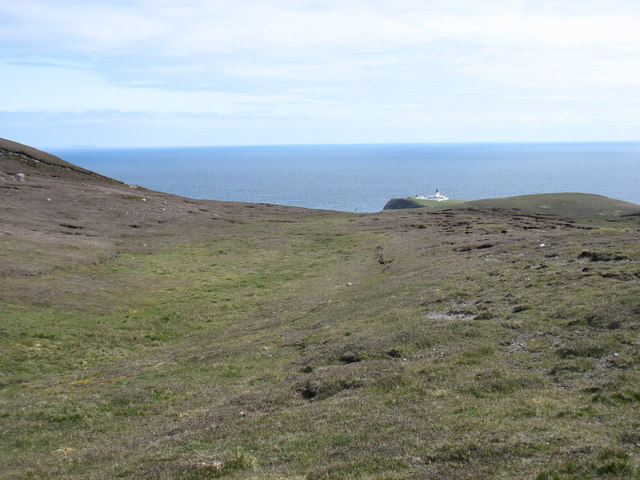
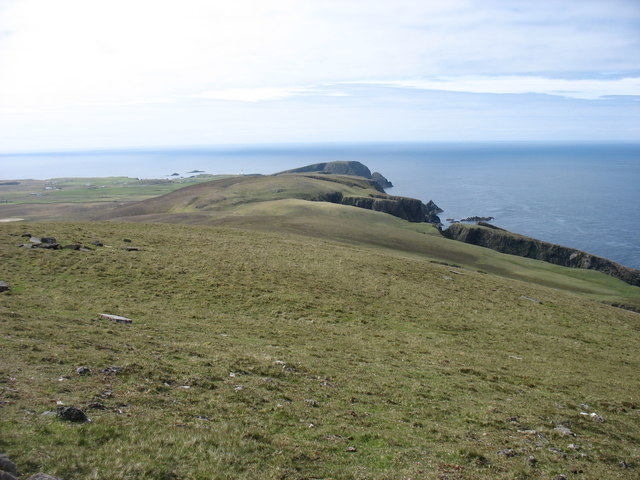
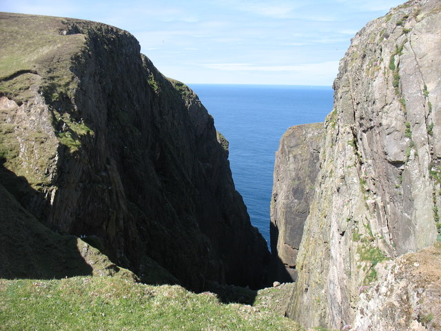
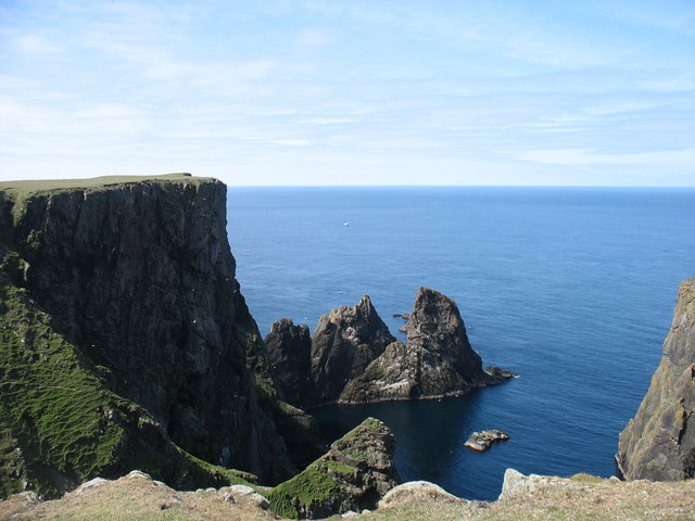
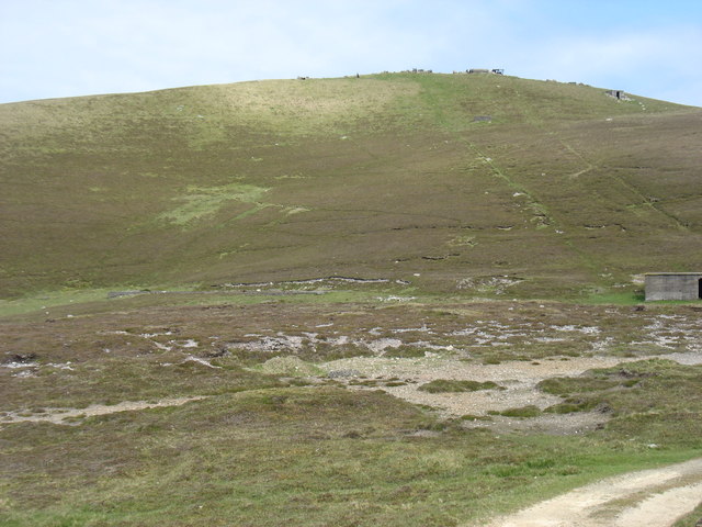
Sukka Moor is a small but picturesque area located in the Shetland Islands, Scotland. It is situated on the eastern side of the island of Shetland Mainland, near the village of Scalloway. This region is characterized by its rolling hills, vast open spaces, and unique moorland vegetation.

The moorland of Sukka Moor is mainly composed of heather, grasses, and scattered low-growing shrubs. This vegetation provides a rich habitat for various bird species, including red grouse, skylarks, and meadow pipits. The moorland is also home to a number of small mammals such as voles and shrews.

The landscape of Sukka Moor is dominated by undulating hills, which offer breathtaking panoramic views of the surrounding area. During the summer months, the moorland becomes covered in a vibrant carpet of purple heather, creating a stunning visual spectacle.

The area is popular among hikers and nature enthusiasts, who can explore the numerous walking trails that crisscross the moorland. These trails offer opportunities for visitors to immerse themselves in the natural beauty of the landscape while taking in the fresh air and tranquility.

Sukka Moor is also recognized for its historical significance, with several archaeological sites scattered throughout the area. These sites provide insights into the ancient human activity in the region, including the presence of settlements and burial grounds.

Overall, Sukka Moor is a captivating destination that offers visitors a chance to experience the rugged beauty of Shetland's moorland landscape, observe diverse wildlife, and explore the remnants of the area's rich history.

If you have any feedback on the listing, please let us know in the comments section below.

Sukka Moor Images

Images are sourced within 2km of 59.53488/-1.6331696 or Grid Reference HZ2072. Thanks to Geograph Open Source API. All images are credited.

Malcolm's Head At 107m, Malcolm's Head is the fifth highest hill on Fair Isle, after Ward Hill (217m), Burrashield Hill (150m), Sheep Rock (132m) and Vaasetter Hill (110m). Although one can argue about "What is a hill?", I do not think any other spot would really qualify, although there are many sea stacks.
Malcolm's Head
At 107m, Malcolm's Head is the fifth highest hill on Fair Isle, after Ward Hill (217m), Burrashield Hill (150m), Sheep Rock (132m) and Vaasetter Hill (110m). Although one can argue about "What is a hill?", I do not think any other spot would really qualify, although there are many sea stacks.
Malcolm's Head Malcolm's Head summit with distant view towards Fair Isle Lighthouse.  Sheep graze the slopes of this TuMP keeping the grass short.  Ruined war buildings near summit.
Name: Malcolm's Head
Hill number: 103899
Height: 107m / 351ft
Area: 22: Shetland Islands
Class: 1
Grid ref: HZ195707 (est)
Drop: 82m
Col: 25m
Malcolm's Head
Malcolm's Head summit with distant view towards Fair Isle Lighthouse. Sheep graze the slopes of this TuMP keeping the grass short. Ruined war buildings near summit. Name: Malcolm's Head Hill number: 103899 Height: 107m / 351ft Area: 22: Shetland Islands Class: 1 Grid ref: HZ195707 (est) Drop: 82m Col: 25m
Looking Over The Edge At Kista Fair Isle has a rugged coastline with numerous sea stacks which make for many a dramatic view.
Looking Over The Edge At Kista
Fair Isle has a rugged coastline with numerous sea stacks which make for many a dramatic view.
Malcolm's Head, Fair Isle, from the sea Taken from the ferry en route from Lerwick to Kirkwall, several km to the NW.
Malcolm's Head, Fair Isle, from the sea
Taken from the ferry en route from Lerwick to Kirkwall, several km to the NW.
The village and Sheep Rock from Malcolm's Head Tidy, well kept fields in the 'sheltered' centre of Fair Isle.
The village and Sheep Rock from Malcolm's Head
Tidy, well kept fields in the 'sheltered' centre of Fair Isle.
West cliffs, Fair Isle Looking southwest towards Malcolm's Head
West cliffs, Fair Isle
Looking southwest towards Malcolm's Head
Da Sherriff, Lunna Geo, Fair Isle The sea stack, da Sherriff, and Malcolm's Head beyond.
Da Sherriff, Lunna Geo, Fair Isle
The sea stack, da Sherriff, and Malcolm's Head beyond.
West cliffs of Fair Isle View north from Malcolm's Head along the west side of Fair Isle.
West cliffs of Fair Isle
View north from Malcolm's Head along the west side of Fair Isle.
Malcolm's Head A view along the cliffs on the north side of Malcolm's Head.
Malcolm's Head
A view along the cliffs on the north side of Malcolm's Head.
Coastline near Malcolm's Head A glorious clear day on Fair Isle with views over the crofting area.
Coastline near Malcolm's Head
A glorious clear day on Fair Isle with views over the crofting area.
Coastline from Malcolm's Head This is as near identical a viewpoint as I could find to <a href="https://www.geograph.org.uk/photo/871114">HZ1970 : Coastline near Malcolm's Head</a> which was taken in the summer of 1974. There are few differences to this view in 36 years, but they are significant for the island.  First, the wind turbine constructed in 1982 is evident - sadly in July 2010 it was not operating and needing repair.  Second, a community hall has been built beside the school - in the picture these are the nearest visible buildings to Sheep Rock. It is difficult to assess how much the coastline has eroded in the 36 years.
Coastline from Malcolm's Head
This is as near identical a viewpoint as I could find to HZ1970 : Coastline near Malcolm's Head which was taken in the summer of 1974. There are few differences to this view in 36 years, but they are significant for the island. First, the wind turbine constructed in 1982 is evident - sadly in July 2010 it was not operating and needing repair. Second, a community hall has been built beside the school - in the picture these are the nearest visible buildings to Sheep Rock. It is difficult to assess how much the coastline has eroded in the 36 years.
The cliffs at Kista View south to Malcolm's Head from the edge of Kista on a serene summer's day on Fair Isle.  An identical view taken in the Spring of 2005 is <a href="https://www.geograph.org.uk/photo/9395">HZ1971 : West cliffs, Fair Isle</a>.
The cliffs at Kista
View south to Malcolm's Head from the edge of Kista on a serene summer's day on Fair Isle. An identical view taken in the Spring of 2005 is HZ1971 : West cliffs, Fair Isle.
The north east of Fair Isle The North Light in the distance.
The north east of Fair Isle
The North Light in the distance.
Western Fair Isle Seen from near the summit of Ward Hill.
Western Fair Isle
Seen from near the summit of Ward Hill.
Troila Geo, Burrashield One of many Geos (steep inlets) on the west coast of Fair Isle.
Troila Geo, Burrashield
One of many Geos (steep inlets) on the west coast of Fair Isle.
Cliffs at Hoini, Fair Isle
The middle of the Fair Isle landing strip Flight DFL002 for Tingwall had just departed, and the next flight wasn't due to arrive for about six hours. So it was deemed quite safe for me to cross the strip on my way to the track to Ward Hill.

Amusingly, when that next flight arrived, the landing was aborted at the last minute, and the pilot went round for another attempt. The reason? There was a sheep on the strip!

The trip reminded me of my visit to the Isles of Scilly, at the other end of the country, in 2013. Similar small and rather noisy planes, and a runway (in <a href="https://www.geograph.org.uk/gridref/SV9110">SV9110</a>) on a convex slope so that the pilots couldn't see that far ahead.
The middle of the Fair Isle landing strip
Flight DFL002 for Tingwall had just departed, and the next flight wasn't due to arrive for about six hours. So it was deemed quite safe for me to cross the strip on my way to the track to Ward Hill. Amusingly, when that next flight arrived, the landing was aborted at the last minute, and the pilot went round for another attempt. The reason? There was a sheep on the strip! The trip reminded me of my visit to the Isles of Scilly, at the other end of the country, in 2013. Similar small and rather noisy planes, and a runway (in SV9110) on a convex slope so that the pilots couldn't see that far ahead.
Looking to Ward Hill, Fair Isle From near the transmission station. The two diagonal lines are clearly the routes of the cables used to haul goods up to the former radar station on the summit. What a shame that they weren't used to bring down some of the debris left on the summit after closure!

Although one can argue about "What is a hill?", I think there are five hills of any significance on Fair Isle. At 217m, Ward Hill is clearly the highest.
Looking to Ward Hill, Fair Isle
From near the transmission station. The two diagonal lines are clearly the routes of the cables used to haul goods up to the former radar station on the summit. What a shame that they weren't used to bring down some of the debris left on the summit after closure! Although one can argue about "What is a hill?", I think there are five hills of any significance on Fair Isle. At 217m, Ward Hill is clearly the highest.
Show me another place!

Sukka Moor is located at Grid Ref: HZ2072 (Lat: 59.53488, Lng: -1.6331696)

Unitary Authority: Shetland Islands

Police Authority: Highlands and Islands

What 3 Words

///linen.cling.grips. Near Sumburgh, Shetland Islands

Related Wikis

Fair Isle Airport

Fair Isle Airport (IATA: FIE, ICAO: EGEF), is a small airport located in Fair Isle, Shetland, Scotland. It is owned by the National Trust for Scotland...

Fair Isle

Fair Isle (; Scots: Fair Isle; Old Norse: Friðarey; Scottish Gaelic: Fara), sometimes Fairisle, is the southernmost Shetland island, situated roughly 38km...

North Haven (harbour)

North Haven is a natural cove, developed in the 20th century as one of the primary ports of Fair Isle, an outlying island of the Shetland Isles in the...

Stroms Hellier

Stroms Hellier (Stroms Heelor) is a steep-sided rocky cove located off the Swartz Geo inlet on Fair Isle in the Scottish Shetland Islands.On 27 September...

El Gran Grifón

El Gran Grifón was the flagship of the Spanish Armada's supply squadron of Baltic hulks (built in and chartered from the City of Rostock, in modern-day...

Black Watch (full-rigged ship)

Black Watch was a large full-rigged ship built by Windsor shipbuilder Bennett Smith in Windsor, Nova Scotia. It was the last ship built by Smith in Windsor...

Nearby Amenities

Located within 500m of 59.53488,-1.6331696
Aeroway: threshold
Ele: 69.2
Ref: 06
Source: Bing
Lat/Long: 59.5336056/-1.6321167
Aeroway: windsock
Source: Bing
Lat/Long: 59.5342052/-1.628377
Aeroway: threshold
Ele: 67.36
Ref: 24
Source: Bing
Lat/Long: 59.53585/-1.6249056
Toilets
Lat/Long: 59.5339983/-1.6287119
Waste Basket
Lat/Long: 59.534001/-1.6287613
Burrashield
Place: locality
Lat/Long: 59.5346544/-1.6408481
The data included in this document is from www.openstreetmap.org. The data is made available under ODbL.

Have you been to Sukka Moor?

Leave your review of Sukka Moor below (or comments, questions and feedback).