Burrista

Coastal Feature, Headland, Point in Shetland

Scotland

Burrista

Looking Over The Edge At Kista Fair Isle has a rugged coastline with numerous sea stacks which make for many a dramatic view.
Looking Over The Edge At Kista Credit: Rude Health

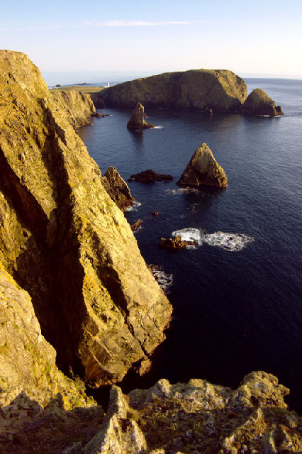
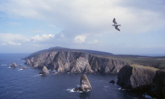
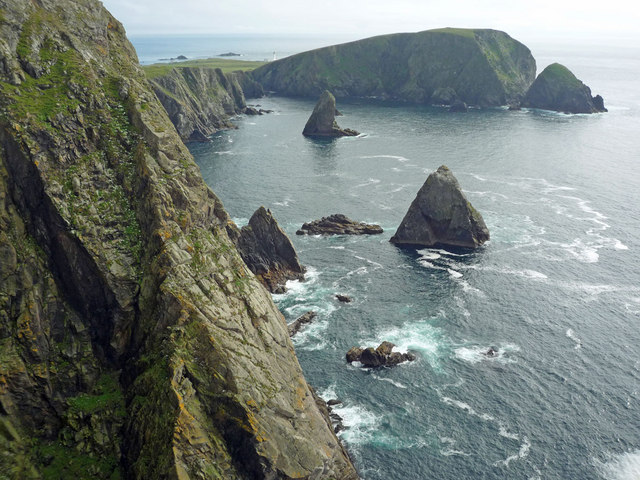
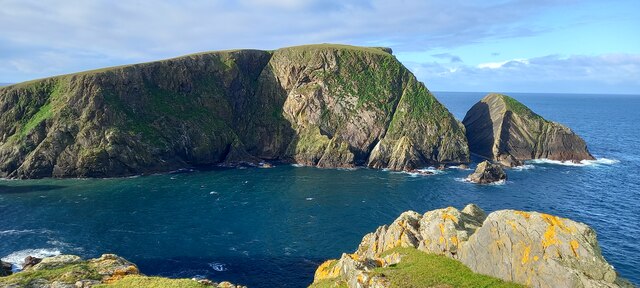
Burrista is a distinctive coastal feature located on the Shetland Islands in Scotland. Situated on the eastern coast of the main island, it is known for its prominent headland and picturesque point that juts out into the North Sea.

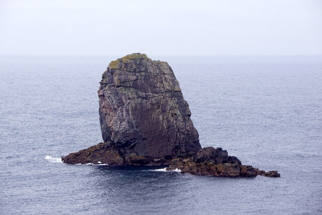
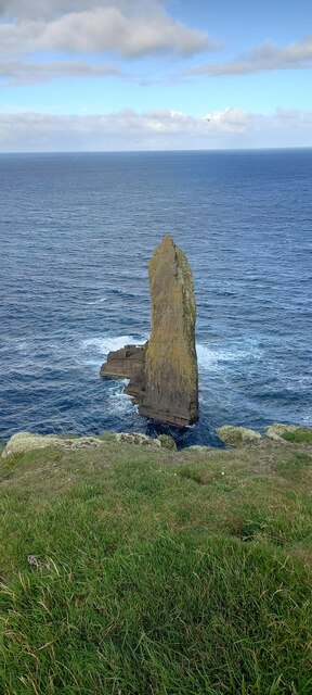
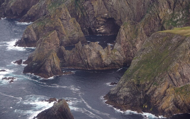
The headland of Burrista is characterized by its rugged cliffs, which rise steeply from the sea, offering breathtaking views of the surrounding landscape. These cliffs are mainly composed of sedimentary rocks, including sandstone and shale, which have been shaped and eroded by the relentless force of the ocean waves over thousands of years.

At the tip of Burrista is a striking point that serves as a natural landmark for sailors and fishermen navigating the treacherous waters of the North Sea. This point offers panoramic vistas of the coastline, with its jagged rocks and distant islands dotting the horizon.

The area around Burrista is home to a rich and diverse marine ecosystem, attracting a variety of seabirds and marine mammals. Visitors may catch a glimpse of puffins, guillemots, and even seals and dolphins as they explore the cliffs and waters surrounding the headland.

Burrista is also steeped in history, with ancient ruins and archaeological sites scattered throughout the surrounding landscape. These remnants offer glimpses into the lives of the people who once inhabited this area, providing valuable insights into the island's past.

Overall, Burrista is a captivating coastal feature that combines stunning natural beauty, diverse wildlife, and a rich historical heritage. It is a must-visit destination for nature enthusiasts, history lovers, and those seeking an escape into the rugged and awe-inspiring landscapes of the Shetland Islands.

If you have any feedback on the listing, please let us know in the comments section below.

Burrista Images

Images are sourced within 2km of 59.539563/-1.6445418 or Grid Reference HZ2072. Thanks to Geograph Open Source API. All images are credited.

Looking Over The Edge At Kista Fair Isle has a rugged coastline with numerous sea stacks which make for many a dramatic view.
Looking Over The Edge At Kista
Fair Isle has a rugged coastline with numerous sea stacks which make for many a dramatic view.
West cliffs, Fair Isle Looking southwest towards Malcolm's Head
West cliffs, Fair Isle
Looking southwest towards Malcolm's Head
Da Sherriff, Lunna Geo, Fair Isle The sea stack, da Sherriff, and Malcolm's Head beyond.
Da Sherriff, Lunna Geo, Fair Isle
The sea stack, da Sherriff, and Malcolm's Head beyond.
West cliffs of Fair Isle View north from Malcolm's Head along the west side of Fair Isle.
West cliffs of Fair Isle
View north from Malcolm's Head along the west side of Fair Isle.
Coastline near Malcolm's Head A glorious clear day on Fair Isle with views over the crofting area.
Coastline near Malcolm's Head
A glorious clear day on Fair Isle with views over the crofting area.
Coastline from Malcolm's Head This is as near identical a viewpoint as I could find to <a href="https://www.geograph.org.uk/photo/871114">HZ1970 : Coastline near Malcolm's Head</a> which was taken in the summer of 1974. There are few differences to this view in 36 years, but they are significant for the island.  First, the wind turbine constructed in 1982 is evident - sadly in July 2010 it was not operating and needing repair.  Second, a community hall has been built beside the school - in the picture these are the nearest visible buildings to Sheep Rock. It is difficult to assess how much the coastline has eroded in the 36 years.
Coastline from Malcolm's Head
This is as near identical a viewpoint as I could find to HZ1970 : Coastline near Malcolm's Head which was taken in the summer of 1974. There are few differences to this view in 36 years, but they are significant for the island. First, the wind turbine constructed in 1982 is evident - sadly in July 2010 it was not operating and needing repair. Second, a community hall has been built beside the school - in the picture these are the nearest visible buildings to Sheep Rock. It is difficult to assess how much the coastline has eroded in the 36 years.
The cliffs at Kista View south to Malcolm's Head from the edge of Kista on a serene summer's day on Fair Isle.  An identical view taken in the Spring of 2005 is <a href="https://www.geograph.org.uk/photo/9395">HZ1971 : West cliffs, Fair Isle</a>.
The cliffs at Kista
View south to Malcolm's Head from the edge of Kista on a serene summer's day on Fair Isle. An identical view taken in the Spring of 2005 is HZ1971 : West cliffs, Fair Isle.
The Sheriff and Malcolm's Head, Fair Isle
The Sherriff, Fair Isle
Swaabi Cole, Fair Isle
Fulmar (Fulmarus glacialis), Fair Isle
Fulmars (Fulmarus glacialis), Fair Isle
Malcolm's Head from the Raevas, Fair Isle
Lang Cole, Fair Isle
Fogli Stack, Fair Isle, from the air The sheer inner slope of the cliff fascinates me.
Fogli Stack, Fair Isle, from the air
The sheer inner slope of the cliff fascinates me.
Kista, Connis and the coast of Hoini, Fair Isle, from the air
Kista, Hoini, Fair Isle, from the air
Show me another place!

Burrista is located at Grid Ref: HZ2072 (Lat: 59.539563, Lng: -1.6445418)

Unitary Authority: Shetland Islands

Police Authority: Highlands and Islands

What 3 Words

///buying.relatives.lectured. Near Sumburgh, Shetland Islands

Related Wikis

Fair Isle Airport

Fair Isle Airport (IATA: FIE, ICAO: EGEF), is a small airport located in Fair Isle, Shetland, Scotland. It is owned by the National Trust for Scotland...

Fair Isle

Fair Isle (; Old Norse: FriĆ°arey; Scottish Gaelic: Fara), sometimes Fairisle, is the southernmost Shetland island, situated roughly 38 kilometres (20+1...

North Haven (harbour)

North Haven is a natural cove, developed in the 20th century as one of the primary ports of Fair Isle, an outlying island of the Shetland Isles in the...

Stroms Hellier

Stroms Hellier (Stroms Heelor) is a steep-sided rocky cove located off the Swartz Geo inlet on Fair Isle in the Scottish Shetland Islands. On 27 September...

Nearby Amenities

Located within 500m of 59.539563,-1.6445418
Lerness
Place: locality
Lat/Long: 59.5428239/-1.6411485
The data included in this document is from www.openstreetmap.org. The data is made available under ODbL.

Have you been to Burrista?

Leave your review of Burrista below (or comments, questions and feedback).