Geo of Grey

Coastal Feature, Headland, Point in Shetland

Scotland

Geo of Grey

Looking Over The Edge At Kista Fair Isle has a rugged coastline with numerous sea stacks which make for many a dramatic view.
Looking Over The Edge At Kista Credit: Rude Health

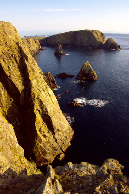
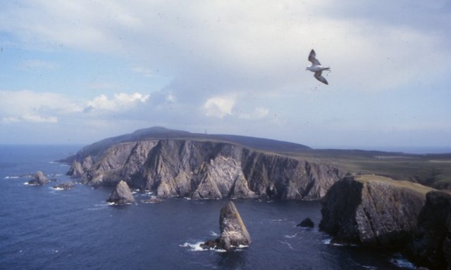
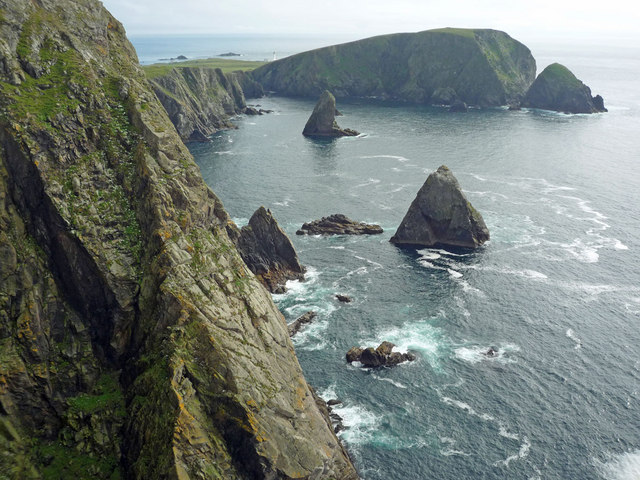
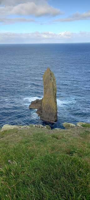
Geo of Grey is a prominent coastal feature located in the Shetland Islands, Scotland. It is a picturesque headland jutting out into the North Sea, forming a distinctive point along the coast. The name "Geo of Grey" is derived from the Old Norse word "Gjá" meaning a narrow or deep inlet, and "Grey" referring to the color of the rocks found in the area.

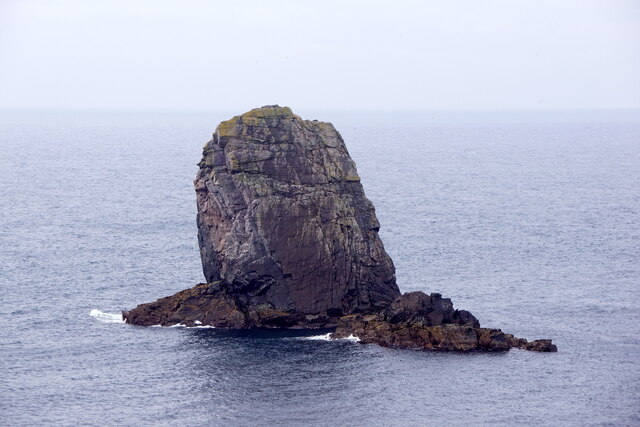
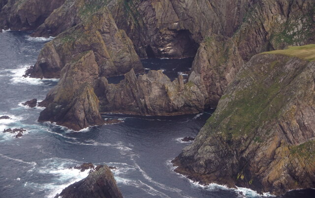
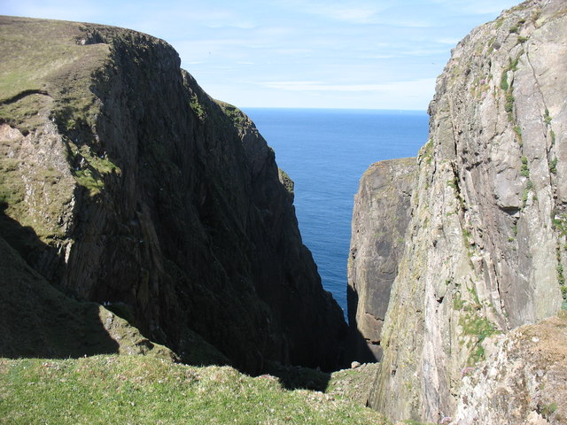
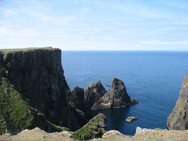
This headland is characterized by steep cliffs that rise dramatically from the sea, reaching heights of up to 100 meters. The cliffs are composed of ancient volcanic rocks, predominantly basalt and gabbro, which create a striking contrast against the deep blue waters of the North Sea. The geological formations at Geo of Grey are a result of ancient volcanic activity and subsequent erosion over millions of years.

The headland is known for its rugged beauty and is a popular spot for nature enthusiasts, geologists, and photographers. The cliffs provide nesting sites for various seabirds, including puffins, guillemots, and kittiwakes, making it a haven for birdwatchers.

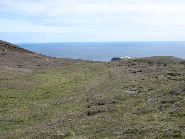
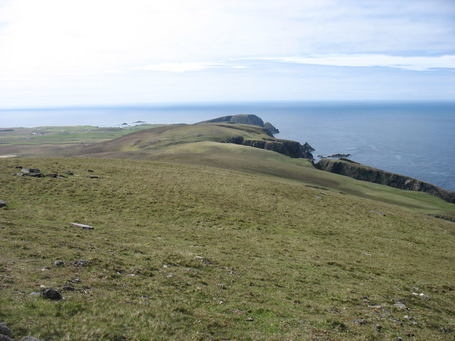
Visitors to Geo of Grey can enjoy breathtaking panoramic views of the surrounding coastline and the North Sea. The headland offers opportunities for coastal hikes along well-marked trails, allowing visitors to explore the diverse flora and fauna that thrive in this unique coastal environment.

Overall, Geo of Grey is a captivating coastal feature that showcases the geological wonders of the Shetland Islands. With its dramatic cliffs, diverse wildlife, and stunning views, it is a must-visit destination for nature lovers and those interested in the natural history of the region.

If you have any feedback on the listing, please let us know in the comments section below.

Geo of Grey Images

Images are sourced within 2km of 59.541498/-1.6429299 or Grid Reference HZ2072. Thanks to Geograph Open Source API. All images are credited.

Looking Over The Edge At Kista Fair Isle has a rugged coastline with numerous sea stacks which make for many a dramatic view.
Looking Over The Edge At Kista
Fair Isle has a rugged coastline with numerous sea stacks which make for many a dramatic view.
West cliffs, Fair Isle Looking southwest towards Malcolm's Head
West cliffs, Fair Isle
Looking southwest towards Malcolm's Head
West cliffs of Fair Isle View north from Malcolm's Head along the west side of Fair Isle.
West cliffs of Fair Isle
View north from Malcolm's Head along the west side of Fair Isle.
The cliffs at Kista View south to Malcolm's Head from the edge of Kista on a serene summer's day on Fair Isle.  An identical view taken in the Spring of 2005 is <a href="https://www.geograph.org.uk/photo/9395">HZ1971 : West cliffs, Fair Isle</a>.
The cliffs at Kista
View south to Malcolm's Head from the edge of Kista on a serene summer's day on Fair Isle. An identical view taken in the Spring of 2005 is HZ1971 : West cliffs, Fair Isle.
Swaabi Cole, Fair Isle
Fulmar (Fulmarus glacialis), Fair Isle
Fulmars (Fulmarus glacialis), Fair Isle
Lang Cole, Fair Isle
Kista, Connis and the coast of Hoini, Fair Isle, from the air
Kista, Hoini, Fair Isle, from the air
Hundi Stack and Swaabi Cole, Fair Isle, from the air
The north east of Fair Isle The North Light in the distance.
The north east of Fair Isle
The North Light in the distance.
Western Fair Isle Seen from near the summit of Ward Hill.
Western Fair Isle
Seen from near the summit of Ward Hill.
Troila Geo, Burrashield One of many Geos (steep inlets) on the west coast of Fair Isle.
Troila Geo, Burrashield
One of many Geos (steep inlets) on the west coast of Fair Isle.
Cliffs at Hoini, Fair Isle
The middle of the Fair Isle landing strip Flight DFL002 for Tingwall had just departed, and the next flight wasn't due to arrive for about six hours. So it was deemed quite safe for me to cross the strip on my way to the track to Ward Hill.

Amusingly, when that next flight arrived, the landing was aborted at the last minute, and the pilot went round for another attempt. The reason? There was a sheep on the strip!

The trip reminded me of my visit to the Isles of Scilly, at the other end of the country, in 2013. Similar small and rather noisy planes, and a runway (in <a href="https://www.geograph.org.uk/gridref/SV9110">SV9110</a>) on a convex slope so that the pilots couldn't see that far ahead.
The middle of the Fair Isle landing strip
Flight DFL002 for Tingwall had just departed, and the next flight wasn't due to arrive for about six hours. So it was deemed quite safe for me to cross the strip on my way to the track to Ward Hill. Amusingly, when that next flight arrived, the landing was aborted at the last minute, and the pilot went round for another attempt. The reason? There was a sheep on the strip! The trip reminded me of my visit to the Isles of Scilly, at the other end of the country, in 2013. Similar small and rather noisy planes, and a runway (in SV9110) on a convex slope so that the pilots couldn't see that far ahead.
Looking to Ward Hill, Fair Isle From near the transmission station. The two diagonal lines are clearly the routes of the cables used to haul goods up to the former radar station on the summit. What a shame that they weren't used to bring down some of the debris left on the summit after closure!

Although one can argue about "What is a hill?", I think there are five hills of any significance on Fair Isle. At 217m, Ward Hill is clearly the highest.
Looking to Ward Hill, Fair Isle
From near the transmission station. The two diagonal lines are clearly the routes of the cables used to haul goods up to the former radar station on the summit. What a shame that they weren't used to bring down some of the debris left on the summit after closure! Although one can argue about "What is a hill?", I think there are five hills of any significance on Fair Isle. At 217m, Ward Hill is clearly the highest.
Show me another place!

Geo of Grey is located at Grid Ref: HZ2072 (Lat: 59.541498, Lng: -1.6429299)

Unitary Authority: Shetland Islands

Police Authority: Highlands and Islands

What 3 Words

///sensitive.reckoned.unspoiled. Near Sumburgh, Shetland Islands

Related Wikis

Fair Isle Airport

Fair Isle Airport (IATA: FIE, ICAO: EGEF), is a small airport located in Fair Isle, Shetland, Scotland. It is owned by the National Trust for Scotland...

Fair Isle

Fair Isle (; Old Norse: Friðarey; Scottish Gaelic: Fara), sometimes Fairisle, is the southernmost Shetland island, situated roughly 38 kilometres (20+1...

North Haven (harbour)

North Haven is a natural cove, developed in the 20th century as one of the primary ports of Fair Isle, an outlying island of the Shetland Isles in the...

Stroms Hellier

Stroms Hellier (Stroms Heelor) is a steep-sided rocky cove located off the Swartz Geo inlet on Fair Isle in the Scottish Shetland Islands. On 27 September...

Nearby Amenities

Located within 500m of 59.541498,-1.6429299
Lerness
Place: locality
Lat/Long: 59.5428239/-1.6411485
The data included in this document is from www.openstreetmap.org. The data is made available under ODbL.

Have you been to Geo of Grey?

Leave your review of Geo of Grey below (or comments, questions and feedback).