Breiti Stack

Island in Shetland

Scotland

Breiti Stack

Malcolm's Head At 107m, Malcolm's Head is the fifth highest hill on Fair Isle, after Ward Hill (217m), Burrashield Hill (150m), Sheep Rock (132m) and Vaasetter Hill (110m). Although one can argue about "What is a hill?", I do not think any other spot would really qualify, although there are many sea stacks.
Malcolm's Head Credit: David Purchase

Breiði Stack is a small uninhabited island located in the Shetland archipelago, off the northeast coast of Scotland. It lies approximately 8 miles west of the island of Papa Stour and is part of the ward of West Side in the Shetland Islands Council area.

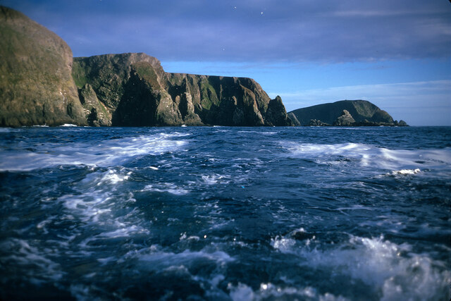
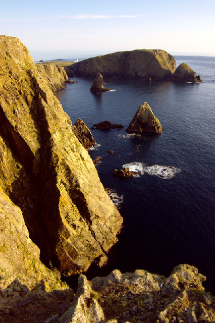
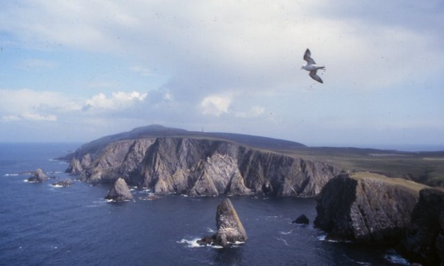
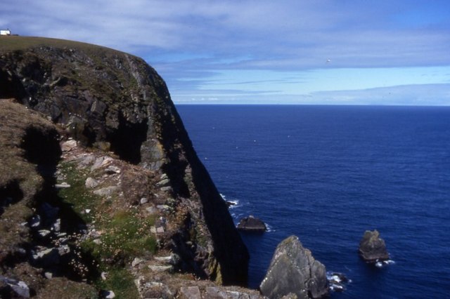
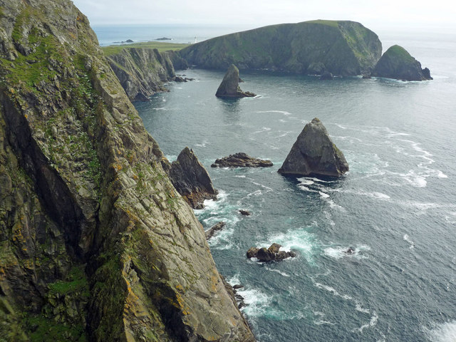
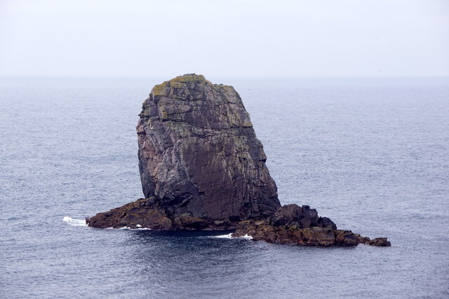
The island is renowned for its distinctive rock stack, which stands at an impressive height of around 70 meters, making it a popular destination for birdwatchers and nature enthusiasts. Breiði Stack is home to a variety of seabirds, including fulmars, guillemots, razorbills, and puffins, which nest on the cliffs and provide a mesmerizing spectacle during the breeding season.

The island itself is relatively small, measuring just over 1 kilometer in length and encompassing an area of around 15 hectares. Its rugged coastline is dotted with sea caves and crevices, adding to its charm and appeal to adventurous visitors.

Breiði Stack's isolation and lack of facilities make it an ideal spot for those seeking tranquility and a true wilderness experience. The absence of human habitation allows the natural beauty of the island to take center stage, offering a serene retreat for those looking to connect with nature.

Access to Breiði Stack is primarily by boat, with several local tour operators offering guided trips to the island. Visitors are advised to check weather conditions and plan their trip accordingly, as the unpredictable nature of the North Atlantic can sometimes make access difficult.

Overall, Breiði Stack is a haven for wildlife and a picturesque gem in the Shetland archipelago, providing a unique opportunity to experience the raw beauty of Scotland's coastal landscape.

If you have any feedback on the listing, please let us know in the comments section below.

Breiti Stack Images

Images are sourced within 2km of 59.537978/-1.6460615 or Grid Reference HZ2072. Thanks to Geograph Open Source API. All images are credited.

Malcolm's Head At 107m, Malcolm's Head is the fifth highest hill on Fair Isle, after Ward Hill (217m), Burrashield Hill (150m), Sheep Rock (132m) and Vaasetter Hill (110m). Although one can argue about "What is a hill?", I do not think any other spot would really qualify, although there are many sea stacks.
Malcolm's Head
At 107m, Malcolm's Head is the fifth highest hill on Fair Isle, after Ward Hill (217m), Burrashield Hill (150m), Sheep Rock (132m) and Vaasetter Hill (110m). Although one can argue about "What is a hill?", I do not think any other spot would really qualify, although there are many sea stacks.
West coast of Fair Isle, looking back to Malcolm's Head The image position is uncertain.  Malcolm's Head is the headland  in the distance.  The west coast of Fair Isle sports some great cliff and geo scenery.
West coast of Fair Isle, looking back to Malcolm's Head
The image position is uncertain. Malcolm's Head is the headland in the distance. The west coast of Fair Isle sports some great cliff and geo scenery.
Malcolm's Head Malcolm's Head summit with distant view towards Fair Isle Lighthouse.  Sheep graze the slopes of this TuMP keeping the grass short.  Ruined war buildings near summit.
Name: Malcolm's Head
Hill number: 103899
Height: 107m / 351ft
Area: 22: Shetland Islands
Class: 1
Grid ref: HZ195707 (est)
Drop: 82m
Col: 25m
Malcolm's Head
Malcolm's Head summit with distant view towards Fair Isle Lighthouse. Sheep graze the slopes of this TuMP keeping the grass short. Ruined war buildings near summit. Name: Malcolm's Head Hill number: 103899 Height: 107m / 351ft Area: 22: Shetland Islands Class: 1 Grid ref: HZ195707 (est) Drop: 82m Col: 25m
Looking Over The Edge At Kista Fair Isle has a rugged coastline with numerous sea stacks which make for many a dramatic view.
Looking Over The Edge At Kista
Fair Isle has a rugged coastline with numerous sea stacks which make for many a dramatic view.
Malcolm's Head, Fair Isle, from the sea Taken from the ferry en route from Lerwick to Kirkwall, several km to the NW.
Malcolm's Head, Fair Isle, from the sea
Taken from the ferry en route from Lerwick to Kirkwall, several km to the NW.
West cliffs, Fair Isle Looking southwest towards Malcolm's Head
West cliffs, Fair Isle
Looking southwest towards Malcolm's Head
Da Sherriff, Lunna Geo, Fair Isle The sea stack, da Sherriff, and Malcolm's Head beyond.
Da Sherriff, Lunna Geo, Fair Isle
The sea stack, da Sherriff, and Malcolm's Head beyond.
West cliffs of Fair Isle View north from Malcolm's Head along the west side of Fair Isle.
West cliffs of Fair Isle
View north from Malcolm's Head along the west side of Fair Isle.
Malcolm's Head A view along the cliffs on the north side of Malcolm's Head.
Malcolm's Head
A view along the cliffs on the north side of Malcolm's Head.
Malcolm's Head from the west From the Shetland-Orkney ferry.
Malcolm's Head from the west
From the Shetland-Orkney ferry.
Coastline near Malcolm's Head A glorious clear day on Fair Isle with views over the crofting area.
Coastline near Malcolm's Head
A glorious clear day on Fair Isle with views over the crofting area.
Coastline from Malcolm's Head This is as near identical a viewpoint as I could find to <a href="https://www.geograph.org.uk/photo/871114">HZ1970 : Coastline near Malcolm's Head</a> which was taken in the summer of 1974. There are few differences to this view in 36 years, but they are significant for the island.  First, the wind turbine constructed in 1982 is evident - sadly in July 2010 it was not operating and needing repair.  Second, a community hall has been built beside the school - in the picture these are the nearest visible buildings to Sheep Rock. It is difficult to assess how much the coastline has eroded in the 36 years.
Coastline from Malcolm's Head
This is as near identical a viewpoint as I could find to HZ1970 : Coastline near Malcolm's Head which was taken in the summer of 1974. There are few differences to this view in 36 years, but they are significant for the island. First, the wind turbine constructed in 1982 is evident - sadly in July 2010 it was not operating and needing repair. Second, a community hall has been built beside the school - in the picture these are the nearest visible buildings to Sheep Rock. It is difficult to assess how much the coastline has eroded in the 36 years.
The cliffs at Kista View south to Malcolm's Head from the edge of Kista on a serene summer's day on Fair Isle.  An identical view taken in the Spring of 2005 is <a href="https://www.geograph.org.uk/photo/9395">HZ1971 : West cliffs, Fair Isle</a>.
The cliffs at Kista
View south to Malcolm's Head from the edge of Kista on a serene summer's day on Fair Isle. An identical view taken in the Spring of 2005 is HZ1971 : West cliffs, Fair Isle.
The Sheriff and Malcolm's Head, Fair Isle
Malcolm's Head, Fair Isle, from the air
The Sherriff, Fair Isle
Swaabi Cole, Fair Isle
Show me another place!

Breiti Stack is located at Grid Ref: HZ2072 (Lat: 59.537978, Lng: -1.6460615)

Unitary Authority: Shetland Islands

Police Authority: Highlands and Islands

What 3 Words

///muddy.remaking.supply. Near Sumburgh, Shetland Islands

Related Wikis

Fair Isle Airport

Fair Isle Airport (IATA: FIE, ICAO: EGEF), is a small airport located in Fair Isle, Shetland, Scotland. It is owned by the National Trust for Scotland...

Fair Isle

Fair Isle (; Old Norse: Friðarey; Scottish Gaelic: Fara), sometimes Fairisle, is the southernmost Shetland island, situated roughly 38 kilometres (20+1...

North Haven (harbour)

North Haven is a natural cove, developed in the 20th century as one of the primary ports of Fair Isle, an outlying island of the Shetland Isles in the...

Stroms Hellier

Stroms Hellier (Stroms Heelor) is a steep-sided rocky cove located off the Swartz Geo inlet on Fair Isle in the Scottish Shetland Islands. On 27 September...

Nearby Amenities

Located within 500m of 59.537978,-1.6460615
Burrashield
Place: locality
Lat/Long: 59.5346544/-1.6408481
The data included in this document is from www.openstreetmap.org. The data is made available under ODbL.

Have you been to Breiti Stack?

Leave your review of Breiti Stack below (or comments, questions and feedback).