Carletonhall Park

Downs, Moorland in Cumberland Eden

England

Carletonhall Park

Brougham Castle The castle is situated in the south to southeastern corner of the grid square, southwest of Penrith in Cumbria. The picture was taken looking eastwards towards the castle from the road.
Brougham Castle Credit: Pam Brophy

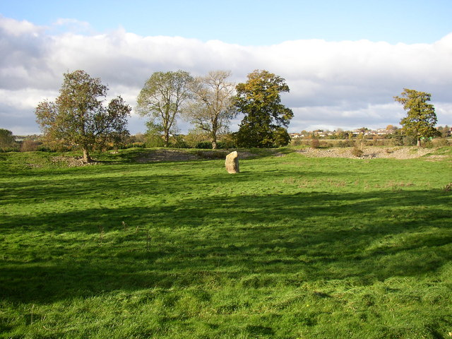
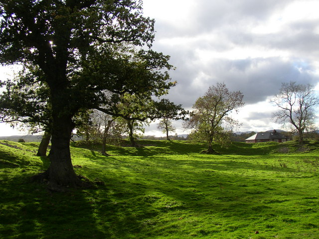
Carletonhall Park is a picturesque green expanse located in Cumberland, England. Situated between the towns of Carlisle and Brampton, this park encompasses a vast area of downs, moorland, and rolling hills that offer breathtaking views of the surrounding countryside.

The park is famous for its diverse wildlife and natural beauty. It is home to a wide range of plant and animal species, including rare birds, such as the red grouse and the curlew, which are often spotted by birdwatchers. The moorland is covered in heather and grasses, creating a stunning purple and green landscape that changes with the seasons.

Carletonhall Park is a popular destination for outdoor enthusiasts and nature lovers. It offers numerous walking trails that meander through the park, allowing visitors to explore its varied terrain at their own pace. The downs provide ample space for picnics and family gatherings, with well-maintained grassy areas and designated barbecue spots.

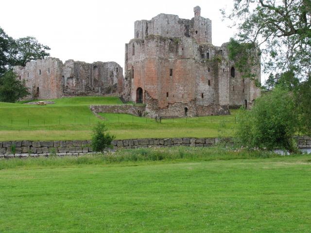
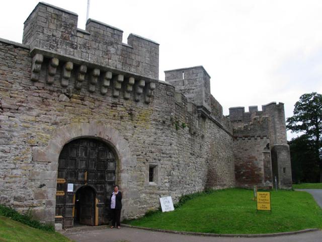
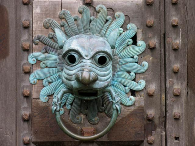
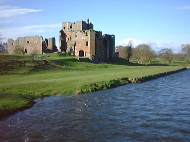
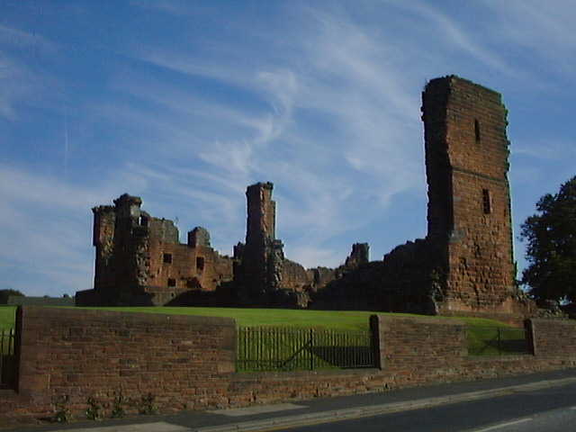
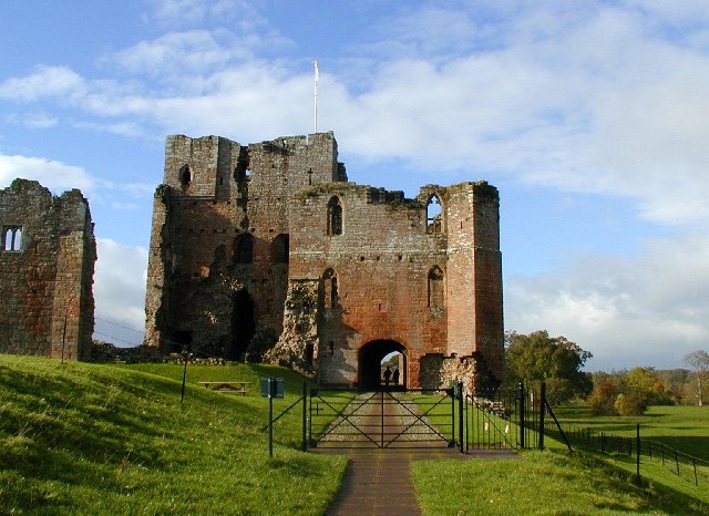
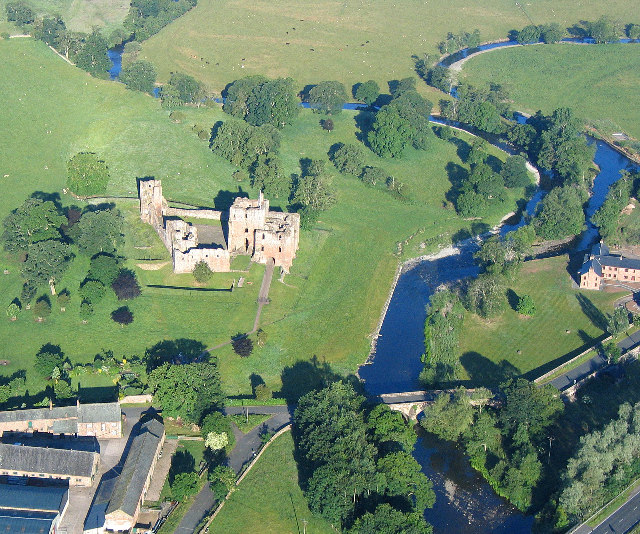
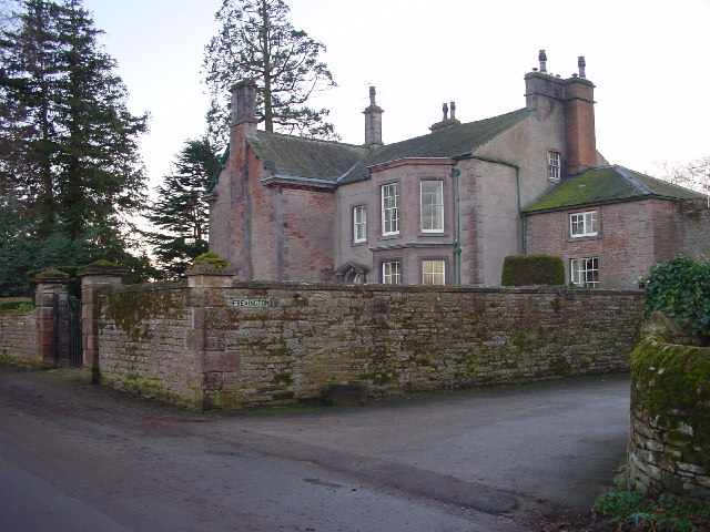
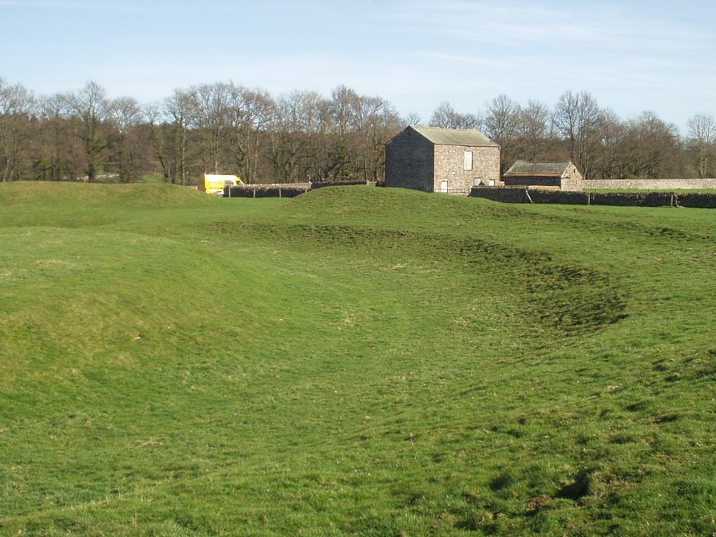
The park also boasts historical significance. The ruins of Carleton Hall, a 14th-century fortified manor house, can be found within its grounds. These ruins serve as a reminder of the park's rich past and offer a glimpse into the region's medieval history.

Overall, Carletonhall Park is a haven of natural beauty and tranquility in the heart of Cumberland. Its diverse landscapes, wildlife, and historical features make it a must-visit destination for those seeking an escape from the hustle and bustle of city life.

If you have any feedback on the listing, please let us know in the comments section below.

Carletonhall Park Images

Images are sourced within 2km of 54.653789/-2.735358 or Grid Reference NY5228. Thanks to Geograph Open Source API. All images are credited.

Brougham Castle The castle is situated in the south to southeastern corner of the grid square, southwest of Penrith in Cumbria. The picture was taken looking eastwards towards the castle from the road.
Brougham Castle
The castle is situated in the south to southeastern corner of the grid square, southwest of Penrith in Cumbria. The picture was taken looking eastwards towards the castle from the road.
Brougham Hall This Manor House situated in the south eastern corner of the square, has seen all sorts of troubled times. It is now a craft centre and produces delicious smoked cheese.
Brougham Hall
This Manor House situated in the south eastern corner of the square, has seen all sorts of troubled times. It is now a craft centre and produces delicious smoked cheese.
One of a pair This photograph of the knocker on the door at Brougham Hall, is submitted as a supplementary photo, as it is of some interest. Its partner is to be found on the door of Durham Cathedral <a title="https://www.geograph.org.uk/photo/2532705" href="https://www.geograph.org.uk/photo/2532705">Link</a>.
One of a pair
This photograph of the knocker on the door at Brougham Hall, is submitted as a supplementary photo, as it is of some interest. Its partner is to be found on the door of Durham Cathedral Link.
Honeysuckle Cottage Visitor Centre This is a photograph of the visitors' centre for Lilliput Lane Miniature Cottages. The exact grid reference is NY510288.
Honeysuckle Cottage Visitor Centre
This is a photograph of the visitors' centre for Lilliput Lane Miniature Cottages. The exact grid reference is NY510288.
Brougham Castle This ancient castle which was home to Lady Anne Clifford. Open to the public under the care of English Heritage.
Brougham Castle
This ancient castle which was home to Lady Anne Clifford. Open to the public under the care of English Heritage.
Penrith Castle Penrith Castle freely open to the public. Located across the road from the railway station so worth a browse whilst you await a train
Penrith Castle
Penrith Castle freely open to the public. Located across the road from the railway station so worth a browse whilst you await a train
Brougham Castle near Penrith Photo shows the double gatehouse - started in the 13th century based on a roman fort.
Brougham Castle near Penrith
Photo shows the double gatehouse - started in the 13th century based on a roman fort.
Clifton Hall Pele, near Penrith, Cumbria Built in late 16th century
<span class="nowrap"><a title="www.visitcumbria.com/pen/clifthal.htm" rel="nofollow ugc noopener" href="http://www.visitcumbria.com/pen/clifthal.htm">Link</a><img style="margin-left:2px;" alt="External link" title="External link - shift click to open in new window" src="https://s1.geograph.org.uk/img/external.png" width="10" height="10"/></span>
Clifton Hall Pele, near Penrith, Cumbria
Built in late 16th century LinkExternal link
River Eamont at Brougham Castle, Cumbria This view shows the waters of the River Eamont and River Lowther meeting at Brougham Castle. <span class="nowrap"><a title="http://www.visitcumbria.com/pen/brougham.htm" rel="nofollow ugc noopener" href="http://www.visitcumbria.com/pen/brougham.htm">Link</a><img style="margin-left:2px;" alt="External link" title="External link - shift click to open in new window" src="https://s1.geograph.org.uk/img/external.png" width="10" height="10"/></span>
River Eamont at Brougham Castle, Cumbria
This view shows the waters of the River Eamont and River Lowther meeting at Brougham Castle. LinkExternal link
Penrith Railway Station, August 1974 Nearly new electric loco 87030 passes through on an express to Euston
Penrith Railway Station, August 1974
Nearly new electric loco 87030 passes through on an express to Euston
A6 to Cliburn Junction.
Evening Grazing Taken from Fremington, looking east towards the Pennines. The two power lines provide a contrast to the rural scene.
Evening Grazing
Taken from Fremington, looking east towards the Pennines. The two power lines provide a contrast to the rural scene.
Fremington House A large, imposing sandstone house.
Fremington House
A large, imposing sandstone house.
Penrith Railway Station warning (the boring, real version) For the more imaginative, less real version have a look at the following picture, for which I have no copyright or ownership, nor any info regarding the wag responsible . . . 
<span class="nowrap"><a title="http://www.bimmerfest.com/photos/data/500/theplacetobe.jpg" rel="nofollow ugc noopener" href="http://www.bimmerfest.com/photos/data/500/theplacetobe.jpg">Link</a><img style="margin-left:2px;" alt="External link" title="External link - shift click to open in new window" src="https://s1.geograph.org.uk/img/external.png" width="10" height="10"/></span>
Penrith Railway Station warning (the boring, real version)
For the more imaginative, less real version have a look at the following picture, for which I have no copyright or ownership, nor any info regarding the wag responsible . . . LinkExternal link
Carleton Hall. Cumbria constabulary headquarters at the moment.
Carleton Hall.
Cumbria constabulary headquarters at the moment.
Mayburgh Henge, northern part with standing-stone, Yanwath and Eamont Bridge Mayburgh Henge consists of a single circular bank, up to 6.5 metres high, and 50m across its base, with a single entrance and enclosing a level area 90m dia. It contains a single monolith 2.8m high, one of eight that existed in the 18C, four in the centre and four at the entrance. The other seven were destroyed using gunpowder.  The henge probably dates from between 2000 and 1000BC, and may have been a meeting place or refuge for a large prehistoric community.
Mayburgh Henge, northern part with standing-stone, Yanwath and Eamont Bridge
Mayburgh Henge consists of a single circular bank, up to 6.5 metres high, and 50m across its base, with a single entrance and enclosing a level area 90m dia. It contains a single monolith 2.8m high, one of eight that existed in the 18C, four in the centre and four at the entrance. The other seven were destroyed using gunpowder. The henge probably dates from between 2000 and 1000BC, and may have been a meeting place or refuge for a large prehistoric community.
Mayburgh Henge, south-western part, Yanwath and Eamont Bridge A quick search on the internet will produce several other photographs, including aerial views.
Mayburgh Henge, south-western part, Yanwath and Eamont Bridge
A quick search on the internet will produce several other photographs, including aerial views.
The Eden Millennium Monument, Yanwath and Eamont Bridge This 50t block of granite was transported here and erected on 2 July 2000.  It is inscribed with an alpha and an omega, the first and last letters of the Greek alphabet signifying beginning and end, past and future. It is also inscribed with a cross and '2000' for 2000 years of Christianity. The site was chosen because of its proximity to Mayburgh Henge.
The Eden Millennium Monument, Yanwath and Eamont Bridge
This 50t block of granite was transported here and erected on 2 July 2000. It is inscribed with an alpha and an omega, the first and last letters of the Greek alphabet signifying beginning and end, past and future. It is also inscribed with a cross and '2000' for 2000 years of Christianity. The site was chosen because of its proximity to Mayburgh Henge.
Show me another place!

Carletonhall Park is located at Grid Ref: NY5228 (Lat: 54.653789, Lng: -2.735358)

Administrative County: Cumbria

District: Eden

Police Authority: Cumbria

What 3 Words

///lawful.initiated.necks. Near Penrith, Cumbria

Related Wikis

Eamont Bridge (structure)

Eamont Bridge is a road bridge over the River Eamont, at the village of the same name, immediately to the south of Penrith, Cumbria, England. It is a scheduled...

Brougham Hall

Brougham Hall is a historic house museum located in the village of Brougham just outside Penrith, Cumbria, England. == History == The de Burgham family...

King Arthur's Round Table

King Arthur's Round Table is a Neolithic henge in the village of Eamont Bridge in the English county of Cumbria, around 2 kilometres (1 mi) south east...

Carleton, Penrith

Carleton is a suburb of the town of Penrith, Cumbria, England, that has seen a huge growth in housing since the 1960s and is, of 2018, still expanding...

Nearby Amenities

Located within 500m of 54.653789,-2.735358
Source: survey
Lat/Long: 54.6553046/-2.7419743
Source: survey
Lat/Long: 54.6547542/-2.7414434
Note: Junction name "Kemplay Bank"
Lat/Long: 54.6568028/-2.736816
Traffic Signals
Lat/Long: 54.6518134/-2.7421412
Barrier: stile
Lat/Long: 54.6520527/-2.7391259
Barrier: stile
Lat/Long: 54.6521877/-2.7391674
Traffic Signals
Source: survey
Lat/Long: 54.6554969/-2.7421847
Crossing
Crossing: unmarked
Crossing Island: yes
Crossing Markings: no
Kerb: flush
Tactile Paving: yes
Lat/Long: 54.6552501/-2.7413936
Traffic Signals
Lat/Long: 54.6550187/-2.7415116
Traffic Signals
Source: survey
Lat/Long: 54.6553475/-2.7423122
Crossing
Bicycle: yes
Crossing: unmarked
Crossing Island: yes
Crossing Markings: no
Crossing Signals: yes
Crossing Ref: toucan
Source: survey
Tactile Paving: yes
Lat/Long: 54.6549588/-2.7412247
Carleton Hall Park
Place: locality
Lat/Long: 54.6548074/-2.7355229
Westmorland Holme
Place: locality
Lat/Long: 54.6558073/-2.7289284
Crossing
Bicycle: yes
Crossing: unmarked
Crossing Markings: no
Crossing Signals: yes
Crossing Ref: toucan
Kerb: lowered
Tactile Paving: yes
Lat/Long: 54.6541506/-2.7426244
Crossing
Bicycle: yes
Crossing: unmarked
Crossing Island: yes
Crossing Markings: no
Crossing Signals: yes
Crossing Ref: toucan
Source: survey
Tactile Paving: yes
Lat/Long: 54.6549905/-2.7414931
Crossing
Crossing: unmarked
Crossing Island: yes
Crossing Markings: no
Tactile Paving: yes
Lat/Long: 54.6540563/-2.7422323
Traffic Signals
Source: survey
Lat/Long: 54.6541593/-2.7425482
Traffic Signals
Source: survey
Lat/Long: 54.6539936/-2.7426754
Waterway: weir
Lat/Long: 54.6517091/-2.7390365
Crossing
Crossing: unmarked
Crossing Markings: no
Lat/Long: 54.6575007/-2.7364887
Crossing
Crossing: unmarked
Crossing Markings: no
Lat/Long: 54.6582054/-2.7344408
Crossing
Crossing: marked
Crossing Markings: yes
Traffic Calming: table
Lat/Long: 54.6556432/-2.7375865
Crossing
Crossing: unmarked
Crossing Island: no
Crossing Markings: no
Tactile Paving: no
Lat/Long: 54.65439/-2.7416052
Generator Method: photovoltaic
Generator Output Electricity: yes
Generator Source: solar
Generator Type: solar_photovoltaic_panel
Location: roof
Power: generator
Lat/Long: 54.6578/-2.7366352
Direction: 220
Man Made: surveillance
Surveillance: public
Surveillance Type: ALPR
Surveillance Zone: traffic
Lat/Long: 54.6559303/-2.7418693
Direction: 75
Man Made: surveillance
Surveillance: public
Surveillance Type: ALPR
Surveillance Zone: traffic
Lat/Long: 54.6559324/-2.7418648
Crossing
Bicycle: yes
Crossing: unmarked
Crossing Island: yes
Crossing Markings: no
Crossing Signals: yes
Crossing Ref: toucan
Tactile Paving: yes
Lat/Long: 54.6540228/-2.7427353
Crossing
Bicycle: yes
Crossing: unmarked
Crossing Island: yes
Crossing Markings: no
Crossing Signals: yes
Crossing Ref: toucan
Tactile Paving: yes
Lat/Long: 54.6554596/-2.7421575
Crossing
Bicycle: yes
Crossing: unmarked
Crossing Island: yes
Crossing Markings: no
Crossing Signals: yes
Crossing Ref: toucan
Tactile Paving: yes
Lat/Long: 54.6555755/-2.7423663
Traffic Signals
Lat/Long: 54.6549784/-2.7411965
Cumbria Fire and Rescue Service
Government: fire_service
Office: government
Website: https://www.cumbriafire.gov.uk/
Wikidata: Q5194033
Wikipedia: en:Cumbria Fire and Rescue Service
Lat/Long: 54.6543683/-2.7408997
The data included in this document is from www.openstreetmap.org. The data is made available under ODbL.

Have you been to Carletonhall Park?

Leave your review of Carletonhall Park below (or comments, questions and feedback).