Kenneggy Cliff

Cliff, Slope in Cornwall

England

Kenneggy Cliff

Views out to sea from PROW
Views out to sea from PROW Credit: thejackrustles

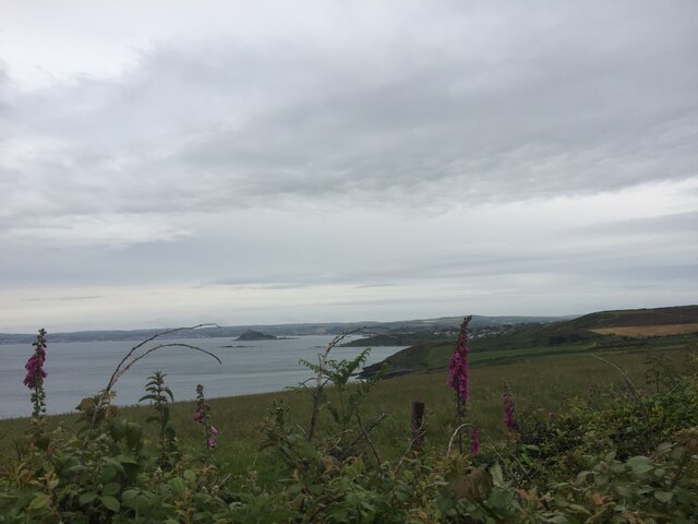
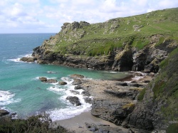
Kenneggy Cliff is a stunning geological formation located in Cornwall, England. It is situated on the southern coast, near the village of Rosudgeon, and overlooks the Celtic Sea. This magnificent cliff stands at an impressive height of about 60 meters, offering breathtaking panoramic views of the surrounding landscape.

The cliff is composed of rugged granite rocks, which have been shaped and carved by the relentless forces of nature over millions of years. Its distinctive jagged appearance is a result of erosion caused by the crashing waves and strong winds that batter the coast.

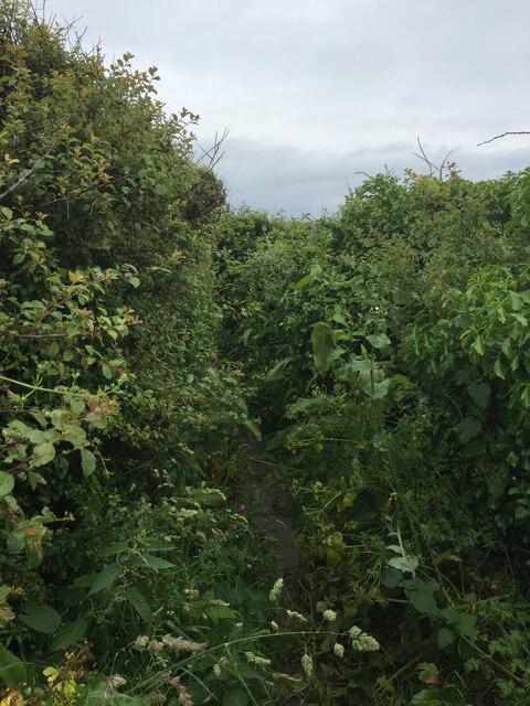
At the base of Kenneggy Cliff, there is a narrow, pebbly beach, which can be accessed via a steep and winding footpath. This secluded beach is a haven for nature lovers, offering a peaceful and tranquil spot to relax and enjoy the sound of the crashing waves.

The area surrounding Kenneggy Cliff is rich in flora and fauna, making it a popular destination for hikers and nature enthusiasts. The cliff is home to various species of seabirds, including gulls and cormorants, which can often be seen nesting on the rocky ledges.

Visitors to Kenneggy Cliff can also explore the nearby ancient remains of the Tregiffian Burial Chamber, a Neolithic tomb dating back over 5,000 years. This historic site provides a fascinating glimpse into the region's rich cultural heritage.

Overall, Kenneggy Cliff is a captivating natural wonder, offering visitors a chance to experience the raw beauty of Cornwall's coastline and immerse themselves in its rich history.

If you have any feedback on the listing, please let us know in the comments section below.

Kenneggy Cliff Images

Images are sourced within 2km of 50.104389/-5.4081292 or Grid Reference SW5628. Thanks to Geograph Open Source API. All images are credited.

Views out to sea from PROW
Very overgrown footpath
Lovely coastline
Lovely coastline
Cudden Point Trig Point Flush Bracket S8075 <span class="nowrap"><a title="http://trigpointing.uk/trig/2667" rel="nofollow ugc noopener" href="http://trigpointing.uk/trig/2667">Link</a><img style="margin-left:2px;" alt="External link" title="External link - shift click to open in new window" src="https://s1.geograph.org.uk/img/external.png" width="10" height="10"/></span>
Cudden Point Trig Point Flush Bracket S8075
Coastal views
Coastal views
Prussia Cove
Prussia Cove
Looking down on Kenneggy Sand
Looking along Kenneggy Cliff  From the old mine.
Looking along Kenneggy Cliff
From the old mine.
The old mine above Kenneggy Sand
The footpath near the old mine
Farm tracks and footpaths A complicated junction on the way to the Coast Path.
Farm tracks and footpaths
A complicated junction on the way to the Coast Path.
The entrance to Higher Kenneggy wild camping site
Higher Kenneggy wild campsite Very few facilities, if not exactly 'wild'.
Higher Kenneggy wild campsite
Very few facilities, if not exactly 'wild'.
Private property alongside the bridleway The landowner is keen that walkers stay on the public right of way.
Private property alongside the bridleway
The landowner is keen that walkers stay on the public right of way.
Coastal rocks near Pestreath Cove
The Coast Path near Pestreath Cove The path just passes through the corner of this square.
The Coast Path near Pestreath Cove
The path just passes through the corner of this square.
A hidden archway at Hoe Point This is a complex area of channels and stacks, not often accessed except by fishermen.
A hidden archway at Hoe Point
This is a complex area of channels and stacks, not often accessed except by fishermen.
The entrance to the zawn at Hoe Point The red rope and steel staples in the rock are an aid for the fishermen's access to the water.
The entrance to the zawn at Hoe Point
The red rope and steel staples in the rock are an aid for the fishermen's access to the water.
Show me another place!

Kenneggy Cliff is located at Grid Ref: SW5628 (Lat: 50.104389, Lng: -5.4081292)

Unitary Authority: Cornwall

Police Authority: Devon and Cornwall

What 3 Words

///savers.cheesy.aced. Near Germoe, Cornwall

Related Wikis

Kenneggy

Kenneggy comprises two separate hamlets, Higher Kenneggy (Cornish: Keunegi Wartha) to the west and Lower Kennegy (Cornish: Keunegi Woles) to the east,...

Prussia Cove

Prussia Cove (Cornish: Porth Legh), formerly called King's Cove, is a small private estate on the coast of Mount's Bay and to the east of Cudden Point...

Kenneggy Downs

Kenneggy Downs is a hamlet on the A394, between the towns of Helston and Penzance in Cornwall, UK. It is in the west of the civil parish of Breage and...

Acton Castle

Acton Castle is a small castellated mansion near Perranuthnoe, Cornwall. It is a Grade II* listed building. It was built c. 1775, and according to some...

Nearby Amenities

Located within 500m of 50.104389,-5.4081292
Created By: almien_coastlines
Source: PGS
Lat/Long: 50.102959/-5.413929
Source: PGS
Lat/Long: 50.1033679/-5.413372
Source: PGS
Lat/Long: 50.1037914/-5.4122785
Source: PGS
Lat/Long: 50.1039396/-5.411542
Source: PGS
Lat/Long: 50.1041011/-5.410173
Source: PGS
Lat/Long: 50.1041637/-5.4089998
Source: PGS
Lat/Long: 50.1040141/-5.4077871
Created By: almien_coastlines
Source: PGS
Lat/Long: 50.10376/-5.406196
Source: PGS
Lat/Long: 50.1034899/-5.4057972
Source: PGS
Lat/Long: 50.1033589/-5.4045578
Source: PGS
Lat/Long: 50.1027468/-5.4035289
Created By: almien_coastlines
Source: PGS
Lat/Long: 50.102426/-5.402542
The data included in this document is from www.openstreetmap.org. The data is made available under ODbL.

Have you been to Kenneggy Cliff?

Leave your review of Kenneggy Cliff below (or comments, questions and feedback).