Pestreath Cove

Sea, Estuary, Creek in Cornwall

England

Pestreath Cove

Views out to sea from PROW
Views out to sea from PROW Credit: thejackrustles

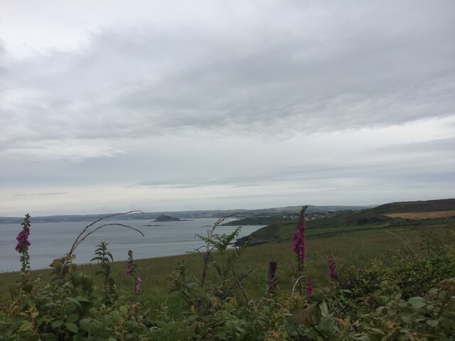
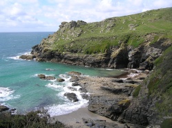
Pestreath Cove is a picturesque coastal area located in Cornwall, England. It is renowned for its stunning natural beauty, serene atmosphere, and diverse marine ecosystem. Nestled between rocky cliffs, the cove offers visitors breathtaking views of the sea, an estuary, and a creek, making it a haven for nature lovers and outdoor enthusiasts.

The cove's pristine sandy beach stretches along the coastline, providing a perfect spot for sunbathing, picnicking, and enjoying the sound of crashing waves. Its crystal-clear turquoise waters are ideal for swimming and snorkeling, allowing visitors to explore the vibrant underwater world teeming with marine life.

To the east of the cove lies a tranquil estuary, where the sea meets a river, creating a unique ecosystem rich in biodiversity. The estuary is home to a wide variety of bird species, including herons, egrets, and oystercatchers, making it a popular destination for birdwatching.

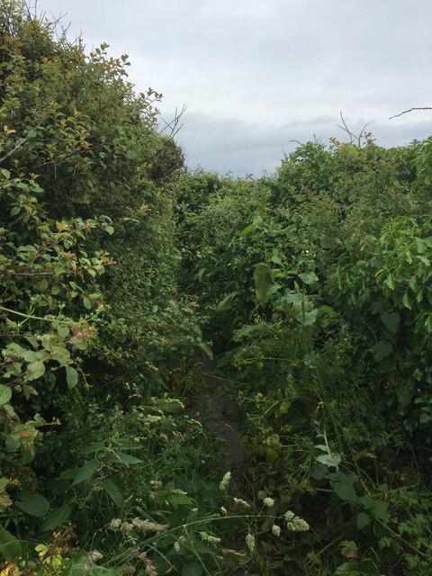
To the west, a meandering creek winds its way through the lush greenery, providing an idyllic setting for peaceful walks and nature trails. The creek is flanked by dense vegetation and is often visited by otters, seals, and other wildlife.

Pestreath Cove offers a sense of tranquility and escape from the hustle and bustle of everyday life. It is a hidden gem where visitors can connect with nature, immerse themselves in its beauty, and experience the magic of Cornwall's coastal landscape.

If you have any feedback on the listing, please let us know in the comments section below.

Pestreath Cove Images

Images are sourced within 2km of 50.103483/-5.4049876 or Grid Reference SW5628. Thanks to Geograph Open Source API. All images are credited.

Views out to sea from PROW
Very overgrown footpath
Lovely coastline
Lovely coastline
Cudden Point Trig Point Flush Bracket S8075 <span class="nowrap"><a title="http://trigpointing.uk/trig/2667" rel="nofollow ugc noopener" href="http://trigpointing.uk/trig/2667">Link</a><img style="margin-left:2px;" alt="External link" title="External link - shift click to open in new window" src="https://s1.geograph.org.uk/img/external.png" width="10" height="10"/></span>
Cudden Point Trig Point Flush Bracket S8075
Coastal views
Coastal views
Prussia Cove
Prussia Cove
Looking down on Kenneggy Sand
Looking along Kenneggy Cliff  From the old mine.
Looking along Kenneggy Cliff
From the old mine.
The old mine above Kenneggy Sand
The footpath near the old mine
Farm tracks and footpaths A complicated junction on the way to the Coast Path.
Farm tracks and footpaths
A complicated junction on the way to the Coast Path.
The entrance to Higher Kenneggy wild camping site
Higher Kenneggy wild campsite Very few facilities, if not exactly 'wild'.
Higher Kenneggy wild campsite
Very few facilities, if not exactly 'wild'.
Private property alongside the bridleway The landowner is keen that walkers stay on the public right of way.
Private property alongside the bridleway
The landowner is keen that walkers stay on the public right of way.
Coastal rocks near Pestreath Cove
The Coast Path near Pestreath Cove The path just passes through the corner of this square.
The Coast Path near Pestreath Cove
The path just passes through the corner of this square.
A hidden archway at Hoe Point This is a complex area of channels and stacks, not often accessed except by fishermen.
A hidden archway at Hoe Point
This is a complex area of channels and stacks, not often accessed except by fishermen.
The entrance to the zawn at Hoe Point The red rope and steel staples in the rock are an aid for the fishermen's access to the water.
The entrance to the zawn at Hoe Point
The red rope and steel staples in the rock are an aid for the fishermen's access to the water.
Show me another place!

Pestreath Cove is located at Grid Ref: SW5628 (Lat: 50.103483, Lng: -5.4049876)

Unitary Authority: Cornwall

Police Authority: Devon and Cornwall

What 3 Words

///drilling.disposing.proofs. Near Germoe, Cornwall

Related Wikis

Kenneggy

Kenneggy comprises two separate hamlets, Higher Kenneggy (Cornish: Keunegi Wartha) to the west and Lower Kennegy (Cornish: Keunegi Woles) to the east,...

Prussia Cove

Prussia Cove (Cornish: Porth Legh), formerly called King's Cove, is a small private estate on the coast of Mount's Bay and to the east of Cudden Point...

Kenneggy Downs

Kenneggy Downs is a hamlet on the A394, between the towns of Helston and Penzance in Cornwall, UK. It is in the west of the civil parish of Breage and...

Newtown, Cornwall

Newtown is a hamlet in the parish of Germoe, Cornwall, England. == References ==

Nearby Amenities

Located within 500m of 50.103483,-5.4049876
Source: PGS
Lat/Long: 50.1039396/-5.411542
Source: PGS
Lat/Long: 50.1041011/-5.410173
Source: PGS
Lat/Long: 50.1041637/-5.4089998
Source: PGS
Lat/Long: 50.1040141/-5.4077871
Created By: almien_coastlines
Source: PGS
Lat/Long: 50.10376/-5.406196
Source: PGS
Lat/Long: 50.1034899/-5.4057972
Source: PGS
Lat/Long: 50.1033589/-5.4045578
Source: PGS
Lat/Long: 50.1027468/-5.4035289
Created By: almien_coastlines
Source: PGS
Lat/Long: 50.102426/-5.402542
Source: PGS
Lat/Long: 50.1022827/-5.4018731
Source: PGS
Lat/Long: 50.1018921/-5.4012348
Source: PGS
Lat/Long: 50.101799/-5.4004408
Source: PGS
Lat/Long: 50.1013992/-5.4000428
Source: PGS
Lat/Long: 50.1012101/-5.3995104
The data included in this document is from www.openstreetmap.org. The data is made available under ODbL.

Have you been to Pestreath Cove?

Leave your review of Pestreath Cove below (or comments, questions and feedback).