Am Miadar

Cliff, Slope in Argyllshire

Scotland

Am Miadar

Corpach Bay on Jura
Corpach Bay on Jura Credit: Nick Ray

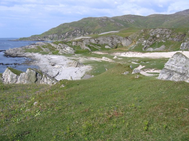
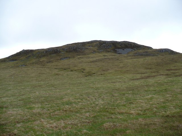
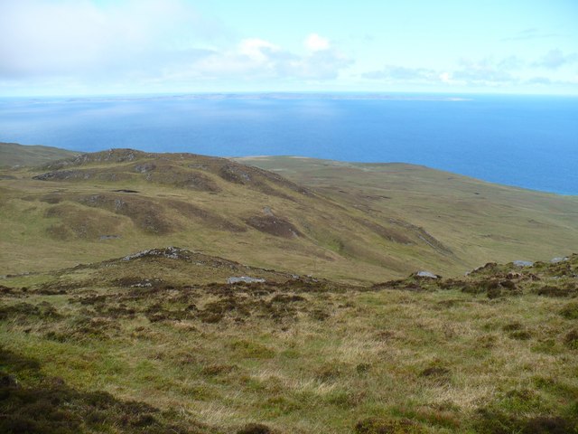
Am Miadar, located in Argyllshire, Scotland, is a picturesque cliff situated on the western coast of the country. With its breathtaking views and natural beauty, it attracts visitors from all over the world.

The cliff stands tall and imposing, overlooking the Atlantic Ocean, providing a dramatic backdrop to the surrounding landscape. Its rugged and rocky terrain adds to its charm, creating a sense of awe and wonder among those who visit. The cliff is known for its steep slopes, which offer a challenging yet rewarding experience for hikers and climbers.

The vegetation on the cliff is diverse, with hardy plants clinging to the rocky surfaces. Mosses, lichens, and heather can be found dotting the landscape, adding splashes of color to the otherwise rugged and barren environment.

For wildlife enthusiasts, Am Miadar is a haven. Seabirds can be seen nesting on the cliff ledges, including gannets, puffins, and guillemots. The waters below are home to various marine species, such as seals and dolphins, making it a popular spot for wildlife watching.

The cliff is easily accessible via a well-maintained footpath, allowing visitors to explore its beauty safely. However, caution is advised due to the steepness of the slopes and unpredictable weather conditions. Visitors are advised to wear appropriate clothing and footwear to ensure their safety.

Overall, Am Miadar in Argyllshire is a must-visit destination for nature lovers and outdoor enthusiasts. Its stunning cliffs, diverse vegetation, and abundant wildlife make it a truly remarkable place to experience the raw beauty of Scotland's western coast.

If you have any feedback on the listing, please let us know in the comments section below.

Am Miadar Images

Images are sourced within 2km of 56.048589/-5.9142462 or Grid Reference NR5690. Thanks to Geograph Open Source API. All images are credited.

Corpach Bay on Jura
Corpach Bay on Jura
Northern tip of Corpach Bay From the end of the rocks you get a good view into Corpach Bay, a well-known sandy beach and camping spot.
Northern tip of Corpach Bay
From the end of the rocks you get a good view into Corpach Bay, a well-known sandy beach and camping spot.
Sandy bay south of Corpach A lovely sandy area full of rabbits (and goats). It is one of only a handful of sandy places on the west coast. Corpach Bay can just be seen to the north.
Sandy bay south of Corpach
A lovely sandy area full of rabbits (and goats). It is one of only a handful of sandy places on the west coast. Corpach Bay can just be seen to the north.
Natural Arch A natural arch or really it's more a tunnel. One of many on the west coast of Jura. A sand dune can be seen through the arch.
Natural Arch
A natural arch or really it's more a tunnel. One of many on the west coast of Jura. A sand dune can be seen through the arch.
West coast of Jura West coast of Jura scenery. The island of Colonsay can just be seen on the horizon.
West coast of Jura
West coast of Jura scenery. The island of Colonsay can just be seen on the horizon.
Approaching Corpach Bay Once past these cliffs you reach the lovely Corpach Bay.
Approaching Corpach Bay
Once past these cliffs you reach the lovely Corpach Bay.
Grassy slopes into Cruaidh Ghleann Grassy slopes lead down into Cruaidh Ghleann. Crags beyond rise to the summit of Dubh Bheinn, the highest hill on the north part of Jura.
Grassy slopes into Cruaidh Ghleann
Grassy slopes lead down into Cruaidh Ghleann. Crags beyond rise to the summit of Dubh Bheinn, the highest hill on the north part of Jura.
Abhainn na Corpaich The Abhainn na Corpaich is in a little gorge here as it drops to the sea at Corpach Bay. Ben More on the island of Mull stands out in the distance.
Abhainn na Corpaich
The Abhainn na Corpaich is in a little gorge here as it drops to the sea at Corpach Bay. Ben More on the island of Mull stands out in the distance.
Mi-mheall Dubh The little summit of Mi-mheall Dubh rises from the coastal grasslands on the west side of Jura.
Mi-mheall Dubh
The little summit of Mi-mheall Dubh rises from the coastal grasslands on the west side of Jura.
Mi-mheall Breac This lump is on the western ridge of Dubh Bheinn, which is the highest summit on the northern part of Jura.
Mi-mheall Breac
This lump is on the western ridge of Dubh Bheinn, which is the highest summit on the northern part of Jura.
Western side of Dubh Bheinn Looking down to the col between Dubh Bheinn and Mi-mheall Breac. Colonsay can be seen in the distance.
Western side of Dubh Bheinn
Looking down to the col between Dubh Bheinn and Mi-mheall Breac. Colonsay can be seen in the distance.
Show me another place!

Am Miadar is located at Grid Ref: NR5690 (Lat: 56.048589, Lng: -5.9142462)

Unitary Authority: Argyll and Bute

Police Authority: Argyll and West Dunbartonshire

What 3 Words

///rhino.parks.initiates. Near Scalasaig, Argyll & Bute

Related Wikis

Ardlussa Fishing Loch

The Ardlussa Fishing Loch is an impounding reservoir, located 2 kilometres north of Lussagiven on a remote part of the Ardlussa Estate on Jura, Argyll...

Inverlussa

Inverlussa is a hamlet 1 mile (1.6 km) southwest of Ardlussa and 14 miles from Craighouse at the mouth of Lussa River on the east coast of the island of...

Ardlussa

Ardlussa is a hamlet and estate on The Long Road, just north of the Lussa River, overlooking Ardlussa Bay on the east coast of the island of Jura, in the...

Nearby Amenities

Located within 500m of 56.048589,-5.9142462
Am Miadar
Place: locality
Lat/Long: 56.0486378/-5.9163308
Uamh nan Gruagach
Natural: cave_entrance
Source: OS_OpenData_StreetView
Lat/Long: 56.0469314/-5.9202131
The data included in this document is from www.openstreetmap.org. The data is made available under ODbL.

Have you been to Am Miadar?

Leave your review of Am Miadar below (or comments, questions and feedback).