Taing of Blogars-hellia

Coastal Feature, Headland, Point in Shetland

Scotland

Taing of Blogars-hellia

Helli Ness to Bard Head We are at the parking place above Crossie Geo halfway between Lerwick and Sumburgh Head on the mainland of Shetland and I am looking north east across Greenmow and Helli Ness to Bard Head, Bressay. The Isle of Noss can be seen beyond Bressay.
Helli Ness to Bard Head Credit: Carroll Pierce

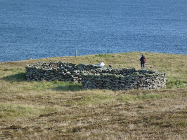
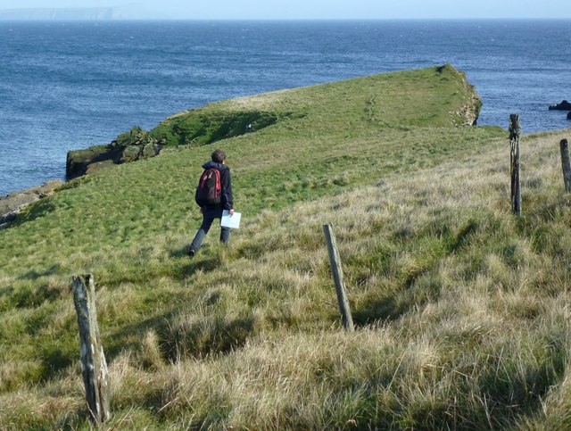
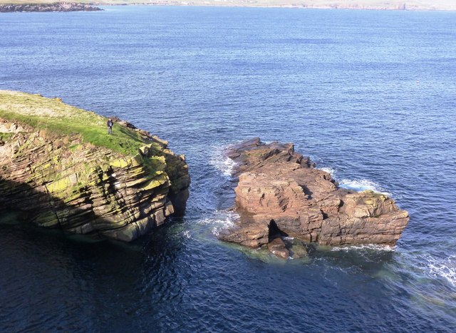
Ting of Blogars-hellia is a prominent coastal feature located on the Shetland Islands, a Scottish archipelago in the North Atlantic Ocean. Situated on the western coast of the mainland, this headland or point effectively marks the end of the Blogars Ness peninsula.

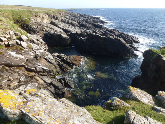
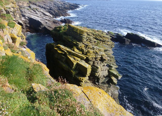
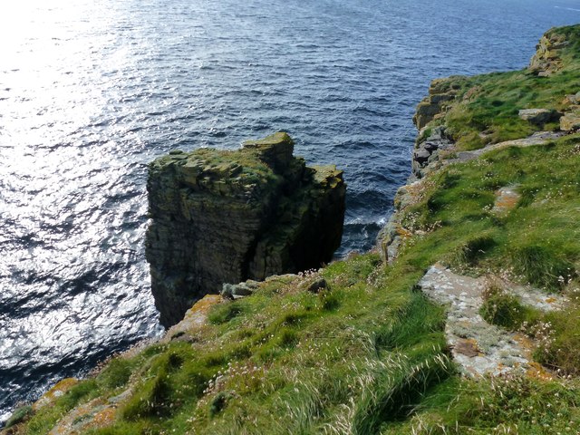
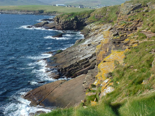
The Ting of Blogars-hellia is known for its rugged and dramatic cliffs that rise steeply from the sea, reaching impressive heights. The rocky terrain and jagged edges give it a unique character, making it a popular spot for nature enthusiasts and photographers. The name "Ting" comes from the Old Norse word for a meeting place or assembly, reflecting the historical significance of the site.

This coastal feature offers breathtaking panoramic views of the surrounding coastline and the vast expanse of the North Atlantic Ocean beyond. Visitors often flock to the Ting of Blogars-hellia to witness the stunning sunsets that illuminate the sky and create a mesmerizing color palette reflecting on the water.

The area around Ting of Blogars-hellia is rich in wildlife, providing a habitat for various seabird species such as fulmars, guillemots, and puffins. The crashing waves and strong winds at this exposed location also make it an ideal spot for birdwatching, as migratory birds often pass by.

Although the cliffs and terrain can be treacherous, there are designated paths and viewing areas to ensure the safety of visitors. The Ting of Blogars-hellia is a truly captivating coastal feature that showcases the raw beauty of the Shetland Islands' landscape.

If you have any feedback on the listing, please let us know in the comments section below.

Taing of Blogars-hellia Images

Images are sourced within 2km of 60.054427/-1.1981975 or Grid Reference HU4430. Thanks to Geograph Open Source API. All images are credited.

Helli Ness to Bard Head We are at the parking place above Crossie Geo halfway between Lerwick and Sumburgh Head on the mainland of Shetland and I am looking north east across Greenmow and Helli Ness to Bard Head, Bressay. The Isle of Noss can be seen beyond Bressay.
Helli Ness to Bard Head
We are at the parking place above Crossie Geo halfway between Lerwick and Sumburgh Head on the mainland of Shetland and I am looking north east across Greenmow and Helli Ness to Bard Head, Bressay. The Isle of Noss can be seen beyond Bressay.
Aith, Cunningsburgh, from the air
Greenmow and Helli Ness, Cunningsburgh, from the air
Aithsetter, Cunningsburgh, from the air
Ukinsetter, Fladdabister, from the air
A970 at Cunningsburgh Cunningsburgh, formerly also known as Coningsburgh (from the Old Norse: Konungsborgr meaning "King's castle"), is a hamlet on the coast of Mainland Shetland, nine miles south-west of Lerwick, about halfway between there and Sumburgh Head.
A970 at Cunningsburgh
Cunningsburgh, formerly also known as Coningsburgh (from the Old Norse: Konungsborgr meaning "King's castle"), is a hamlet on the coast of Mainland Shetland, nine miles south-west of Lerwick, about halfway between there and Sumburgh Head.
Bus Stop at Cunningsburgh Bus stop outside Cunningsburgh Primary School.
Bus Stop at Cunningsburgh
Bus stop outside Cunningsburgh Primary School.
Bus Stop on the A970 at Cunningsburgh Cunningsburgh, formerly also known as Coningsburgh (from the Old Norse: Konungsborgr meaning "King's castle"), is a hamlet on the coast of Mainland Shetland, nine miles south-west of Lerwick, about halfway between there and Sumburgh Head.
Bus Stop on the A970 at Cunningsburgh
Cunningsburgh, formerly also known as Coningsburgh (from the Old Norse: Konungsborgr meaning "King's castle"), is a hamlet on the coast of Mainland Shetland, nine miles south-west of Lerwick, about halfway between there and Sumburgh Head.
Burn Of Aith Broch This mound has been identified as the remains of a broch. <span class="nowrap"><a title="https://canmore.org.uk/site/939/burn-of-aith" rel="nofollow ugc noopener" href="https://canmore.org.uk/site/939/burn-of-aith">Link</a><img style="margin-left:2px;" alt="External link" title="External link - shift click to open in new window" src="https://s1.geograph.org.uk/img/external.png" width="10" height="10"/></span>
Burn Of Aith Broch
This mound has been identified as the remains of a broch. LinkExternal link
Aithsvoe Marina A very nice facility, built in 2004, still looking new.
The biggish boat off the water is the Mousa Ferry (Solan IV); both it <a href="https://www.geograph.org.uk/photo/1180671">HU4428 : Mousa ferry at winter home, Aithsvoe, Cunningsburgh</a> and the ferry business is up for sale (2011)
Aithsvoe Marina
A very nice facility, built in 2004, still looking new. The biggish boat off the water is the Mousa Ferry (Solan IV); both it HU4428 : Mousa ferry at winter home, Aithsvoe, Cunningsburgh and the ferry business is up for sale (2011)
Planticrubs Turri Ness These, usually round, structures are to be found all over Shetland.
The near one, in this case, is still in use (few are).
Traditionally used for growing Kale or Cabbages in shelter and protected from rabbits and livestock.
In this case all but a few red cabbage seedlings had been recently removed.
Nice old pictures here - <span class="nowrap"><a title="http://shetlopedia.com/Planticrubs" rel="nofollow ugc noopener" href="http://shetlopedia.com/Planticrubs">Link</a><img style="margin-left:2px;" alt="External link" title="External link - shift click to open in new window" src="https://s1.geograph.org.uk/img/external.png" width="10" height="10"/></span>
Planticrubs Turri Ness
These, usually round, structures are to be found all over Shetland. The near one, in this case, is still in use (few are). Traditionally used for growing Kale or Cabbages in shelter and protected from rabbits and livestock. In this case all but a few red cabbage seedlings had been recently removed. Nice old pictures here - LinkExternal link
Shetland Crub The Planticrub <a href="https://www.geograph.org.uk/photo/2622576">HU4529 : Planticrubs Turri Ness</a> here is in use. It is totally closed off to protect the cabbage plants.
Dot stands on the step used for access.
The tanker Loch Rannoch sits way out, biding her time.
Shetland Crub
The Planticrub HU4529 : Planticrubs Turri Ness here is in use. It is totally closed off to protect the cabbage plants. Dot stands on the step used for access. The tanker Loch Rannoch sits way out, biding her time.
Hellia A small peninsula in Uxna Geo reaching into another grid square
Hellia
A small peninsula in Uxna Geo reaching into another grid square
Uxna Geo The tip of Hellia just in the square
Uxna Geo
The tip of Hellia just in the square
Runties Geo Clear water and steep nearby cliffs.
The coastal path is easy to follow to this point.
Runties Geo
Clear water and steep nearby cliffs. The coastal path is easy to follow to this point.
Detached Stack Could it be called Yar Neap?
I missed the opportunity to photograph it from Runties Geo.
This is the summit platform from the edge just beyond it looking back to Runties
Detached Stack
Could it be called Yar Neap? I missed the opportunity to photograph it from Runties Geo. This is the summit platform from the edge just beyond it looking back to Runties
Yar Neap? The name on the map may be misleading.
Another view of <a href="https://www.geograph.org.uk/photo/2632737">HU4528 : Detached Stack</a>
Yar Neap?
The name on the map may be misleading. Another view of HU4528 : Detached Stack
Sep Geo From the east looking towards Skervi Geo and Aness
Sep Geo
From the east looking towards Skervi Geo and Aness
Show me another place!

Taing of Blogars-hellia is located at Grid Ref: HU4430 (Lat: 60.054427, Lng: -1.1981975)

Unitary Authority: Shetland Islands

Police Authority: Highlands and Islands

What 3 Words

///torches.flickers.decide. Near Sandwick, Shetland Islands

Related Wikis

Aithsetter

Aithsetter (Old Norse: EiĆ°seti, meaning "the farm at the isthmus") is a village on the island of Mainland, in Shetland, Scotland. Aithsetter is in the...

Cunningsburgh

Cunningsburgh, formerly also known as Coningsburgh (Old Norse: Konungsborgr meaning "King's castle"), is a new hamlet and ancient parish in the south of...

Bremirehoull

Bremirehoull is a settlement on the island of Mainland, in Shetland, Scotland. Bremirehoull is situated on the A970 in the Cunningsburgh area. == References... ==

Mail, Shetland

Mail is a hamlet on the island of Mainland, in the Shetland Islands, Scotland. == Geography == Mail is located on the south-eastern side of the island...

Nearby Amenities

Located within 500m of 60.054427,-1.1981975
Power: pole
Lat/Long: 60.0550479/-1.2069653
Power: pole
Lat/Long: 60.0545716/-1.2057225
The data included in this document is from www.openstreetmap.org. The data is made available under ODbL.

Have you been to Taing of Blogars-hellia?

Leave your review of Taing of Blogars-hellia below (or comments, questions and feedback).