Hoga

Coastal Feature, Headland, Point in Shetland

Scotland

Hoga

Mousa and the Broch We are at the parking place above Crossie Geo just north of Leebitten, roughly half-way between Sumburgh Head and Lerwick on the mainland of Shetlant, and looking across Mousa Sound to the island of Mousa and the Broch of Mousa. The wind proved to be too strong on this particular day for us to make the crossing to view the broch close up.
Mousa and the Broch Credit: Carroll Pierce

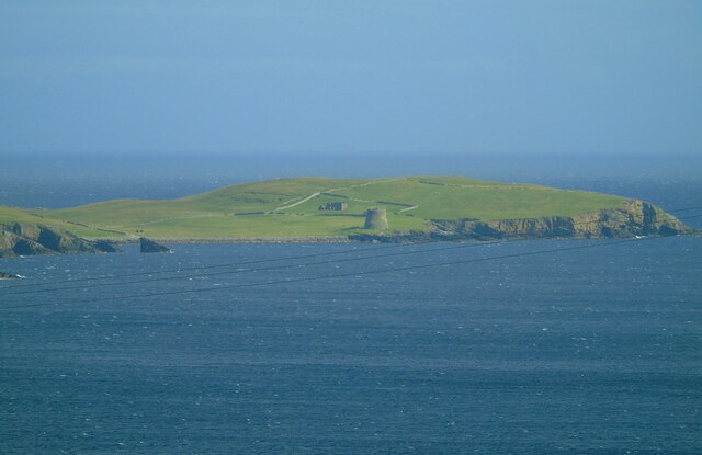
Hoga is a small coastal headland located in the Shetland Islands, an archipelago situated off the northeast coast of Scotland. This scenic and rugged feature is known for its dramatic cliffs, rocky shoreline, and stunning views of the North Sea.

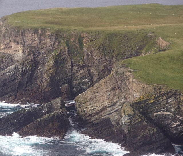
Situated on the eastern side of the mainland, Hoga is characterized by its steep and towering cliffs that rise up to 100 meters above sea level. These cliffs are composed of layers of sedimentary rocks, displaying different hues of red, orange, and gray, giving the area a visually striking appearance. The headland is also home to several caves and natural arches, which have been carved out by the relentless force of the sea over thousands of years.

The exposed location of Hoga makes it susceptible to strong winds and rough seas, creating a harsh and challenging environment for both humans and wildlife. However, this also makes it an ideal spot for birdwatching, as the headland is home to various seabird species, including fulmars, gannets, and puffins. It is not uncommon to spot seals and otters in the surrounding waters as well.

Hoga is a popular destination for nature enthusiasts, hikers, and photographers who are drawn to its wild and untamed beauty. The headland offers breathtaking views of the surrounding coastline and the nearby islands, making it a perfect spot to capture the essence of the Shetland Islands' rugged charm.

If you have any feedback on the listing, please let us know in the comments section below.

Hoga Images

Images are sourced within 2km of 59.990548/-1.1997965 or Grid Reference HU4423. Thanks to Geograph Open Source API. All images are credited.

Mousa and the Broch We are at the parking place above Crossie Geo just north of Leebitten, roughly half-way between Sumburgh Head and Lerwick on the mainland of Shetlant, and looking across Mousa Sound to the island of Mousa and the Broch of Mousa. The wind proved to be too strong on this particular day for us to make the crossing to view the broch close up.
Mousa and the Broch
We are at the parking place above Crossie Geo just north of Leebitten, roughly half-way between Sumburgh Head and Lerwick on the mainland of Shetlant, and looking across Mousa Sound to the island of Mousa and the Broch of Mousa. The wind proved to be too strong on this particular day for us to make the crossing to view the broch close up.
No Ness from the air
Loch of Noness from the air
Broch of Mousa from the air
West Ham and East Ham, Mousa, from the air
Meadowbank, Sandwick, from the air
Sanick, Sandwick, from the air
Sand Wick, Sandwick, from the air
Mousa Sound and Mousa from the air
Noness, Sandwick, from the air
No Ness, Sandwick, from the air
Broch of Mousa Taken from the viewing point on the South Road above Leebitten, Sandwick, on the main island of Shetland, I am looking south east towards the island of Mousa. The Broch of Mousa (centre of shot) is the best-preserved of Scotland's brochs or Iron Age roundhouses. The island can be accessed by boat from Sandwick (weather and wind permitting).
Broch of Mousa
Taken from the viewing point on the South Road above Leebitten, Sandwick, on the main island of Shetland, I am looking south east towards the island of Mousa. The Broch of Mousa (centre of shot) is the best-preserved of Scotland's brochs or Iron Age roundhouses. The island can be accessed by boat from Sandwick (weather and wind permitting).
The Broch of Mousa Looking north towards Burgi Ayre.
The Broch of Mousa
Looking north towards Burgi Ayre.
The Broch of Mousa The detail of the stonework is very clear in this photo. The entrance is on the left, and inside it is possible to climb to the top of the tower - hence the railings.
The Broch of Mousa
The detail of the stonework is very clear in this photo. The entrance is on the left, and inside it is possible to climb to the top of the tower - hence the railings.
The top of the broch The stairs descend to the left from the gate between the walls. Note the grid, bottom right, to prevent falls back into the broch.

Top right is the ruin of The Haa, the former residence of the laird of the island.
The top of the broch
The stairs descend to the left from the gate between the walls. Note the grid, bottom right, to prevent falls back into the broch. Top right is the ruin of The Haa, the former residence of the laird of the island.
The interior of the Broch of Mousa Excellent detail in the stonework. The exit is at bottom centre, veering left.
The interior of the Broch of Mousa
Excellent detail in the stonework. The exit is at bottom centre, veering left.
Broch of Mousa - the start of the descent The climb and descent of the Broch of Mousa is by a fairly steep spiral staircase, and the treads are quite narrow. So the provision of a modern handrail is a useful precaution.
Broch of Mousa - the start of the descent
The climb and descent of the Broch of Mousa is by a fairly steep spiral staircase, and the treads are quite narrow. So the provision of a modern handrail is a useful precaution.
Show me another place!

Hoga is located at Grid Ref: HU4423 (Lat: 59.990548, Lng: -1.1997965)

Unitary Authority: Shetland Islands

Police Authority: Highlands and Islands

What 3 Words

///purple.taker.revolting. Near Sandwick, Shetland Islands

Related Wikis

Broch of Mousa

Broch of Mousa (or Mousa Broch) is a preserved Iron Age broch or round tower. It is on the island of Mousa in Shetland, Scotland. It is the tallest broch...

Sandwick, Dunrossness

see also Sandwick, Whalsay and Sandwick, OrkneySandwick (Old Norse: Sandvik "Sandy Bay") is a village and an ancient parish in the Shetland Islands, Scotland...

Mousa

Mousa (Old Norse: Mosey "moss island") is a small island in Shetland, Scotland, uninhabited since the nineteenth century. The island is known for the...

Peerie Bard

Perie Bard is one of the Shetland Islands. It is a small islet off the east coast of the island of Mousa.Although named 'Perie Bard' on OS Maps, the name...

Hoswick

Hoswick is a settlement in Sandwick in the south mainland of Shetland, Scotland, on the eastern part of the Dunrossness civil parish. It is separated from...

Levenwick

Levenwick is a small village about 17 miles (27 km) south of Lerwick, on the east side of the South Mainland of Shetland, Scotland. It is part of the parish...

Catpund

Catpund is a quarry site in Shetland, Scotland, where steatite vessels were cut from the rock from prehistory onwards. The quarrying marks are still visible...

Mail, Shetland

Mail is a hamlet on the island of Mainland, in the Shetland Islands, Scotland. == Geography == Mail is located on the south-eastern side of the island...

Nearby Amenities

Located within 500m of 59.990548,-1.1997965
Broch of Burraland
Historic: archaeological_site
Lat/Long: 59.9913272/-1.2006694
The data included in this document is from www.openstreetmap.org. The data is made available under ODbL.

Have you been to Hoga?

Leave your review of Hoga below (or comments, questions and feedback).