Aird Ghaineamhach
Coastal Feature, Headland, Point in Inverness-shire
Scotland
Aird Ghaineamhach

Aird Ghaineamhach, also known as Aird Point, is a prominent coastal feature located in Inverness-shire, Scotland. Situated on the western coast of the county, Aird Ghaineamhach is characterized by its rugged cliffs, stunning panoramic views, and its strategic position overlooking the North Atlantic Ocean.
This headland extends out into the ocean, forming a distinctive point that juts into the water. The name Aird Ghaineamhach translates to "sandy headland" in Scottish Gaelic, which accurately describes the sandy cliffs that can be found in certain areas of the headland.
Aird Ghaineamhach offers visitors a captivating natural landscape, with its towering cliffs providing a sanctuary for various seabird species, including guillemots, puffins, kittiwakes, and fulmars. The headland's location also makes it an ideal spot for birdwatching enthusiasts as migratory birds often pass through the area.
In addition to its natural beauty, Aird Ghaineamhach is rich in historical significance. The headland is home to the ruins of an ancient fort, serving as a reminder of the region's historical past. Exploring the remains of this fort provides a glimpse into the lives of the people who inhabited the area centuries ago.
Due to its picturesque views and historical importance, Aird Ghaineamhach attracts both tourists and locals alike. Visitors can enjoy scenic walks along the headland, taking in the breathtaking vistas of the surrounding ocean and coastline. The headland is also a popular destination for photographers, offering endless opportunities to capture the beauty of the Scottish landscape.
In summary, Aird Ghaineamhach in Inverness-shire is a captivating coastal headland, boasting stunning cliffs, a rich variety of birdlife, and historical ruins. Its natural and historical significance make it a must-visit destination for those exploring the Scottish coastline.
If you have any feedback on the listing, please let us know in the comments section below.
Aird Ghaineamhach Images
Images are sourced within 2km of 57.505538/-7.2551799 or Grid Reference NF8558. Thanks to Geograph Open Source API. All images are credited.


![Bus stop and post box on Grimsay At the road-end of a loop that leaves the main road [A865].](https://s0.geograph.org.uk/geophotos/05/02/60/5026016_5d555552.jpg)


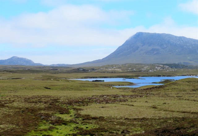


![Sandy inlet on the coast of Grimsay One of a maze of inlets and channels around Grimsay. This view is interesting as there are remains of old field walls [possibly iron age/centre picture] visible in the sand, indicating a lower sea level at some time. Cloud capped Eabhal rises in the distance.](https://s2.geograph.org.uk/geophotos/03/06/37/3063738_51fd0f96.jpg)
Aird Ghaineamhach is located at Grid Ref: NF8558 (Lat: 57.505538, Lng: -7.2551799)
Unitary Authority: Na h-Eileanan an Iar
Police Authority: Highlands and Islands
What 3 Words
///steam.loose.upward. Near Balivanich, Na h-Eileanan Siar
Nearby Locations
Related Wikis

Fraoch-Eilean
Fraoch-eilean is a small island with an uncertain population north of Benbecula in the Outer Hebrides of Scotland. It is about 55 hectares (140 acres...

Baile Glas
Baile Glas or Ballaglasa (Scottish Gaelic: Am Baile Glas) is a settlement on Grimsay in the Outer Hebrides, Scotland. Ballaglasa is within the parish of...

Grimsay
Grimsay (Scottish Gaelic: Griomasaigh) is a tidal island in the Outer Hebrides of Scotland. == Geography == Grimsay is the largest of the low-lying stepping...

Flodaigh
Flodaigh is a tidal island lying to the north of Benbecula and south of Grimsay in the Outer Hebrides, Scotland. It is connected to Benbecula by a causeway...

Carinish
Carinish (Scottish Gaelic: Càirinis), is a hamlet on North Uist, in the Outer Hebrides, Scotland. It is in the south of the island, about two miles (three...

Bail' Iochdrach
Bail' Iochdrach or Baliochrach (Scottish Gaelic: Am Baile Ìochdrach) is a village on Benbecula in the Outer Hebrides, Scotland. Baliochrach is within the...

Battle of Carinish
The Battle of Carinish was a Scottish clan battle fought in North Uist in 1601. It was part of a year of feuding between Clan MacLeod of Dunvegan and the...

Teampull na Trionaid
Teampull na Trionaid ("trinity church") is a ruined 13th-century Augustinian nunnery at Carinish, on North Uist, in the Outer Hebrides of Scotland. �...
Nearby Amenities
Located within 500m of 57.505538,-7.2551799Have you been to Aird Ghaineamhach?
Leave your review of Aird Ghaineamhach below (or comments, questions and feedback).