Bolltravagh
Sea, Estuary, Creek in Inverness-shire
Scotland
Bolltravagh

Bolltravagh is a small coastal settlement located in the picturesque region of Inverness-shire in Scotland. Situated along the eastern coast, it is surrounded by stunning natural beauty consisting of a sea, estuary, and creek.
The settlement is characterized by its proximity to the North Sea, offering residents and visitors breathtaking views of the vast expanse of water. The sea in this area is known for its rich marine life, attracting fishing enthusiasts and wildlife enthusiasts alike. The coastal landscape is adorned with rugged cliffs and sandy beaches, providing opportunities for leisurely walks, picnics, and other outdoor activities.
Bolltravagh is also blessed with an estuary, a partially enclosed coastal body of water where freshwater from rivers and streams meets the salty ocean. This estuary is home to a diverse range of flora and fauna, including various bird species and aquatic life. The estuary serves as an important breeding ground and habitat for many species, making it a popular spot for birdwatching and nature enthusiasts.
A creek meanders through Bolltravagh, adding to the charm of the settlement. This creek provides an idyllic setting for fishing, boating, and other water-based activities. It also serves as a natural waterway for smaller vessels, connecting Bolltravagh to other nearby coastal towns and villages.
Overall, Bolltravagh offers a unique coastal experience with its combination of sea, estuary, and creek. It attracts those seeking tranquility, natural beauty, and opportunities for outdoor exploration and recreation.
If you have any feedback on the listing, please let us know in the comments section below.
Bolltravagh Images
Images are sourced within 2km of 57.509587/-7.2459157 or Grid Reference NF8558. Thanks to Geograph Open Source API. All images are credited.


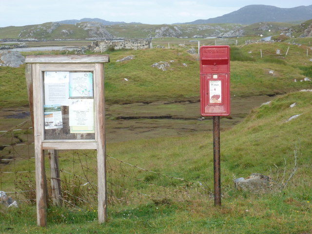
![Bus stop and post box on Grimsay At the road-end of a loop that leaves the main road [A865].](https://s0.geograph.org.uk/geophotos/05/02/60/5026016_5d555552.jpg)


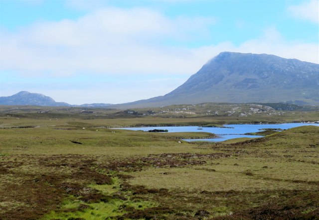


![Sandy inlet on the coast of Grimsay One of a maze of inlets and channels around Grimsay. This view is interesting as there are remains of old field walls [possibly iron age/centre picture] visible in the sand, indicating a lower sea level at some time. Cloud capped Eabhal rises in the distance.](https://s2.geograph.org.uk/geophotos/03/06/37/3063738_51fd0f96.jpg)

Bolltravagh is located at Grid Ref: NF8558 (Lat: 57.509587, Lng: -7.2459157)
Unitary Authority: Na h-Eileanan an Iar
Police Authority: Highlands and Islands
What 3 Words
///jaunts.first.performed. Near Balivanich, Na h-Eileanan Siar
Nearby Locations
Related Wikis

Fraoch-Eilean
Fraoch-eilean is a small island with an uncertain population north of Benbecula in the Outer Hebrides of Scotland. It is about 55 hectares (140 acres...

Baile Glas
Baile Glas or Ballaglasa (Scottish Gaelic: Am Baile Glas) is a settlement on Grimsay in the Outer Hebrides, Scotland. Ballaglasa is within the parish of...

Grimsay
Grimsay (Scottish Gaelic: Griomasaigh) is a tidal island in the Outer Hebrides of Scotland. == Geography == Grimsay is the largest of the low-lying stepping...

Flodaigh
Flodaigh is a tidal island lying to the north of Benbecula and south of Grimsay in the Outer Hebrides, Scotland. It is connected to Benbecula by a causeway...
Nearby Amenities
Located within 500m of 57.509587,-7.2459157Have you been to Bolltravagh?
Leave your review of Bolltravagh below (or comments, questions and feedback).