Loch Nighe

Lake, Pool, Pond, Freshwater Marsh in Inverness-shire

Scotland

Loch Nighe

Eilean na Hoe
Eilean na Hoe Credit: Toby Speight

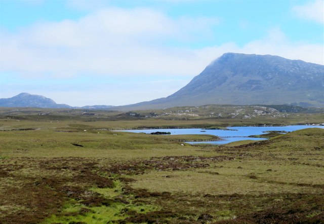
Loch Nighe is a picturesque freshwater lake located in the region of Inverness-shire, Scotland. Nestled amidst the breathtaking Scottish Highlands, this tranquil loch is a haven for nature enthusiasts and those seeking solace amidst stunning natural beauty.

Spanning approximately 2 miles in length, Loch Nighe is surrounded by lush greenery, rolling hills, and dense forests, creating a serene and idyllic setting. The lake's crystal-clear waters shimmer under the sunlight, reflecting the surrounding landscape, and providing a calming atmosphere.

The diverse ecosystem of Loch Nighe supports a wide range of flora and fauna. The lake is home to various species of fish, including brown trout and salmon, making it a popular spot for fishing enthusiasts. Birdwatchers can also enjoy spotting a variety of waterfowl, including ducks and swans, as well as rare and migratory birds that visit the area.

The surrounding marshes and wetlands surrounding Loch Nighe provide a habitat for numerous plant species, such as water lilies and reeds. This rich biodiversity attracts a diverse range of wildlife, including otters, herons, and even the occasional deer.

The tranquil ambiance of Loch Nighe offers visitors the opportunity to partake in various recreational activities. Fishing, boating, and kayaking are popular pastimes on the lake, allowing visitors to explore the waters and enjoy the peaceful surroundings. The scenic walking trails that encircle the loch are perfect for leisurely strolls or invigorating hikes, providing stunning panoramic views of the surrounding landscape.

In summary, Loch Nighe in Inverness-shire is a captivating freshwater lake that offers visitors a chance to immerse themselves in the natural beauty of the Scottish Highlands. With its diverse ecosystem and abundance of recreational activities, Loch Nighe is a must-visit destination for nature lovers and those seeking a peaceful retreat.

If you have any feedback on the listing, please let us know in the comments section below.

Loch Nighe Images

Images are sourced within 2km of 57.504685/-7.2478017 or Grid Reference NF8558. Thanks to Geograph Open Source API. All images are credited.

Eilean na Hoe
Eilean na Hoe
Ocean on the west side of the causeway to North Uist
NCN780 on Grimsay Looking east, Loch an Fhaing on the left and Eaval, North Uist, in the distance.
NCN780 on Grimsay
Looking east, Loch an Fhaing on the left and Eaval, North Uist, in the distance.
Signpost on Grimsay The house beyond the end of Loch an Fhaing is marked as a Post Office on the map, but the may not be up to date information.
Signpost on Grimsay
The house beyond the end of Loch an Fhaing is marked as a Post Office on the map, but the may not be up to date information.
Bus stop and post box on Grimsay At the road-end of a loop that leaves the main road [A865].
Bus stop and post box on Grimsay
At the road-end of a loop that leaves the main road [A865].
House on Grimsay Looking across Bog Cotton from the A865.
House on Grimsay
Looking across Bog Cotton from the A865.
Gearraidh Dubh Looking over the shore near Gearraidh Dubh towards Eabhal.
Gearraidh Dubh
Looking over the shore near Gearraidh Dubh towards Eabhal.
Loch na Faoileag on Grimsay One of many small islets on Loch na Faoileag on the Isle of Grimsay
Loch na Faoileag on Grimsay
One of many small islets on Loch na Faoileag on the Isle of Grimsay
Loch na Faoileag Shoreline A view along the shoreline to north west finger on Loch na Faoileag (Isle of Grimsay) .Taken on the opposite bank from the roadside.
Loch na Faoileag Shoreline
A view along the shoreline to north west finger on Loch na Faoileag (Isle of Grimsay) .Taken on the opposite bank from the roadside.
Near Gearraidh Dubh
Near Gearraidh Dubh
Gairbh-eilean
Gairbh-eilean
Barp Hacklett Cairn One cannot be absolutely sure if this is the cairn as the OS map doesn't give a detailed site, but as it is the only pile of stones on a green protuberance on an otherwise rather squelchy moor, then one would suggest that this is it.
Barp Hacklett Cairn
One cannot be absolutely sure if this is the cairn as the OS map doesn't give a detailed site, but as it is the only pile of stones on a green protuberance on an otherwise rather squelchy moor, then one would suggest that this is it.
Eilean an t-Seagail Seating located at a parking spot just off the A865 near Baile Glas on Benbecula.
Eilean an t-Seagail
Seating located at a parking spot just off the A865 near Baile Glas on Benbecula.
View towards Loch nan Garbh Chlachan Peat and heather moorland stretch away towards the shores of Loch nan Garbh Chlachan where a line of stepping stones are visible, beyond which in an adjoining square is Dun Ban on an islet. Magnifying the image brings up what looks like some remains of walls at the dun. In the distance is the familiar outline of Eabhal.
View towards Loch nan Garbh Chlachan
Peat and heather moorland stretch away towards the shores of Loch nan Garbh Chlachan where a line of stepping stones are visible, beyond which in an adjoining square is Dun Ban on an islet. Magnifying the image brings up what looks like some remains of walls at the dun. In the distance is the familiar outline of Eabhal.
Thatch at Cladach Chairinis
The summit region of Grimsay Grimsay is a low island between North Uist and Benbecula. It is difficult to be certain of its highest point, but this eminence, 25m or so above Mean Sea Level, is a good contender.
The summit region of Grimsay
Grimsay is a low island between North Uist and Benbecula. It is difficult to be certain of its highest point, but this eminence, 25m or so above Mean Sea Level, is a good contender.
Baile Glas, Grimsay Hamlet on the causewayed road between Benbecula and North Uist.
<span class="nowrap"><a title="http://www.isle-of-benbecula.co.uk/" rel="nofollow ugc noopener" href="http://www.isle-of-benbecula.co.uk/">Link</a><img style="margin-left:2px;" alt="External link" title="External link - shift click to open in new window" src="https://s1.geograph.org.uk/img/external.png" width="10" height="10"/></span>
Baile Glas, Grimsay
Hamlet on the causewayed road between Benbecula and North Uist. LinkExternal link
Sand Flats at Grimsay Tidal flats between Grimsay (foreground) and North Uist (background). Eaval / Eabhal is the distinctive mountain.
Sand Flats at Grimsay
Tidal flats between Grimsay (foreground) and North Uist (background). Eaval / Eabhal is the distinctive mountain.
Show me another place!

Loch Nighe is located at Grid Ref: NF8558 (Lat: 57.504685, Lng: -7.2478017)

Unitary Authority: Na h-Eileanan an Iar

Police Authority: Highlands and Islands

What 3 Words

///unscrew.ferried.before. Near Balivanich, Na h-Eileanan Siar

Related Wikis

Fraoch-Eilean

Fraoch-eilean is a small island with an uncertain population north of Benbecula in the Outer Hebrides of Scotland. It is about 55 hectares (140 acres...

Baile Glas

Baile Glas or Ballaglasa (Scottish Gaelic: Am Baile Glas) is a settlement on Grimsay in the Outer Hebrides, Scotland. Ballaglasa is within the parish of...

Grimsay

Grimsay (Scottish Gaelic: Griomasaigh) is a tidal island in the Outer Hebrides of Scotland. == Geography == Grimsay is the largest of the low-lying stepping...

Flodaigh

Flodaigh is a tidal island lying to the north of Benbecula and south of Grimsay in the Outer Hebrides, Scotland. It is connected to Benbecula by a causeway...

Carinish

Carinish (Scottish Gaelic: Càirinis), is a hamlet on North Uist, in the Outer Hebrides, Scotland. It is in the south of the island, about two miles (three...

Bail' Iochdrach

Bail' Iochdrach or Baliochrach (Scottish Gaelic: Am Baile Ìochdrach) is a village on Benbecula in the Outer Hebrides, Scotland. Baliochrach is within the...

Battle of Carinish

The Battle of Carinish was a Scottish clan battle fought in North Uist in 1601. It was part of a year of feuding between Clan MacLeod of Dunvegan and the...

Ronay

Ronay (Scottish Gaelic: Rònaigh) is an island in the Outer Hebrides of Scotland, which lies a short distance off the east coast of Grimsay. == Geography... ==

Nearby Amenities

Located within 500m of 57.504685,-7.2478017
Created By: dmgroom_coastlines
Lat/Long: 57.50117/-7.2522598
Created By: dmgroom_coastlines
Lat/Long: 57.50142/-7.2520098
Seana Bhaile
Name En: Seanabaily
Name Gd: Seana Bhaile
Place: hamlet
Population: 10
Lat/Long: 57.5045439/-7.242031
Barrier: cattle_grid
Lat/Long: 57.5023282/-7.2454972
Passing Place
Lat/Long: 57.5013509/-7.2440048
Gearra Dubh
Name En: Gearadu
Name Gd: Gearra Dubh
Place: isolated_dwelling
Lat/Long: 57.5003858/-7.2483856
Passing Place
Lat/Long: 57.5010302/-7.2483202
Barrier: cattle_grid
Lat/Long: 57.5084762/-7.2486459
Power: pole
Lat/Long: 57.5086829/-7.2495845
Power: pole
Lat/Long: 57.5081686/-7.248643
Power: pole
Lat/Long: 57.507853/-7.2480503
Power: pole
Lat/Long: 57.508376/-7.2496811
Power: pole
Lat/Long: 57.5072796/-7.2472483
Power: pole
Lat/Long: 57.5058127/-7.2467119
Power: pole
Lat/Long: 57.5073026/-7.2470498
Power: pole
Lat/Long: 57.5058228/-7.2465
Power: pole
Lat/Long: 57.5053207/-7.2463229
Power: pole
Lat/Long: 57.5048876/-7.246162
Power: pole
Lat/Long: 57.5049755/-7.2464315
Power: pole
Lat/Long: 57.5040591/-7.2460561
Power: pole
Lat/Long: 57.5036887/-7.2462773
Power: pole
Lat/Long: 57.5029026/-7.2467065
Power: pole
Lat/Long: 57.5040158/-7.2458401
Power: pole
Lat/Long: 57.5035367/-7.2461311
Power: pole
Lat/Long: 57.50276/-7.2465871
Power: pole
Lat/Long: 57.5023688/-7.2468486
Power: pole
Lat/Long: 57.5015445/-7.2473797
Power: pole
Lat/Long: 57.5009464/-7.2477874
Power: pole
Lat/Long: 57.5005847/-7.2480127
Power: pole
Lat/Long: 57.5002006/-7.2483131
Power: pole
Lat/Long: 57.5003109/-7.2493377
Power: pole
Lat/Long: 57.5008499/-7.2488053
Power: pole
Lat/Long: 57.5020762/-7.247542
Power: pole
Lat/Long: 57.5078165/-7.2484676
Power: pole
Lat/Long: 57.503462/-7.24033
Power: pole
Lat/Long: 57.5033503/-7.2416799
Power: pole
Lat/Long: 57.5032169/-7.2430764
Power: pole
Lat/Long: 57.503041/-7.2451252
Power: pole
Lat/Long: 57.5013708/-7.2482682
Height: 6
Man Made: tower
Tower Construction: mast
Tower Type: communication
Lat/Long: 57.5032255/-7.2446317
Power: pole
Lat/Long: 57.5005106/-7.245268
Power: pole
Lat/Long: 57.5006937/-7.2451527
Power: pole
Lat/Long: 57.5009545/-7.2449415
The data included in this document is from www.openstreetmap.org. The data is made available under ODbL.

Have you been to Loch Nighe?

Leave your review of Loch Nighe below (or comments, questions and feedback).