Hobday's Wood

Wood, Forest in Kent Canterbury

England

Hobday's Wood

Ansdore village Ansdore is a tiny farming community along this short dead end road. Behind this point is the private farm of Upper Ansdore which I did not venture into.
Ansdore village Credit: David Howard

Hobday's Wood is a charming woodland located in the county of Kent, England. Situated in the southeastern part of the country, the wood covers an area of approximately 50 acres. It is named after the Hobday family, who were the original owners of the land.

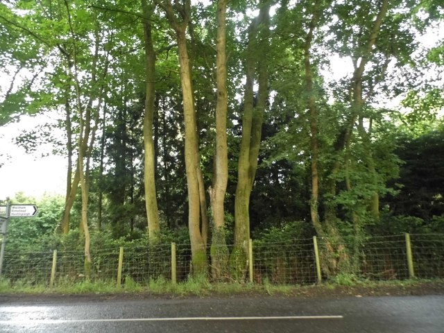
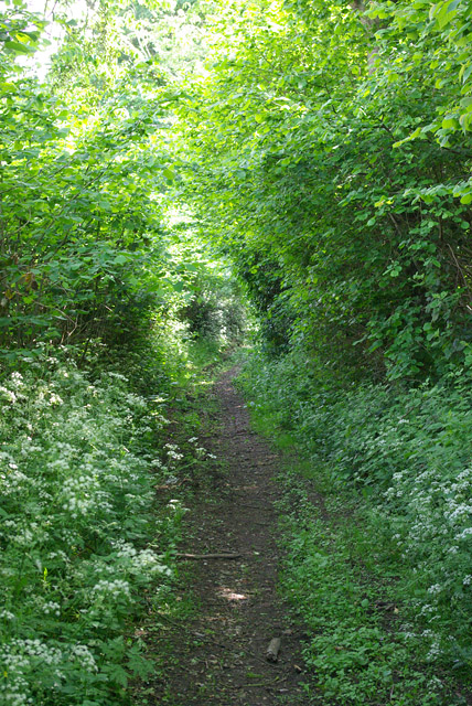
The wood is characterized by its diverse range of tree species, including oak, beech, and ash. The dense canopy created by these towering trees creates a tranquil and shaded environment, making it a popular destination for locals and nature enthusiasts alike. The forest floor is adorned with a variety of wildflowers and ferns, adding to the beauty and biodiversity of the woodland.

Hobday's Wood is home to a rich array of wildlife, providing a haven for many species. Birdwatchers can spot a multitude of bird species, including woodpeckers, owls, and various songbirds. Mammals such as deer, foxes, and rabbits can often be seen roaming through the undergrowth.

The wood offers a network of well-maintained footpaths and trails, allowing visitors to explore its natural wonders. A small stream meanders through the wood, adding to its charm and providing a peaceful spot for visitors to relax and enjoy the surroundings.

Hobday's Wood is a cherished natural treasure in Kent, attracting visitors throughout the year. Its beauty, tranquility, and rich biodiversity make it a delightful place for nature lovers to escape the hustle and bustle of everyday life and immerse themselves in the wonders of the woodland.

If you have any feedback on the listing, please let us know in the comments section below.

Hobday's Wood Images

Images are sourced within 2km of 51.205309/1.025808 or Grid Reference TR1149. Thanks to Geograph Open Source API. All images are credited.

Ansdore village Ansdore is a tiny farming community along this short dead end road. Behind this point is the private farm of Upper Ansdore which I did not venture into.
Ansdore village
Ansdore is a tiny farming community along this short dead end road. Behind this point is the private farm of Upper Ansdore which I did not venture into.
The road to Ansdore Off Duckpit Lane, this short track leads to the small collection of farms in Ansdore.
The road to Ansdore
Off Duckpit Lane, this short track leads to the small collection of farms in Ansdore.
Field in Ansdore
Field in Ansdore
The entrance to Springfield Farm, Ansdore
Duckpit Road, Ansdore
Fields by Duckpit Road
Richdore Road, Sole Street Like Minster, there are also two Sole Streets in Kent. This one is barely discernible and unlike the other one has no station.
Richdore Road, Sole Street
Like Minster, there are also two Sole Streets in Kent. This one is barely discernible and unlike the other one has no station.
Woodland by Waltham Road
Field near Frogs Hall A public footpath from the foreground gate goes to and through Cox Hill Wood at the far side of the field.
Field near Frogs Hall
A public footpath from the foreground gate goes to and through Cox Hill Wood at the far side of the field.
Field between Frogs Hall and Yew Tree Farm Looking towards Yew Tree Farm.
Field between Frogs Hall and Yew Tree Farm
Looking towards Yew Tree Farm.
Bridleway running south from Whiteacre Lane
Whiteacre Lane Heading nowhere in particular, but serving rural premises such as Whiteacre Farm.
Whiteacre Lane
Heading nowhere in particular, but serving rural premises such as Whiteacre Farm.
Field by Anvil Green Road
Gate and track, Dene Meadows Apart from the impressive gates, the rest of the establishment looks rather impermanent.
Gate and track, Dene Meadows
Apart from the impressive gates, the rest of the establishment looks rather impermanent.
Duckpit Road Heading north.
Duckpit Road
Heading north.
Ruin opposite Yockletts Farm Presumably once some sort of farm building. Maps indicate it has a benchmark on the side facing the road.
Ruin opposite Yockletts Farm
Presumably once some sort of farm building. Maps indicate it has a benchmark on the side facing the road.
Derelict farm building, Church Lane A similar image of the <a href="https://www.geograph.org.uk/photo/5563948">TR1247 : Ruin opposite Yockletts Farm</a>. This image of this <a href="https://www.geograph.org.uk/photo/1194754">TR1247 : Derelict building on Church Lane</a> shows how much it has deteriorated over the years.
Derelict farm building, Church Lane
A similar image of the TR1247 : Ruin opposite Yockletts Farm. This image of this TR1247 : Derelict building on Church Lane shows how much it has deteriorated over the years.
Show me another place!

Hobday's Wood is located at Grid Ref: TR1149 (Lat: 51.205309, Lng: 1.025808)

Administrative County: Kent

District: Canterbury

Police Authority: Kent

What 3 Words

///crossings.pizzeria.awards. Near Chartham, Kent

Related Wikis

Anvil Green

Anvil Green is a small settlement located near Waltham in Kent, England, about nine miles (14.4 km) north east of Ashford. == External links == Media...

Waltham, Kent

Waltham is a village and civil parish 7 miles (11 km) southwest of Canterbury in Kent, England. == History == The village was once associated with the...

Yockletts Bank

Yockletts Bank is a 25.4-hectare (63-acre) biological Site of Special Scientific Interest west of Stelling Minnis in Kent. It is managed by KWT and is...

Denge Wood

Denge Wood is a wood located 8 miles southwest of Canterbury in Kent, England. The wood is owned by the Forestry Commission and the Woodland Trust. Part...

Petham

Petham is a rural village and civil parish in the North Downs, five miles south of Canterbury in Kent, South East England. The village church is All Saints...

Stour Valley Walk

The Stour Valley Walk is a recreational walking route that follows the River Stour, through the Low Weald and Kent Downs, from its source at Lenham to...

Bossingham

Bossingham is a large hamlet in the parish of Upper Hardres and the district of the City of Canterbury, Kent, England. It is located about five miles...

Stelling Minnis

Stelling Minnis is a village and civil parish in the Folkestone and Hythe district in Kent, England. The village lies 13 kilometres (8 mi) to the south...

Nearby Amenities

Located within 500m of 51.205309,1.025808
Post Box
Postal Code: CT4
Ref: CT4 191
Source: survey
Lat/Long: 51.2091703/1.0248092
Power: pole
Lat/Long: 51.2035006/1.0192421
Power: pole
Lat/Long: 51.2044114/1.0190436
Power: pole
Lat/Long: 51.2049693/1.0188398
Power: pole
Lat/Long: 51.2056768/1.0194352
Power: pole
Lat/Long: 51.2072514/1.0207227
Power: pole
Lat/Long: 51.2080009/1.0213557
Power: pole
Lat/Long: 51.2087806/1.0219914
Power: pole
Lat/Long: 51.2064868/1.0201031
Power: pole
Lat/Long: 51.2062196/1.0209078
Power: pole
Lat/Long: 51.2059491/1.0217392
The data included in this document is from www.openstreetmap.org. The data is made available under ODbL.

Have you been to Hobday's Wood?

Leave your review of Hobday's Wood below (or comments, questions and feedback).