Rusthall Common

Wood, Forest in Kent Tunbridge Wells

England

Rusthall Common

Woodland Path through the Trees A path through the dense beech woodland of Sproud's Wood, south of Speldhurst in Kent.
Woodland Path through the Trees Credit: John P Reeves

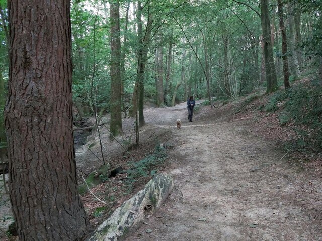
Rusthall Common is a picturesque woodland area located in the village of Rusthall, in the county of Kent, England. Covering an expansive area of approximately 250 acres, it is a place of natural beauty and tranquility. The common consists mainly of woodland, with a mix of broadleaf and coniferous trees, creating a diverse and vibrant ecosystem.

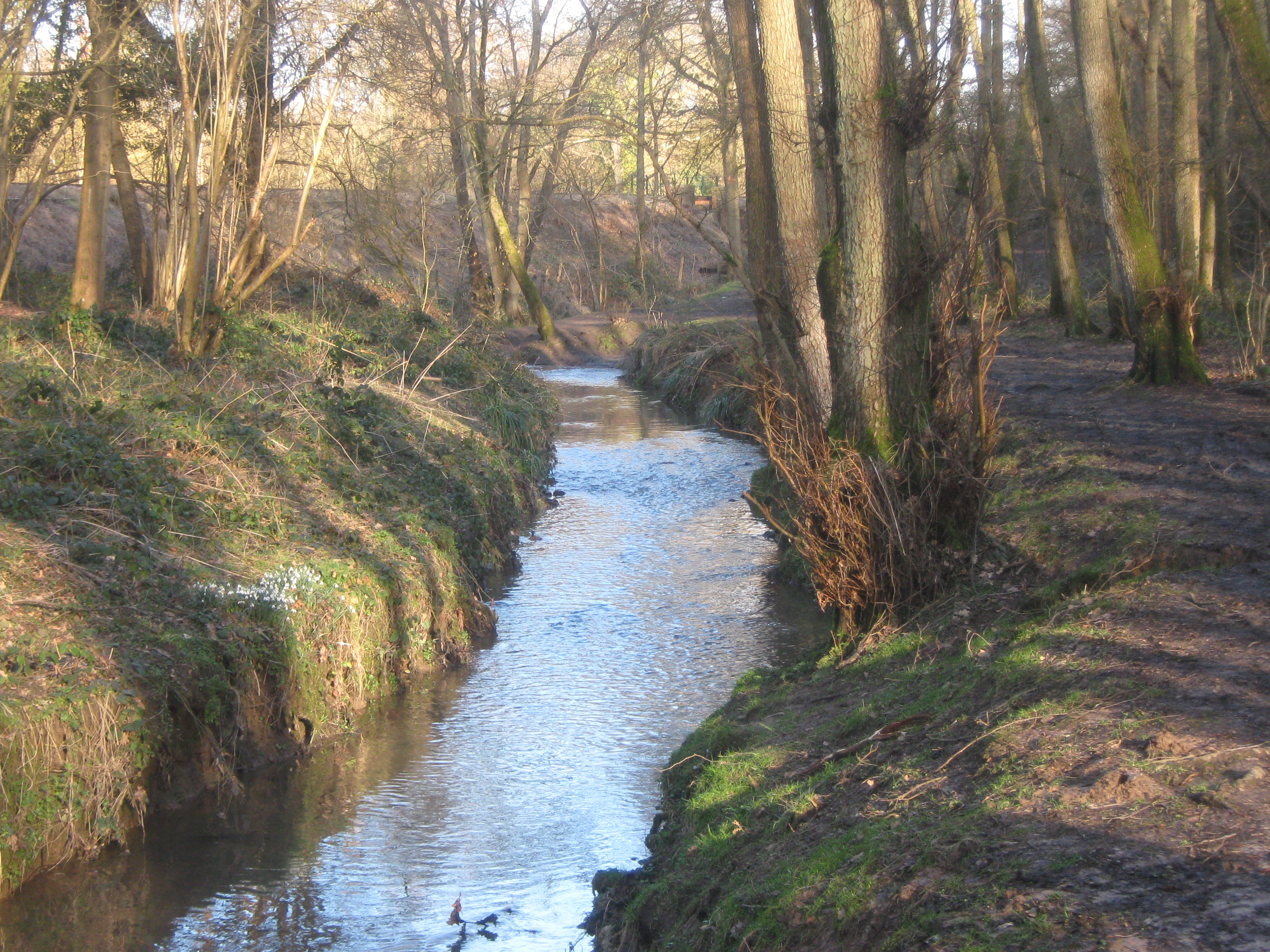
The common is a popular destination for nature enthusiasts, walkers, and families seeking a peaceful retreat from the bustling towns and cities. It offers a network of well-maintained footpaths, allowing visitors to explore the area and discover its hidden gems. These paths wind through the dense woodland, revealing scenic views, babbling streams, and an array of flora and fauna.

Rusthall Common is home to a variety of wildlife, including deer, badgers, foxes, and a multitude of bird species. It provides a habitat for many protected and endangered species, contributing to its importance as a nature conservation site.

In addition to its natural beauty, the common also boasts several recreational facilities. There are designated picnic areas, providing a perfect spot for families and friends to enjoy a leisurely lunch surrounded by nature. The common also features a children's play area, ensuring that younger visitors are well catered for.

Overall, Rusthall Common is a cherished natural haven in Kent, offering a peaceful escape into the heart of nature. Whether one is seeking a quiet walk, a family outing, or a chance to spot some wildlife, this woodland paradise is sure to leave visitors with lasting memories of tranquility and beauty.

If you have any feedback on the listing, please let us know in the comments section below.

Rusthall Common Images

Images are sourced within 2km of 51.132197/0.23501925 or Grid Reference TQ5639. Thanks to Geograph Open Source API. All images are credited.

Woodland Path through the Trees A path through the dense beech woodland of Sproud's Wood, south of Speldhurst in Kent.
Woodland Path through the Trees
A path through the dense beech woodland of Sproud's Wood, south of Speldhurst in Kent.
Footbridge over a Stream A wooden footpath over a stream in Shadwell Wood, south of Speldhurst in Kent on part of the Tunbridge Wells Circular Long Distance Footpath.
Footbridge over a Stream
A wooden footpath over a stream in Shadwell Wood, south of Speldhurst in Kent on part of the Tunbridge Wells Circular Long Distance Footpath.
Former Congregational Church Jabez Scholes may have been the original architect of this large Classical-style chapel, erected for £3,700 in 1845–48. The Tuscan portico at the front cost a further £1,400 in 1866. Acquired by Pentecostalists in 1977, it was sold three years later and turned into shops.At present occupied by Cotswold.
Grade II* listed. <span class="nowrap"><a title="http://www.britishlistedbuildings.co.uk/en-168097-lecture-hall-mount-pleasant-congregation" rel="nofollow ugc noopener" href="http://www.britishlistedbuildings.co.uk/en-168097-lecture-hall-mount-pleasant-congregation">Link</a><img style="margin-left:2px;" alt="External link" title="External link - shift click to open in new window" src="https://s1.geograph.org.uk/img/external.png" width="10" height="10"/></span>
Former Congregational Church
Jabez Scholes may have been the original architect of this large Classical-style chapel, erected for £3,700 in 1845–48. The Tuscan portico at the front cost a further £1,400 in 1866. Acquired by Pentecostalists in 1977, it was sold three years later and turned into shops.At present occupied by Cotswold. Grade II* listed. LinkExternal link
Vacant Site The three-screen cinema at the corner of Mount Pleasant Road and Church Road closed in October 2000, after a new multiplex opened on the edge of town. The building was built around 1934.  Previously the site was Belvedere House. 

Along with the adjoining shop buildings on Mount Pleasant Road and Church Road, the site had numerous planning applications and owners since it was disused in 2000, and the old buildings were finally demolished and cleared in 2014.

A new planning application for the site was submitted in July 2017. It includes retail and restaurant use, cinema, and 99 flats (Application ref 17/02262/FULL ).
Vacant Site
The three-screen cinema at the corner of Mount Pleasant Road and Church Road closed in October 2000, after a new multiplex opened on the edge of town. The building was built around 1934. Previously the site was Belvedere House. Along with the adjoining shop buildings on Mount Pleasant Road and Church Road, the site had numerous planning applications and owners since it was disused in 2000, and the old buildings were finally demolished and cleared in 2014. A new planning application for the site was submitted in July 2017. It includes retail and restaurant use, cinema, and 99 flats (Application ref 17/02262/FULL ).
Mount Pleasant Rd
Mount Pleasant Rd
Tunbridge Wells Station Tunbridge Wells Station was opened by the South Eastern Railway (SER) on 25th November 1846. It is on "the Hastings line" ( <a title="https://www.geograph.org.uk/snippet/2428" href="https://www.geograph.org.uk/snippet/2428">Link</a> ). The station is a cut station with access in both directions by tunnels, the Grove Tunnel from the south and the Wells Tunnel from the north.
The station has a regular service to both London Charing Cross and Hastings as well as shuttles to Tonbridge and some to London Bridge via Redhill.
A Grade II listed building. <span class="nowrap"><a title="http://www.britishlistedbuildings.co.uk/en-168166-tunbridge-wells-central-railway-station-" rel="nofollow ugc noopener" href="http://www.britishlistedbuildings.co.uk/en-168166-tunbridge-wells-central-railway-station-">Link</a><img style="margin-left:2px;" alt="External link" title="External link - shift click to open in new window" src="https://s1.geograph.org.uk/img/external.png" width="10" height="10"/></span>
Tunbridge Wells Station
Tunbridge Wells Station was opened by the South Eastern Railway (SER) on 25th November 1846. It is on "the Hastings line" ( Link ). The station is a cut station with access in both directions by tunnels, the Grove Tunnel from the south and the Wells Tunnel from the north. The station has a regular service to both London Charing Cross and Hastings as well as shuttles to Tonbridge and some to London Bridge via Redhill. A Grade II listed building. LinkExternal link
The Bedford
The Bedford
High St
High St
The White Bear
The White Bear
Zizzi, High St
Zizzi, High St
Church of King Charles the Martyr Built in 1676, as the first permanent building in Tunbridge Wells. 
A full history is at <span class="nowrap"><a title="http://kcmtw.org/heritage/history/" rel="nofollow ugc noopener" href="http://kcmtw.org/heritage/history/">Link</a><img style="margin-left:2px;" alt="External link" title="External link - shift click to open in new window" src="https://s1.geograph.org.uk/img/external.png" width="10" height="10"/></span> 
A Grade I listed building <span class="nowrap"><a title="http://www.britishlistedbuildings.co.uk/en-168037" rel="nofollow ugc noopener" href="http://www.britishlistedbuildings.co.uk/en-168037">Link</a><img style="margin-left:2px;" alt="External link" title="External link - shift click to open in new window" src="https://s1.geograph.org.uk/img/external.png" width="10" height="10"/></span>
Church of King Charles the Martyr
Built in 1676, as the first permanent building in Tunbridge Wells. A full history is at LinkExternal link A Grade I listed building LinkExternal link
The Pantiles The Pantiles is the most famous street in Tunbridge Wells. It was originally a grove of trees until the Chalybeate spring was discovered in 1606. It rapidly developed into the hub of the new spa town. The street has over 40 listed buildings on it.
The Pantiles and Tunbridge Wells itself, owe their beginnings to the discovery of the Chalybeate Spring in the early 17th century and the popularity of the spa water amongst the gentry and royalty of Georgian England. As Tunbridge Wells grew in popularity as a spa resort, so did the area surrounding the Spring - eventually leading to the building of the colonnaded walkway in the 18th century, later known as The Pantiles. 
In its heyday in Georgian times, the 'Walks' as they were then known, were the place to see and be seen for visitors to Tunbridge Wells. A strict protocol was adhered to - gentry on the 'Upper Walks', the colonnade, and everyone else on the 'Lower Walks'. Richard Beau Nash, a dandy of the day made it his business to ensure that this protocol was adhered to by acting as a kind of Master of Ceremonies during 'the season' in Tunbridge Wells and in the town's rival, Bath. Things are much more relaxed nowadays and the Pantiles is now a very attractive and stylish part of Royal Tunbridge Wells.
Much of the colonnade has been renewed since its beginnings in the 17th century but most of the surrounding buildings date from the 18th and 19th centuries.
The tiled surface is Grade II listed. <span class="nowrap"><a title="https://historicengland.org.uk/listing/the-list/list-entry/1084405" rel="nofollow ugc noopener" href="https://historicengland.org.uk/listing/the-list/list-entry/1084405">Link</a><img style="margin-left:2px;" alt="External link" title="External link - shift click to open in new window" src="https://s1.geograph.org.uk/img/external.png" width="10" height="10"/></span>
The Pantiles
The Pantiles is the most famous street in Tunbridge Wells. It was originally a grove of trees until the Chalybeate spring was discovered in 1606. It rapidly developed into the hub of the new spa town. The street has over 40 listed buildings on it. The Pantiles and Tunbridge Wells itself, owe their beginnings to the discovery of the Chalybeate Spring in the early 17th century and the popularity of the spa water amongst the gentry and royalty of Georgian England. As Tunbridge Wells grew in popularity as a spa resort, so did the area surrounding the Spring - eventually leading to the building of the colonnaded walkway in the 18th century, later known as The Pantiles. In its heyday in Georgian times, the 'Walks' as they were then known, were the place to see and be seen for visitors to Tunbridge Wells. A strict protocol was adhered to - gentry on the 'Upper Walks', the colonnade, and everyone else on the 'Lower Walks'. Richard Beau Nash, a dandy of the day made it his business to ensure that this protocol was adhered to by acting as a kind of Master of Ceremonies during 'the season' in Tunbridge Wells and in the town's rival, Bath. Things are much more relaxed nowadays and the Pantiles is now a very attractive and stylish part of Royal Tunbridge Wells. Much of the colonnade has been renewed since its beginnings in the 17th century but most of the surrounding buildings date from the 18th and 19th centuries. The tiled surface is Grade II listed. LinkExternal link
Bath House The Pantiles is the most famous street in Tunbridge Wells. It was originally a grove of trees until the Chalybeate spring was discovered in 1606. It rapidly developed into the hub of the new spa town. The street has over 40 listed buildings on it.
The Pantiles and Tunbridge Wells itself, owe their beginnings to the discovery of the Chalybeate Spring in the early 17th century and the popularity of the spa water amongst the gentry and royalty of Georgian England. As Tunbridge Wells grew in popularity as a spa resort, so did the area surrounding the Spring - eventually leading to the building of the colonnaded walkway in the 18th century, later known as The Pantiles. 
In its heyday in Georgian times, the 'Walks' as they were then known, were the place to see and be seen for visitors to Tunbridge Wells. A strict protocol was adhered to - gentry on the 'Upper Walks', the colonnade, and everyone else on the 'Lower Walks'. Richard Beau Nash, a dandy of the day made it his business to ensure that this protocol was adhered to by acting as a kind of Master of Ceremonies during 'the season' in Tunbridge Wells and in the town's rival, Bath. Things are much more relaxed nowadays and the Pantiles is now a very attractive and stylish part of Royal Tunbridge Wells.
Much of the colonnade has been renewed since its beginnings in the 17th century but most of the surrounding buildings date from the 18th and 19th centuries.
The tiled surface is Grade II listed. <span class="nowrap"><a title="https://historicengland.org.uk/listing/the-list/list-entry/1084405" rel="nofollow ugc noopener" href="https://historicengland.org.uk/listing/the-list/list-entry/1084405">Link</a><img style="margin-left:2px;" alt="External link" title="External link - shift click to open in new window" src="https://s1.geograph.org.uk/img/external.png" width="10" height="10"/></span>
Bath House
The Pantiles is the most famous street in Tunbridge Wells. It was originally a grove of trees until the Chalybeate spring was discovered in 1606. It rapidly developed into the hub of the new spa town. The street has over 40 listed buildings on it. The Pantiles and Tunbridge Wells itself, owe their beginnings to the discovery of the Chalybeate Spring in the early 17th century and the popularity of the spa water amongst the gentry and royalty of Georgian England. As Tunbridge Wells grew in popularity as a spa resort, so did the area surrounding the Spring - eventually leading to the building of the colonnaded walkway in the 18th century, later known as The Pantiles. In its heyday in Georgian times, the 'Walks' as they were then known, were the place to see and be seen for visitors to Tunbridge Wells. A strict protocol was adhered to - gentry on the 'Upper Walks', the colonnade, and everyone else on the 'Lower Walks'. Richard Beau Nash, a dandy of the day made it his business to ensure that this protocol was adhered to by acting as a kind of Master of Ceremonies during 'the season' in Tunbridge Wells and in the town's rival, Bath. Things are much more relaxed nowadays and the Pantiles is now a very attractive and stylish part of Royal Tunbridge Wells. Much of the colonnade has been renewed since its beginnings in the 17th century but most of the surrounding buildings date from the 18th and 19th centuries. The tiled surface is Grade II listed. LinkExternal link
The Forum The Forum is an independent music venue in Royal Tunbridge Wells with a standing capacity of 250. The Forum opened in 1993.
The building was built in 1939 as rest rooms for visitors to The Common.
Wikipedia: <span class="nowrap"><a title="https://en.wikipedia.org/wiki/Tunbridge_Wells_Forum" rel="nofollow ugc noopener" href="https://en.wikipedia.org/wiki/Tunbridge_Wells_Forum">Link</a><img style="margin-left:2px;" alt="External link" title="External link - shift click to open in new window" src="https://s1.geograph.org.uk/img/external.png" width="10" height="10"/></span>
The Forum
The Forum is an independent music venue in Royal Tunbridge Wells with a standing capacity of 250. The Forum opened in 1993. The building was built in 1939 as rest rooms for visitors to The Common. Wikipedia: LinkExternal link
Frog Lane Frog Lane is one of the oldest streets in Tunbridge Wells. It is located in the Mount Sion area of town. The surface of the lane is Grade II listed. <span class="nowrap"><a title="http://www.britishlistedbuildings.co.uk/en-167989-granite-surface-to-frog-lane-kent" rel="nofollow ugc noopener" href="http://www.britishlistedbuildings.co.uk/en-167989-granite-surface-to-frog-lane-kent">Link</a><img style="margin-left:2px;" alt="External link" title="External link - shift click to open in new window" src="https://s1.geograph.org.uk/img/external.png" width="10" height="10"/></span>
Frog Lane
Frog Lane is one of the oldest streets in Tunbridge Wells. It is located in the Mount Sion area of town. The surface of the lane is Grade II listed. LinkExternal link
The Range The Range is a home, leisure and garden retailer, with over 130 stores around the country.
Website: <span class="nowrap"><a title="https://www.therange.co.uk/" rel="nofollow ugc noopener" href="https://www.therange.co.uk/">Link</a><img style="margin-left:2px;" alt="External link" title="External link - shift click to open in new window" src="https://s1.geograph.org.uk/img/external.png" width="10" height="10"/></span>
The Range
The Range is a home, leisure and garden retailer, with over 130 stores around the country. Website: LinkExternal link
Moss Bros Moss Bros Group PLC is a public limited company set up in 1851 by Moses Moss in Covent Garden, London, UK. One of the UK's top menswear stores, specialising in dress wear for formal occasions, Moss Bros has over 150 stores throughout the United Kingdom.
Moss Bros
Moss Bros Group PLC is a public limited company set up in 1851 by Moses Moss in Covent Garden, London, UK. One of the UK's top menswear stores, specialising in dress wear for formal occasions, Moss Bros has over 150 stores throughout the United Kingdom.
Show me another place!

Rusthall Common is located at Grid Ref: TQ5639 (Lat: 51.132197, Lng: 0.23501925)

Administrative County: Kent

District: Tunbridge Wells

Police Authority: Kent

What 3 Words

///under.tinned.tissue. Near Rusthall, Kent

Related Wikis

Rusthall

Rusthall is a village located approximately 2 miles to the west of the spa town of Tunbridge Wells in Kent. The village grew up around a large property...

St Paul's Church, Rusthall

St Paul's Church is a Church of England parish church in Rusthall, Kent, England. It is a Grade II listed building. == History == St Paul's Church was...
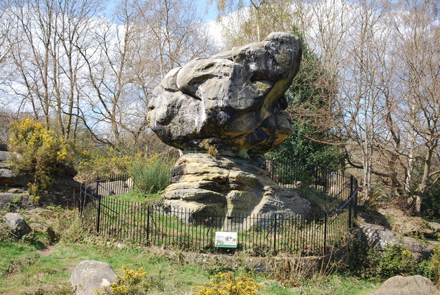
Rusthall Common

Rusthall Common is a 2.7-hectare (6.7-acre) geological Site of Special Scientific Interest in Rusthall, a suburb of Tunbridge Wells in Kent. It is a Geological...

Spa Valley Railway

The Spa Valley Railway (SVR) is a standard gauge heritage railway in England that runs from Tunbridge Wells West railway station in Tunbridge Wells to...

Friezland Wood

Friezland Wood is a woodland in Kent, England, near Tunbridge Wells. It covers a total area of 7.69 hectares (19.00 acres). It is owned and managed by...

Rusthall F.C.

Rusthall FC is an English football club located in Rusthall, near Royal Tunbridge Wells, in Kent. The club plays in the Southern Counties East League Premier...
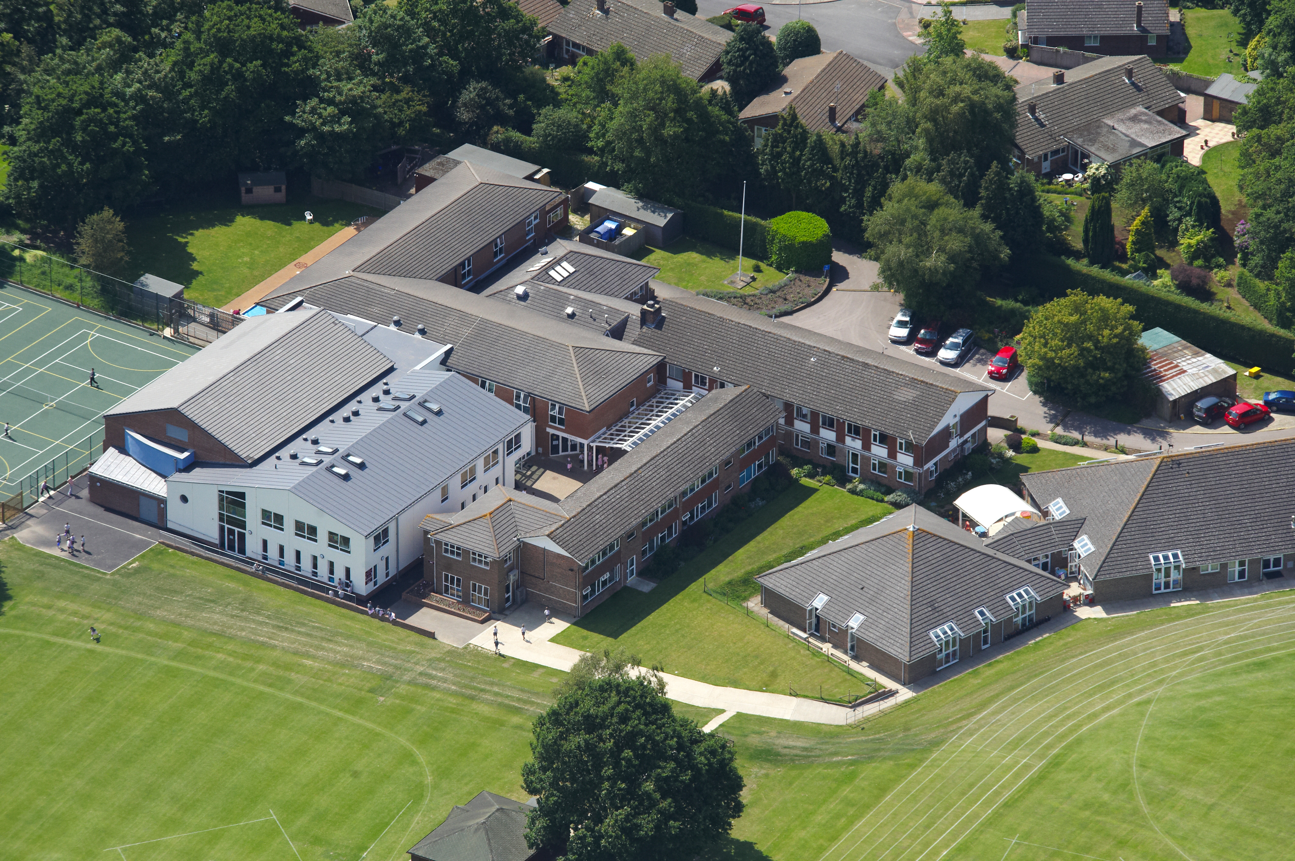
Rose Hill School

Rose Hill School is a co-educational preparatory school in Royal Tunbridge Wells, Kent, England. It is a member of the Independent Association of Preparatory...

High Rocks railway station

High Rocks railway station is a station on the Spa Valley Railway in High Rocks, East Sussex, England. The original High Rocks Halt opened on 1 June 1907...

Nearby Amenities

Located within 500m of 51.132197,0.23501925
Pub
Toad Rock Retreat
Lat/Long: 51.1346175/0.2398078
Bus Stop
Rusthall High Street
Naptan AtcoCode: 2400A007890A
Naptan Bearing: SE
Naptan CommonName: Rusthall High Street
Naptan Indicator: SE-bound
Naptan Landmark: Common View
Naptan NaptanCode: kntajpgt
Naptan PlusbusZoneRef: TUNWELL
Naptan Street: Rusthall High St
Naptan Verified: no
Source: naptan_import
Lat/Long: 51.1351314/0.2309396
Bus Stop
Church
Naptan AtcoCode: 2400A007900A
Naptan Bearing: E
Naptan CommonName: Church
Naptan Indicator: E-bound
Naptan Landmark: O/S Ch
Naptan NaptanCode: kntajpgw
Naptan PlusbusZoneRef: TUNWELL
Naptan Street: Rusthall Rd
Naptan Verified: no
Public Transport: platform
Source: naptan_import
Lat/Long: 51.1322602/0.2370357
Bus Stop
Harmony Street
Naptan AtcoCode: 2400A035120A
Naptan Bearing: NW
Naptan CommonName: Harmony Street
Naptan Indicator: opp
Naptan Landmark: Harmony Street
Naptan NaptanCode: kntdmgpj
Naptan PlusbusZoneRef: TUNWELL
Naptan Street: Rusthall Rd
Naptan Verified: no
Source: naptan_import
Lat/Long: 51.132205/0.240659
Bus Stop
Harmony Street
Naptan AtcoCode: 2400A035130A
Naptan Bearing: SE
Naptan CommonName: Harmony Street
Naptan Indicator: adj
Naptan Landmark: Harmony Street
Naptan NaptanCode: kntdmgpm
Naptan PlusbusZoneRef: TUNWELL
Naptan Street: Rusthall Rd
Naptan Verified: no
Source: naptan_import
Lat/Long: 51.1321882/0.2409862
Crossing
Crossing: unmarked
Crossing Island: no
Tactile Paving: yes
Lat/Long: 51.1308334/0.2416749
Pub
White Hart
Lat/Long: 51.1354009/0.2326885
Turning Circle
Lat/Long: 51.1362351/0.2376908
Restaurant
The Beacon
Source: local_knowledge
Lat/Long: 51.1302538/0.2318315
Mini Roundabout
Direction: clockwise
Lat/Long: 51.1280337/0.2375605
Post Box
Operator: Royal Mail
Post Box Type: pillar
Ref: TN4 31D
Royal Cypher: VR
Royal Cypher Wikidata: Q33102356
Lat/Long: 51.1344355/0.2355019
Bus Stop
Rusthall High Street
Lat/Long: 51.135165/0.2304944
Bus Stop
Rusthall Grange
Lat/Long: 51.1344747/0.2366598
Bus Stop
Rusthall Grange
Lat/Long: 51.1344109/0.2369688
Parking
Capacity: 4
Fee: no
Parking: lane
Lat/Long: 51.1330118/0.2333835
Community Centre
Sunnyside Community Hall
Lat/Long: 51.1346649/0.2338867
Bench
Backrest: yes
Lat/Long: 51.1337756/0.2403125
Board Type: geology
Information: board
Tourism: information
Lat/Long: 51.1338482/0.2399763
Bench
Backrest: yes
Lat/Long: 51.1308576/0.2418467
Waste Basket
Lat/Long: 51.1334537/0.2351774
Generator Method: photovoltaic
Generator Output Electricity: yes
Generator Source: solar
Generator Type: solar_photovoltaic_panel
Location: roof
Power: generator
Lat/Long: 51.1335448/0.2293423
Generator Method: photovoltaic
Generator Output Electricity: yes
Generator Source: solar
Generator Type: solar_photovoltaic_panel
Location: roof
Power: generator
Lat/Long: 51.1362344/0.234755
Generator Method: photovoltaic
Generator Output Electricity: yes
Generator Source: solar
Generator Type: solar_photovoltaic_panel
Location: roof
Power: generator
Lat/Long: 51.1363118/0.2351385
Generator Method: photovoltaic
Generator Output Electricity: yes
Generator Source: solar
Generator Type: solar_photovoltaic_panel
Location: roof
Power: generator
Lat/Long: 51.136332/0.2360143
Generator Method: photovoltaic
Generator Output Electricity: yes
Generator Source: solar
Generator Type: solar_photovoltaic_panel
Location: roof
Power: generator
Lat/Long: 51.1364641/0.2359432
Generator Method: photovoltaic
Generator Output Electricity: yes
Generator Source: solar
Generator Type: solar_photovoltaic_panel
Location: roof
Power: generator
Lat/Long: 51.1364153/0.2359754
Generator Method: photovoltaic
Generator Output Electricity: yes
Generator Source: solar
Generator Type: solar_photovoltaic_panel
Location: roof
Power: generator
Lat/Long: 51.1363665/0.2359955
Generator Method: photovoltaic
Generator Output Electricity: yes
Generator Source: solar
Generator Type: solar_photovoltaic_panel
Location: roof
Power: generator
Lat/Long: 51.1360425/0.2339892
Generator Method: photovoltaic
Generator Output Electricity: yes
Generator Source: solar
Generator Type: solar_photovoltaic_panel
Location: roof
Power: generator
Lat/Long: 51.136056/0.2340616
Generator Method: photovoltaic
Generator Output Electricity: yes
Generator Source: solar
Generator Type: solar_photovoltaic_panel
Location: roof
Power: generator
Lat/Long: 51.1360677/0.234122
Generator Method: photovoltaic
Generator Output Electricity: yes
Generator Source: solar
Generator Type: solar_photovoltaic_panel
Location: roof
Power: generator
Lat/Long: 51.1360829/0.2342212
Generator Method: photovoltaic
Generator Output Electricity: yes
Generator Source: solar
Generator Type: solar_photovoltaic_panel
Location: roof
Power: generator
Lat/Long: 51.1360947/0.234291
Generator Method: photovoltaic
Generator Output Electricity: yes
Generator Source: solar
Generator Type: solar_photovoltaic_panel
Location: roof
Power: generator
Lat/Long: 51.1361098/0.2343526
Generator Method: photovoltaic
Generator Output Electricity: yes
Generator Source: solar
Generator Type: solar_photovoltaic_panel
Location: roof
Power: generator
Lat/Long: 51.1361216/0.2344626
Generator Method: photovoltaic
Generator Output Electricity: yes
Generator Source: solar
Generator Type: solar_photovoltaic_panel
Location: roof
Power: generator
Lat/Long: 51.1361418/0.2345136
Generator Method: photovoltaic
Generator Output Electricity: yes
Generator Source: solar
Generator Type: solar_photovoltaic_panel
Location: roof
Power: generator
Lat/Long: 51.1361519/0.2345806
Generator Method: photovoltaic
Generator Output Electricity: yes
Generator Source: solar
Generator Type: solar_photovoltaic_panel
Location: roof
Power: generator
Lat/Long: 51.1361822/0.234645
Generator Method: photovoltaic
Generator Output Electricity: yes
Generator Source: solar
Generator Type: solar_photovoltaic_panel
Location: roof
Power: generator
Lat/Long: 51.1362966/0.2354631
Generator Method: photovoltaic
Generator Output Electricity: yes
Generator Source: solar
Generator Type: solar_photovoltaic_panel
Location: roof
Power: generator
Lat/Long: 51.1363118/0.2355221
Generator Method: photovoltaic
Generator Output Electricity: yes
Generator Source: solar
Generator Type: solar_photovoltaic_panel
Location: roof
Power: generator
Lat/Long: 51.1363151/0.2355784
Generator Method: photovoltaic
Generator Output Electricity: yes
Generator Source: solar
Generator Type: solar_photovoltaic_panel
Location: roof
Power: generator
Lat/Long: 51.136337/0.2356938
Generator Method: photovoltaic
Generator Output Electricity: yes
Generator Source: solar
Generator Type: solar_photovoltaic_panel
Location: roof
Power: generator
Lat/Long: 51.1363471/0.2357554
Generator Method: photovoltaic
Generator Output Electricity: yes
Generator Source: solar
Generator Type: solar_photovoltaic_panel
Location: roof
Power: generator
Lat/Long: 51.1352565/0.235852
Generator Method: photovoltaic
Generator Output Electricity: yes
Generator Source: solar
Generator Type: solar_photovoltaic_panel
Location: roof
Power: generator
Lat/Long: 51.1352178/0.2397922
The data included in this document is from www.openstreetmap.org. The data is made available under ODbL.

Have you been to Rusthall Common?

Leave your review of Rusthall Common below (or comments, questions and feedback).