Fannfield Wood

Wood, Forest in Essex

England

Fannfield Wood

Elm Park Avenue
Elm Park Avenue Credit: N Chadwick

Fannfield Wood is a picturesque woodland located in Essex, England. Covering an area of approximately 20 hectares, this woodland is considered a hidden gem for nature enthusiasts and outdoor lovers. The wood is situated near the village of Fannfield, which gives it its name.

Fannfield Wood is predominantly composed of oak and beech trees, creating a stunning canopy that provides shade and shelter for an abundance of wildlife. The woodland floor is covered with a rich carpet of bluebells in the spring, creating a breathtaking sight for visitors.

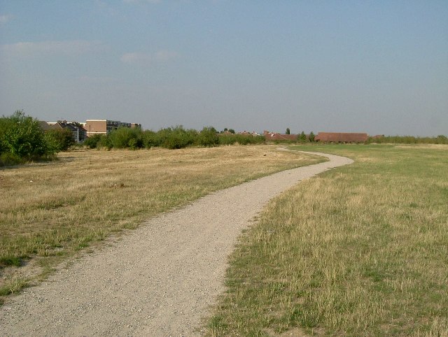
The wood is crisscrossed by a network of well-maintained footpaths, offering visitors the opportunity to explore its beauty at their own pace. These paths lead visitors through a varied landscape, including open glades, dense woodland, and babbling brooks. Along the way, visitors may encounter a diverse range of flora and fauna, including wildflowers, ferns, and various species of birds.

Fannfield Wood is also home to a range of wildlife, including deer, badgers, and foxes. The peaceful atmosphere and natural beauty of the wood make it an ideal spot for birdwatching, as many rare and migratory birds can be spotted throughout the year.

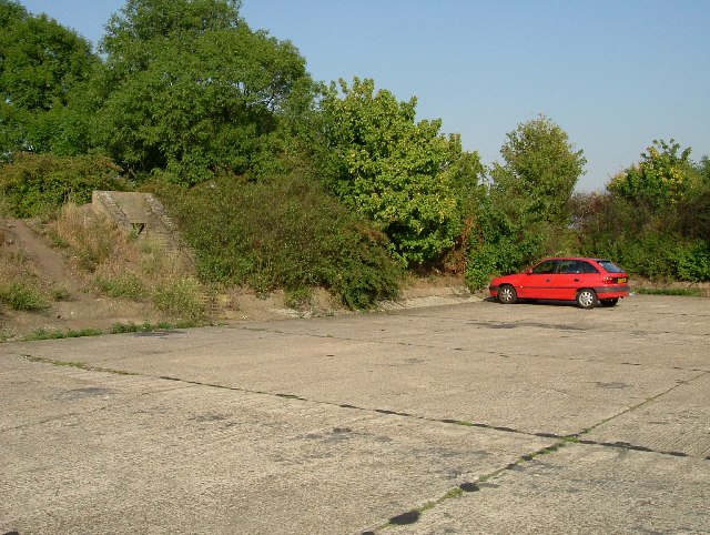
The wood is easily accessible, with a small car park available for visitors. There are also picnic areas dotted around the wood, allowing visitors to relax and enjoy a meal amidst the tranquil surroundings.

Overall, Fannfield Wood offers a serene and enchanting escape from the hustle and bustle of everyday life, providing a haven for nature lovers and those seeking solace in the great outdoors.

If you have any feedback on the listing, please let us know in the comments section below.

Fannfield Wood Images

Images are sourced within 2km of 51.533629/0.205475 or Grid Reference TQ5383. Thanks to Geograph Open Source API. All images are credited.

Elm Park Avenue
Elm Park Avenue
Roundabout, Elm Park Avenue A few years ago I read a book by Mark Mason "Walking the lines" in which he walked the route of the London Underground lines, overground. I will repeat this visiting all 272 stations (some more than once). My route tries to follow the line of the railway as closely as possible, using footpaths and roads, deviations are made to make the walk more "interesting".
Roundabout, Elm Park Avenue
A few years ago I read a book by Mark Mason "Walking the lines" in which he walked the route of the London Underground lines, overground. I will repeat this visiting all 272 stations (some more than once). My route tries to follow the line of the railway as closely as possible, using footpaths and roads, deviations are made to make the walk more "interesting".
Elm Park Station Elm Park is a London Underground station serving Elm Park in  Havering, east London. It is on the District line between Dagenham East and Hornchurch. It is 4 kilometres along the line from the eastern terminus at Upminster.
The station was opened on 13 May 1935 by the London, Midland and Scottish Railway on the local electrified tracks between Upminster and Barking that were constructed in 1932.
Wikipedia: <span class="nowrap"><a title="https://en.wikipedia.org/wiki/Elm_Park_tube_station" rel="nofollow ugc noopener" href="https://en.wikipedia.org/wiki/Elm_Park_tube_station">Link</a><img style="margin-left:2px;" alt="External link" title="External link - shift click to open in new window" src="https://s1.geograph.org.uk/img/external.png" width="10" height="10"/></span>
Elm Park Station
Elm Park is a London Underground station serving Elm Park in Havering, east London. It is on the District line between Dagenham East and Hornchurch. It is 4 kilometres along the line from the eastern terminus at Upminster. The station was opened on 13 May 1935 by the London, Midland and Scottish Railway on the local electrified tracks between Upminster and Barking that were constructed in 1932. Wikipedia: LinkExternal link
District line and C2C line
Elm Park Station Elm Park is a London Underground station serving Elm Park in  Havering, east London. It is on the District line between Dagenham East and Hornchurch. It is 4 kilometres along the line from the eastern terminus at Upminster.
The station was opened on 13 May 1935 by the London, Midland and Scottish Railway on the local electrified tracks between Upminster and Barking that were constructed in 1932.
Wikipedia: <span class="nowrap"><a title="https://en.wikipedia.org/wiki/Elm_Park_tube_station" rel="nofollow ugc noopener" href="https://en.wikipedia.org/wiki/Elm_Park_tube_station">Link</a><img style="margin-left:2px;" alt="External link" title="External link - shift click to open in new window" src="https://s1.geograph.org.uk/img/external.png" width="10" height="10"/></span>
Elm Park Station
Elm Park is a London Underground station serving Elm Park in Havering, east London. It is on the District line between Dagenham East and Hornchurch. It is 4 kilometres along the line from the eastern terminus at Upminster. The station was opened on 13 May 1935 by the London, Midland and Scottish Railway on the local electrified tracks between Upminster and Barking that were constructed in 1932. Wikipedia: LinkExternal link
Labyrinth #79, Elm Park Elm Park is a London Underground station serving Elm Park in  Havering, east London. It is on the District line between Dagenham East and Hornchurch. It is 4 kilometres along the line from the eastern terminus at Upminster.
The station was opened on 13 May 1935 by the London, Midland and Scottish Railway on the local electrified tracks between Upminster and Barking that were constructed in 1932.
Wikipedia: <span class="nowrap"><a title="https://en.wikipedia.org/wiki/Elm_Park_tube_station" rel="nofollow ugc noopener" href="https://en.wikipedia.org/wiki/Elm_Park_tube_station">Link</a><img style="margin-left:2px;" alt="External link" title="External link - shift click to open in new window" src="https://s1.geograph.org.uk/img/external.png" width="10" height="10"/></span>
Labyrinth #79, Elm Park
Elm Park is a London Underground station serving Elm Park in Havering, east London. It is on the District line between Dagenham East and Hornchurch. It is 4 kilometres along the line from the eastern terminus at Upminster. The station was opened on 13 May 1935 by the London, Midland and Scottish Railway on the local electrified tracks between Upminster and Barking that were constructed in 1932. Wikipedia: LinkExternal link
Elm Park Station Elm Park is a London Underground station serving Elm Park in  Havering, east London. It is on the District line between Dagenham East and Hornchurch. It is 4 kilometres along the line from the eastern terminus at Upminster.
The station was opened on 13 May 1935 by the London, Midland and Scottish Railway on the local electrified tracks between Upminster and Barking that were constructed in 1932.
Wikipedia: <span class="nowrap"><a title="https://en.wikipedia.org/wiki/Elm_Park_tube_station" rel="nofollow ugc noopener" href="https://en.wikipedia.org/wiki/Elm_Park_tube_station">Link</a><img style="margin-left:2px;" alt="External link" title="External link - shift click to open in new window" src="https://s1.geograph.org.uk/img/external.png" width="10" height="10"/></span>
Elm Park Station
Elm Park is a London Underground station serving Elm Park in Havering, east London. It is on the District line between Dagenham East and Hornchurch. It is 4 kilometres along the line from the eastern terminus at Upminster. The station was opened on 13 May 1935 by the London, Midland and Scottish Railway on the local electrified tracks between Upminster and Barking that were constructed in 1932. Wikipedia: LinkExternal link
Elm Park Avenue A few years ago I read a book by Mark Mason "Walking the lines" in which he walked the route of the London Underground lines, overground. I will repeat this visiting all 272 stations (some more than once). My route tries to follow the line of the railway as closely as possible, using footpaths and roads, deviations are made to make the walk more "interesting".
Elm Park Avenue
A few years ago I read a book by Mark Mason "Walking the lines" in which he walked the route of the London Underground lines, overground. I will repeat this visiting all 272 stations (some more than once). My route tries to follow the line of the railway as closely as possible, using footpaths and roads, deviations are made to make the walk more "interesting".
New Road, Rainham The flats were completed in 2022.
New Road, Rainham
The flats were completed in 2022.
Knightswood Place on New Road, Rainham This replaced an industrial area.
Knightswood Place on New Road, Rainham
This replaced an industrial area.
Old Boundary Marker on Kilmartin Way, Hornchurch Air Ministry Boundary Marker against the garden fence of No.87 Wood Lane or the northwest side of the junction with Kilmartin Way, Hornchurch. The Air Ministry existed from 1918 to 1964. RAF Hornchurch closed in 1962.

Milestone Society National ID: EX_AMHORN01em
Old Boundary Marker on Kilmartin Way, Hornchurch
Air Ministry Boundary Marker against the garden fence of No.87 Wood Lane or the northwest side of the junction with Kilmartin Way, Hornchurch. The Air Ministry existed from 1918 to 1964. RAF Hornchurch closed in 1962. Milestone Society National ID: EX_AMHORN01em
High Rise Living New Plymouth House with Napier House in the background built in the early 1960's they are located on Dunedin Road on the "New Zealand" estate in Rainham.
High Rise Living
New Plymouth House with Napier House in the background built in the early 1960's they are located on Dunedin Road on the "New Zealand" estate in Rainham.
Bretons House This grand house is now the visitor centre of the Bretons outdoor activity centre
Bretons House
This grand house is now the visitor centre of the Bretons outdoor activity centre
Post Office The Post Office in Cherry Tree lane Rainham
Post Office
The Post Office in Cherry Tree lane Rainham
The London Loop A new footpath, part of the London Loop to the south of the Hornchurch Country Park. Picture was taken looking north.
The London Loop
A new footpath, part of the London Loop to the south of the Hornchurch Country Park. Picture was taken looking north.
The Road to Hell? A pub on South End Road serving the residents of the "Airfield Estate". The road to hell was paved with the good intent of Flying Officer Raimund Sanders-Draper an American airman posted to RAF Hornchurch. His exploits were the subject of a Musical Play produced at the Queens Theatre in Hornchurch in 2003. Sanders-Draper was killed in 1943 during a crash landing, he stayed with his stricken aircraft so he could avoid crashing into the local school,  he had sufficient height to bail out but chose to save the children. The school in Suttons Lane was renamed Sanders-Draper in his honour.
The Road to Hell?
A pub on South End Road serving the residents of the "Airfield Estate". The road to hell was paved with the good intent of Flying Officer Raimund Sanders-Draper an American airman posted to RAF Hornchurch. His exploits were the subject of a Musical Play produced at the Queens Theatre in Hornchurch in 2003. Sanders-Draper was killed in 1943 during a crash landing, he stayed with his stricken aircraft so he could avoid crashing into the local school, he had sufficient height to bail out but chose to save the children. The school in Suttons Lane was renamed Sanders-Draper in his honour.
Swords into Ploughshares One of the few parts of the old RAF Hornchurch that have survived. The concrete aircraft dispersal is surrounded with an air raid shelter in the blast protection mound, is now used as a car park for the country park. RAF Hornchurch opened in 1917 as Suttons Farm but closed at the end of WW1. A new station was opened in 1928. Spitfires from Hornchurch took part in the infamous Battle of Barking Creek in late 1939 when two Hurricanes from RAF North Weald were shot down, one of the pilots was killed <span class="nowrap"><a title="http://en.wikipedia.org/wiki/Battle_of_Barking_Creek" rel="nofollow ugc noopener" href="http://en.wikipedia.org/wiki/Battle_of_Barking_Creek">Link</a><img style="margin-left:2px;" alt="External link" title="External link - shift click to open in new window" src="https://s1.geograph.org.uk/img/external.png" width="10" height="10"/></span>. Hornchurch was a one of the most important of 11 Group's Sector stations during the Battle of Britain. It remained an RAF fighter station until spring of 1945. From 1952-62 it was the Aircrew selection centre it finally closed in 1963. Much of the airfield was built over but there are some relics in the country park. You can see some unusual airfield defences at <a href="https://www.geograph.org.uk/photo/168505">TQ5384 : Tett Turrets</a>. To go to the next field in an alphabetical tour of Essex WW2 airfields click on 
<a href="https://www.geograph.org.uk/photo/221842">TL5543 : RAF Little Walden</a>. Much information was gleaned from Graham Smith’s book “Essex Airfields In The Second World <span class="nowrap"><a title="https://books.google.co.uk/books/about/Essex_Airfields_in_the_Second_World_War.html?id=u3atAAAACAAJ&redir_esc=y" rel="nofollow ugc noopener" href="https://books.google.co.uk/books/about/Essex_Airfields_in_the_Second_World_War.html?id=u3atAAAACAAJ&redir_esc=y">Link</a><img style="margin-left:2px;" alt="External link" title="External link - shift click to open in new window" src="https://s1.geograph.org.uk/img/external.png" width="10" height="10"/></span>
Swords into Ploughshares
One of the few parts of the old RAF Hornchurch that have survived. The concrete aircraft dispersal is surrounded with an air raid shelter in the blast protection mound, is now used as a car park for the country park. RAF Hornchurch opened in 1917 as Suttons Farm but closed at the end of WW1. A new station was opened in 1928. Spitfires from Hornchurch took part in the infamous Battle of Barking Creek in late 1939 when two Hurricanes from RAF North Weald were shot down, one of the pilots was killed LinkExternal link. Hornchurch was a one of the most important of 11 Group's Sector stations during the Battle of Britain. It remained an RAF fighter station until spring of 1945. From 1952-62 it was the Aircrew selection centre it finally closed in 1963. Much of the airfield was built over but there are some relics in the country park. You can see some unusual airfield defences at TQ5384 : Tett Turrets. To go to the next field in an alphabetical tour of Essex WW2 airfields click on TL5543 : RAF Little Walden. Much information was gleaned from Graham Smith’s book “Essex Airfields In The Second World LinkExternal link
Show me another place!

Fannfield Wood is located at Grid Ref: TQ5383 (Lat: 51.533629, Lng: 0.205475)

Unitary Authority: Havering

Police Authority: Metropolitan

What 3 Words

///relax.hello.appeal. Near Elm Park, London

Related Wikis

Ingrebourne Marshes

Ingrebourne Marshes are a 74.8 hectare biological Site of Special Scientific Interest in Hornchurch in the London Borough of Havering. Ingrebourne Valley...

RAF Hornchurch

Royal Air Force Hornchurch, or more simply RAF Hornchurch, is a former Royal Air Force sector station in the parish of Hornchurch, Essex (now the London...

Ingrebourne Valley

Ingrebourne Valley is a local nature reserve (LNR) in Hornchurch in the London Borough of Havering. It is owned and managed by Havering Council, and has...

Hornchurch (UK Parliament constituency)

Hornchurch was a borough constituency represented in the House of Commons of the Parliament of the United Kingdom. It elected one Member of Parliament...

Nearby Amenities

Located within 500m of 51.533629,0.205475
Ref GB Tflcid: RWG122037
Traffic Calming: hump
Lat/Long: 51.5364777/0.2011474
Ref GB Tflcid: RWG122042
Traffic Calming: hump
Lat/Long: 51.5350595/0.2004603
Bunker Type: pillbox
Historic: ruins
Military: bunker
Lat/Long: 51.5329126/0.2085961
Noexit: yes
Lat/Long: 51.5374913/0.2036213
Covered: no
Tourism: picnic_site
Lat/Long: 51.5320079/0.2068169
Bench
Backrest: yes
Check Date: 2022-07-19
Lat/Long: 51.5324552/0.2079632
Waste Basket
Check Date: 2022-07-19
Waste: trash
Lat/Long: 51.5325008/0.207999
Ref GB Tflcid: RWG122036
Traffic Calming: hump
Lat/Long: 51.5366445/0.2004772
Barrier: cycle_barrier
Cargo Bike: no
Check Date: 2022-07-19
Lat/Long: 51.5332496/0.1999562
Noexit: yes
Lat/Long: 51.5344684/0.2001943
Noexit: yes
Lat/Long: 51.5336729/0.2035414
Noexit: yes
Lat/Long: 51.5372994/0.2042474
Covered: no
Tourism: picnic_site
Lat/Long: 51.5322852/0.2062281
Tourism: picnic_site
Lat/Long: 51.5326513/0.2077718
Bench
Backrest: yes
Check Date: 2022-07-19
Lat/Long: 51.5322954/0.2078511
Bench
Backrest: yes
Check Date: 2022-07-19
Lat/Long: 51.5318553/0.2072511
Bench
Backrest: yes
Check Date: 2022-07-19
Lat/Long: 51.5321432/0.2077283
Waste Basket
Check Date: 2022-07-19
Waste: trash
Lat/Long: 51.5319913/0.206739
Waste Basket
Check Date: 2022-07-19
Waste: dog_excrement
Lat/Long: 51.5324355/0.2058553
Information: board
Tourism: information
Lat/Long: 51.5320706/0.2075958
Bench
Lat/Long: 51.5334275/0.207016
Waste Basket
Check Date: 2022-07-19
Waste: trash
Lat/Long: 51.5334174/0.2071089
Information: board
Tourism: information
Lat/Long: 51.5340933/0.202228
Ford: yes
Lat/Long: 51.5303133/0.2028118
Tactile Paving: yes
Lat/Long: 51.5346587/0.1993718
Tactile Paving: yes
Lat/Long: 51.5347691/0.1992092
Crossing
Crossing: marked
Crossing Island: no
Not Crossing Ref: zebra
Tactile Paving: yes
Lat/Long: 51.5346264/0.1994329
Crossing
Crossing: marked
Crossing Island: no
Not Crossing Ref: zebra
Tactile Paving: yes
Lat/Long: 51.5347873/0.1991768
Noexit: yes
Lat/Long: 51.5345486/0.1999902
Noexit: yes
Lat/Long: 51.534001/0.2004492
Traffic Calming: bump
Lat/Long: 51.5344186/0.1999551
Traffic Calming: bump
Lat/Long: 51.5344911/0.1998153
Traffic Calming: bump
Lat/Long: 51.5345859/0.1996326
Traffic Calming: bump
Lat/Long: 51.5347138/0.1993859
Noexit: yes
Lat/Long: 51.5320866/0.206961
Operator: Forestry England
Tourism: information
Lat/Long: 51.5331669/0.1998354
Bench
Backrest: yes
Check Date: 2022-07-19
Material: wood
Lat/Long: 51.533296/0.1988529
Watering Place
Lat/Long: 51.5337143/0.1995657
Fixme: Is there a pedestrian gate or a gap in the fence here? #surveyme
Lat/Long: 51.5345283/0.1985809
Information: guidepost
Tourism: information
Lat/Long: 51.5333948/0.2028069
Waste Basket
Check Date: 2022-07-19
Waste: dog_excrement
Lat/Long: 51.5330127/0.1999153
Waste Basket
Check Date: 2022-07-19
Waste: trash
Lat/Long: 51.5319853/0.206744
Waste Basket
Check Date: 2022-07-19
Waste: trash
Lat/Long: 51.5324277/0.2058654
Generator Method: wind_turbine
Generator Source: wind
Power: generator
Lat/Long: 51.5329114/0.2068805
Natural: shrub
Lat/Long: 51.5344727/0.2124118
Natural: shrub
Lat/Long: 51.534443/0.2125885
Access: yes
Check Date: 2022-07-19
Fitness Station: wall_bars
Leisure: fitness_station
Sport: fitness
Lat/Long: 51.5345294/0.2124709
Fixme: Does this path continue? #surveyme
Lat/Long: 51.5340451/0.2117483
Access: yes
Check Date: 2022-07-19
Fitness Station: horizontal_bar
Leisure: fitness_station
Sport: fitness
Lat/Long: 51.5336604/0.2118839
Information: guidepost
Tourism: information
Lat/Long: 51.5330877/0.2111537
Waste Basket
Check Date: 2022-07-19
Waste: trash
Lat/Long: 51.5330869/0.2111684
Waste Basket
Check Date: 2022-07-19
Waste: dog_excrement
Lat/Long: 51.5334088/0.2071198
Waste Basket
Check Date: 2022-07-19
Lat/Long: 51.5325079/0.2080082
Natural: shrub
Lat/Long: 51.5340934/0.2124211
Natural: shrub
Lat/Long: 51.5341866/0.2125842
Check Date: 2022-07-19
Leisure: fitness_station
Lat/Long: 51.5355405/0.2100096
Bench
Check Date: 2022-07-19
Lat/Long: 51.5358011/0.2103214
Bench
Check Date: 2022-07-19
Lat/Long: 51.5356739/0.2101484
Bench
Check Date: 2022-07-19
Lat/Long: 51.5354141/0.2100217
Waste Basket
Check Date: 2022-07-19
Lat/Long: 51.5355004/0.2102644
Check Date: 2022-07-19
Leisure: picnic_table
Lat/Long: 51.5354754/0.2100056
Check Date: 2022-07-19
Leisure: picnic_table
Lat/Long: 51.5355617/0.2102999
Check Date: 2022-07-19
Leisure: picnic_table
Lat/Long: 51.5354195/0.2102222
Noexit: yes
Lat/Long: 51.5340531/0.201958
Noexit: yes
Lat/Long: 51.5350424/0.1986551
Horse: yes
Information: route_marker
Tourism: information
Lat/Long: 51.5325116/0.2011157
Horse: yes
Information: route_marker
Tourism: information
Lat/Long: 51.5324446/0.2012548
Bicycle: yes
Hiking: yes
Information: route_marker
Network: ncn
Operator: Sustrans
Operator Wikidata: Q606877
Ref: 136
Tourism: information
Lat/Long: 51.5324357/0.2013013
Ref GB Tflcid: RWG122045
Traffic Calming: hump
Lat/Long: 51.5344023/0.2015494
Ref GB Tflcid: RWG122044
Traffic Calming: hump
Lat/Long: 51.5346646/0.2007228
Ref GB Tflcid: RWG122038
Traffic Calming: hump
Lat/Long: 51.53602/0.2012425
Post Box
Post Box Type: lamp
Lat/Long: 51.5364175/0.2001414
The data included in this document is from www.openstreetmap.org. The data is made available under ODbL.

Have you been to Fannfield Wood?

Leave your review of Fannfield Wood below (or comments, questions and feedback).