Berwick Pond

Lake, Pool, Pond, Freshwater Marsh in Essex

England

Berwick Pond

Bluebells in clearing English bluebells just past their prime in a clearing created in Cely Woods. This site is managed by Forestry England.
Bluebells in clearing Credit: Adrian Benn

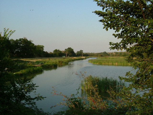
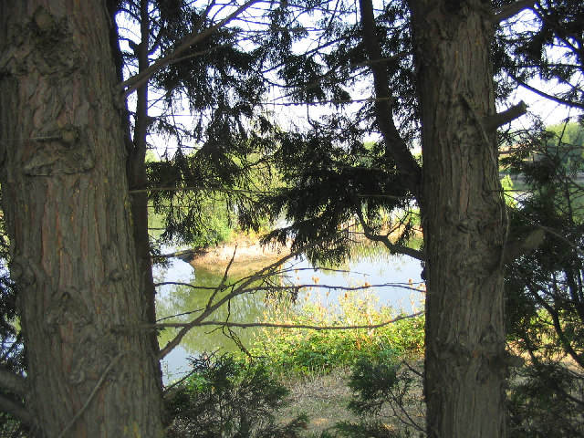
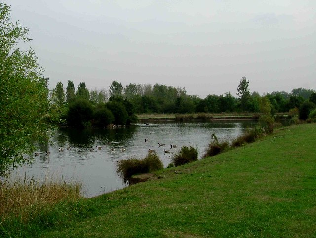
Berwick Pond, located in the county of Essex, is a picturesque freshwater marsh that is often referred to as a pond or lake due to its size and beauty. It covers an area of approximately 10 acres and is surrounded by lush vegetation and diverse wildlife.

The pond is fed by several small streams and is situated within a peaceful and tranquil setting, making it a popular destination for nature enthusiasts and those seeking a quiet escape from the hustle and bustle of everyday life. Its crystal-clear waters are home to a variety of aquatic plants, including lilies and reeds, which provide shelter and food for numerous species of fish and waterfowl.

The area surrounding Berwick Pond is abundant with wildlife, making it an ideal spot for birdwatching and wildlife photography. Visitors can often spot ducks, swans, herons, and various other bird species, as well as frogs, newts, and other amphibians that inhabit the marshy areas. The pond also supports a diverse range of insects, providing a food source for dragonflies, damselflies, and butterflies.

The pond is easily accessible, with a designated parking area nearby, and there are well-maintained footpaths that allow visitors to explore the area on foot. There is also a small picnic area where visitors can enjoy a meal while taking in the scenic views.

Overall, Berwick Pond offers a peaceful and enchanting experience for those who appreciate nature's beauty and want to immerse themselves in a serene environment. It is a haven for wildlife and a cherished natural gem in the heart of Essex.

If you have any feedback on the listing, please let us know in the comments section below.

Berwick Pond Images

Images are sourced within 2km of 51.529828/0.21724378 or Grid Reference TQ5383. Thanks to Geograph Open Source API. All images are credited.

Bluebells in clearing English bluebells just past their prime in a clearing created in Cely Woods. This site is managed by Forestry England.
Bluebells in clearing
English bluebells just past their prime in a clearing created in Cely Woods. This site is managed by Forestry England.
Old Boundary Marker on Kilmartin Way, Hornchurch Air Ministry Boundary Marker against the garden fence of No.87 Wood Lane or the northwest side of the junction with Kilmartin Way, Hornchurch. The Air Ministry existed from 1918 to 1964. RAF Hornchurch closed in 1962.

Milestone Society National ID: EX_AMHORN01em
Old Boundary Marker on Kilmartin Way, Hornchurch
Air Ministry Boundary Marker against the garden fence of No.87 Wood Lane or the northwest side of the junction with Kilmartin Way, Hornchurch. The Air Ministry existed from 1918 to 1964. RAF Hornchurch closed in 1962. Milestone Society National ID: EX_AMHORN01em
The London Loop A new footpath, part of the London Loop to the south of the Hornchurch Country Park. Picture was taken looking north.
The London Loop
A new footpath, part of the London Loop to the south of the Hornchurch Country Park. Picture was taken looking north.
The Road to Hell? A pub on South End Road serving the residents of the "Airfield Estate". The road to hell was paved with the good intent of Flying Officer Raimund Sanders-Draper an American airman posted to RAF Hornchurch. His exploits were the subject of a Musical Play produced at the Queens Theatre in Hornchurch in 2003. Sanders-Draper was killed in 1943 during a crash landing, he stayed with his stricken aircraft so he could avoid crashing into the local school,  he had sufficient height to bail out but chose to save the children. The school in Suttons Lane was renamed Sanders-Draper in his honour.
The Road to Hell?
A pub on South End Road serving the residents of the "Airfield Estate". The road to hell was paved with the good intent of Flying Officer Raimund Sanders-Draper an American airman posted to RAF Hornchurch. His exploits were the subject of a Musical Play produced at the Queens Theatre in Hornchurch in 2003. Sanders-Draper was killed in 1943 during a crash landing, he stayed with his stricken aircraft so he could avoid crashing into the local school, he had sufficient height to bail out but chose to save the children. The school in Suttons Lane was renamed Sanders-Draper in his honour.
Swords into Ploughshares One of the few parts of the old RAF Hornchurch that have survived. The concrete aircraft dispersal is surrounded with an air raid shelter in the blast protection mound, is now used as a car park for the country park. RAF Hornchurch opened in 1917 as Suttons Farm but closed at the end of WW1. A new station was opened in 1928. Spitfires from Hornchurch took part in the infamous Battle of Barking Creek in late 1939 when two Hurricanes from RAF North Weald were shot down, one of the pilots was killed <span class="nowrap"><a title="http://en.wikipedia.org/wiki/Battle_of_Barking_Creek" rel="nofollow ugc noopener" href="http://en.wikipedia.org/wiki/Battle_of_Barking_Creek">Link</a><img style="margin-left:2px;" alt="External link" title="External link - shift click to open in new window" src="https://s1.geograph.org.uk/img/external.png" width="10" height="10"/></span>. Hornchurch was a one of the most important of 11 Group's Sector stations during the Battle of Britain. It remained an RAF fighter station until spring of 1945. From 1952-62 it was the Aircrew selection centre it finally closed in 1963. Much of the airfield was built over but there are some relics in the country park. You can see some unusual airfield defences at <a href="https://www.geograph.org.uk/photo/168505">TQ5384 : Tett Turrets</a>. To go to the next field in an alphabetical tour of Essex WW2 airfields click on 
<a href="https://www.geograph.org.uk/photo/221842">TL5543 : RAF Little Walden</a>. Much information was gleaned from Graham Smith’s book “Essex Airfields In The Second World <span class="nowrap"><a title="https://books.google.co.uk/books/about/Essex_Airfields_in_the_Second_World_War.html?id=u3atAAAACAAJ&redir_esc=y" rel="nofollow ugc noopener" href="https://books.google.co.uk/books/about/Essex_Airfields_in_the_Second_World_War.html?id=u3atAAAACAAJ&redir_esc=y">Link</a><img style="margin-left:2px;" alt="External link" title="External link - shift click to open in new window" src="https://s1.geograph.org.uk/img/external.png" width="10" height="10"/></span>
Swords into Ploughshares
One of the few parts of the old RAF Hornchurch that have survived. The concrete aircraft dispersal is surrounded with an air raid shelter in the blast protection mound, is now used as a car park for the country park. RAF Hornchurch opened in 1917 as Suttons Farm but closed at the end of WW1. A new station was opened in 1928. Spitfires from Hornchurch took part in the infamous Battle of Barking Creek in late 1939 when two Hurricanes from RAF North Weald were shot down, one of the pilots was killed LinkExternal link. Hornchurch was a one of the most important of 11 Group's Sector stations during the Battle of Britain. It remained an RAF fighter station until spring of 1945. From 1952-62 it was the Aircrew selection centre it finally closed in 1963. Much of the airfield was built over but there are some relics in the country park. You can see some unusual airfield defences at TQ5384 : Tett Turrets. To go to the next field in an alphabetical tour of Essex WW2 airfields click on TL5543 : RAF Little Walden. Much information was gleaned from Graham Smith’s book “Essex Airfields In The Second World LinkExternal link
Jewish Cemetery Rainham The cemetery is located on Upminster Rd North. See inside at <a href="https://www.geograph.org.uk/photo/1417299">TQ5482 : "House of the Living"</a>
Jewish Cemetery Rainham
The cemetery is located on Upminster Rd North. See inside at TQ5482 : "House of the Living"
Berwick Pond Yet another pleasant patch of water with private fishing rights, unsurprisingly on Berwick Pond Lane! Picture was taken from the road that divides the pond looking east.
Berwick Pond
Yet another pleasant patch of water with private fishing rights, unsurprisingly on Berwick Pond Lane! Picture was taken from the road that divides the pond looking east.
For The Brylcreem Boys This memorial is in the grounds of a primary school named after the chief designer of the Spitfire, R.J Mitchell. It reads "Site of RAF Hornchurch sector airfield for No 11 Group. To all aircrew & ground personnel who served here 1928-1962". Some of the famous names who served here include Douglas Bader, Bob Stanford Tuck and A.G "Sailor" Malan.
For The Brylcreem Boys
This memorial is in the grounds of a primary school named after the chief designer of the Spitfire, R.J Mitchell. It reads "Site of RAF Hornchurch sector airfield for No 11 Group. To all aircrew & ground personnel who served here 1928-1962". Some of the famous names who served here include Douglas Bader, Bob Stanford Tuck and A.G "Sailor" Malan.
Malan Square South Hornchurch Low rise social housing built around a green, a large portion of which is now a car park.
Malan Square South Hornchurch
Low rise social housing built around a green, a large portion of which is now a car park.
St George's Hospital St George's is now part of Havering Hospitals NHS Trust which was established in 1993. The North East London Strategic Health Authority is considering closing the hospital. The property developers must be drooling at the prospect of a brown-field site surrounded on two sides by countryside!
St George's Hospital
St George's is now part of Havering Hospitals NHS Trust which was established in 1993. The North East London Strategic Health Authority is considering closing the hospital. The property developers must be drooling at the prospect of a brown-field site surrounded on two sides by countryside!
Recycling Centre, Gerpins Lane, Upminster What we used to call the 'council tip' is now a 'Re-use & Recycling Centre' run by private contractors for Havering Council
Recycling Centre, Gerpins Lane, Upminster
What we used to call the 'council tip' is now a 'Re-use & Recycling Centre' run by private contractors for Havering Council
Fishing Lakes, Warwick Lane, Rainham This is a private fishing lake owned by Thurrock Angling Club. Like most lakes in this area, this was a gravel pit.
Fishing Lakes, Warwick Lane, Rainham
This is a private fishing lake owned by Thurrock Angling Club. Like most lakes in this area, this was a gravel pit.
Cely Wood, Thames Chase, Upminster Part of Thames Chase Urban Forest. This newly constructed woodland lies on the south side of Warwick Lane.
Cely Wood, Thames Chase, Upminster
Part of Thames Chase Urban Forest. This newly constructed woodland lies on the south side of Warwick Lane.
"Field Blockade", Berwick Pond Road, Hornchurch A familiar sight around this area, is old heavy farm equipment blockading access to fields from the 'travelling' community.
"Field Blockade", Berwick Pond Road, Hornchurch
A familiar sight around this area, is old heavy farm equipment blockading access to fields from the 'travelling' community.
"Destruction & Renovation", Little Gerpins Lane, Upminster The familiar sight on the urban fringe of a 'burnt' out wrecked car. Ironically the car is dumped in front of a sign for the 'Little Gerpins Lane Renovation Project' - which I presume refers to the land and not the car!
"Destruction & Renovation", Little Gerpins Lane, Upminster
The familiar sight on the urban fringe of a 'burnt' out wrecked car. Ironically the car is dumped in front of a sign for the 'Little Gerpins Lane Renovation Project' - which I presume refers to the land and not the car!
Rainham Tyres This is a small retail tyre and battery outlet is sandwiched between 1930’s houses in Upminster Road Rainham.
Rainham Tyres
This is a small retail tyre and battery outlet is sandwiched between 1930’s houses in Upminster Road Rainham.
Albyns Farm Pond This pond is to the east of Albyns Farm on the Hornchurch Country Park. The London Loop long distance path runs past the far end of the pond
Albyns Farm Pond
This pond is to the east of Albyns Farm on the Hornchurch Country Park. The London Loop long distance path runs past the far end of the pond
Ripe for Development (Rainham) Surely this apparently derelict builders merchants in Upminster Rd Rainham cannot remain in this state for long? The pressure to build on brown field sites in the Thames corridor is immense. I expect there are queues of property developers knocking at the freeholder’s door! Also in this picture you can see the “shrine” to an 11-year-old girl killed on the road near this spot.
Ripe for Development (Rainham)
Surely this apparently derelict builders merchants in Upminster Rd Rainham cannot remain in this state for long? The pressure to build on brown field sites in the Thames corridor is immense. I expect there are queues of property developers knocking at the freeholder’s door! Also in this picture you can see the “shrine” to an 11-year-old girl killed on the road near this spot.
Show me another place!

Berwick Pond is located at Grid Ref: TQ5383 (Lat: 51.529828, Lng: 0.21724378)

Unitary Authority: Havering

Police Authority: Metropolitan

What 3 Words

///fork.award.either. Near Elm Park, London

Related Wikis

Nearby Amenities

Located within 500m of 51.529828,0.21724378
Turning Circle
Lat/Long: 51.5283117/0.2177502
Turning Circle
Lat/Long: 51.5274429/0.2123363
Bus Stop
Abbey Wood Lane
Naptan AtcoCode: 490003037E
Naptan Bearing: E
Naptan CommonName: Abbey Wood Lane (Rainham)
Naptan Street: ABBEY WOOD LANE
Naptan Verified: no
Public Transport: platform
Lat/Long: 51.5293426/0.2130111
Bus Stop
Thorn Lane
Bus: yes
Naptan AtcoCode: 490003940S
Naptan Bearing: N
Naptan CommonName: Berwick Road
Naptan Street: BERWICK ROAD
Naptan Verified: no
Public Transport: platform
Ref: 73123
Shelter: yes
Source Ref: naptan
Lat/Long: 51.526487/0.2144524
Bus Stop
Lake Avenue
Naptan AtcoCode: 490008907N
Naptan Bearing: N
Naptan CommonName: Lake Avenue
Naptan Street: LAKE AVENUE
Naptan Verified: no
Public Transport: platform
Lat/Long: 51.5257543/0.2173448
Bus Stop
Lake Avenue
Naptan AtcoCode: 490008907S
Naptan Bearing: N
Naptan CommonName: Lake Avenue
Naptan Street: LAKE AVENUE
Naptan Verified: no
Public Transport: platform
Lat/Long: 51.5254791/0.2175879
Turning Circle
Lat/Long: 51.5279228/0.2158653
Bench
Backrest: no
Lat/Long: 51.5313919/0.2151297
Bench
Backrest: no
Lat/Long: 51.5308678/0.2145895
Bench
Backrest: yes
Lat/Long: 51.5299297/0.2139955
Post Box
Lat/Long: 51.5257728/0.214899
Waste Basket
Lat/Long: 51.5258044/0.2148904
Addr City: Rainham
Addr Housenumber: 23A-23B
Addr Street: Abbey Wood Lane
Entrance: yes
Lat/Long: 51.529395/0.2119751
Addr City: Rainham
Addr Housenumber: 23C-23D
Addr Street: Abbey Wood Lane
Entrance: yes
Lat/Long: 51.5294111/0.2120515
Addr City: Rainham
Addr Housenumber: 23E-23F
Addr Street: Abbey Wood Lane
Entrance: yes
Lat/Long: 51.529428/0.2121281
Grit Bin
Lat/Long: 51.528523/0.2103214
Fire Hydrant
Emergency: fire_hydrant
Fire Hydrant Type: underground
Water Source: main
Lat/Long: 51.5269369/0.2143943
Fire Hydrant
Emergency: fire_hydrant
Fire Hydrant Type: underground
Water Source: main
Lat/Long: 51.5285071/0.2129238
Fire Hydrant
Emergency: fire_hydrant
Fire Hydrant Type: underground
Water Source: main
Lat/Long: 51.5262076/0.217159
Fire Hydrant
Emergency: fire_hydrant
Fire Hydrant Type: underground
Water Source: main
Lat/Long: 51.5258626/0.2150374
Fire Hydrant
Emergency: fire_hydrant
Fire Hydrant Type: underground
Water Source: main
Lat/Long: 51.5261743/0.2190761
Fire Hydrant
Emergency: fire_hydrant
Fire Hydrant Type: underground
Water Source: main
Lat/Long: 51.5277708/0.2185987
Access: private
Addr Flats: 66A
Entrance: yes
Lat/Long: 51.5257482/0.2177346
Access: private
Addr Flats: 66
Entrance: yes
Lat/Long: 51.5257412/0.2176746
Access: private
Addr Flats: 64
Entrance: yes
Lat/Long: 51.525632/0.2177068
Access: private
Addr Flats: 64A
Entrance: yes
Lat/Long: 51.5256391/0.2177667
Bicycle Parking
Bicycle Parking: stands
Capacity: 2
Ref GB Tflcid: RWG122659
Lat/Long: 51.525827/0.2149022
The data included in this document is from www.openstreetmap.org. The data is made available under ODbL.

Have you been to Berwick Pond?

Leave your review of Berwick Pond below (or comments, questions and feedback).