Spring Wood

Wood, Forest in Yorkshire Ryedale

England

Spring Wood

Hill End House Hill End House to the west of Hawnby Hill.
Hill End House Credit: T Eyre

Spring Wood is a picturesque woodland located in the county of Yorkshire, England. Spread across a vast area, it is renowned for its natural beauty and tranquil atmosphere. The wood is situated near the charming village of Spring, which adds to its allure.

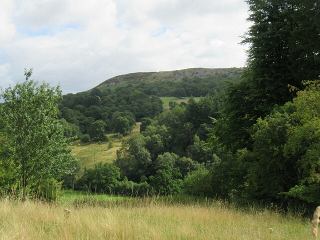
Characterized by its dense foliage and varied tree species, Spring Wood offers a captivating display of colors throughout the year. In springtime, the woodland bursts into life with vibrant blossoms and blossoming flowers, creating a breathtaking sight. The wood is predominantly composed of native tree species such as oak, beech, birch, and hazel, which further adds to its ecological importance.

Numerous walking trails crisscross the wood, allowing visitors to explore its enchanting corners at their own pace. These well-maintained paths wind through the woodland, offering glimpses of wildlife and providing ample opportunities for birdwatching. The wood is known to be home to a diverse range of animal species, including deer, foxes, badgers, and a variety of bird species.

Spring Wood also boasts a rich history, with evidence of human habitation dating back centuries. Remnants of ancient settlements, including burial mounds and stone circles, can be found within its boundaries. These historical features add an element of intrigue to the wood, inviting visitors to delve into its past.

Overall, Spring Wood in Yorkshire is a haven of natural beauty, offering a serene escape from the hustle and bustle of everyday life. Its stunning landscapes, abundant wildlife, and historical significance make it a must-visit destination for nature enthusiasts and history buffs alike.

If you have any feedback on the listing, please let us know in the comments section below.

Spring Wood Images

Images are sourced within 2km of 54.299645/-1.1972817 or Grid Reference SE5289. Thanks to Geograph Open Source API. All images are credited.
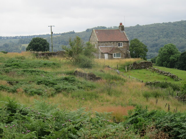
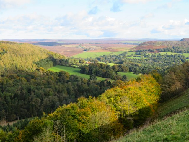
Hill End House Hill End House to the west of Hawnby Hill.
Hill End House
Hill End House to the west of Hawnby Hill.
Hilltop pasture above Stoney Gill Hole Near level pasture on the hilltop, but the fence to the left is just above a very steep drop into the narrow little valley that is Stoney Gill Hole. The three ridges of Hawnby Hill, Easterside and Roppa Edge in the distance.
Hilltop pasture above Stoney Gill Hole
Near level pasture on the hilltop, but the fence to the left is just above a very steep drop into the narrow little valley that is Stoney Gill Hole. The three ridges of Hawnby Hill, Easterside and Roppa Edge in the distance.
View over Thorodale Beyond the wall the ground plunges steeply down into the well wooded valley of Thorodale where the hillsides echoed with the sound of gunfire from pheasant shooting [no Geograph contributors were harmed]. Mount Pleasant Farm is visible near the centre of the photo, whilst the northern prow of Hawnby Hill is prominent to the right.
View over Thorodale
Beyond the wall the ground plunges steeply down into the well wooded valley of Thorodale where the hillsides echoed with the sound of gunfire from pheasant shooting [no Geograph contributors were harmed]. Mount Pleasant Farm is visible near the centre of the photo, whilst the northern prow of Hawnby Hill is prominent to the right.
Bridleway Through Thorodale The majority of the land in Thorodale is part of Hawnby Estate and is mostly managed woodland. Signage indicates that areas not on the public rights of way may be visited on application to the estate office provided there are no ongoing forestry works.
Bridleway Through Thorodale
The majority of the land in Thorodale is part of Hawnby Estate and is mostly managed woodland. Signage indicates that areas not on the public rights of way may be visited on application to the estate office provided there are no ongoing forestry works.
View Across Stubble Field To Coomb Hill
Arden Hall Seat of the Earl of Mexborough, purchased in 1897 from the Tancred family who had owned the property for the previous 300 years. Grade II listed.
Arden Hall
Seat of the Earl of Mexborough, purchased in 1897 from the Tancred family who had owned the property for the previous 300 years. Grade II listed.
Track Above Thorodale Providing access from Arden Hall across the moor to Hambleton Street ancient track.
Track Above Thorodale
Providing access from Arden Hall across the moor to Hambleton Street ancient track.
Near New Hall Looking east from the road towards Hawnby Hill.
Near New Hall
Looking east from the road towards Hawnby Hill.
Above the Hawnby road The line of trees below the camera position mark the line of the Kepwick to Hawnby road, which for some 2.5mls across the moor is rough surfaced and unsuitable for cars. The view is towards the fields around Arden Hall, the valley of the River Rye and Hawnby Hill beyond to the right.
Above the Hawnby road
The line of trees below the camera position mark the line of the Kepwick to Hawnby road, which for some 2.5mls across the moor is rough surfaced and unsuitable for cars. The view is towards the fields around Arden Hall, the valley of the River Rye and Hawnby Hill beyond to the right.
Thorodale Lake The small lake sits in the bottom of a deep wooded valley, but it is an artificial lake of relatively recent construction. It isn't shown on the first edition OS map of the 1850's, and first appears on the 1910 edition where it is shown as 'Fish Pond' and presumably a part of the Arden estate.
Thorodale Lake
The small lake sits in the bottom of a deep wooded valley, but it is an artificial lake of relatively recent construction. It isn't shown on the first edition OS map of the 1850's, and first appears on the 1910 edition where it is shown as 'Fish Pond' and presumably a part of the Arden estate.
Tracks  in  North  Moor  Wood  Thorodale
Tracks in North Moor Wood Thorodale
Footpath  to  Harker  Gates From Mount Pleasant Farm
Footpath to Harker Gates
From Mount Pleasant Farm
View towards Hawnby Hill Crag Taken from Peak Scar. Hawnby Hill Crag is a limestone ridge overlooking upper Ryedale.
View towards Hawnby Hill Crag
Taken from Peak Scar. Hawnby Hill Crag is a limestone ridge overlooking upper Ryedale.
Harker Gates And Blueberry Wood A majestic Ash tree grows in the pasture below Harker Gates cottage.
Harker Gates And Blueberry Wood
A majestic Ash tree grows in the pasture below Harker Gates cottage.
The road to Kepwick The road from Hawnby to Kepwick on the approach to New Hall. Motorists would be well advised not to attempt to drive this way to Kepwick as the tarmac finishes at Arden Hall, after which there is about 3 miles of rough track before tarmac reappears at the top of Kepwick Bank. The photographer does admit to driving a VW Beetle across here several decades ago.
The road to Kepwick
The road from Hawnby to Kepwick on the approach to New Hall. Motorists would be well advised not to attempt to drive this way to Kepwick as the tarmac finishes at Arden Hall, after which there is about 3 miles of rough track before tarmac reappears at the top of Kepwick Bank. The photographer does admit to driving a VW Beetle across here several decades ago.
Path to St Agnes House Track and public footpath following the woodland edge between New Hall and St Agnes House.
Path to St Agnes House
Track and public footpath following the woodland edge between New Hall and St Agnes House.
St Agnes House Hillside farm in upper Ryedale.
St Agnes House
Hillside farm in upper Ryedale.
St Agnes House From this direction the farmhouse is largely hidden behind the barns. The view is across upper Ryedale towards Hawnby Hill.
St Agnes House
From this direction the farmhouse is largely hidden behind the barns. The view is across upper Ryedale towards Hawnby Hill.
Show me another place!

Spring Wood is located at Grid Ref: SE5289 (Lat: 54.299645, Lng: -1.1972817)

Division: North Riding

Administrative County: North Yorkshire

District: Ryedale

Police Authority: North Yorkshire

What 3 Words

///transcribes.incurring.focal. Near Bilsdale, North Yorkshire

Related Wikis

Hawnby

Hawnby is a small crossroads village and civil parish in Ryedale in the North York Moors National Park, North Yorkshire, England. The village is about...

Laskill

Laskill is a small hamlet in Bilsdale, 5 miles (8 km) north-west of Helmsley, North Yorkshire, England, on the road from Helmsley to Stokesley and is located...

Holy Trinity Church, Boltby

Holy Trinity Church, Boltby is a parish church in the Church of England: 81  in Boltby. == History == The first chapel was founded in 1409 and was rebuilt...

Boltby

Boltby is a village and civil parish in the Hambleton District of North Yorkshire, England. It is on the edge of the North York Moors National Park at...

Kepwick

Kepwick is a village and civil parish in the Hambleton district of North Yorkshire, England, on the North York Moors and near the A19. The population according...

Cold Kirby

Cold Kirby is a village and civil parish in the Ryedale district of North Yorkshire, England. The population at the 2011 census (including Angram Grange...

Cowesby

Cowesby is a village and civil parish in the Hambleton District of North Yorkshire, England. Part of the village including The Cowesby Hall Estate is within...

Kirby Knowle

Kirby Knowle is a village and civil parish in Hambleton District of North Yorkshire, England, on the border of the North Yorkshire Moors and near Upsall...

Nearby Amenities

Located within 500m of 54.299645,-1.1972817
High Buildings
Place: isolated_dwelling
Lat/Long: 54.2971892/-1.1936458
Natural: spring
Lat/Long: 54.2992783/-1.1936196
Natural: spring
Lat/Long: 54.2993253/-1.1939603
Natural: spring
Lat/Long: 54.2997103/-1.1970314
Natural: spring
Lat/Long: 54.299294/-1.1938128
Natural: spring
Lat/Long: 54.2996994/-1.1969027
The data included in this document is from www.openstreetmap.org. The data is made available under ODbL.

Have you been to Spring Wood?

Leave your review of Spring Wood below (or comments, questions and feedback).