Pit Plantation

Wood, Forest in Yorkshire

England

Pit Plantation

Billy Woods rock formation, Kippax
Billy Woods rock formation, Kippax Credit: derek dye

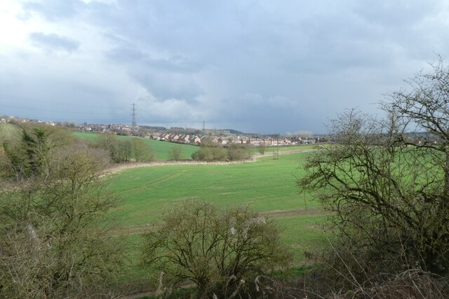
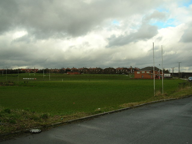
Pit Plantation is a captivating woodland located in Yorkshire, England. Nestled amidst the picturesque countryside, this forested area spans across a vast expanse, covering roughly 500 acres. The plantation primarily consists of a diverse range of trees, including oak, beech, birch, and pine, creating a rich and varied ecosystem.

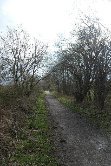
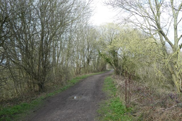
Visitors to Pit Plantation are greeted by a network of well-maintained footpaths, allowing them to explore the beauty of the woodland at their own pace. The paths wind through the forest, leading visitors through enchanting glades, towering groves, and serene clearings. The dense canopy of trees provides shade and shelter, while also creating a sense of tranquility and seclusion.

The plantation is not only a haven for nature enthusiasts but also serves as a habitat for a variety of wildlife. Numerous bird species, such as thrushes, woodpeckers, and owls, can be spotted amongst the branches. Deer, foxes, and rabbits also roam freely within the woodland, adding to the sense of natural beauty and wilderness.

Pit Plantation offers a range of recreational activities for visitors to enjoy. Hiking and walking are popular pursuits, with the well-marked trails providing ample opportunities to explore the woodland. Additionally, the plantation is a favored spot for nature photography, bird watching, and picnicking.

With its breathtaking scenery, diverse flora and fauna, and recreational opportunities, Pit Plantation is a treasured destination for both locals and tourists alike. Whether seeking solace in nature or embarking on an outdoor adventure, this Yorkshire woodland provides an idyllic retreat for all who visit.

If you have any feedback on the listing, please let us know in the comments section below.

Pit Plantation Images

Images are sourced within 2km of 53.752148/-1.3719359 or Grid Reference SE4128. Thanks to Geograph Open Source API. All images are credited.

Billy Woods rock formation, Kippax
Above Townclose Wood Looking towards Kippax from The Lines Way.
Above Townclose Wood
Looking towards Kippax from The Lines Way.
Cycle path from Garforth The Lines Way is a cycle path from Garforth to Allerton Bywater along the former railway line. It is designated as part of National Cycle Network route 697.
Cycle path from Garforth
The Lines Way is a cycle path from Garforth to Allerton Bywater along the former railway line. It is designated as part of National Cycle Network route 697.
Cycle path to Garforth The Lines Way is a cycle path from Garforth to Allerton Bywater along the former railway line. It is designated as part of National Cycle Network route 697.
Cycle path to Garforth
The Lines Way is a cycle path from Garforth to Allerton Bywater along the former railway line. It is designated as part of National Cycle Network route 697.
Kippax Welfare Club rugby ground
Mural, Main Street, Kippax On the side of Central Fisheries, and near Kevins Hair Design (for men and women), on the town's main street.
Mural, Main Street, Kippax
On the side of Central Fisheries, and near Kevins Hair Design (for men and women), on the town's main street.
Kippax, St Mary's Church
St Mary's Church - Church Lane, Kippax
St Mary's Graveyard - Church Lane, Kippax
St Mary's Church Hall - off Church Street, Kippax
Ash Tree Primary School - Leeds Road, Kippax
Kippax Ex-Service & Social Club - Leeds Road, Kippax
The Royal Oak - Cross Hills, Kippax
Kippax Youth & Adult Centre - Cross Hills, Kippax
The White Swan - Cross Hills, Kippax
Barclays Bank Ltd - High Street, Kippax
Kippax High Street
Kippax High Street
Kippax Post Office - High Street
Show me another place!

Pit Plantation is located at Grid Ref: SE4128 (Lat: 53.752148, Lng: -1.3719359)

Division: West Riding

Unitary Authority: Leeds

Police Authority: West Yorkshire

What 3 Words

///inspects.inflating.evaporate. Near Kippax, West Yorkshire

Related Wikis

Bowers railway station

Bowers railway station was a station opened in 1934 by the London and North Eastern Railway (LNER) on the Castleford–Garforth line, in the West Riding...

Brigshaw High School

Brigshaw High School is a coeducational secondary school and sixth form located in the village of Allerton Bywater, West Yorkshire, England. == History... ==

Allerton Bywater colliery explosion

The Allerton Bywater colliery explosion was a mining accident at the Allerton Bywater Colliery in Allerton Bywater, England, which occurred on Monday 10...

Great Preston

Great Preston is a small rural village in the City of Leeds metropolitan borough, West Yorkshire, England. It has incorporated the once neighbouring hamlet...

Kippax railway station

Kippax railway station was a railway station on the Castleford–Garforth line in West Yorkshire, England. The station opened in 1878 and closed to passengers...

Ledston railway station

Ledston railway station was a railway station on the now disused Castleford–Garforth line in West Yorkshire, England. The station opened in 1878 and was...

Allerton Bywater

Allerton Bywater is a semi-rural village and civil parish in the south-east of the City of Leeds metropolitan borough in West Yorkshire, England. The population...

Lower Mickletown

Lower Mickletown is a hamlet in the City of Leeds, in the English county of West Yorkshire. It was named Low Mickletown in the early 20th century and has...

Nearby Amenities

Located within 500m of 53.752148,-1.3719359
Traffic Calming: table
Lat/Long: 53.7485815/-1.3756318
Turning Circle
Lat/Long: 53.7495778/-1.3759763
Turning Circle
Lat/Long: 53.7502508/-1.3749677
Traffic Calming: table
Lat/Long: 53.748529/-1.3755445
Bus Stop
Leeds Road Westfield Grove
Bus: yes
Local Ref: 45010152
Naptan AtcoCode: 450010152
Naptan Bearing: E
Naptan CommonName: Leeds Road Westfield Grove
Naptan Crossing: Westfield Grove
Naptan Indicator: Stop 45010152
Naptan PlusbusZoneRef: LEEDS
Naptan ShortCommonName: Westfield Grove
Naptan Street: Leeds Road
Naptan Verified: no
Network: Metro West Yorkshire
Network Wikidata: Q7987043
Public Transport: platform
Source: naptan_import
Lat/Long: 53.749763/-1.3781783
Bus Stop
Leeds Road Westfield Grove
Bus: yes
Local Ref: 45010153
Naptan AtcoCode: 450010153
Naptan Bearing: W
Naptan CommonName: Leeds Road Westfield Grove
Naptan Crossing: Westfield Grove
Naptan Indicator: Stop 45010153
Naptan PlusbusZoneRef: LEEDS
Naptan ShortCommonName: Westfield Grove
Naptan Street: Leeds Road
Naptan Verified: no
Network: Metro West Yorkshire
Network Wikidata: Q7987043
Public Transport: platform
Source: naptan_import
Lat/Long: 53.7496641/-1.3781646
Bus Stop
Leeds Road Blands Avenue
Bus: yes
Local Ref: 45010155
Naptan AtcoCode: 450010155
Naptan Bearing: SE
Naptan CommonName: Leeds Road Blands Avenue
Naptan Crossing: Blands Avenue
Naptan Indicator: Stop 45010155
Naptan PlusbusZoneRef: LEEDS
Naptan ShortCommonName: Blands Avenue
Naptan Street: Leeds Road
Naptan Verified: no
Network: Metro West Yorkshire
Network Wikidata: Q7987043
Public Transport: platform
Source: naptan_import
Lat/Long: 53.7483607/-1.3751503
Bus Stop
Leeds Road Blands Avenue
Bus: yes
Local Ref: 45010156
Naptan AtcoCode: 450010156
Naptan Bearing: NW
Naptan CommonName: Leeds Road Blands Avenue
Naptan Crossing: Blands Avenue
Naptan Indicator: Stop 45010156
Naptan PlusbusZoneRef: LEEDS
Naptan ShortCommonName: Blands Avenue
Naptan Street: Leeds Road
Naptan Verified: no
Network: Metro West Yorkshire
Network Wikidata: Q7987043
Public Transport: platform
Shelter: yes
Source: naptan_import
Lat/Long: 53.748319/-1.3753221
Barrier: cycle_barrier
Lat/Long: 53.750752/-1.3755226
Barrier: cycle_barrier
Bicycle: yes
Foot: yes
Motor Vehicle: no
Lat/Long: 53.7508611/-1.3753495
Turning Circle
Lat/Long: 53.7477097/-1.3712061
Turning Circle
Lat/Long: 53.7496685/-1.3735343
Turning Circle
Lat/Long: 53.7496558/-1.3751195
Power: pole
Lat/Long: 53.749875/-1.3661156
Power: pole
Lat/Long: 53.7498777/-1.3670158
Power: pole
Lat/Long: 53.7510491/-1.3651547
Power: pole
Lat/Long: 53.7512137/-1.3657612
Power: pole
Lat/Long: 53.7512756/-1.364914
Power: pole
Lat/Long: 53.7518085/-1.366913
Power: pole
Lat/Long: 53.7522416/-1.3696097
Power: pole
Lat/Long: 53.7530141/-1.371301
Power: pole
Lat/Long: 53.754245/-1.3722835
Power: pole
Lat/Long: 53.7554522/-1.3732197
Turning Circle
Lat/Long: 53.7505989/-1.3775415
Kindergarten
The Grange
Addr City: Castleford
Addr Postcode: WF10 2HJ
Addr Street: Doctors Lane
Addr Suburb: Allerton Bywater
Fhrs Id: 321521
Lat/Long: 53.7495403/-1.3756755
Waste Basket
Collection Times: Sa
Ref UK Leedscc Bin: 921
Lat/Long: 53.750682/-1.375477
Waste Basket
Collection Times: Sa
Ref UK Leedscc Bin: 922
Lat/Long: 53.750419/-1.375486
Waste Basket
Collection Times: Sa
Ref UK Leedscc Bin: 3561
Lat/Long: 53.749882/-1.378098
Waste Basket
Collection Times: Sa
Ref UK Leedscc Bin: 1775
Lat/Long: 53.749677/-1.378197
Waste Basket
Collection Times: Sa
Ref UK Leedscc Bin: 1776
Lat/Long: 53.748635/-1.375491
Noexit: yes
Lat/Long: 53.7506335/-1.376269
Noexit: yes
Lat/Long: 53.7504804/-1.3757697
Noexit: yes
Lat/Long: 53.7489689/-1.3758002
Noexit: yes
Lat/Long: 53.7491319/-1.3760376
Noexit: yes
Lat/Long: 53.7492838/-1.3737047
Turning Circle
Lat/Long: 53.7485042/-1.3742738
Power: pole
Lat/Long: 53.7498792/-1.3679753
Power: pole
Lat/Long: 53.7498833/-1.36906
Power: pole
Lat/Long: 53.7498955/-1.3702777
Power: pole
Lat/Long: 53.749905/-1.3713602
Power: pole
Lat/Long: 53.7499063/-1.3725114
Power: pole
Lat/Long: 53.7502345/-1.3733851
Power: pole
Lat/Long: 53.7505627/-1.3742405
Power: pole
Lat/Long: 53.7508773/-1.3751212
Power: pole
Lat/Long: 53.7514142/-1.3759353
Power: pole
Lat/Long: 53.7519499/-1.3767288
Power: pole
Lat/Long: 53.7524895/-1.3775452
Power: pole
Lat/Long: 53.7530212/-1.3783685
Material: wood
Power: pole
Lat/Long: 53.7529166/-1.3792772
Bowers
Historic Railway: station
Railway: site
Wikidata: Q63919267
Wikipedia: en:Bowers railway station
Lat/Long: 53.7522872/-1.378123
Leeds Road Westfield Grove
Bus: yes
Local Ref: 45010152
Public Transport: stop_position
Lat/Long: 53.7496805/-1.3780576
Leeds Road Blands Avenue
Bus: yes
Local Ref: 45010155
Public Transport: stop_position
Lat/Long: 53.7482674/-1.3750669
Leeds Road Blands Avenue
Bus: yes
Local Ref: 45010156
Network: Metro West Yorkshire
Public Transport: stop_position
Lat/Long: 53.7484036/-1.3753155
Traffic Calming: bump
Lat/Long: 53.7486602/-1.3757674
Traffic Calming: bump
Lat/Long: 53.7484765/-1.3754486
The data included in this document is from www.openstreetmap.org. The data is made available under ODbL.

Have you been to Pit Plantation?

Leave your review of Pit Plantation below (or comments, questions and feedback).