Fir Wood

Wood, Forest in Somerset

England

Fir Wood

Shallow fog & hot air balloons over the Avon Valley as seen from Kelston Park
Shallow fog & hot air balloons over the Avon Valley as seen from Kelston Park Credit: Colin Park

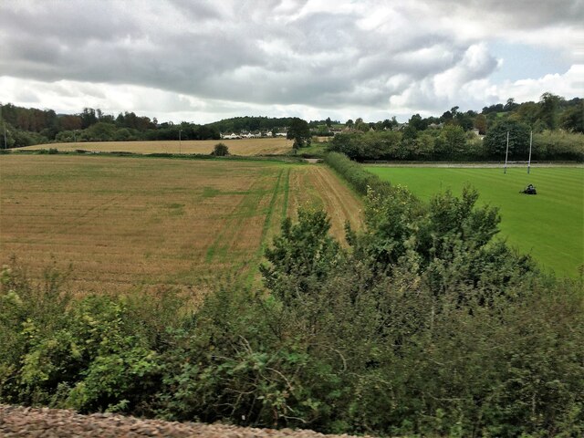
Fir Wood, located in Somerset, England, is a picturesque forest renowned for its stunning natural beauty and abundant fir trees. Spanning over a vast area, this woodland is a haven for nature enthusiasts and a popular destination for those seeking tranquility and serenity.

The forest is primarily composed of fir trees, which dominate the landscape with their tall, straight trunks and dense, evergreen foliage. These trees create a dense canopy that filters sunlight, creating a cool and shaded environment beneath. The forest floor is covered with a thick layer of moss, adding to the enchanting atmosphere of the woodland.

Fir Wood is home to a diverse range of wildlife, including numerous bird species, such as woodpeckers and owls. The forest also provides a habitat for small mammals like squirrels and rabbits, as well as various species of insects and butterflies. The tranquility of the woodland is often interrupted by the melodic chirping of birds or the rustling of leaves as animals scurry about their daily routines.

Visitors to Fir Wood can enjoy a range of activities, from leisurely walks along well-maintained trails to birdwatching or simply finding a peaceful spot to sit and immerse themselves in the serene atmosphere. The forest is also a popular spot for photography enthusiasts, who are captivated by the beauty of the towering fir trees and the interplay of light and shadows.

Overall, Fir Wood in Somerset presents a natural sanctuary where visitors can escape the hustle and bustle of everyday life, immerse themselves in the beauty of nature, and reconnect with the serenity of the great outdoors.

If you have any feedback on the listing, please let us know in the comments section below.

Fir Wood Images

Images are sourced within 2km of 51.393957/-2.4202131 or Grid Reference ST7066. Thanks to Geograph Open Source API. All images are credited.

Shallow fog & hot air balloons over the Avon Valley as seen from Kelston Park
Saltford - The River Avon east of Saltford Marina
Old Boundary Markers beside the A4 on Newton Bridge On Newton Bridge over Corston Brook, on the southwest side of the A4 Bristol Road.

On the left, on the boundary of Newton St Loe and Corston parishes, is Turnpike Parish Boundary Marker SO_BABR03pb. On its left face is NEWT.N / P.H and on its right face is CORST.N / P.H with BRISTOL TURNPIKE TRUST vertically between them and 1823 horizontally above. See also <a title="https://www.geograph.org.uk/photo/6038123" href="https://www.geograph.org.uk/photo/6038123">Link</a>.

On the right, entirely in Corston parish, is bridge marker SO_CORST01br.
Old Boundary Markers beside the A4 on Newton Bridge
On Newton Bridge over Corston Brook, on the southwest side of the A4 Bristol Road. On the left, on the boundary of Newton St Loe and Corston parishes, is Turnpike Parish Boundary Marker SO_BABR03pb. On its left face is NEWT.N / P.H and on its right face is CORST.N / P.H with BRISTOL TURNPIKE TRUST vertically between them and 1823 horizontally above. See also Link. On the right, entirely in Corston parish, is bridge marker SO_CORST01br.
From a Swindon-Bristol train, fields and playing field near Corston
From a Swindon-Bristol train, alongside the River Avon
Old Boundary Marker beside the A39 Wells Road, Corston Turnpike Parish Boundary Marker on the grass verge on the south side of the A39 Wells Road east of Corston village. Corston parish. Grade II Listed details <span class="nowrap"><a title="https://historicengland.org.uk/listing/the-list/list-entry/1320799" rel="nofollow ugc noopener" href="https://historicengland.org.uk/listing/the-list/list-entry/1320799">Link</a><img style="margin-left:2px;" alt="External link" title="External link - shift click to open in new window" src="https://s1.geograph.org.uk/img/external.png" width="10" height="10"/></span>. For an older photo, see <a title="https://www.geograph.org.uk/photo/6048086" href="https://www.geograph.org.uk/photo/6048086">Link</a>. See also <a title="https://www.geograph.org.uk/photo/5883994" href="https://www.geograph.org.uk/photo/5883994">Link</a> and <a title="https://www.geograph.org.uk/photo/1719253" href="https://www.geograph.org.uk/photo/1719253">Link</a>.

Milestone Society National ID: SO_BAMK03pb
Old Boundary Marker beside the A39 Wells Road, Corston
Turnpike Parish Boundary Marker on the grass verge on the south side of the A39 Wells Road east of Corston village. Corston parish. Grade II Listed details LinkExternal link. For an older photo, see Link. See also Link and Link. Milestone Society National ID: SO_BAMK03pb
The River Avon by Saltford
The River Avon by Corston
Avon Boathouse A small boathouse along the River Avon outside of Bath close to Saltford Marina
Avon Boathouse
A small boathouse along the River Avon outside of Bath close to Saltford Marina
Across the Avon near Saltford, 1966 Looking across the river (flowing to the left) from the railway line between Bristol and Bath, with the former Mangotsfield and Bath railway line, which has now become the Bristol and Bath Railway Path. Above it rises Tennant's Wood. See also <a href="https://www.geograph.org.uk/photo/2447349">ST6966 : The River Avon by Saltford</a>..
Across the Avon near Saltford, 1966
Looking across the river (flowing to the left) from the railway line between Bristol and Bath, with the former Mangotsfield and Bath railway line, which has now become the Bristol and Bath Railway Path. Above it rises Tennant's Wood. See also ST6966 : The River Avon by Saltford..
Balloon near Bath Looking north from the path near Seven Acre Wood towards Saltford.
Balloon near Bath
Looking north from the path near Seven Acre Wood towards Saltford.
Train near Saltford Train travelling the main line between Bath and Bristol just before Saltford
Train near Saltford
Train travelling the main line between Bath and Bristol just before Saltford
High Speed Train near Corston Train passing the Rugby ground at Corston.
High Speed Train near Corston
Train passing the Rugby ground at Corston.
Plenty of fresh air Keeping the windows open has some advantages.
Plenty of fresh air
Keeping the windows open has some advantages.
Cockey, men of iron Lewis Cockey came to Frome in about 1685 from a family of clockmakers. He branched out into bell casting (many still survive in churches locally), but his later descendant Edward Cockey (1781-1860) also took to making ironwork and fittings for gas supplies and the like. The firm eventually closed in 1960 but not after creating a wealth of iron hardware, including farm equipment.
Cockey, men of iron
Lewis Cockey came to Frome in about 1685 from a family of clockmakers. He branched out into bell casting (many still survive in churches locally), but his later descendant Edward Cockey (1781-1860) also took to making ironwork and fittings for gas supplies and the like. The firm eventually closed in 1960 but not after creating a wealth of iron hardware, including farm equipment.
Young cattle A couple of recent additions to the Manor Farm herd.
Young cattle
A couple of recent additions to the Manor Farm herd.
Tagged already These little creatures have been ear tagged and documented before they really knew it.
Tagged already
These little creatures have been ear tagged and documented before they really knew it.
The milking shed It's not the nicest of odours or sights at times but the machinery is pretty efficient at milking the cattle.
The milking shed
It's not the nicest of odours or sights at times but the machinery is pretty efficient at milking the cattle.
Show me another place!

Fir Wood is located at Grid Ref: ST7066 (Lat: 51.393957, Lng: -2.4202131)

Unitary Authority: Bath and North East Somerset

Police Authority: Avon and Somerset

What 3 Words

///equivocal.notice.quietest. Near Corston, Somerset

Related Wikis

Kelston toll road

The Kelston toll road was a 1,198-foot-long (365 m) private, temporary toll road, built by a private entrepreneur without planning permission between Bath...

Kelston Knoll

Kelston Knoll is a Grade II listed building on the National Heritage List for England, located in the parish of Kelston, a village near Bath, in Somerset...

Kelston Park

Kelston Park is an 18th-century country house in the village of Kelston, approximately 3 miles from Bath in North East Somerset, England. Altogether the...

Newton St Loe SSSI

Newton St Loe SSSI (grid reference ST715657) is a geological Site of Special Scientific Interest (SSSI) close to the River Avon, near the village of Newton...

Bath University Boat Club

Bath University Boat Club is a rowing club on the River Avon, based at Newbridge, Bath, Somerset. == History == The club belongs to the University of Bath...

Oldfield School

Oldfield School is a secondary school, with a small sixth form, in Newbridge, Bath, England. Since February 2011, the school has had academy status, meaning...

Kelston

Kelston is a small village and civil parish in Somerset, 4 miles (6.4 km) north west of Bath, and 8 miles (12.9 km) east of Bristol, on the A431 road....

Lettonie (restaurant)

Lettonie was a restaurant owned and run by chef Martin Blunos; it was located in Bristol until 1998 when it relocated to Bath, Somerset. It was awarded...

Nearby Amenities

Located within 500m of 51.393957,-2.4202131
Barrier: entrance
Lat/Long: 51.3928792/-2.4190495
Bus Stop
Kelston Park
Bus: yes
Naptan AtcoCode: 0180BAC30653
Naptan Bearing: NW
Naptan CommonName: Kelston Park
Naptan NaptanCode: bthdjdg
Naptan Street: Kelston Road
Naptan Verified: no
Public Transport: platform
Source: naptan_import
Lat/Long: 51.3966879/-2.4230157
Bus Stop
Kelston Pk
Bus: yes
Naptan AtcoCode: 0180BAC30654
Naptan Bearing: SE
Naptan CommonName: Kelston Pk
Naptan NaptanCode: bthdjda
Naptan Street: Kelston Road
Naptan Verified: no
Public Transport: platform
Source: naptan_import
Lat/Long: 51.39684/-2.4232328
Bench
Lat/Long: 51.3908161/-2.4220993
Power: pole
Lat/Long: 51.3964863/-2.4253715
Power: pole
Lat/Long: 51.396499/-2.4241498
Power: pole
Transformer: distribution
Lat/Long: 51.3965002/-2.4230196
Power: pole
Lat/Long: 51.3969657/-2.4220764
Power: pole
Lat/Long: 51.3970811/-2.4210112
Power: pole
Lat/Long: 51.3968842/-2.4231324
Power: pole
Lat/Long: 51.3955855/-2.4139408
Power: pole
Lat/Long: 51.3951273/-2.4143785
Power: pole
Lat/Long: 51.3953596/-2.4142374
Direction: 190
Generator Method: photovoltaic
Generator Output Electricity: yes
Generator Solar Modules: 24
Generator Source: solar
Generator Type: solar_photovoltaic_panel
Location: roof
Power: generator
Lat/Long: 51.3946363/-2.4143323
Direction: 190
Generator Method: photovoltaic
Generator Output Electricity: yes
Generator Solar Modules: 9
Generator Source: solar
Generator Type: solar_photovoltaic_panel
Location: roof
Power: generator
Lat/Long: 51.394883/-2.4144587
The data included in this document is from www.openstreetmap.org. The data is made available under ODbL.

Have you been to Fir Wood?

Leave your review of Fir Wood below (or comments, questions and feedback).