Arborfield

Settlement in Berkshire

England

Arborfield

Deer for 41 miles! The M4 is 190 miles long and runs from London to South Wales. Major centres close to the motorway include Reading, Swindon, Bristol, Newport, Cardiff and Swansea. The motorway was constructed between 1961 and 1996. The M4 originally crossed the first Severn Road Bridge. It has now been diverted to use the Second Severn Crossing and the motorway over the older bridge has been renumbered as M48.
Wikipedia: <span class="nowrap"><a title="http://en.wikipedia.org/wiki/M4_motorway" rel="nofollow ugc noopener" href="http://en.wikipedia.org/wiki/M4_motorway">Link</a><img style="margin-left:2px;" alt="External link" title="External link - shift click to open in new window" src="https://s1.geograph.org.uk/img/external.png" width="10" height="10"/></span>
Deer for 41 miles! Credit: N Chadwick

Arborfield is a village located in the county of Berkshire, England. It lies approximately 4 miles south-east of the town of Reading and 38 miles west of London. Arborfield is part of the Wokingham district and is situated within the civil parish of Arborfield and Newland.

The village is surrounded by picturesque countryside and benefits from a peaceful and rural setting. It has a population of around 3,000 residents and offers a close-knit community atmosphere. Arborfield is well-connected to nearby towns and cities, with easy access to major road networks such as the M4 motorway.

Historically, Arborfield was predominantly an agricultural village, but it has experienced significant development in recent years. The village has a mix of traditional and modern architecture, with charming thatched cottages alongside contemporary housing estates. There are also some historic buildings, including the Grade II listed Arborfield Hall.

Arborfield offers a range of amenities and services to its residents. These include a primary school, a village hall, a post office, a local convenience store, and a selection of pubs and restaurants. The village is also home to Arborfield Garrison, a former military base that has been repurposed for housing development.

For those seeking recreational activities, Arborfield boasts beautiful countryside surroundings and numerous walking and cycling routes. The nearby River Loddon offers opportunities for fishing and boating, and there are several parks and green spaces in the area.

In summary, Arborfield is a charming village in Berkshire with a rich history, a strong sense of community, and a beautiful natural setting.

If you have any feedback on the listing, please let us know in the comments section below.
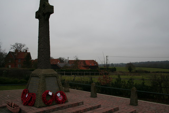
Arborfield Images

Images are sourced within 2km of 51.402812/-0.918168 or Grid Reference SU7567. Thanks to Geograph Open Source API. All images are credited.

Deer for 41 miles! The M4 is 190 miles long and runs from London to South Wales. Major centres close to the motorway include Reading, Swindon, Bristol, Newport, Cardiff and Swansea. The motorway was constructed between 1961 and 1996. The M4 originally crossed the first Severn Road Bridge. It has now been diverted to use the Second Severn Crossing and the motorway over the older bridge has been renumbered as M48.
Wikipedia: <span class="nowrap"><a title="http://en.wikipedia.org/wiki/M4_motorway" rel="nofollow ugc noopener" href="http://en.wikipedia.org/wiki/M4_motorway">Link</a><img style="margin-left:2px;" alt="External link" title="External link - shift click to open in new window" src="https://s1.geograph.org.uk/img/external.png" width="10" height="10"/></span>
Deer for 41 miles!
The M4 is 190 miles long and runs from London to South Wales. Major centres close to the motorway include Reading, Swindon, Bristol, Newport, Cardiff and Swansea. The motorway was constructed between 1961 and 1996. The M4 originally crossed the first Severn Road Bridge. It has now been diverted to use the Second Severn Crossing and the motorway over the older bridge has been renumbered as M48. Wikipedia: LinkExternal link
Roundabout on Reading Road, Arborfield Cross
Arborfield Stores Londis stands for London Independent Supermarkets in case anyone wanted to know
Arborfield Stores
Londis stands for London Independent Supermarkets in case anyone wanted to know
Reading Road, Arborfield Cross
The A327 Arborfield Road
Reading Road, Arborfield
Layby on Reading Road, Arborfield
St Bartholomew, Arborfield: early June 2016
St Bartholomew, Arborfield: church hall
St Bartholomew, Arborfield: churchyard (i)
St Bartholomew, Arborfield: churchyard (ii)
St Bartholomew, Arborfield: churchyard (iii) Also see <span class="nowrap"><a title="http://www.cwgc.org/find-war-dead/casualty/2436226/HYETT,%20JAMES" rel="nofollow ugc noopener" href="http://www.cwgc.org/find-war-dead/casualty/2436226/HYETT,%20JAMES">Link</a><img style="margin-left:2px;" alt="External link" title="External link - shift click to open in new window" src="https://s1.geograph.org.uk/img/external.png" width="10" height="10"/></span>
St Bartholomew, Arborfield: churchyard (iii)
Also see LinkExternal link
St Bartholomew, Arborfield: churchyard (iv) Also see <span class="nowrap"><a title="http://www.cwgc.org/find-war-dead/casualty/2436227/MEARING,%20WILLIAM%20ALBERT" rel="nofollow ugc noopener" href="http://www.cwgc.org/find-war-dead/casualty/2436227/MEARING,%20WILLIAM%20ALBERT">Link</a><img style="margin-left:2px;" alt="External link" title="External link - shift click to open in new window" src="https://s1.geograph.org.uk/img/external.png" width="10" height="10"/></span>
St Bartholomew, Arborfield: churchyard (iv)
Also see LinkExternal link
St Bartholomew, Arborfield: churchyard (v)
St Bartholomew, Arborfield: churchyard (vi)
Inside St Bartholomew, Arborfield (i)
Inside St Bartholomew, Arborfield (ii)
Inside St Bartholomew, Arborfield (iii)
Show me another place!

Arborfield is located at Grid Ref: SU7567 (Lat: 51.402812, Lng: -0.918168)

Unitary Authority: Wokingham

Police Authority: Thames Valley

What 3 Words

///narrow.budget.sector. Near Shinfield, Berkshire

Related Wikis

Arborfield

Arborfield is a village and former civil parish, now in the parish of Arborfield and Newland, in the Borough of Wokingham, on the A327 road in Berkshire...

Arborfield and Newland

Arborfield and Newland is a civil parish in the Wokingham district of Berkshire, England. It had a population of 2,228 according to the 2001 census, increasing...

International Cocoa Quarantine Centre

The International Cocoa Quarantine Centre (ICQC), located in Arborfield, a suburb of Reading, Berkshire, United Kingdom, is an organization aiming to reduce...
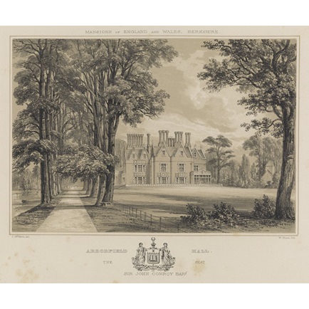
Arborfield Hall

Arborfield Hall was a large country house on the banks of the River Loddon near the village of Arborfield in Berkshire. == History == The site originally...

Nearby Amenities

Located within 500m of 51.402812,-0.918168
Barrier: kissing_gate
Bicycle: no
Foot: yes
Lat/Long: 51.4034508/-0.9199078
Barrier: entrance
Bicycle: no
Foot: yes
Lat/Long: 51.4039284/-0.9117438
Bus Stop
Arborfield Church Lane
Naptan AtcoCode: 035077180002
Naptan NaptanCode: wokajtj
Public Transport: platform
Route Ref: 144
Shelter: yes
Source: survey
Lat/Long: 51.4015065/-0.9207383
Bus Stop
Arborfield Church Lane
Naptan AtcoCode: 035077180001
Naptan NaptanCode: wokajtg
Public Transport: platform
Route Ref: 144
Source: survey
Lat/Long: 51.4013329/-0.9194923
Bus Stop
Arborfield Walden Avenue
Naptan AtcoCode: 035077200002
Naptan NaptanCode: wokajtp
Public Transport: platform
Route Ref: 144
Source: survey
Lat/Long: 51.400584/-0.9161619
Bus Stop
Arborfield Walden Avenue
Naptan AtcoCode: 035077200001
Naptan NaptanCode: wokajtm
Public Transport: platform
Route Ref: 144
Source: survey
Lat/Long: 51.4005547/-0.9155465
Barrier: bollard
Bicycle: yes
Bollard: fixed
Colour: brown
Foot: yes
Horse: yes
Material: wood
Motor Vehicle: designated
Width: 2.2
Lat/Long: 51.3998303/-0.9135032
Post Box
Mapillary: 454414286438294
Post Box Mounting: pier
Post Box Type: lamp
Survey Date: 2022-03-27
Lat/Long: 51.4014847/-0.9206458
Power: pole
Lat/Long: 51.406143/-0.9208845
Power: pole
Lat/Long: 51.4050389/-0.9175374
Power: pole
Lat/Long: 51.4064241/-0.9217401
Power: pole
Lat/Long: 51.4053031/-0.9183688
Power: pole
Lat/Long: 51.4034709/-0.9159681
Power: pole
Lat/Long: 51.4040751/-0.9162982
Power: pole
Lat/Long: 51.4058753/-0.920064
Power: pole
Lat/Long: 51.4056011/-0.9192111
Power: pole
Lat/Long: 51.4047411/-0.9166469
Power: pole
Lat/Long: 51.4053294/-0.9215052
Power: pole
Lat/Long: 51.4046266/-0.923254
Power: pole
Lat/Long: 51.4056021/-0.9207971
Power: pole
Lat/Long: 51.4043455/-0.9242947
Power: pole
Lat/Long: 51.4049797/-0.9223877
Crossing
Crossing: unmarked
Kerb: lowered
Lat/Long: 51.4020052/-0.9241927
Crossing
Bicycle: yes
Crossing: uncontrolled
Crossing Island: yes
Kerb: lowered
Tactile Paving: no
Lat/Long: 51.4022165/-0.9249497
Crossing
Bicycle: yes
Crossing: uncontrolled
Crossing Island: yes
Kerb: lowered
Tactile Paving: no
Lat/Long: 51.4021213/-0.9249638
Crossing
Bicycle: yes
Crossing: uncontrolled
Crossing Island: yes
Kerb: lowered
Lat/Long: 51.4018923/-0.9252217
Give Way
Lat/Long: 51.4013956/-0.9198758
Give Way
Lat/Long: 51.4029963/-0.9180464
Give Way
Lat/Long: 51.4028953/-0.9181882
Bicycle Bypass Backward: yes
Direction: backward
Traffic Calming: chicane
Lat/Long: 51.4000778/-0.9139713
Bicycle Bypass Backward: yes
Direction: backward
Traffic Calming: chicane
Lat/Long: 51.4004246/-0.915148
Give Way
Lat/Long: 51.400518/-0.9158139
Bicycle Bypass Backward: yes
Direction: backward
Traffic Calming: chicane
Lat/Long: 51.4009304/-0.9179597
Bicycle Bypass Forward: yes
Direction: forward
Traffic Calming: chicane
Lat/Long: 51.4016615/-0.9210528
Give Way
Lat/Long: 51.4020248/-0.9241843
The data included in this document is from www.openstreetmap.org. The data is made available under ODbL.

Have you been to Arborfield?

Leave your review of Arborfield below (or comments, questions and feedback).