Arborfield Cross

Settlement in Berkshire

England

Arborfield Cross

Roundabout on Reading Road, Arborfield Cross
Roundabout on Reading Road, Arborfield Cross Credit: David Howard

Arborfield Cross is a small village located in the county of Berkshire, England. Situated approximately 5 miles south-east of Reading, it forms part of the wider Arborfield and Newland civil parish. The village is surrounded by picturesque countryside and is known for its tranquil and rural setting.

Arborfield Cross has a population of around 1,500 residents, and it offers a close-knit community atmosphere. The village features a range of amenities and facilities to cater to the needs of its residents. These include a local primary school, village hall, post office, and a few shops. Additionally, there are several pubs and restaurants where locals and visitors can relax and socialize.

The village is also home to the Arborfield Cross Nature Reserve, which provides a haven for local flora and fauna. The reserve offers beautiful walking trails and is a popular spot for nature enthusiasts and dog walkers.

Arborfield Cross boasts excellent transport links, with easy access to the nearby towns of Reading and Wokingham. It is conveniently located near the A327 road, which connects to the M4 motorway, providing easy access to London and other major cities.

Overall, Arborfield Cross offers a peaceful and idyllic lifestyle, with its charming village setting, local amenities, and access to beautiful countryside. It is an ideal place for those seeking a rural retreat while still being within reach of larger towns and cities.

If you have any feedback on the listing, please let us know in the comments section below.

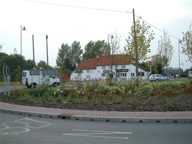
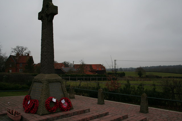
Arborfield Cross Images

Images are sourced within 2km of 51.394938/-0.901105 or Grid Reference SU7666. Thanks to Geograph Open Source API. All images are credited.

Roundabout on Reading Road, Arborfield Cross
Arborfield Stores Londis stands for London Independent Supermarkets in case anyone wanted to know
Arborfield Stores
Londis stands for London Independent Supermarkets in case anyone wanted to know
Reading Road, Arborfield Cross
Poperinghe Way, Arborfield
Verge on Poperinghe Way, Arborfield
Poperinghe Way, Arborfield
The A327 Arborfield Road
Whitehall Drive at the junction of Baird Road
Barkham Road at the junction of Barkham Street Looking towards The Bull at Barkham pub
Barkham Road at the junction of Barkham Street
Looking towards The Bull at Barkham pub
Green by Whitehall Road, Arborfield Garrison
St Bartholomew, Arborfield: early June 2016
School Road at the junction of Langley Common Road
St Bartholomew, Arborfield: church hall
St Bartholomew, Arborfield: churchyard (i)
St Bartholomew, Arborfield: churchyard (ii)
St Bartholomew, Arborfield: churchyard (iii) Also see <span class="nowrap"><a title="http://www.cwgc.org/find-war-dead/casualty/2436226/HYETT,%20JAMES" rel="nofollow ugc noopener" href="http://www.cwgc.org/find-war-dead/casualty/2436226/HYETT,%20JAMES">Link</a><img style="margin-left:2px;" alt="External link" title="External link - shift click to open in new window" src="https://s1.geograph.org.uk/img/external.png" width="10" height="10"/></span>
St Bartholomew, Arborfield: churchyard (iii)
Also see LinkExternal link
St Bartholomew, Arborfield: churchyard (iv) Also see <span class="nowrap"><a title="http://www.cwgc.org/find-war-dead/casualty/2436227/MEARING,%20WILLIAM%20ALBERT" rel="nofollow ugc noopener" href="http://www.cwgc.org/find-war-dead/casualty/2436227/MEARING,%20WILLIAM%20ALBERT">Link</a><img style="margin-left:2px;" alt="External link" title="External link - shift click to open in new window" src="https://s1.geograph.org.uk/img/external.png" width="10" height="10"/></span>
St Bartholomew, Arborfield: churchyard (iv)
Also see LinkExternal link
St Bartholomew, Arborfield: churchyard (v)
Show me another place!

Arborfield Cross is located at Grid Ref: SU7666 (Lat: 51.394938, Lng: -0.901105)

Unitary Authority: Wokingham

Police Authority: Thames Valley

What 3 Words

///snuck.slack.branching. Near Barkham, Berkshire

Nearby Locations

Arborfield Cross

Related Wikis

Arborfield Cross

Arborfield Cross is a village in the civil parish of Arborfield and Newland in the Borough of Wokingham in the English county of Berkshire. == Location... ==

Arborfield Green

Arborfield Green is a new village approximately 1 mile (1.6 km) south east of the village of Arborfield Cross in the English county of Berkshire, previously...

Arborfield

Arborfield is a village and former civil parish, now in the parish of Arborfield and Newland, in the Borough of Wokingham, on the A327 road in Berkshire...

Arborfield and Newland

Arborfield and Newland is a civil parish in the Wokingham district of Berkshire, England. It had a population of 2,228 according to the 2001 census, increasing...

Nearby Amenities

Located within 500m of 51.394938,-0.901105
Traffic Signals
Source: seen on journey
Traffic Signals Direction: backward
Lat/Long: 51.3964699/-0.9012282
Barrier: cycle_barrier
Lat/Long: 51.3964185/-0.901291
Barrier: cycle_barrier
Lat/Long: 51.3960566/-0.9017285
Arborfield
Place: village
Wikidata: Q2753711
Lat/Long: 51.3963375/-0.9054306
Bus Stop
Arborfield Cross / The Swan (nr)
Naptan AtcoCode: 035077220002
Naptan NaptanCode: wokajwa
Public Transport: platform
Route Ref: 144
Source: survey
Lat/Long: 51.3953721/-0.9056884
Post Box
Mapillary: 315843637312161
Post Box Design: type_k
Post Box Type: pillar
Royal Cypher: EIIR
Royal Cypher Wikidata: Q33102113
Survey Date: 2022-03-27
Lat/Long: 51.3954891/-0.9057431
Bus Stop
Arborfield Cross / The Swan (Opp)
Bus: yes
Naptan AtcoCode: 035077220001
Naptan NaptanCode: wokajtw
Public Transport: platform
Route Ref: 144
Source: survey
Lat/Long: 51.3967603/-0.9060451
Car Wash
Village Hand Car Wash
Lat/Long: 51.3958638/-0.9056268
Barrier: cycle_barrier
Lat/Long: 51.3957153/-0.9045394
Barrier: cycle_barrier
Lat/Long: 51.3954493/-0.9037166
Crossing
Crossing: unmarked
Kerb: lowered
Sloped Curb: yes
Source: survey
Lat/Long: 51.3949498/-0.9073292
Barrier: stile
Lat/Long: 51.3905088/-0.9010683
Bench
Lat/Long: 51.3978302/-0.9063154
Bench
Lat/Long: 51.3976489/-0.9060785
Crossing
Crossing: uncontrolled
Crossing Island: yes
Kerb: lowered
Source: Bing
Lat/Long: 51.3973666/-0.9063863
Crossing
Crossing: unmarked
Kerb: lowered
Source: Bing
Lat/Long: 51.3975377/-0.9060761
Crossing
Crossing: unmarked
Kerb: lowered
Sloped Curb: yes
Source: Bing
Lat/Long: 51.3975265/-0.9068711
Crossing
Crossing: uncontrolled
Crossing Island: yes
Kerb: lowered
Source: Bing
Lat/Long: 51.3973719/-0.9065115
Barrier: kerb
Kerb: lowered
Tactile Paving: yes
Lat/Long: 51.3973484/-0.9063323
Crossing
Crossing: unmarked
Kerb: lowered
Source: Bing
Lat/Long: 51.3973783/-0.9060468
Traffic Signals
Source: seen on journey
Traffic Signals Direction: forward
Lat/Long: 51.3964858/-0.9013749
Crossing
Crossing: traffic_signals
Crossing Ref: pelican
Kerb: lowered
Sloped Curb: yes
Source: seen on journey
Lat/Long: 51.3964775/-0.901298
Crossing
Crossing: uncontrolled
Crossing Island: yes
Kerb: lowered
Source: Bing
Lat/Long: 51.3948946/-0.9054457
Traffic Signals
Source: Bing
Traffic Signals Direction: backward
Lat/Long: 51.395015/-0.905481
Crossing
Crossing: unmarked
Kerb: lowered
Sloped Curb: yes
Source: Bing
Lat/Long: 51.3934317/-0.9049479
Traffic Signals
Source: Bing
Traffic Signals Direction: forward
Lat/Long: 51.3950729/-0.9054995
Crossing
Crossing: traffic_signals
Crossing Ref: pelican
Kerb: lowered
Source: seen on journey
Lat/Long: 51.3950449/-0.9054906
Arborfield Cross
Place: locality
Wikidata: Q4784903
Lat/Long: 51.3976172/-0.9065235
Give Way
Direction: forward
Source: Bing
Lat/Long: 51.3947941/-0.9055015
Crossing
Crossing: uncontrolled
Crossing Island: yes
Kerb: lowered
Source: Bing
Lat/Long: 51.3945465/-0.9053676
Crossing
Crossing: unmarked
Kerb: lowered
Sloped Curb: yes
Source: Bing
Lat/Long: 51.3965447/-0.9030187
Give Way
Direction: forward
Source: Bing
Lat/Long: 51.3946876/-0.9053373
Public Bookcase
Booth: K6
Disused Amenity: telephone
Man Made: telephone_box
Mapillary: 496069058664405
Public Bookcase Type: phone_box
Survey Date: 2022-03-27
Tourism: information
Lat/Long: 51.3974406/-0.9067166
Bus Stop
British Legion
Lat/Long: 51.394096/-0.905356
Bus Stop
Ducks Nest Farm
Naptan AtcoCode: 035077260002
Naptan NaptanCode: wokajwm
Lat/Long: 51.39088/-0.9037233
Sally Ann’s Hair Salon
Shop: hairdresser
Lat/Long: 51.3965966/-0.9058402
Entrance: yes
Lat/Long: 51.396613/-0.9010484
Direction: 200
Generator Method: photovoltaic
Generator Output Electricity: yes
Generator Solar Modules: 16
Generator Source: solar
Generator Type: solar_photovoltaic_panel
Location: roof
Power: generator
Lat/Long: 51.3972514/-0.9047904
Direction: 240
Generator Method: photovoltaic
Generator Output Electricity: yes
Generator Solar Modules: 11
Generator Source: solar
Generator Type: solar_photovoltaic_panel
Location: roof
Power: generator
Lat/Long: 51.3951105/-0.9071952
Direction: 135
Generator Method: photovoltaic
Generator Output Electricity: yes
Generator Solar Modules: 12
Generator Source: solar
Generator Type: solar_photovoltaic_panel
Location: roof
Power: generator
Lat/Long: 51.3956213/-0.907315
Direction: 165
Generator Method: photovoltaic
Generator Output Electricity: yes
Generator Solar Modules: 16
Generator Source: solar
Generator Type: solar_photovoltaic_panel
Location: roof
Power: generator
Lat/Long: 51.394964/-0.9062727
Direction: 150
Generator Method: photovoltaic
Generator Output Electricity: yes
Generator Solar Modules: 20
Generator Source: solar
Generator Type: solar_photovoltaic_panel
Location: roof
Power: generator
Lat/Long: 51.394643/-0.9039753
Direction: 150
Generator Method: photovoltaic
Generator Output Electricity: yes
Generator Solar Modules: 12
Generator Source: solar
Generator Type: solar_photovoltaic_panel
Location: roof
Power: generator
Lat/Long: 51.3946759/-0.9038906
Direction: 170
Generator Method: photovoltaic
Generator Output Electricity: yes
Generator Solar Modules: 20
Generator Source: solar
Generator Type: solar_photovoltaic_panel
Location: roof
Power: generator
Lat/Long: 51.3956704/-0.903186
Direction: 180
Generator Method: photovoltaic
Generator Output Electricity: yes
Generator Solar Modules: 44
Generator Source: solar
Generator Type: solar_photovoltaic_panel
Location: roof
Power: generator
Lat/Long: 51.3968127/-0.9008148
Direction: 205
Generator Method: photovoltaic
Generator Output Electricity: yes
Generator Solar Modules: 44
Generator Source: solar
Generator Type: solar_photovoltaic_panel
Location: roof
Power: generator
Lat/Long: 51.3930772/-0.8973262
Direction: 205
Generator Method: photovoltaic
Generator Output Electricity: yes
Generator Solar Modules: 32
Generator Source: solar
Generator Type: solar_photovoltaic_panel
Location: roof
Power: generator
Lat/Long: 51.3928386/-0.8965787
Defibrillator
Defibrillator Location: outside Arborfield Village Hall - down right hand side
Emergency: defibrillator
Lat/Long: 51.3958071/-0.9060281
Barrier: bollard
Bicycle: yes
Bollard: removable
Foot: yes
Horse: yes
Motor Vehicle: no
Lat/Long: 51.3957841/-0.8974811
Slide Deck
Email: lydia@slidedeck.co.uk
Opening Hours: Mo-Fr 09:00-17:00
Phone: +44 118 304 4330
Website: https://www.slidedeck.co.uk
Lat/Long: 51.3960147/-0.9074391
Barrier: kerb
Kerb: lowered
Tactile Paving: yes
Lat/Long: 51.3973807/-0.9064283
Barrier: kerb
Kerb: lowered
Tactile Paving: yes
Lat/Long: 51.3973809/-0.9064815
Barrier: kerb
Kerb: lowered
Tactile Paving: yes
Lat/Long: 51.3973635/-0.9065394
Barrier: kerb
Kerb: lowered
Tactile Paving: yes
Lat/Long: 51.3973956/-0.9060348
Barrier: kerb
Kerb: lowered
Tactile Paving: yes
Lat/Long: 51.3973594/-0.9060629
Barrier: kerb
Kerb: lowered
Tactile Paving: yes
Lat/Long: 51.3975533/-0.9060751
Barrier: kerb
Kerb: lowered
Tactile Paving: yes
Lat/Long: 51.3975152/-0.9060777
The data included in this document is from www.openstreetmap.org. The data is made available under ODbL.

Have you been to Arborfield Cross?

Leave your review of Arborfield Cross below (or comments, questions and feedback).