Ball's Coppice

Wood, Forest in Shropshire

England

Ball's Coppice

Wheatle Farm Track The view of the Shropshire Way near Ebury Hill.
Wheatle Farm Track Credit: Gordon Griffiths

Ball's Coppice is a charming woodland located in Shropshire, England. Situated approximately 3 miles southwest of the town of Bridgnorth, this forested area covers an area of about 100 acres. It is a popular destination for nature enthusiasts, hikers, and those seeking a peaceful retreat from the hustle and bustle of city life.

The coppice is predominantly composed of broadleaf trees, including oak, ash, birch, and beech, creating a diverse and vibrant ecosystem. The dense canopy provides shelter and habitat for various bird species such as woodpeckers, thrushes, and owls, making it a paradise for birdwatchers. Additionally, the forest floor is adorned with a rich carpet of wildflowers during the spring and summer months, adding to the beauty and serenity of the surroundings.

There are several well-maintained walking trails that wind through Ball's Coppice, allowing visitors to explore the woodland at their own pace. These paths range from easy strolls to more challenging hikes, catering to different fitness levels and preferences. Along the way, walkers can enjoy the tranquil atmosphere, listen to the soothing sounds of nature, and perhaps even spot some wildlife.

The coppice is managed by local authorities who ensure its preservation and provide necessary facilities for visitors. These amenities include picnic areas, benches, and information boards, offering visitors a chance to relax and learn more about the flora and fauna that thrive in the woodland.

Overall, Ball's Coppice is a delightful natural haven, offering a peaceful escape and an opportunity to immerse oneself in the beauty of Shropshire's woodlands.

If you have any feedback on the listing, please let us know in the comments section below.

Ball's Coppice Images

Images are sourced within 2km of 52.753517/-2.7142786 or Grid Reference SJ5117. Thanks to Geograph Open Source API. All images are credited.

Wheatle Farm Track The view of the Shropshire Way near Ebury Hill.
Wheatle Farm Track
The view of the Shropshire Way near Ebury Hill.
Field Edge Path The footpath near Wheatle Farm.
Field Edge Path
The footpath near Wheatle Farm.
Sunderton Farm View
Sunderton Farm View
Private Lane The view from footpath near Sunderton Farm.
Private Lane
The view from footpath near Sunderton Farm.
Hay Stack The view from footpath near Sunderton Farm.
Hay Stack
The view from footpath near Sunderton Farm.
Stile Bridge The view of the footpath near Sunderton Farm.
Stile Bridge
The view of the footpath near Sunderton Farm.
Field Pool The view from footpath near Sunderton Farm.
Field Pool
The view from footpath near Sunderton Farm.
Field View The view from footpath near Sunderton Farm.
Field View
The view from footpath near Sunderton Farm.
Pool with Stile The view from footpath near Dell Farm, with the walkers equivalent of the Water Jump.
Pool with Stile
The view from footpath near Dell Farm, with the walkers equivalent of the Water Jump.
Path to Stile The view from footpath near Dell Farm.
Path to Stile
The view from footpath near Dell Farm.
Sundorne  Farm Track The view south near Sundorne Farm.
Sundorne Farm Track
The view south near Sundorne Farm.
Dell Farm View
Dell Farm View
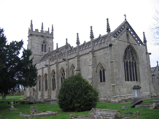
Battlefield Church St. Mary Magdalene, built on orders of Henry IV after victory in the Battle of Shrewsbury in 1406 over the Marcher Lords.
Battlefield Church
St. Mary Magdalene, built on orders of Henry IV after victory in the Battle of Shrewsbury in 1406 over the Marcher Lords.
St. Mary Magdalene The church constructed in 1406 in commemoration of King Henry IV's victory in the Battle of Shrewsbury in 1403. The tower was added between 1478 and 1520 by Adam Grafton.
St. Mary Magdalene
The church constructed in 1406 in commemoration of King Henry IV's victory in the Battle of Shrewsbury in 1403. The tower was added between 1478 and 1520 by Adam Grafton.
St. Mary Magdalene The church is isolated and surrounded by open fields North of the suburbs of Shrewsbury.
St. Mary Magdalene
The church is isolated and surrounded by open fields North of the suburbs of Shrewsbury.
Battlefield Church St. Mary Magdalene, is no longer used for regular services but it is still consecrated and is cared for by the Churches Conservation Trust charity.
Battlefield Church
St. Mary Magdalene, is no longer used for regular services but it is still consecrated and is cared for by the Churches Conservation Trust charity.
Private Lane Private lane adjacent St. Mary Magdalene, leading to the Field House, Battlefield.
Private Lane
Private lane adjacent St. Mary Magdalene, leading to the Field House, Battlefield.
Battlefield Gate Gateway to footpath to 1403 Battlefield Visitor Centre at Battlefield Farm.
Battlefield Gate
Gateway to footpath to 1403 Battlefield Visitor Centre at Battlefield Farm.
Show me another place!

Ball's Coppice is located at Grid Ref: SJ5117 (Lat: 52.753517, Lng: -2.7142786)

Unitary Authority: Shropshire

Police Authority: West Mercia

What 3 Words

///dragging.dislodge.hotspot. Near Astley, Shropshire

Related Wikis

Upper Battlefield, Shropshire

Upper Battlefield is a small village in Shropshire, England. It lies on the A49 just north of Battlefield. The Welsh Marches railway line runs through...

St Mary Magdalene's Church, Battlefield

St Mary Magdalene's Church is in the village of Battlefield, Shropshire, England, dedicated to Jesus' companion Mary Magdalene. It was built on the site...

Battle of Shrewsbury

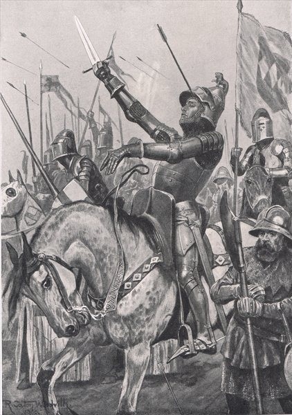
The Battle of Shrewsbury was a battle fought on 21 July 1403, waged between an army led by the Lancastrian King Henry IV and a rebel army led by Henry...

Battlefield, Shropshire

Battlefield is a village and suburb of the town of Shrewsbury in Shropshire, England. It is 3 miles (5 km) north of the town centre. The village is today...

Nearby Amenities

Located within 500m of 52.753517,-2.7142786
Cafe
Battlefield 1403 Sparrow's Cafe
Addr City: Battlefield
Addr Housename: Battlefield Farm
Addr Postcode: SY4 3DB
Fhrs Id: 62785
Source Addr: FHRS Open Data
Lat/Long: 52.7528024/-2.7205334
Upper Battlefield
Place: village
Lat/Long: 52.7561744/-2.7163351
Shop: convenience
Lat/Long: 52.7527038/-2.7205623
Battlefield Falconry Centre
Attraction: animal
Operator: Battlefield 1403
Website: https://battlefieldfalconrycentre.co.uk/
Lat/Long: 52.7532422/-2.7209147
The data included in this document is from www.openstreetmap.org. The data is made available under ODbL.

Have you been to Ball's Coppice?

Leave your review of Ball's Coppice below (or comments, questions and feedback).