Eight Acre Copse

Wood, Forest in Somerset Somerset West and Taunton

England

Eight Acre Copse

Fitzhead: north west from the village Landscape with woods and fields. Looking north towards the Quantocks
Fitzhead: north west from the village Credit: Martin Bodman

Eight Acre Copse is a picturesque woodland located in Somerset, England. Spanning approximately eight acres, this copse is a captivating destination for nature enthusiasts and those seeking tranquility amidst the beauty of the natural world.

Nestled in the rolling hills of Somerset, Eight Acre Copse is renowned for its diverse ecosystem and abundant wildlife. The copse consists of a mix of deciduous and coniferous trees, creating a rich and vibrant tapestry of colors throughout the year. Ancient oak trees, with their gnarled and moss-covered branches, provide a majestic presence within the woodland.

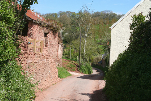
Visitors to Eight Acre Copse can explore a network of well-maintained trails that wind their way through the forest. These trails offer a variety of walking and hiking options, catering to all levels of fitness and ability. Along the way, hikers may encounter a range of flora and fauna, including bluebells, primroses, and various species of birds and butterflies.

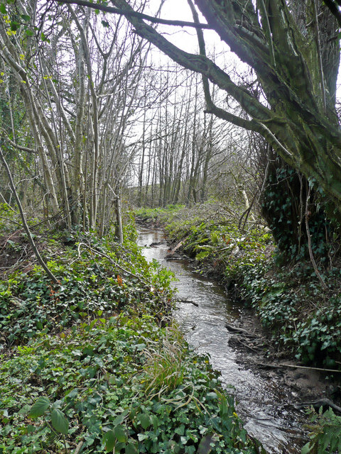
The copse is also home to a small stream that meanders through the woodland, adding to its enchanting charm. The gentle babbling of the water provides a peaceful soundtrack to the overall ambience of the forest.

Eight Acre Copse is a popular destination for photographers, artists, and nature lovers alike, who are drawn to its serene and idyllic setting. Whether one is seeking a quiet stroll, a picnic spot, or simply a place to unwind and connect with nature, Eight Acre Copse offers a truly mesmerizing experience.

If you have any feedback on the listing, please let us know in the comments section below.

Eight Acre Copse Images

Images are sourced within 2km of 51.065821/-3.252305 or Grid Reference ST1230. Thanks to Geograph Open Source API. All images are credited.

Fitzhead: north west from the village Landscape with woods and fields. Looking north towards the Quantocks
Fitzhead: north west from the village
Landscape with woods and fields. Looking north towards the Quantocks
Lydeard St Lawrence: Chapel Leigh Chapel Leigh is a hamlet consisting of two farms and a number of cottages. Looking east-north-east
Lydeard St Lawrence: Chapel Leigh
Chapel Leigh is a hamlet consisting of two farms and a number of cottages. Looking east-north-east
Halse: barns at Northway Farm Looking north-north-west
Halse: barns at Northway Farm
Looking north-north-west
Fitzhead: limekiln near Burrow Hill Farm Looking south
Fitzhead: limekiln near Burrow Hill Farm
Looking south
Fitzhead: towards Pitsford Hill The field nearest the camera adjoins the lane from Fitzhead to Oakhampton Farm. In the distance is Willett Hill. Looking north-north-west
Fitzhead: towards Pitsford Hill
The field nearest the camera adjoins the lane from Fitzhead to Oakhampton Farm. In the distance is Willett Hill. Looking north-north-west
Hoccombe Farm Hoccombe Farm seen from the meadow behind it. Leat running in the foreground. Date: 22/04/2006.
Hoccombe Farm
Hoccombe Farm seen from the meadow behind it. Leat running in the foreground. Date: 22/04/2006.
Hoccombe Farm Hoccombe Farm and buildings, seen from the orchard.
Hoccombe Farm
Hoccombe Farm and buildings, seen from the orchard.
Burrow Hill Viewed from the bridge south of Moor Mill Farm.
Burrow Hill
Viewed from the bridge south of Moor Mill Farm.
Somerset stream One of the head streams of the Tone which arise from the Brendon Hills east of Exmoor.
Somerset stream
One of the head streams of the Tone which arise from the Brendon Hills east of Exmoor.
Road approaching Northway Farm The road from Ash Priors, still following the C18 turnpike from Bishop's Lydeard to Wiveliscombe shown in <a href="https://www.geograph.org.uk/photo/1594159">ST1429 : Road to Northway</a>, is dropping into the Halse Water valley. One of the barns at Northway Farm can be glimpsed around the bend.
Road approaching Northway Farm
The road from Ash Priors, still following the C18 turnpike from Bishop's Lydeard to Wiveliscombe shown in ST1429 : Road to Northway, is dropping into the Halse Water valley. One of the barns at Northway Farm can be glimpsed around the bend.
Northway Farm The C19 farmhouse, seen from the lane approaching from Ash Priors (see also <a href="https://www.geograph.org.uk/photo/1594275">ST1329 : Road approaching Northway Farm</a>) is listed <span class="nowrap"><a title="http://webapp1.somerset.gov.uk/her/details.asp?prn=40152" rel="nofollow ugc noopener" href="http://webapp1.somerset.gov.uk/her/details.asp?prn=40152">Link</a><img style="margin-left:2px;" alt="External link" title="External link - shift click to open in new window" src="https://s1.geograph.org.uk/img/external.png" width="10" height="10"/></span> .
Northway Farm
The C19 farmhouse, seen from the lane approaching from Ash Priors (see also ST1329 : Road approaching Northway Farm) is listed LinkExternal link .
Coxland's Rock approaching Northway Farm Taken from roughly the same spot as <a href="https://www.geograph.org.uk/photo/1594309">ST1328 : Coxland's Rock at Halse Water</a>, close to the bridge over the Halse Water, but looking in the other direction. Northway Farm, across a gridline, also appears in <a href="https://www.geograph.org.uk/photo/1594289">ST1329 : Northway Farm</a> and <a href="https://www.geograph.org.uk/photo/163679">ST1329 : Halse: barns at Northway Farm</a>.
Coxland's Rock approaching Northway Farm
Taken from roughly the same spot as ST1328 : Coxland's Rock at Halse Water, close to the bridge over the Halse Water, but looking in the other direction. Northway Farm, across a gridline, also appears in ST1329 : Northway Farm and ST1329 : Halse: barns at Northway Farm.
Buttressed wall, Fitzhead This fine buttressed wall climbing towards the main village street borders the grounds of the listed Fitzhead Court <span class="nowrap"><a title="http://webapp1.somerset.gov.uk/her/details.asp?prn=40338" rel="nofollow ugc noopener" href="http://webapp1.somerset.gov.uk/her/details.asp?prn=40338">Link</a><img style="margin-left:2px;" alt="External link" title="External link - shift click to open in new window" src="https://s1.geograph.org.uk/img/external.png" width="10" height="10"/></span> , but perhaps surprisingly is not itself listed. On the left are an arched doorway into the grounds and a pump.
Buttressed wall, Fitzhead
This fine buttressed wall climbing towards the main village street borders the grounds of the listed Fitzhead Court LinkExternal link , but perhaps surprisingly is not itself listed. On the left are an arched doorway into the grounds and a pump.
Pump and trough, Fitzhead These appear in <a href="https://www.geograph.org.uk/photo/1715237">ST1228 : Buttressed wall, Fitzhead</a>, and a closer view of one of the buttresses is behind the black metal pump.
Pump and trough, Fitzhead
These appear in ST1228 : Buttressed wall, Fitzhead, and a closer view of one of the buttresses is behind the black metal pump.
Fitzhead parish school The datestone reads "Fitzhead parish school 1846". The sandstone building, with its pedimented doorcase, is not listed, although this part of the village is a conservation area. Beyond is a listed pump shelter of 1904 <span class="nowrap"><a title="http://webapp1.somerset.gov.uk/her/details.asp?prn=16736" rel="nofollow ugc noopener" href="http://webapp1.somerset.gov.uk/her/details.asp?prn=16736">Link</a><img style="margin-left:2px;" alt="External link" title="External link - shift click to open in new window" src="https://s1.geograph.org.uk/img/external.png" width="10" height="10"/></span> - so the village has two pumps, not far apart (see also <a href="https://www.geograph.org.uk/photo/1715276">ST1228 : Pump and trough, Fitzhead</a>).
Fitzhead parish school
The datestone reads "Fitzhead parish school 1846". The sandstone building, with its pedimented doorcase, is not listed, although this part of the village is a conservation area. Beyond is a listed pump shelter of 1904 LinkExternal link - so the village has two pumps, not far apart (see also ST1228 : Pump and trough, Fitzhead).
Buttressed wall, Fitzhead <a href="https://www.geograph.org.uk/photo/1715237">ST1228 : Buttressed wall, Fitzhead</a> from the opposite direction. Though unlisted, the wall forms part of the village's conservation area.
Buttressed wall, Fitzhead
ST1228 : Buttressed wall, Fitzhead from the opposite direction. Though unlisted, the wall forms part of the village's conservation area.
Cridlands, Fitzhead According to <span class="nowrap"><a title="http://webapp1.somerset.gov.uk/her/details.asp?prn=40211" rel="nofollow ugc noopener" href="http://webapp1.somerset.gov.uk/her/details.asp?prn=40211">Link</a><img style="margin-left:2px;" alt="External link" title="External link - shift click to open in new window" src="https://s1.geograph.org.uk/img/external.png" width="10" height="10"/></span> , the house, with its Ham stone mullions, is "C17, largely rebuilt to its original design" in the last century. On the right is an unbuttressed section of <a href="https://www.geograph.org.uk/photo/1715521">ST1228 : Buttressed wall, Fitzhead</a>.
Cridlands, Fitzhead
According to LinkExternal link , the house, with its Ham stone mullions, is "C17, largely rebuilt to its original design" in the last century. On the right is an unbuttressed section of ST1228 : Buttressed wall, Fitzhead.
Cottage, Chapel Leigh The cottage is on the lane south of Chapel Leigh, in a side valley of the Halse Water.
Cottage, Chapel Leigh
The cottage is on the lane south of Chapel Leigh, in a side valley of the Halse Water.
Show me another place!

Eight Acre Copse is located at Grid Ref: ST1230 (Lat: 51.065821, Lng: -3.252305)

Administrative County: Somerset

District: Somerset West and Taunton

Police Authority: Avon and Somerset

What 3 Words

///bracelet.nods.highly. Near Bishops Lydeard, Somerset

Related Wikis

Fitzhead Court and The Manor

Fitzhead Court and The Manor in Fitzhead, Somerset, England was built in the late 16th century and has now been split into two buildings. It is a Grade...

Gaulden Manor

Gaulden Manor (also Gavelden or Gaveldene) is a Grade II* listed country house to the southeast of Tolland, Somerset, England. It is a double storied building...

Church of St James the Great, Fitzhead

The Anglican Church of St James the Great in Fitzhead, Somerset, England was built in the 15th century. It is a Grade II* listed building. == History... ==

Fitzhead

Fitzhead is a village and civil parish in Somerset, England, situated approximately 6 miles (9.7 km) north west of Taunton. The village has an estimated...

Lydeard St Lawrence

Lydeard St Lawrence or St Lawrence Lydiard is a village and civil parish in Somerset, England, situated 7 miles (11.3 km) north west of Taunton. The village...

Ruby Country

Ruby Country is the name given to the rural inland hinterland of north-west Devon, UK. It covers 45 parishes around the market towns of Holsworthy and...

Tolland, Somerset

Tolland is a village and civil parish in Somerset, England, situated 9 miles (14.5 km) north west of Taunton, between the Brendon Hills and Quantock Hills...

Combe Florey House

Combe Florey House in Combe Florey, Somerset, England is a country house dating from the early 18th century. It replaced an Elizabethan manor house which...

Nearby Amenities

Located within 500m of 51.065821,-3.252305
West Leigh
Place: hamlet
Lat/Long: 51.0670612/-3.2578513
Ford: yes
Lat/Long: 51.0644375/-3.2581933
Brand: National Grid
Brand Wikidata: Q1465461
Material: wood
Operator: National Grid Electricity Distribution Plc
Operator Old: Western Power Distribution
Operator Wikidata: Q7988183
Owner: National Grid Electricity Distribution (South West) Plc
Owner Wikidata: Q114397866
Power: pole
Lat/Long: 51.068664/-3.2543269
Brand: National Grid
Brand Wikidata: Q1465461
Design: h-frame
Devices: 1
Frequency: 50
Guyed: yes
Line Management: split
Material: wood
Operator: National Grid Electricity Distribution Plc
Operator Old: Western Power Distribution
Operator Wikidata: Q7988183
Owner: National Grid Electricity Distribution (South West) Plc
Owner Wikidata: Q114397866
Phases: 3
Power: pole
Transformer: distribution
Lat/Long: 51.0684124/-3.25705
Brand: National Grid
Brand Wikidata: Q1465461
Material: wood
Operator: National Grid Electricity Distribution Plc
Operator Old: Western Power Distribution
Operator Wikidata: Q7988183
Owner: National Grid Electricity Distribution (South West) Plc
Owner Wikidata: Q114397866
Power: pole
Lat/Long: 51.0685186/-3.2557411
Brand: National Grid
Brand Wikidata: Q1465461
Material: wood
Operator: National Grid Electricity Distribution Plc
Operator Old: Western Power Distribution
Operator Wikidata: Q7988183
Owner: National Grid Electricity Distribution (South West) Plc
Owner Wikidata: Q114397866
Power: pole
Lat/Long: 51.0687411/-3.2533526
Brand: National Grid
Brand Wikidata: Q1465461
Material: wood
Operator: National Grid Electricity Distribution Plc
Operator Old: Western Power Distribution
Operator Wikidata: Q7988183
Owner: National Grid Electricity Distribution (South West) Plc
Owner Wikidata: Q114397866
Power: pole
Lat/Long: 51.0688169/-3.252336
Brand: National Grid
Brand Wikidata: Q1465461
Material: wood
Operator: National Grid Electricity Distribution Plc
Operator Old: Western Power Distribution
Operator Wikidata: Q7988183
Owner: National Grid Electricity Distribution (South West) Plc
Owner Wikidata: Q114397866
Power: pole
Lat/Long: 51.0689696/-3.2506543
Brand: National Grid
Brand Wikidata: Q1465461
Material: wood
Operator: National Grid Electricity Distribution Plc
Operator Old: Western Power Distribution
Operator Wikidata: Q7988183
Owner: National Grid Electricity Distribution (South West) Plc
Owner Wikidata: Q114397866
Power: pole
Lat/Long: 51.0690537/-3.2496645
Brand: National Grid
Brand Wikidata: Q1465461
Material: wood
Operator: National Grid Electricity Distribution Plc
Operator Old: Western Power Distribution
Operator Wikidata: Q7988183
Owner: National Grid Electricity Distribution (South West) Plc
Owner Wikidata: Q114397866
Power: pole
Lat/Long: 51.0691271/-3.2487968
Brand: National Grid
Brand Wikidata: Q1465461
Cables: 3
Location: outdoor
Material: wood
Operator: National Grid Electricity Distribution Plc
Operator Old: Western Power Distribution
Operator Wikidata: Q7988183
Owner: National Grid Electricity Distribution (South West) Plc
Owner Wikidata: Q114397866
Power: switch
Switch: mechanical
Lat/Long: 51.0692282/-3.2477038
Give Way
Direction: backward
Lat/Long: 51.0670535/-3.2578305
Guyed: yes
Material: wood
Operator: Wessex Water
Power: pole
Lat/Long: 51.0693559/-3.255908
Brand: National Grid
Brand Wikidata: Q1465461
Material: wood
Operator: National Grid Electricity Distribution Plc
Operator Old: Western Power Distribution
Operator Wikidata: Q7988183
Owner: National Grid Electricity Distribution (South West) Plc
Owner Wikidata: Q114397866
Power: pole
Lat/Long: 51.067198/-3.2578003
Brand: National Grid
Brand Wikidata: Q1465461
Material: wood
Operator: National Grid Electricity Distribution Plc
Operator Old: Western Power Distribution
Operator Wikidata: Q7988183
Owner: National Grid Electricity Distribution (South West) Plc
Owner Wikidata: Q114397866
Power: pole
Lat/Long: 51.0678343/-3.2586265
Brand: National Grid
Brand Wikidata: Q1465461
Material: wood
Operator: National Grid Electricity Distribution Plc
Operator Old: Western Power Distribution
Operator Wikidata: Q7988183
Owner: National Grid Electricity Distribution (South West) Plc
Owner Wikidata: Q114397866
Power: pole
Lat/Long: 51.0674896/-3.2578292
Brand: National Grid
Brand Wikidata: Q1465461
Guyed: yes
Material: wood
Operator: National Grid Electricity Distribution Plc
Operator Old: Western Power Distribution
Operator Wikidata: Q7988183
Owner: National Grid Electricity Distribution (South West) Plc
Owner Wikidata: Q114397866
Power: pole
Lat/Long: 51.067991/-3.2578459
Brand: National Grid
Brand Wikidata: Q1465461
Guyed: yes
Material: wood
Operator: National Grid Electricity Distribution Plc
Operator Old: Western Power Distribution
Operator Wikidata: Q7988183
Owner: National Grid Electricity Distribution (South West) Plc
Owner Wikidata: Q114397866
Power: pole
Lat/Long: 51.0682485/-3.2577433
Brand: National Grid
Brand Wikidata: Q1465461
Guyed: yes
Material: wood
Operator: National Grid Electricity Distribution Plc
Operator Old: Western Power Distribution
Operator Wikidata: Q7988183
Owner: National Grid Electricity Distribution (South West) Plc
Owner Wikidata: Q114397866
Power: pole
Lat/Long: 51.0682986/-3.2574778
Brand: National Grid
Brand Wikidata: Q1465461
Guyed: yes
Material: wood
Operator: National Grid Electricity Distribution Plc
Operator Old: Western Power Distribution
Operator Wikidata: Q7988183
Owner: National Grid Electricity Distribution (South West) Plc
Owner Wikidata: Q114397866
Power: pole
Lat/Long: 51.0683349/-3.2579754
Watering Place
Access: private
Lat/Long: 51.0700835/-3.2516561
Brand: National Grid
Brand Wikidata: Q1465461
Devices: 1
Frequency: 50
Guyed: yes
Location Transition: yes
Material: wood
Operator: National Grid Electricity Distribution Plc
Operator Old: Western Power Distribution
Operator Wikidata: Q7988183
Owner: National Grid Electricity Distribution (South West) Plc
Owner Wikidata: Q114397866
Phases: 1
Power: pole
Transformer: distribution
Lat/Long: 51.0683619/-3.246653
The data included in this document is from www.openstreetmap.org. The data is made available under ODbL.

Have you been to Eight Acre Copse?

Leave your review of Eight Acre Copse below (or comments, questions and feedback).