Lower Charlwood Copse

Wood, Forest in Devon Teignbridge

England

Lower Charlwood Copse

Bladders An odd place name on the map that I assume must refer to this somewhat forgotten barn just off the lane between Ashcombe and Mamhead. Behind, Zigzag Wood rises from Mamhead Bottom. It's all a bit physical.
Bladders Credit: Derek Harper

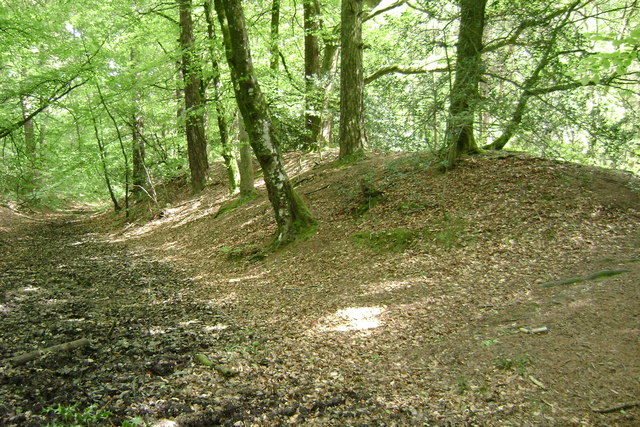
Lower Charlwood Copse is a picturesque woodland located in the county of Devon, England. Situated in the southwest region of the country, this enchanting forest covers an area of approximately 50 acres. The copse is characterized by its dense and diverse vegetation, consisting primarily of broadleaf trees such as oak, beech, and ash.

The woodland is renowned for its natural beauty and tranquil atmosphere, making it a popular destination for nature lovers and walkers. A network of well-maintained footpaths meanders through the copse, allowing visitors to explore its hidden treasures. The forest floor is covered with a lush carpet of moss, ferns, and wildflowers, creating a vibrant and colorful landscape.

Lower Charlwood Copse is also home to a variety of wildlife. The dense foliage provides a perfect habitat for numerous species of birds, including woodpeckers, owls, and thrushes. Squirrels, badgers, and deer are frequently spotted in the copse, adding to its charm and allure.

Visitors to the copse can enjoy a range of activities, from leisurely walks and picnics to birdwatching and photography. The peaceful surroundings of Lower Charlwood Copse offer a welcome escape from the hustle and bustle of everyday life.

Managed by the local authorities, efforts are made to preserve the natural habitat and protect the wildlife that calls the copse home. Visitors are encouraged to respect the environment and adhere to the designated paths to minimize disruption to the ecosystem.

Overall, Lower Charlwood Copse is a captivating woodland that showcases the beauty of nature in Devon. Whether it be for a leisurely stroll or a peaceful retreat, this enchanting forest offers a serene and rejuvenating experience for all who visit.

If you have any feedback on the listing, please let us know in the comments section below.

Lower Charlwood Copse Images

Images are sourced within 2km of 50.59303/-3.5339511 or Grid Reference SX9178. Thanks to Geograph Open Source API. All images are credited.

Bladders An odd place name on the map that I assume must refer to this somewhat forgotten barn just off the lane between Ashcombe and Mamhead. Behind, Zigzag Wood rises from Mamhead Bottom. It's all a bit physical.
Bladders
An odd place name on the map that I assume must refer to this somewhat forgotten barn just off the lane between Ashcombe and Mamhead. Behind, Zigzag Wood rises from Mamhead Bottom. It's all a bit physical.
Luton - Hayes Farm Mews Entrance to holiday accommodation at Hayes Farm, a dairy farm.
Luton - Hayes Farm Mews
Entrance to holiday accommodation at Hayes Farm, a dairy farm.
Luton (Devon) Village amenities - the old telephone contains a book library and the roadside cabinet contains eggs and vegetables ("hedge veg") for sale.
Luton (Devon)
Village amenities - the old telephone contains a book library and the roadside cabinet contains eggs and vegetables ("hedge veg") for sale.
Luton (Devon) - Church Luton has a chapel of ease, dedicated to St John the Evangelist, built in the 19th century.
Luton (Devon) - Church
Luton has a chapel of ease, dedicated to St John the Evangelist, built in the 19th century.
Luton (Devon) Valley with grassland and woodland by Cherrycombe.
Luton (Devon)
Valley with grassland and woodland by Cherrycombe.
Luton - Hayes Farm Farmhouse and holiday cottages surrounded by a patchwork of hedgerow-lined fields.
Luton - Hayes Farm
Farmhouse and holiday cottages surrounded by a patchwork of hedgerow-lined fields.
Luton - Hayes Farm Farmhouse and holiday cottages surrounded by a patchwork of hedgerow-lined fields.
Luton - Hayes Farm
Farmhouse and holiday cottages surrounded by a patchwork of hedgerow-lined fields.
County Bridge Marker on Church Hill in Ashcombe County Bridge Marker on the south side of Church Hill, built into stone wall of St Nectan's churchyard in Ashcombe parish. The stone marks the extent of roadway adjoining the bridge that the County was obliged to maintain.
Milestone Society National ID: DV_ACMH01br
County Bridge Marker on Church Hill in Ashcombe
County Bridge Marker on the south side of Church Hill, built into stone wall of St Nectan's churchyard in Ashcombe parish. The stone marks the extent of roadway adjoining the bridge that the County was obliged to maintain. Milestone Society National ID: DV_ACMH01br
Luton (Devon) - The Elizabethan A cosy Devon village pub which sources local food from the farming community.
<span class="nowrap"><a title="www.elizabethaninn.co.uk" rel="nofollow ugc noopener" href="http://www.elizabethaninn.co.uk">Link</a><img style="margin-left:2px;" alt="External link" title="External link - shift click to open in new window" src="https://s1.geograph.org.uk/img/external.png" width="10" height="10"/></span>
Luton (Devon) - The Elizabethan
A cosy Devon village pub which sources local food from the farming community. LinkExternal link
Warning notice, Ashcombe At the foot of Ashcombe footpath 1 - see <a href="https://www.geograph.org.uk/photo/6833003">SX9279 : War memorial and lane at Ashcombe</a> and <a href="https://www.geograph.org.uk/photo/6833034">SX9279 : Old School House, Ashcombe</a>.
Warning notice, Ashcombe
Woodland, Ashcombe By Oakpark Lane.
Woodland, Ashcombe
By Oakpark Lane.
Hillside above Ashcombe From Oakpark Lane, looking towards Great Haldon. Oakpark Wood is on the left.
Hillside above Ashcombe
From Oakpark Lane, looking towards Great Haldon. Oakpark Wood is on the left.
Oakpark Lane Followed by Ashcombe Footpath 1 as it drops towards the junction by the war memorial.
Oakpark Lane
Followed by Ashcombe Footpath 1 as it drops towards the junction by the war memorial.
Oakpark Lane Looking in the opposite direction from <a href="https://www.geograph.org.uk/photo/7002683">SX9279 : Oakpark Lane</a>. This is Ashcombe Footpath 1
Oakpark Lane
Looking in the opposite direction from SX9279 : Oakpark Lane. This is Ashcombe Footpath 1
Valley side above Ashcombe From Oakpark Lane. The wood on the right is unnamed on maps. Up on the left is Obelisk Plantation.
Valley side above Ashcombe
From Oakpark Lane. The wood on the right is unnamed on maps. Up on the left is Obelisk Plantation.
Oakpark Lane Followed by Ashcombe Footpath 1 as it climbs from the junction by the war memorial.
Oakpark Lane
Followed by Ashcombe Footpath 1 as it climbs from the junction by the war memorial.
Oakpark Lane Dark trees line the southwest side of the slightly sunken lane, which is followed by Ashcombe Footpath 1.
Oakpark Lane
Dark trees line the southwest side of the slightly sunken lane, which is followed by Ashcombe Footpath 1.
Valley side above Ashcombe Looking right from <a href="https://www.geograph.org.uk/photo/6833345">SX9279 : Cereal crop by Oakpark Wood</a>, and a slightly more detailed view than <a href="https://www.geograph.org.uk/photo/3082501">SX9279 : By Oakpark Lane</a>.
Valley side above Ashcombe
Looking right from SX9279 : Cereal crop by Oakpark Wood, and a slightly more detailed view than SX9279 : By Oakpark Lane.
Show me another place!

Lower Charlwood Copse is located at Grid Ref: SX9178 (Lat: 50.59303, Lng: -3.5339511)

Administrative County: Devon

District: Teignbridge

Police Authority: Devon and Cornwall

What 3 Words

///lyricist.lifeboats.cargo. Near Bishopsteignton, Devon

Related Wikis

Ashcombe

Ashcombe is a village and civil parish in the Teignbridge district of Devon, England, about eight miles south of the city of Exeter. The parish is surrounded...

Castle Dyke

Castle Dyke is an Iron Age hill fort situated between Chudleigh and Dawlish in Devon, England. The fort is situated on a hilltop at approximately 140 metres...

Ideford Common

Ideford Common is a Site of Special Scientific Interest consisting of an area of lowland heath in Devon, England. The site is a habitat for nightjars and...

Luton, Teignbridge

Luton is a village in Devon, England, within Teignbridge local authority area. Historically Luton formed part of Ashcombe Hundred.The village is in the...

Haldon Aerodrome

Haldon Aerodrome was the first airfield in Devon. Established in the 1920s as a private flying field, it developed into an airport with scheduled airline...
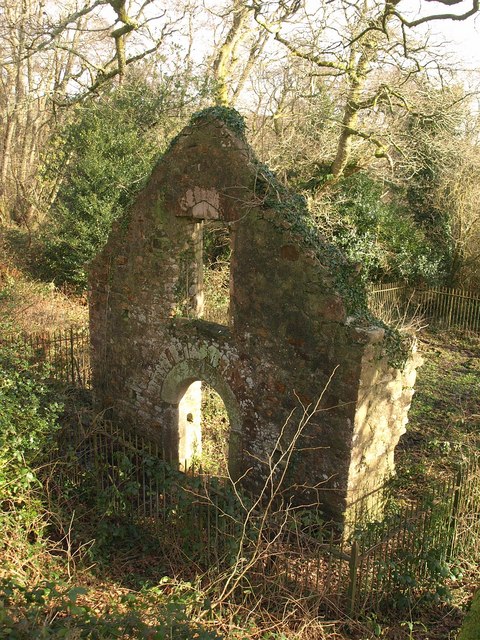
Lidwell Chapel

Lidwell Chapel, also known as St Mary's Chapel, is a medieval chapel, now in ruins, within the parish of Dawlish in Devon, England. The chapel is a Grade...

Ideford

Ideford (or Ideford Parish) is a village in the Teignbridge district of Devon, England. It is 5 miles (8 km) north of Newton Abbot. To the west is the...
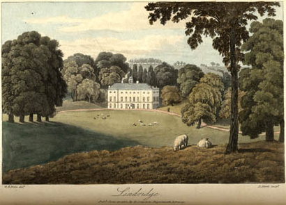
Lindridge House

Lindridge House was a large 17th-century mansion (with 20th-century alterations), one of the finest in the south-west situated about 1 mile south of Ideford...

Nearby Amenities

Located within 500m of 50.59303,-3.5339511
Design: asymmetric
Power: tower
Lat/Long: 50.5939281/-3.5282047
Design: asymmetric
Power: tower
Lat/Long: 50.5921281/-3.5328589
Design: asymmetric
Power: tower
Lat/Long: 50.5911571/-3.5352977
Design: asymmetric
Power: tower
Lat/Long: 50.5905132/-3.536964
Higher Charlwood Farm
Place: farm
Lat/Long: 50.5957447/-3.5335729
Power: pole
Lat/Long: 50.5918603/-3.5282153
Power: pole
Lat/Long: 50.5915742/-3.5298005
Power: pole
Lat/Long: 50.5910284/-3.5325712
Power: pole
Lat/Long: 50.5911962/-3.5341162
Location Transition: yes
Power: pole
Lat/Long: 50.5913665/-3.5356289
Power: pole
Lat/Long: 50.5913903/-3.5381448
Power: pole
Lat/Long: 50.5913393/-3.5310841
Power: pole
Lat/Long: 50.591535/-3.5370679
The data included in this document is from www.openstreetmap.org. The data is made available under ODbL.

Have you been to Lower Charlwood Copse?

Leave your review of Lower Charlwood Copse below (or comments, questions and feedback).