Ashcombe

Civil Parish in Devon Teignbridge

England

Ashcombe

Farmland, Mamhead Bottom Looking left from <a href="https://www.geograph.org.uk/photo/6833852">SX9279 : Sheep pasture by Oakpark Wood</a>, with woods clothing the slopes of Great Haldon.
Farmland, Mamhead Bottom Credit: Derek Harper

Ashcombe is a civil parish located in the county of Devon, in the South West of England. It covers an area of approximately 6 square miles and is situated in the picturesque countryside, surrounded by rolling hills and lush green fields. The parish is nestled between the towns of Teignmouth and Newton Abbot, offering residents and visitors a peaceful and rural setting.

Ashcombe is known for its charming and quaint village, which is home to a small community of around 300 people. The village consists of a scattering of traditional stone cottages and a handful of amenities, including a local pub and a village hall. The parish also includes several farms and agricultural land, which contributes to the rural character of the area.

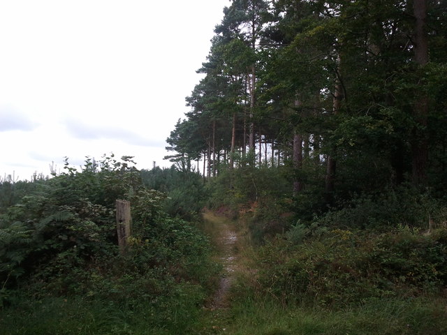
The landscape of Ashcombe is predominantly agricultural, with farmland and pastures dominating the scenery. It is a popular area for outdoor enthusiasts, with numerous walking trails and bridleways crisscrossing the countryside, providing opportunities to explore the surrounding natural beauty.

Historically, Ashcombe has been inhabited since ancient times, with evidence of early settlements and Roman occupation in the area. The parish has a rich history, and there are several historic landmarks and buildings of interest, including St. Nectan's Church, which dates back to the 13th century.

Overall, Ashcombe offers a peaceful and idyllic lifestyle, perfect for those seeking a rural retreat in the heart of Devon's countryside.

If you have any feedback on the listing, please let us know in the comments section below.

Ashcombe Images

Images are sourced within 2km of 50.600615/-3.528062 or Grid Reference SX9178. Thanks to Geograph Open Source API. All images are credited.

Farmland, Mamhead Bottom Looking left from <a href="https://www.geograph.org.uk/photo/6833852">SX9279 : Sheep pasture by Oakpark Wood</a>, with woods clothing the slopes of Great Haldon.
Farmland, Mamhead Bottom
Looking left from SX9279 : Sheep pasture by Oakpark Wood, with woods clothing the slopes of Great Haldon.
Lane to Westley Manor Looking the other way from <a href="https://www.geograph.org.uk/photo/6833897">SX9279 : Lane by Kiln Brake</a>. This stretch of lane is always damp.
Lane to Westley Manor
Looking the other way from SX9279 : Lane by Kiln Brake. This stretch of lane is always damp.
Cereal crop below Mamhead Bottom Looking right from <a href="https://www.geograph.org.uk/photo/6833897">SX9279 : Lane by Kiln Brake</a>, and left from <a href="https://www.geograph.org.uk/photo/7003379">SX9280 : Lane to Westley Manor</a>, up a field that is central to <a href="https://www.geograph.org.uk/photo/7003214">SX9280 : Farmland, Mamhead Bottom</a> and <a href="https://www.geograph.org.uk/photo/6834331">SX9280 : Farmland below Mamhead Bottom</a>.
Cereal crop below Mamhead Bottom
Cereal crop below Mamhead Bottom Looking right from <a href="https://www.geograph.org.uk/photo/7003395">SX9280 : Cereal crop below Mamhead Bottom</a>, and left from <a href="https://www.geograph.org.uk/photo/7003379">SX9280 : Lane to Westley Manor</a>.
Cereal crop below Mamhead Bottom
Lane to Ashcombe A reverse view of <a href="https://www.geograph.org.uk/photo/7003379">SX9280 : Lane to Westley Manor</a>.
Lane to Ashcombe
A reverse view of SX9280 : Lane to Westley Manor.
Lane to Westley Manor Looking the other way from <a href="https://www.geograph.org.uk/photo/7003452">SX9280 : Lane to Ashcombe</a>.
Lane to Westley Manor
Looking the other way from SX9280 : Lane to Ashcombe.
Holm oak near Westley Manor By the lane from Ashcombe.
Holm oak near Westley Manor
By the lane from Ashcombe.
Trees near Westley Manor At the bend where <a href="https://www.geograph.org.uk/photo/6834452">SX9279 : Valley below Westley Manor</a> was taken, looking right.
Trees near Westley Manor
At the bend where SX9279 : Valley below Westley Manor was taken, looking right.
Farmland and woods near Mamhead Grange From a gateway on the left of the bend shown in <a href="https://www.geograph.org.uk/photo/7003495">SX9280 : Trees near Westley Manor</a>.
Farmland and woods near Mamhead Grange
From a gateway on the left of the bend shown in SX9280 : Trees near Westley Manor.
Farmland and woods near Mamhead Grange Looking right from <a href="https://www.geograph.org.uk/photo/7004198">SX9280 : Farmland and woods near Mamhead Grange</a>. The trees on the left can be seen in <a href="https://www.geograph.org.uk/photo/6834248">SX9280 : Trees near Westley Manor</a>.
Farmland and woods near Mamhead Grange
Looking right from SX9280 : Farmland and woods near Mamhead Grange. The trees on the left can be seen in SX9280 : Trees near Westley Manor.
Gate near Westley Manor From which <a href="https://www.geograph.org.uk/photo/6834452">SX9279 : Valley below Westley Manor</a> was taken.
Gate near Westley Manor
From which SX9279 : Valley below Westley Manor was taken.
Westley House and Manor A spring version of <a href="https://www.geograph.org.uk/photo/3081440">SX9280 : Westley Manor Farm</a>.
Westley House and Manor
A spring version of SX9280 : Westley Manor Farm.
Westley Manor Farm Seen from the lane from Ashcombe.
Westley Manor Farm
Seen from the lane from Ashcombe.
Green lane near Mamhead Grange The ridge lane approaches the junction by Westley Manor and Mamhead Grange.
Green lane near Mamhead Grange
The ridge lane approaches the junction by Westley Manor and Mamhead Grange.
Crossroads near Westley Farm
Fields near Larkbeare Farm There is a good view over to the sea from here.
Fields near Larkbeare Farm
There is a good view over to the sea from here.
Path into the woods
Path into the woods
Footpath from the road to Mamhead Bottom
Show me another place!

Ashcombe is located at Grid Ref: SX9178 (Lat: 50.600615, Lng: -3.528062)

Administrative County: Devon

District: Teignbridge

Police Authority: Devon & Cornwall

What 3 Words

///span.prayers.shudders. Near Dawlish, Devon

Related Wikis

Ashcombe

Ashcombe is a village and civil parish in the Teignbridge district of Devon, England, about eight miles south of the city of Exeter. The parish is surrounded...
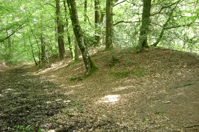
Castle Dyke

Castle Dyke is an Iron Age hill fort situated between Chudleigh and Dawlish in Devon, England. The fort is situated on a hilltop at approximately 140 metres...

Ideford Common

Ideford Common is a Site of Special Scientific Interest consisting of an area of lowland heath in Devon, England. The site is a habitat for nightjars and...

Mamhead House

Mamhead House, Mamhead, Devon, is a country house dating from 1827. Its origins are older but the present building was constructed for Robert William Newman...

Mamhead

Mamhead is a rural village and civil parish near Dawlish and Kenton in Devon, South West England, in the Teignbridge local authority area. Current community...

Luton, Teignbridge

Luton is a village in Devon, England, within Teignbridge local authority area. Historically Luton formed part of Ashcombe Hundred.The village is in the...

Haldon Aerodrome

Haldon Aerodrome was the first airfield in Devon. Established in the 1920s as a private flying field, it developed into an airport with scheduled airline...
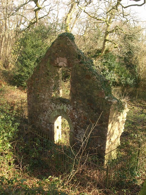
Lidwell Chapel

Lidwell Chapel, also known as St Mary's Chapel, is a medieval chapel, now in ruins, within the parish of Dawlish in Devon, England. The chapel is a Grade...

Nearby Amenities

Located within 500m of 50.600615,-3.528062
Lower Charlwood Farm
Place: farm
Lat/Long: 50.5976069/-3.5232572
Power: pole
Lat/Long: 50.5966252/-3.5263297
Power: pole
Lat/Long: 50.5965622/-3.525297
The data included in this document is from www.openstreetmap.org. The data is made available under ODbL.

Have you been to Ashcombe?

Leave your review of Ashcombe below (or comments, questions and feedback).